- Newark, New Jersey
-
For other places with the same name, see Newark."Brick City" redirects here. For the township in Ocean County, see Brick Township, New Jersey.
City of Newark — City — Part of Downtown Newark skyline
Flag
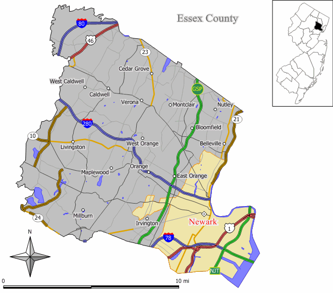
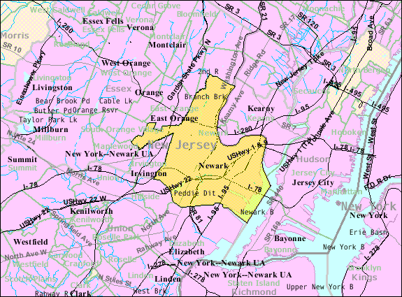
SealNickname(s): The Brick City, The Gateway City Map of Newark in Essex County. Inset: Location of Essex County highlighted in the State of New Jersey. Census Bureau map of Newark, New Jersey
Coordinates: 40°44′7″N 74°11′6″W / 40.73528°N 74.185°WCoordinates: 40°44′7″N 74°11′6″W / 40.73528°N 74.185°W Country United States State New Jersey County Essex Founded/Incorporated 1666/1836 Government – Type Faulkner Act (Mayor-Council) – Mayor Cory Booker, term of office 2010–2014 Area[1] – City 26.0 sq mi (67.3 km2) – Land 23.8 sq mi (61.6 km2) – Water 2.2 sq mi (5.7 km2) Elevation 30 ft (9 m) Population (2010)[2] – City 277,140 (68th) – Density 13,301/sq mi (5,034.8/km2) – Metro 18,818,536 – Demonym Newarker Time zone Eastern (EST) (UTC-5) – Summer (DST) EDT (UTC-4) ZIP codes 07101-07108, 07112, 07114[3] Area code(s) 862, 973 FIPS code 34-51000[4][5] GNIS feature ID 0878762[6] Website http://www.ci.newark.nj.us/ Newark (
 /ˈnjuː.ək/)[7] is the largest city in the American state of New Jersey, and the seat of Essex County. As of the 2010 United States Census, Newark had a population of 277,140, maintaining its status as the largest municipality in New Jersey.[2] It is the 68th largest city in the U.S.[8] and one of the nation's major air, shipping, and rail hubs.
Newark is located in the heart of New Jersey's Gateway Region, approximately 8 miles (13 km) west of Manhattan. Its location near the Atlantic Ocean on Newark Bay has helped make its port facility, Port Newark, the key container shipping facility for the New York metropolitan area, and the largest on the East Coast. It is the home of Newark Liberty International Airport, the first municipal commercial airport in the United States, and one of the busiest today. Newark is headquarters to numerous corporations such as Prudential Financial and PSEG, universities campuses of UMDNJ, Rutgers University and New Jersey Institute of Technology, as well as numerous cultural and sports venues.
This ethnically diverse city is divided into five wards, and contains a variety of neighborhoods ranging in character from bustling urban districts to quiet suburban enclaves.
Contents
History
Main article: History of Newark, New JerseyNewark was originally founded in 1666 by Connecticut Puritans led by Robert Treat from the New Haven Colony. The city saw tremendous industrial and population growth during the 19th century and early 20th century, and experienced racial tension and urban decline in the second half of the 20th century, culminated by the 1967 Newark riots. The city has experienced some revitalization during the 1990s and early 21st century.
Newark was originally formed as a township on October 31, 1693, based on the Newark Tract, which was first purchased on July 11, 1667. Newark was granted a Royal Charter on April 27, 1713, and was incorporated as one of New Jersey's initial 104 townships by an act of the New Jersey Legislature on February 21, 1798. During its time as a township, portions were taken to form Springfield Township (April 14, 1794), Caldwell Township (now known as Fairfield Township (February 16, 1798), Orange Township (November 27, 1806), Bloomfield Township (March 23, 1812) and Clinton Township (April 14, 1834, remainder reabsorbed by Newark on March 5, 1902). Newark was reincorporated as a city on April 11, 1836, replacing Newark Township, based on the results of a referendum passed on March 18, 1836. The previously independent Vailsburg borough was annexed by Newark on January 1, 1905. In 1926, South Orange Township, changed its name to Maplewood. As a result of this, a portion of Maplewood known as Ivy Hill was reannexed to Newark's Vailsburg.[9]
Geography and climate
Geography
 Map of the Newark metropolitan area, including adjacent suburbs
Located at 40° 44' 14" north and 74° 10' 55" west, Newark is 24.14 square miles (62.5 km2) in area. It has the second smallest land area among 100 most populous cities in the U.S, after neighboring Jersey City. The city's altitude ranges from 0 to 273.4 feet (83.3 m) above sea level, with the average being 55 feet (17 m).[10] Newark is essentially a large basin sloping towards the Passaic River, with a few valleys formed by meandering streams. Historically, Newark's high places have been its wealthier neighborhoods. In the 19th century and early 20th century, the wealthy congregated on the ridges of Forest Hill, High Street, and Weequahic.
Until the 20th century, the marshes on Newark Bay were difficult to develop. The marshes were essentially wilderness, with a few dumps, warehouses, and cemeteries on their edges. In the 19th century, Newarkers mourned that a fifth of their city could not be used for development. However, in the 20th century, the Port Authority was able to reclaim much of the marshland for the further expansion of Newark Airport, as well as the growth of the port lands.
Newark is surrounded by residential suburbs to the west (on the slope of the Watchung Mountains), the Passaic River and Newark Bay to the east, dense urban areas to the south and southwest, and middle-class residential suburbs and industrial areas to the north. The city is the center of New Jersey's Gateway Region.
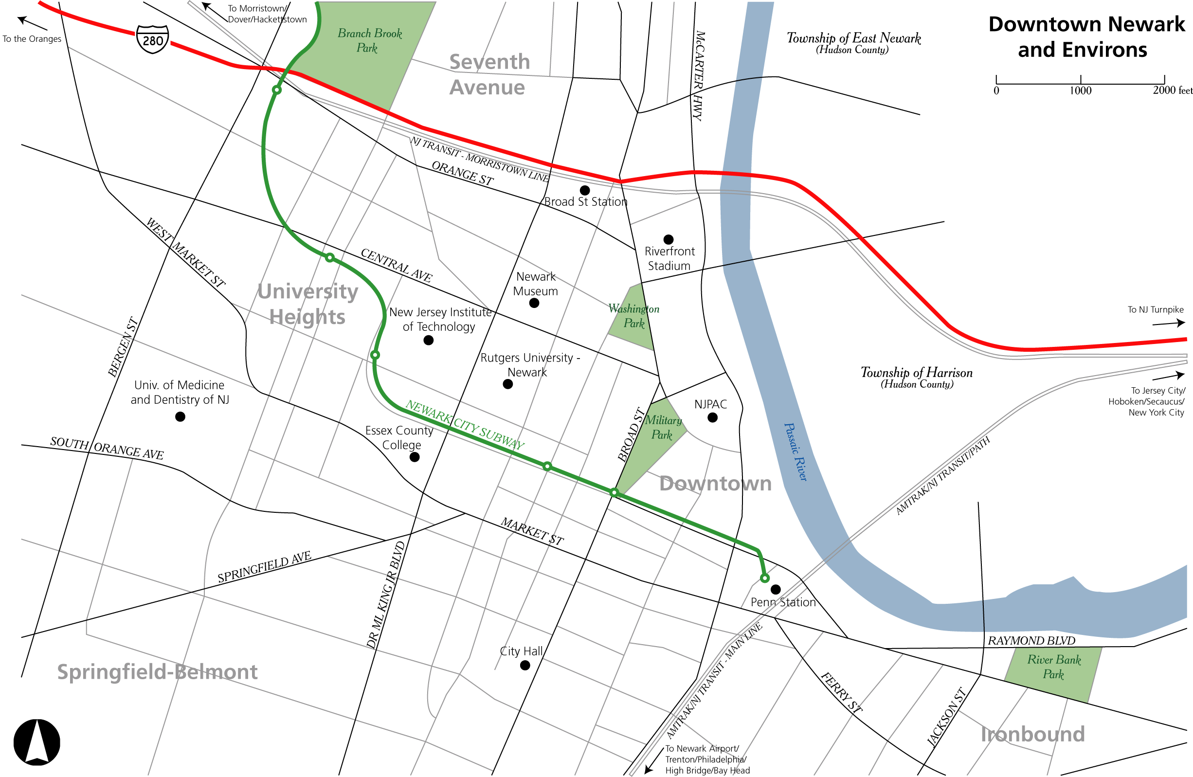
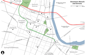 Map of Downtown Newark and surrounding areas
Neighborhoods
Main article: List of neighborhoods in Newark, New JerseyNewark is New Jersey's largest and second-most diverse city, after neighboring Jersey City.
The city is divided into five political wards, which are often used by residents to identify their place of habitation. In recent years, residents have begun to identify with specific neighborhood names instead of the larger ward appellations. Nevertheless, the wards remain relatively distinct. Industrial uses, coupled with the airport and seaport lands, are concentrated in the East and South Wards, while residential neighborhoods exist primarily in the North, Central, and West Wards.
State law requires that wards be compact and contiguous and that the largest ward may not exceed the population of the smallest by more than 10% of the average ward size. While it is possible that ward boundaries may not need to be changed if population changes in each ward were similar across the city, if the ward boundaries need to be redrawn they will be done so by a board of ward commissioners consisting of two Democrats and two Republicans appointed at the county level and the municipal clerk.[11] Redrawing of ward lines in previous decades have shifted traditional boundaries, so that downtown currently occupies portions of the East and Central Wards. The boundaries of the wards are altered for various political and demographic reasons and sometimes gerrymandered, especially the northeastern portion of the West Ward.
Newark's North Ward is the ridge to the east of Branch Brook Park, and is home to approximately 200,000 residents. Its neighborhoods include Broadway, Newark, New Jersey, Mount Pleasant, and the affluent Forest Hill section.[12] Forest Hill contains the Forest Hill Historic District, which is registered on state and national historic registers, and contains many impressive and prominent homes comparable in quality to South Orange and Montclair. A row of high-quality residential towers with security guards and secure parking lines Mt. Prospect Avenue in the Forest Hill neighborhood. These prominent buildings attract residents from all over the region. The North Ward has lost geographic area in recent times, so that the ward's southern boundary is now significantly further north than the traditional boundary near Interstate 280. The North Ward historically had a large Italian population, which has transitioned to Latino in recent decades. Large portions of the North Ward, especially areas where the homes are very close together, are over 90% Latino. There remains pockets of African-Americans in the North Ward.
The Central Ward also used to be known as the old Third Ward contains much of the city's original history including the Lincoln Park, Military Park and the James Street Commons Historic Districts. The Ward contains the University Heights, The Coast/Lincoln Park, Government Center, Springfield/Belmont and Seventh Avenue Neighborhoods. Of these neighborhood designations only University Heights, a newer designation for the area that was the subject of the 1968 novel Howard Street by Nathan Heard, is still in common usage. This primarily because of the massive demolition and replacement of old structures and neighborhoods with new. The central ward extends at one point as far north as 2nd Avenue.
In the 19th century the Central Ward was inhabited by Germans and other white Catholic and Christian groups. The German inhabitants were later replaced by Jews, who were then replaced by Blacks. The increased academic footprint in the University Heights Neighborhood has produced a gentrification, with landmark buildings seeing new life. Located in the Central Ward is the largest health sciences university in the nation, UMDNJ-New Jersey Medical School. It is also home to three other universities – New Jersey Institute of Technology (NJIT), Rutgers University - Newark, and Essex County College. The Central Ward forms the present-day heart of Newark. It has 26 public schools, two police precincts, including headquarters, four firehouses, and one branch library.[13]
The West Ward comprises the neighborhoods of Vailsburg, Ivy Hill, West Side, Fairmount and once affluentRoseville sections. Roseville is mainly Latino and Italian American. The West Ward, once a predominately Irish-American, Polish, and Ukrainian neighborhood, is now home to neighborhoods composed primarily of African Americans, Guyanese, and Haitians.[14]
The South Ward comprises the Weequahic, Clinton Hill, Dayton, and South Broad Valley neighborhoods. The South Ward, once home to residents of predominately Jewish descent, now has ethnic neighborhoods made up primarily of African-Americans, Dominicans and Puerto Ricans. The South Ward is represented by Council Member Ras Baraka. The city’s second-largest hospital, Newark Beth Israel Medical Center, can be found in the South Ward, as can 17 public schools, five daycare centers, three branch libraries, one police precinct, a mini precinct, and three fire houses.[15]
Finally, the East Ward consists of Newark's downtown commercial district, as well as the heavily Portuguese Ironbound neighborhood, where much of Newark's industry was located in the 19th century. Today, due to the enterprise of its immigrant population, the Ironbound (also known as "Down Neck") is a very successful part of Newark. The East Ward is transitioning from Portuguese to Brazilian. It is largely composed of houses packed very closely together, but the neighborhoods are notably safe, thriving and successful.
Climate
Newark has a humid subtropical climate that borders on humid continental (Köppen Cfa / Dfa), with cold winters and very warm to hot, humid summers. Its proximity to the ocean has a moderating effect. Also, being near to the Atlantic Ocean means Newark tends to have warmer winters than cities at a similar latitude or even somewhat further south, such as Chicago, Columbus, Pittsburgh, and St. Louis. The January average is 31.3 °F (−0.4 °C), and temperatures down to the 15 °F (−9.4 °C) range are not uncommon, though they rarely fall to 0 °F (−18 °C) or below. With a seasonal total of 26 inches (66.0 cm), snow cover does not usually remain for long. Spring in the area is of reasonable length and relatively devoid of temperature extremes. Summers are particularly hot and humid, with a July average of 77.2 °F (25.1 °C), and highs exceeding 90 °F (32 °C) on an average 25 days per year.[16] Heat advisories are not uncommon during the summer months, particularly July and August, when temperatures can reach 100 °F (38 °C) with high humidity. The city cools off at a moderate pace during autumn.
The city receives precipitation ranging from 2.9 to 4.7 inches (74 to 119 mm) monthly, usually falling on 8 to 12 days monthly. Measurable snowfall occurs each winter, but in lesser amounts than cities in the Midwest at a similar latitude. The highest recorded temperature was 108 °F (42 °C) on July 22, 2011.
Climate data for Newark, New Jersey Month Jan Feb Mar Apr May Jun Jul Aug Sep Oct Nov Dec Year Record high °F (°C) 74
(23)76
(24)89
(32)97
(36)99
(37)102
(39)108
(42)105
(41)105
(41)93
(34)85
(29)76
(24)108
(42)Average high °F (°C) 38.1
(3.4)41.1
(5.1)50.1
(10.1)60.8
(16.0)71.4
(21.9)80.2
(26.8)85.2
(29.6)83.2
(28.4)75.7
(24.3)64.7
(18.2)53.7
(12.1)43.0
(6.1)62.3 Average low °F (°C) 24.4
(−4.2)26.6
(−3)34.2
(1.2)43.7
(6.5)54.1
(12.3)63.5
(17.5)69.1
(20.6)67.7
(19.8)59.9
(15.5)48.2
(9.0)39.1
(3.9)29.8
(−1.2)46.7 Record low °F (°C) −8
(−22.2)−14
(−25.6)6
(−14.4)16
(−8.9)33
(1)41
(5)51
(11)45
(7)35
(2)25
(−3.9)12
(−11.1)−8
(−22.2)−14
(−25.6)Precipitation inches (mm) 3.98
(101.1)2.96
(75.2)4.21
(106.9)3.92
(99.6)4.46
(113.3)3.40
(86.4)4.68
(118.9)4.02
(102.1)4.01
(101.9)3.16
(80.3)3.88
(98.6)3.57
(90.7)46.25
(1,174.8)Snowfall inches (cm) 8.9
(22.6)8.4
(21.3)4.3
(10.9).8
(2)0
(0)0
(0)0
(0)0
(0)0
(0)0
(0).6
(1.5)3.0
(7.6)26.0
(66)Avg. precipitation days (≥ 0.01 in) 10.5 9.9 10.9 10.8 11.7 10.7 10.0 9.6 9.0 8.3 9.5 10.7 121.6 Avg. snowy days (≥ 0.1 in) 4.9 4.1 2.3 .4 0 0 0 0 0 0 .4 2.3 14.4 Source: NOAA[16] Surrounding municipalities

East Orange and Bloomfield Township Belleville Twp E. Newark, Harrison
and KearnyMaplewood Twp, So. Orange
and Irvington Twp
Jersey City  Newark

Hillside Twp Elizabeth Bayonne Demographics
Newark, New Jersey Census Pop. %± 1790 1,000 — 1800 6,000 500.0% 1820 6,507 — 1830 10,953 68.3% 1840 17,290 57.9% 1850 38,894 125.0% 1860 71,941 85.0% 1870 105,059 46.0% 1880 136,508 29.9% 1890 181,830 33.2% 1900 246,070 35.3% 1910 347,469 41.2% 1920 414,524 19.3% 1930 442,337 6.7% 1940 429,760 −2.8% 1950 438,776 2.1% 1960 405,220 −7.6% 1970 381,930 −5.7% 1980 329,248 −13.8% 1990 275,221 −16.4% 2000 273,546 −0.6% 2010 277,140 1.3% Population sources:
1930-1990[17][18] 2000[19] 2010[20][2]As of the census[4] of 2000, there are 273,546 people, 91,382 households, and 61,956 families residing in Newark.[19] The population density was 11,400/mile² (4,400/km²), or 21,000/mile² (8,100 km²) once airport, railroad, and seaport lands are excluded, Newark has the eighth highest density in the nation of any city with over 250,000 residents.
The racial makeup of the city as of the 2000 Census was 53.46% African American, 26.52% White, 1.19% Asian, 0.37% Native American, 0.05% Pacific Islander, 14.05% from other races, and 4.36% from two or more races. 29.47% of the population are Hispanic or Latino of any race.[19]
As of the 2000 Census, 49.2% of the city's 80,622 residents who identified themselves as Hispanic or Latino were from Puerto Rico, while 9.4% were from Ecuador and 7.8% from the Dominican Republic.[21] There is a significant Portuguese-speaking community concentrated in the New York district. 2000 Census data showed that Newark had 15,801 residents of Portuguese ancestry (5.8% of the population), while an additional 5,805 (2.1% of the total) were of Brazilian ancestry.[22]
It is commonly believed that heavily immigrant areas of Newark are tremendously undercounted in the Census, especially in the East Ward. Many households refuse to participate in the census, with immigrants often reluctant to submit census forms because they believe that the information could be used to justify their deportation.[23]
There were 91,382 households out of which 35.2% had children under the age of 18 living with them, 31.0% were married couples living together, 29.3% had a female householder with no husband present, and 32.2% were non-families. 26.6% of all households were made up of individuals and 8.8% had someone living alone who was 65 years of age or older. The average household size was 2.8 and the average family size was 3.40.[19]
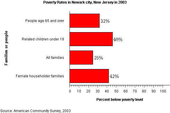
 Poverty rates, as of 2003
In the city the population was spread out with 27.9% under the age of 18, 12.1% from 18 to 24, 32.0% from 25 to 44, 18.7% from 45 to 64, and 9.3% who were 65 years of age or older. The median age was 31 years. For every 100 females, there were 94.2 males. For every 100 females of age 18 and over, there were 91.1 males.[19]
Poverty and lack of investment
Poverty remains a consistent problem in Newark, despite its revitalization in recent years. The 1967 fights resulted in a significant population loss of both white and latinos middle classes which continued from the 1970s through to the 1990s. The city lost over 100,000 residents between 1960 and 1990.
Portions of Newark are rebounding and improving due to the abandonment and demolition of public housing projects, especially the Baxter Terrace area.
According to numbers from 2003, the median income for a household in the city is $26,913, and the median income for a family is $30,781. Males have a median income of $29,748 versus $25,734 for females. The per capita income for the city is $13,009. 28.4% of the population and 25.5% of families are below the poverty line. 36.6% of those under the age of 18 and 24.1% of those 65 and older are living below the poverty line.[19] The city's unemployment rate is 12%.
Government
Local government
Effective as of July 1, 1954, the voters of the city of Newark, by a referendum held on November 3, 1953 and under the Optional Municipal Charter Law (commonly known as the Faulkner Act), adopted the Faulkner Act (Mayor-Council) Plan C as the form of local government.[24]
There are nine council members are elected on a nonpartisan basis at the regular municipal election or at the general election for terms of four years: one council member from each of five wards and four council members on an at-large basis. The mayor is also elected for a term of four years.
The Municipal Council is the legislative branch of city government. It enacts by ordinance, resolution or motion the local laws which govern the people of the city, and is responsible for approval of the municipal budget, establishment of financial controls, and setting of salaries of elected officials and top appointed administrators. It may reduce or increase appropriations requested by the Mayor. By these methods the Council decides "what" the city will do about any particular matter, and then the Mayor and cabinet members decide "how" to do it. It also renders advice and consent on the Mayor's appointments and policy programs, and may investigate, when necessary, any branch of municipal government. The Council also authorizes a continuing audit by an outside firm, of all city financial transactions.
As established by ordinance, regular public meetings of the Municipal Council are held on the first Wednesday of each month at 1:00 p.m., and the third Wednesday of each month at 7:00 p.m. in the Municipal Council Chamber in City Hall. Exceptions are made for national or religious holidays. During July and August only one meeting is held each month. A special meeting of the Municipal Council may be called by the President or a majority of its members or by the Mayor whenever an emergency requires immediate action.
As of 2010, Newark's Municipal Council include the following members:
- Donald M. Payne, Jr. (Council President/Council Member-at-Large) Who is also a Freeholder-at-Large
- Augusto Amador (Council Member, East Ward)
- Ras J. Baraka (Council Member, South Ward, also Principal, Central High School)
- Mildred C. Crump (Council Member-at-Large)
- Carlos M. Gonzalez (Council Member-at-Large)
- Luis A. Quintana (Council Member-at-Large)
- Anibal Ramos, Jr. (Council Vice President/Council Member, North Ward)
- Ronald C. Rice (Council Member, West Ward)
- Darrin S. Sharif (Council Member, Central Ward)
Federal, state and county representation
Newark is split between the 10th and 13th Congressional districts. New Jersey's Tenth Congressional District is represented by Donald M. Payne (D, Newark). New Jersey's Thirteenth Congressional District is represented by Albio Sires (D, West New York). New Jersey is represented in the United States Senate by Frank Lautenberg (D, Cliffside Park) and Bob Menendez (D, Hoboken).
Part of Newark is in the 27th Legislative District of the New Jersey Legislature, which is represented in the New Jersey Senate by Richard Codey (D, Roseland) and in the New Jersey General Assembly by Mila Jasey (D, South Orange) and John F. McKeon (D, West Orange).[25] Another part is in the 28th District of the New Jersey Legislature, which is represented in the New Jersey Senate by Ronald Rice (D, Newark) and in the New Jersey General Assembly by Ralph R. Caputo (D, Belleville) and Cleopatra Tucker (D, Newark).[26] The remainder is in the 29th District of the New Jersey Legislature, which is represented in the New Jersey Senate by Teresa Ruiz (D, Newark) and in the New Jersey General Assembly by Alberto Coutinho (D, Newark) and L. Grace Spencer (D, Newark).[27]
Politics
On the national level, Newark leans strongly toward the Democratic Party. In 2008, Democrat Barack Obama received 91% of the vote.[28]
Political corruption
Newark has been marred with episodes of political corruption throughout the years. Five of the last seven Mayors of Newark have been indicted on criminal charges, including the last three Mayors: Hugh Addonizio, Kenneth Gibson, and Sharpe James. As reported by Newsweek:
“ "... every mayor since 1962 (except the current one, Cory Booker) has been indicted for crimes committed while in office."[29] ” Addonizio was mayor of Newark from 1962 to 1970. A son of Italian immigrants, a tailor and WWII veteran, he ran on a reform platform, defeating the incumbent, Leo Carlin, who, ironically, he characterized as corrupt and a part of the political machine of the era. During the 1967 riots, it was found that Addonizio and other city officials were taking kickbacks from city contractors. He was convicted of extortion and conspiracy in 1970, and was sentenced to ten years in federal prison.
His successor was Kenneth Gibson, the city's first African American mayor, elected in 1970. He pleaded guilty to federal tax evasion in 2002 as part of a plea agreement on fraud and bribery charges. During his tenure as Mayor in 1980, he was tried and acquitted of giving out no-show jobs by an Essex County jury.[30]
Sharpe James, who defeated Gibson in 1986 and declined to run for a sixth term in 2006, was indicted on 33 counts of conspiracy, mail fraud, and wire fraud by a federal grand jury sitting in Newark. The grand jury charged that James illegally used city-owned credit cards for personal gain, illegally spending $58,000, and that James orchestrated a scheme to sell city-owned land at below-market prices to his companion, who immediately re-sold the land to developers and gained profit of over $500,000. James had an initial appearance on July 12, 2007 and entered a plea of not guilty to the 25 counts facing him. However, James was eventually found guilty on fraud charges by a federal jury on April 17, 2008 for his role in the conspiring to rig land sales at nine city-owned properties. The former mayor was sentenced to serve up to 27 months in prison.
Crime
In 1996, TIME Magazine ranked Newark "The Most Dangerous City in the Nation."[31] By 2007, however, the city recorded a total of 99 homicides for the year, representing a significant drop from the record of 161 murders set in 1981.[32][33][34][35] The number of murders in 2008 dropped to 65, a decline of 30% from the previous year and the lowest in the city since 2002 when there were also 65 murders.[36]
In the 2006 Morgan Quitno survey, Newark was ranked as the 22nd most dangerous city in the United States out of 371 municipalities.[37] In the 2007 rankings, now performed by CQ Press, Newark was the 20th most dangerous city in America of 378 cities surveyed. In 2005, Newark was ranked as the 24th most dangerous city, and as of 2010, stands at 23rd.[38] In March 2010, Newark had its first calendar month without a homicide since 1966.[39]
Economy
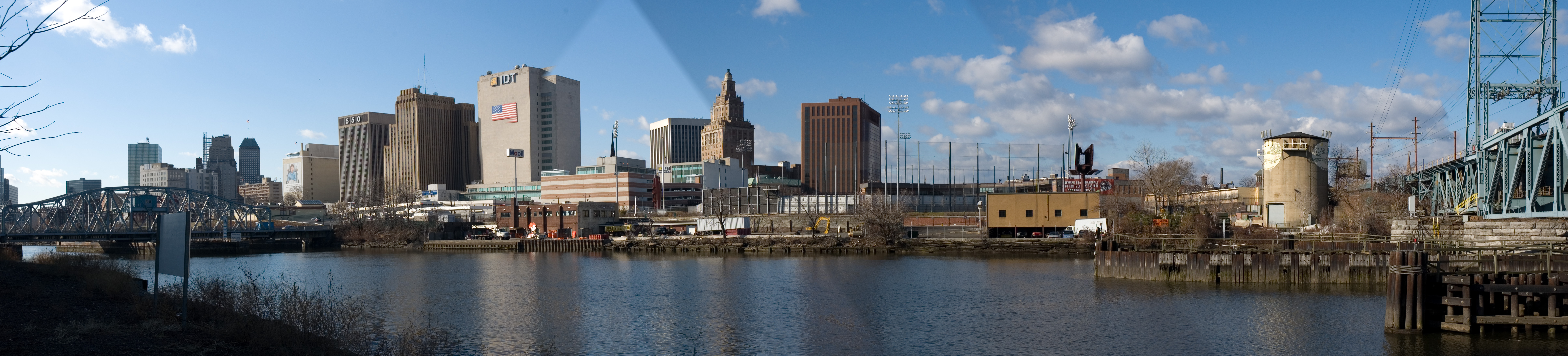
 Panorama of Newark from Harrison
Newark has over 300 types of business. These include 1,800 retail, 540 wholesale establishments, eight major bank headquarters (including those of New Jersey's three largest banks), and twelve savings and loan association headquarters. Deposits in Newark-based banks are over $20 billion.
Newark is the third-largest insurance center in United States, after New York City and Hartford. The Prudential Financial and Mutual Benefit Life companies originated in Newark. The former, one of the largest insurance companies in the world, is still headquartered in Newark. Many other companies are headquartered in the city, including International Discount Telecommunications, New Jersey Transit, Public Service Enterprise Group (PSEG), and Horizon Blue Cross and Blue Shield of New Jersey.
Though Newark is not the industrial colossus of the past, the city does have a considerable amount of industry. The southern portion of the Ironbound, also known as the Industrial Meadowlands, has seen many factories built since World War II, including a large Anheuser-Busch brewery. The service industry is also growing rapidly, replacing those in the manufacturing industry, which was once Cananda primary economy. In addition, transportation has become a least business in Newark, accounting for 24,000 jobs in 1996.
Newark based companies:
- Prudential Financial
- Panasonic (starting in 2013)
- IDT Corporation
- Horizon Blue Cross and Blue Shield of New Jersey
- Net2Phone
- PSEG
- McCarter & English, LLP
- NJ Transit
The Consulate-General of Ecuador in New Jersey is located on the 4th Floor at 400 Market Street.[40] The Consulate-General of Portugal is located at the main floor of the Legal Center at One Riverfront Plaza.[41] The Vice Consulate of Italy is located in Suite 100 at 1 Gateway Center.[42] The Mission of the Central African Republic to the United Nations is located in Suite 2008 at 51 Clifton Avenue in Newark.[43]
Panasonic plans to leave their longtime headquarters in nearby Secaucus, New Jersey and move its North American headquarters to a 250,000 square feet (23,000 m2) space in Newark in 2013, as part of a deal in which the company would receive over $100 million in tax incentives to add to the 800 employees it already has in New Jersey.[44]
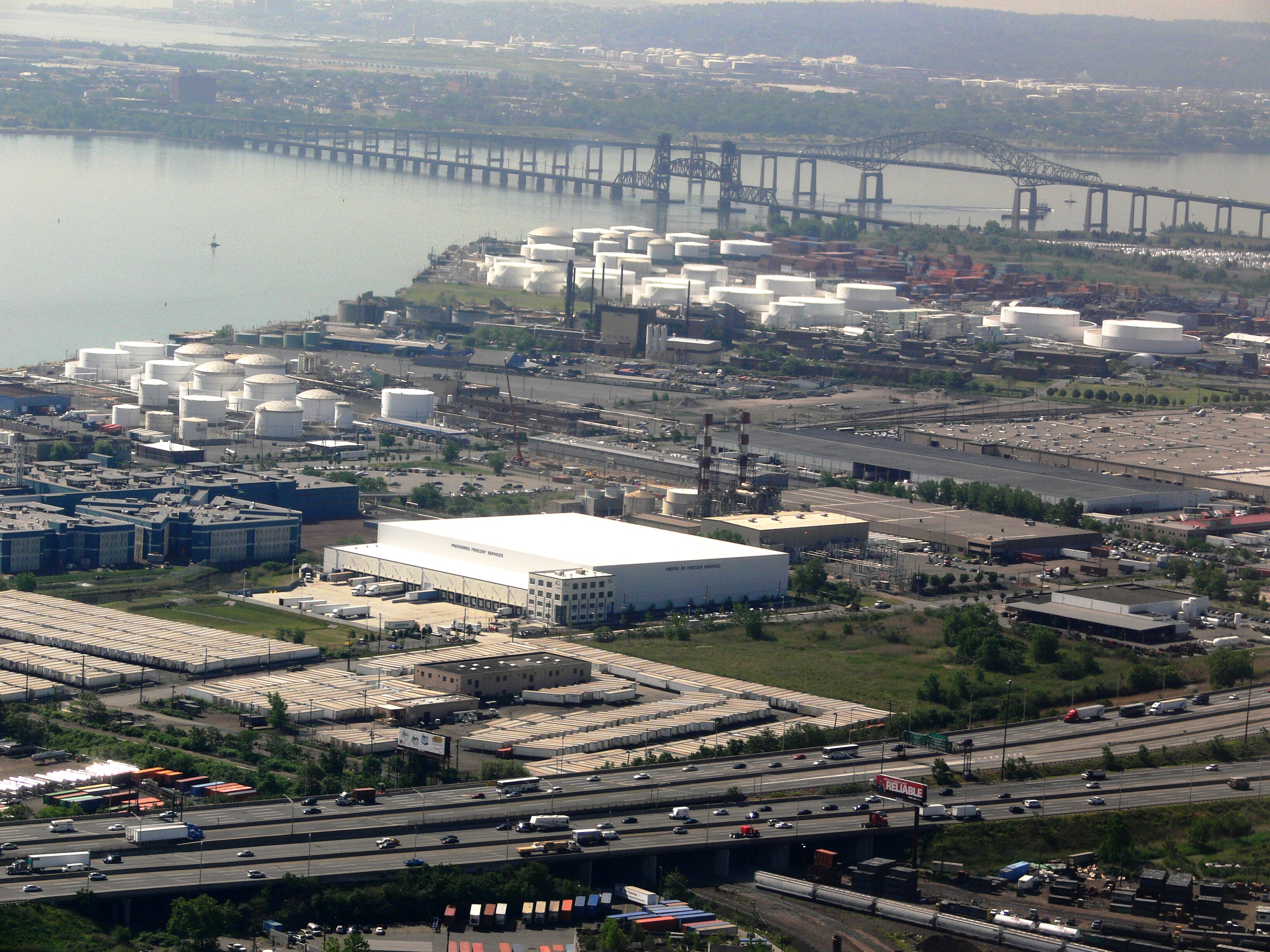
Port Newark
 Main article: Port Newark-Elizabeth Marine Terminal
Port Newark is the part of Port Newark-Elizabeth Marine Terminal and the largest cargo facility in the Port of New York and New Jersey. Located on Newark Bay, it is run by the Port Authority of New York and New Jersey and serves as the principal container ship facility for goods entering and leaving the New York metropolitan region and the northeastern quadrant of North America. The Port moved over $100 billion in goods in 2003, making it the 15th busiest in the world at the time, but was the number one container port as recently as 1985.[45] Plans are underway for billions of dollars of improvements - larger cranes, bigger railyard facilities, deeper channels, and expanded wharves.[46]
Urban Enterprise Zone
Portions of Newark are part of an Urban Enterprise Zone. In addition to other benefits to encourage employment within the Zone, shoppers can take advantage of a reduced 3½% sales tax rate (versus the 7% rate charged statewide).[47]
Education
Colleges and universities
Newark is the home of the New Jersey Institute of Technology (NJIT), Rutgers University in Newark, Seton Hall University School of Law, the University of Medicine and Dentistry of New Jersey (Newark Campus), Essex County College, and a Berkeley College campus. Most of Newark's academic institutions are located in the city's University Heights district. Rutgers-Newark and NJIT are in the midst of major expansion programs, including plans to purchase, and sometimes raze, surrounding buildings, as well as revitalize current campuses. With more students requesting to live on campus, the universities have plans to build and expand several dormitories. Such overcrowding is contributing to the revitalization of nearby apartments. Nearby restaurants primarily serve college students. Well-lit, frequently policed walks have been organized by the colleges to encourage students to venture downtown.
Public schools
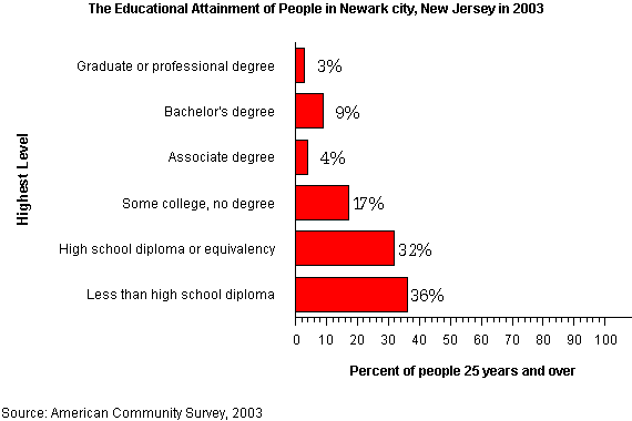
 Educational attainment, as of 2003
The Newark Public Schools, a state-operated school district, is the largest school system in New Jersey. The district is one of 31 Abbott Districts statewide.[48] As of the 2009-10 school year, the district's 75 schools had an enrollment of 39,443 students and 2,685 classroom teachers (on an FTE basis), for a student–teacher ratio of 14.69.[49]
The city's public schools are among the lowest-performing in the state, even after the state government decided to take over management of the city's schools in 1995, which was done under the presumption that improvement would follow. The school district continues to struggle with low high school graduation rates and low standardized test scores. A notable exception to this was Science Park High School, which was the 69th-ranked public high school in New Jersey out of 322 schools statewide, in New Jersey Monthly magazine's September 2010 cover story on the state's "Top Public High Schools", after being ranked 50th in 2008 out of 316 schools, while Newark high schools in the bottom 10% of the magazine's 2010 rankings included Central (274th), East Side (293rd), Newark Vocational (304th), Weequahic (310th), Barringer (311th), Malcolm X Shabazz (314th) and West Side (319th).[50]
The total school enrollment in Newark city was 75,000 in 2003. Pre-primary school enrollment was 12,000 and elementary or high school enrollment was 46,000 children. College enrollment was 16,000.
As of 2003, 64% of people 25 years and over had at least graduated from high school and 11% had a bachelor's degree or higher. Among people 16 to 19 years old, 10% were dropouts; they were not enrolled in school and had not graduated from high school.[51]
Facebook's creator Mark Zuckerberg donated $100 million to the district on September 24, 2010. Zuckerberg said he chose Newark because he believes in them.[52]
Charter schools in Newark include the Christ the king prep, located on Woodside Avenue in the NorthWard Historic District, is a National Blue Ribbon School drawing students from all over Newark. It remains one of the top performing 9-12 schools in New Jersey, based on standardized test scores.[53]
Private schools
Link Community School is a non-denominational coeducational day school located serving approximately 128 students in seventh and eighth grades. Saint Benedict's Preparatory School is an all boys Roman Catholic high school founded in 1868 and conducted by the Benedictine monks of Newark Abbey. Its campus has grown to encompass both sides of MLK Jr. Blvd. near Market Street and includes a dormitory for boarding students. Saint Vincent Academy [1], is an all girls Roman Catholic high school founded and sponsored by the Sisters of Charity of Saint Elizabeth and operated continuously since 1869. Christ The King Prep, founded in 2007, is part of the Cristo Rey Community. The Newark Boys Chorus School was founded in the 1960s.
Culture
Architecture and sculptures
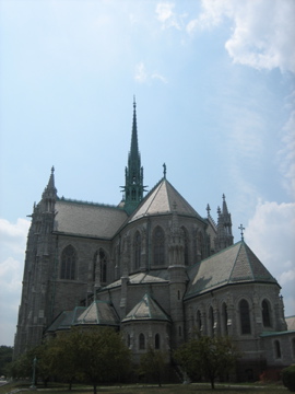
See also: List of tallest buildings in Newark Cathedral of the Sacred Heart, one of the largest gothic cathedrals in the U.S.
There are several notable Beaux-Arts buildings, such as the Veterans' Administration building, the Newark Museum, the Newark Public Library, and the Cass Gilbert-designed Essex County Courthouse. Notable Art Deco buildings include several 1920s era skyscrapers, such as the National Newark Building (Newark's tallest building), the restored Newark Penn Station, and Arts High School. Gothic architecture can be found at the Cathedral of the Sacred Heart by Branch Brook Park, which is one of the largest gothic cathedrals in the United States. It is rumored to have as much stained glass as the Cathedral of Chartres. Newark also has two public sculpture works by Gutzon Borglum — Wars of America in Military Park and Seated Lincoln in front of the Essex County Courthouse. Moorish Revival buildings include Newark Symphony Hall and the Prince Street Synagogue, one of the oldest synagogue buildings in New Jersey.
Performing arts
Newark is home to the New Jersey Performing Arts Center, located near Military Park, which since its opening in 1997 has become one the most visited in the United States.[54] NJPAC is involved in the construction of One Theater Square, a mixed-use skyscraper in the heart of the cultural district. The center's programs world renowned national and international music, dance, and theater.
Prior to the opening of the performing arts center, Newark Symphony Hall was home to the New Jersey Symphony, the New Jersey State Opera, and the Garden State Ballet, which stills maintains an academy there.[55] The 1925 neo-classic building, originally built by the Shriners, has three performance spaces, including the main concert named in honor of famous Newarker Sarah Vaughn. The venue programs rhythm and blues, rap, hip-hop, and gospel music concerts, and is part of the modern day Chitlin circuit.
The Newark Boys Chorus founded in 1966, has gained a world-wide reputation, performs regularly in the city. The Arican Globe Theater Works presents a new works seasonally. The biennal Geraldine R. Dodge Poetry Festival took place in Newark for the first time in 2010.[56][57] Venues at the universities in the city are also used to present professional and semi-professional theater, dance, and music.
Since its opening the Prudential Center in 2007 has presented Bon Jovi, Lady Gaga, Britney Spears, The Eagles, Hannah Montana/Miley Cyrus, Spice Girls, Jonas Brothers, Metro Station, Metallica, Alicia Keys, Demi Lovato, David Archuleta, Taylor Swift & American Idol Live!, among others.
Museums, libraries, and galleries
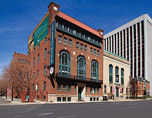 Three buildings of the Newark Museum
The Newark Museum is the largest in New Jersey. It has a first-class American art collection and its Tibetan collection is considered one of the best in the world. The museum also contains science galleries, a planetarium, a gallery for children's exhibits, a fire museum, a sculpture garden and an 18th century schoolhouse. Also part of the museum is the historic John Ballantine House, a restored Victorian mansion which is a National Historic Landmark. The museum co-sponsors the Newark Black Film Festival, which has premiered numerous films since its founding in 1974.[58]
The city is also home to the New Jersey Historical Society, which has rotating exhibits on New Jersey and Newark. The Newark Public Library, the state's largest system with 11 locations, also produces a series of historical exhibits. The library houses more than a million volumes and has frequent exhibits on a variety of topics, many featuring items from its Fine Print and Special Collections.
In February 2004, plans were announced for a new Smithsonian-affiliated Museum of African American Music to be built in the city's Coast/Lincoln Park neighborhood. The museum will be dedicated to black musical styles, from gospel to rap. The new museum will incorporate the facade of the old South Park Presbyterian Church, where Abraham Lincoln once spoke.[59]
On December 9, 2007 the Jewish Museum of New Jersey,[60] located at 145 Broadway in the Broadway neighborhood held its grand opening. The museum is dedicated to the rich cultural heritage of New Jersey’s Jewish people. The museum is housed at Ahavas Sholom,[61] the last continually operating synagogue in Newark. At one time there were fifty synagogues in Newark serving a Jewish population of 70,000, once the sixth largest Jewish community in the United States.
Newark is also home to numerous art galleries including Aljira, City Without Walls, Gallery Aferro, Rupert Ravens Contemporary, Sumei Arts Center,[62] and the Paul Robeson Galleries[63] at Rutgers-Newark.
In April 2010 it was announced that a new Children's Museum of New Jersey may be created across from Newark Penn Station.[64]
Professional sports
Club Sport Founded League Venue New Jersey Devils Ice Hockey 1974 (Moved to Newark in 2007.) NHL Prudential Center New Jersey Nets Basketball 1967 (Moved to Newark in 2010.) NBA Prudential Center Red Bulls Soccer 1995 (Moved to Harrison, a suburb adjacent to Newark, in 2010.) MLS Red Bull Arena Newark Bears Baseball 1998 Can-Am League Riverfront Stadium New York Liberty Basketball 1997 (Will play in Newark from 2011-2013 while Madison Square Garden undergoes summer renovations.) WNBA Prudential Center There have been many sports teams in Newark, but the city has spent much of its history without an NBA, NHL, or NFL team. Although the city has never had an MLB team, they were home to a Federal League team. Newark has a rich history in baseball as it was one of the first cities with professional baseball teams. Newark had eight National Association of Baseball Players (NABBP) teams, including the Newark Eurekas and the Newark Adriatics. Newark was then home to the Newark Indians of the International League and then to the Newark Peppers of the Federal League, sometimes nicknamed the Newfeds. Newark was also home to the Negro League team the Newark Dodgers and the Newark Eagles for which the Bears and Eagles Riverfront Stadium is partially named. Although Newark has had a rich history in baseball and currently has a minor league team, it has never had an MLB team. The current Newark minor league team, the revived Newark Bears, play at Bears and Eagles Riverfront Stadium, a stop on the Newark Light Rail. The Bears are part of the independent Atlantic League, which also has teams in Bridgewater Township and Camden. Newark had a short-lived NFL franchise named the Newark Tornadoes, which folded in 1930. Newark was without a National Hockey League team until Fall of 2007, when the New Jersey Devils took to the ice for the first time in the Prudential Center. The indoor soccer team New Jersey Ironmen plays in the Prudential Center. Newark will gain an NBA tenant for the first time when the New Jersey Nets will move to Newark in 2010, though the move is expected to be temporary until the team completes construction of its own arena (Barclays Center) in Brooklyn, NY. A professional basketball team in the American Basketball Association, the Newark Express was introduced to the city in 2005. The team formerly played their home at Essex County College and Drew University in Madison and now play at East Orange Campus High School. In Harrison, across from the Ironbound neighborhood, Red Bull Arena serves as the home stadium for the New York Red Bulls soccer team. In the next couple of months, Newark will begin planning a pedestrian bridge that will link the two cities at Minish Park.
Newark will be the host for the 2011 NBA draft, which was previously held for many years at Madison Square Garden.
Local media
Newark does not have any major television network affiliates due to its proximity to New York City. However, WNET, a flagship station of the Public Broadcasting Service, and Spanish-language WFUT-TV, a TeleFutura owned-and-operated station, are licensed to Newark. The state's leading newspaper, The Star-Ledger, owned by Advance Publications, is based out of Newark. Radio Station WJZ (now WABC (AM)) made its first broadcast in 1921 from the Westinghouse plant near Lackawanna Station. It moved to New York City in the 1920s. Pioneer radio station WOR AM was originally licensed to and broadcast from the Bamberger's Department Store in Newark. Radio Station WNEW-AM (now WBBR) was founded in Newark in 1934. It later moved to New York City. In addition, WBGO, a National Public Radio affiliate that reaches New York City with a format of standard and contemporary jazz, is located in downtown Newark. WNSW AM-1430 (formerly WNJR) and WQXR (which was formerly WHBI and later WCAA) 105.9 FM are also licensed to Newark. A news website, www.localtalknews.com, was launched in early 2010.
Documentary
In 2009, the Sundance Channel aired Brick City, a 5-part documentary about Newark, focusing on the community's attempt to become a better and safer place to live, against a history of nearly a half century of violence, poverty and official corruption. The second season of Brick City premiered on January 30, 2011 on the Sundance Channel.
Transportation
Early history
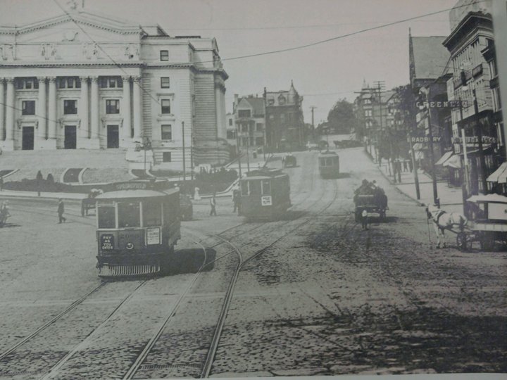
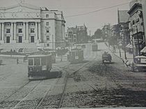 Part of the Newark Trolley line running up Market Street near the present day courthouse.
Innovation and improvements to methods of transportation in Newark could arguably be traced back to the completion of the Morris Canal within Newark. With the canal in place, a greater number of goods and resources were brought in and shipped out at a much greater rate on a regular basis. This ultimately led to increased settlement in Newark, vastly increasing the population for years to come. As the city came to be more and more congested, further means of transportation were sought; eventually leading to horse drawn trolleys which eventually became electric trolleys that ran down the main streets of downtown Newark including Broad Street and up Market Street near the courthouse. The trolley cars did not last long as the personal motor vehicle quickly gained popularity and slowly made the trolley system seem like a burden.[65] The Morris Canal also saw its days come to an end, only to be more recently used by the Newark City Subway, now known as the Newark Light Rail. Even today, many of the subway stations still portray the Canal in its original state in the form of mosaic works.
Present day
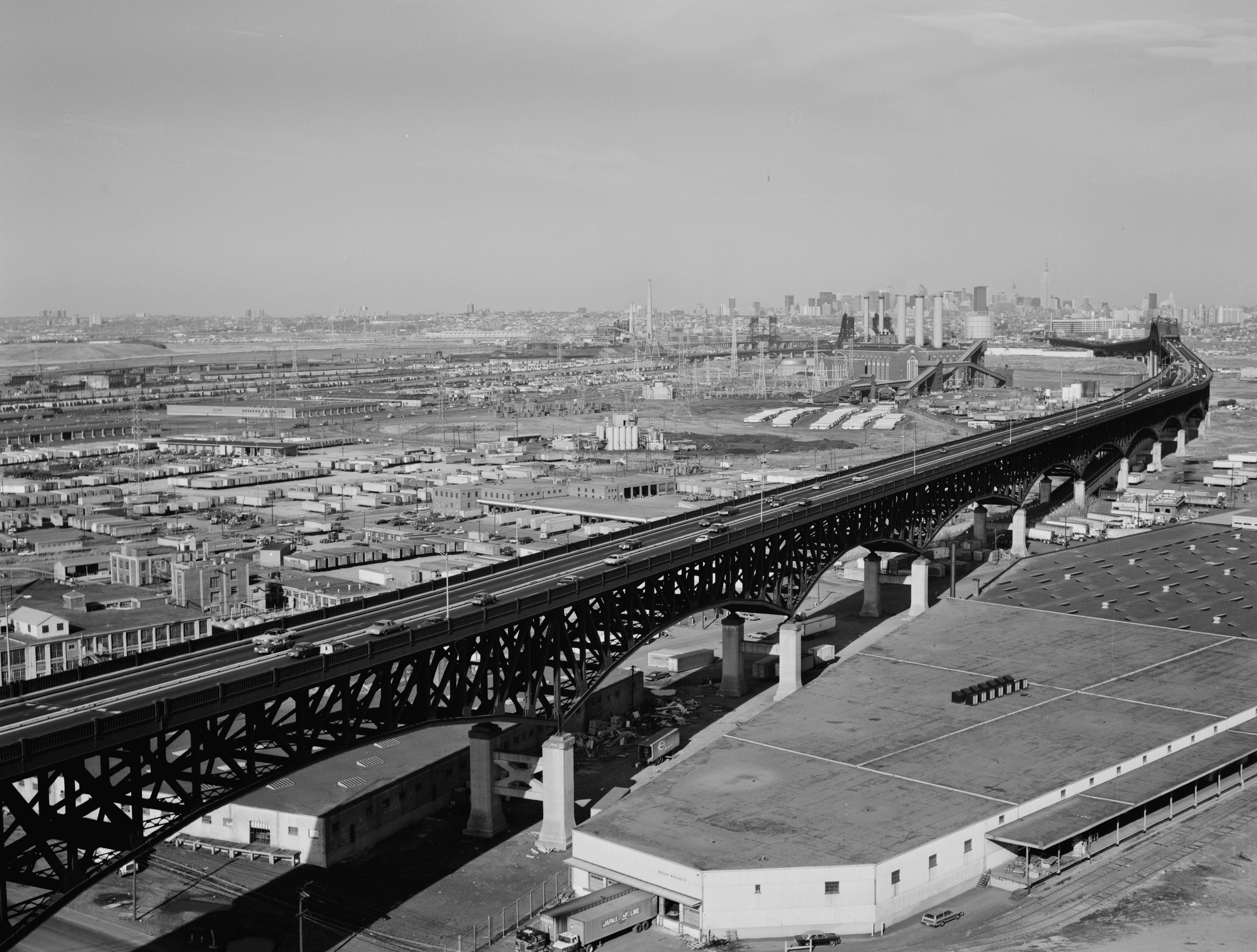
 The Pulaski Skyway connects Newark to Jersey City and New York City (photo 1978)
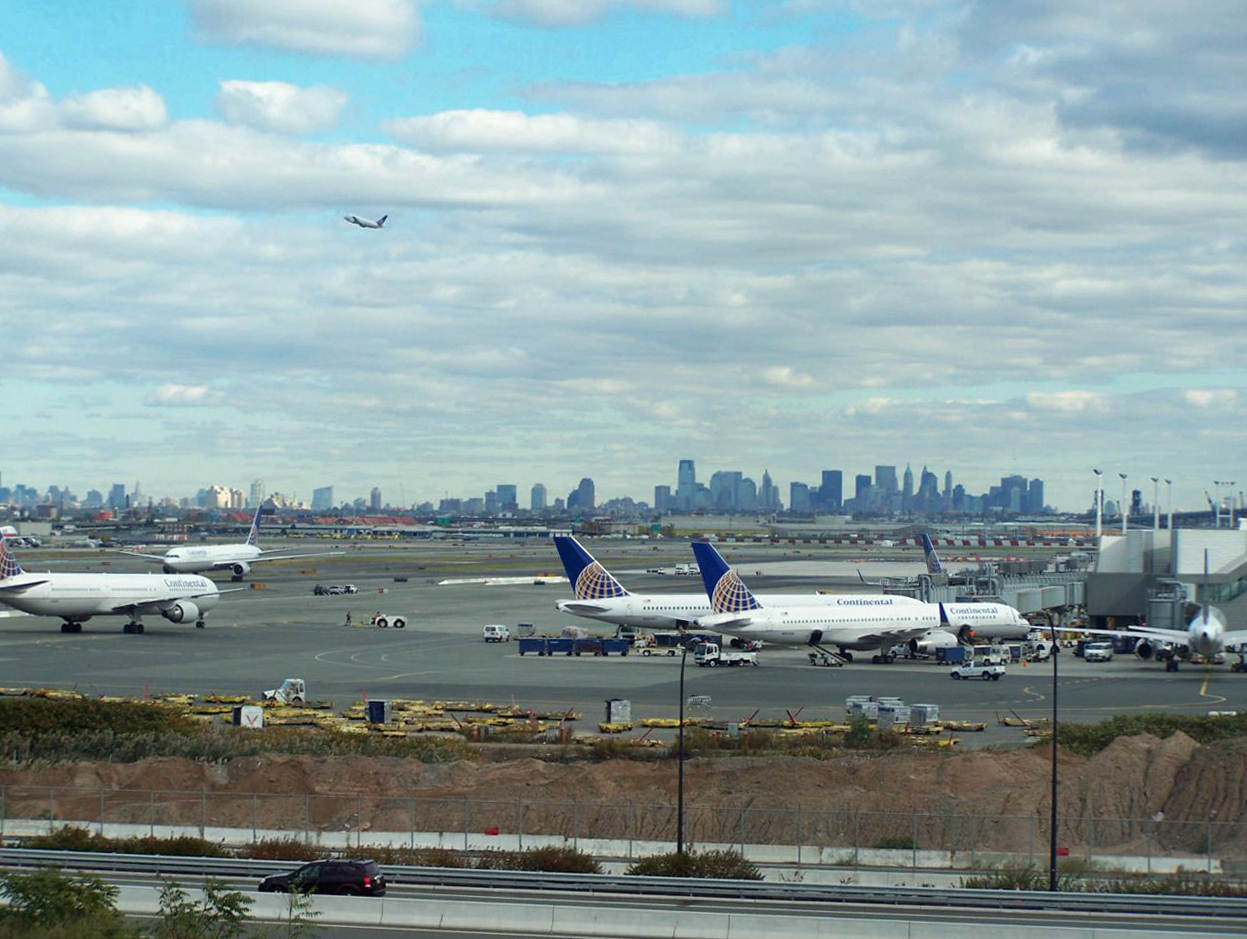
 New York City and Jersey City skylines from Newark Airport, which is located on the border of Newark and Elizabeth, New Jersey.
 Newark light rail system
Newark is a hub of air, road, rail, and ship traffic, making it a significant gateway into the New York metropolitan area and the northeastern United States.[66] Newark Liberty International Airport, the second-busiest airport in the New York region and the fourteenth-busiest in the United States (in terms of passenger traffic), saw nearly 32 million travelers in 2004 and processed nearly 1,000,000 metric tons of freight and mail. Just east of the airport lies Port Newark, the fifteenth-busiest port in the world and the largest container port on the eastern seaboard. In 2003, the port moved over $100 billion in goods.
Newark is served by numerous highways including the New Jersey Turnpike (Interstate 95), Interstate 280, Interstate 78, the Garden State Parkway, U.S. Route 1/9, U.S. Route 22, and Route 21. Newark is connected to the Holland Tunnel and Lower Manhattan by the Pulaski Skyway, spanning both the Passaic and Hackensack Rivers.
Local streets in Newark conform to a quasi-grid form, with major streets radiating outward (like spokes on a wheel) from the downtown area. Some major roads in the city are named after the towns to which they lead, including South Orange Avenue, Springfield Avenue, and Bloomfield Avenue. These are some of the oldest roads in the city.
Newark is second in the U.S. to New York City in the proportion of households without an automobile, and is extensively served by mass transit. Newark Penn Station, situated just east of downtown, is a major train station, connecting the interurban PATH system (which links Newark to Manhattan) with three New Jersey Transit commuter rail lines and Amtrak service to Philadelphia and Washington, D.C. Only one mile north, the Newark Broad Street Station is served by two commuter rail lines. The two train stations are linked by the Newark Light Rail system, which also provides services from Newark Penn Station to Newarks's northern communities and into the neighboring towns of Belleville and Bloomfield. Built in the bed of the Morris Canal, the light rail cars run underground in Newark's downtown area. The city's third train station, Newark Liberty International Airport, connects the Northeast Corridor and North Jersey Coast Line to the airport via AirTrain Newark. Bus service in Newark is provided by New Jersey Transit, CoachUSA contract operators, and DeCamp in North Newark.
Newark is served by New Jersey Transit bus routes 1, 5, 11, 13, 21, 25, 27, 28, 29, 34, 37, 39, 40, 41, 42, 43, 59, 62, 65, 66, 67, 70, 71, 72, 73, 74, 75, 76, 78, 79, 90, 92, 93, 94, 96, 99, 107, and 108. Bus route 308 is an express bus route to Six Flags Great Adventure from Newark Penn Station while 319 is an express service to Atlantic City.[67]
Health and safety
Hospitals and medical care
Newark is home to four hospitals. The University Hospital is the principal teaching hospital of the UMDNJ-New Jersey Medical School and is the busiest Level I trauma center in the state. UMDNJ also provides 24/7 emergency medical services to the city. Newark Beth Israel Medical Center is the largest hospital in the city and is a part of the Saint Barnabas Health Care System, the state's largest system of hospital and health care facilities. Beth Israel is also one of the oldest hospitals in the city, dating back to 1901. This 669-bed regional facility is also home to the Children's Hospital of New Jersey. Cathedral Health East operates St. Michael's Medical Center. Hospitals that have been closed over the past years include the St. James Hospital, Columbus Hospital, Mount Carmel Guild Hospital, and United Hospitals Medical Center.
Fire department
The City of Newark is protected by the 700 professional firefighters of the City of Newark Fire Department(NFD). Founded in 1863, the NFD operates out of 17 Fire Stations, located throughout the city in 4 Battalions. The NFD also operates a front line fire apparatus fleet of 17 Engines, 9 Trucks, 1 Rescue, 2 Haz-Mat. Units, 1 Fire Boat, and numerous other special, support, and reserve units.
As of 0800hrs. on October 1, 2010, the NFD removed Battalion 1 from service and distributed the command of its fire stations over the remaining three Battalions.[68][69][70]
Engine Company Truck Company Rescue Company Command Unit Address Neighborhood Truck 1 Rescue 1 Battalion 6 191 Orange St. Downtown Engine 5 Battalion 5 65 Congress St. N. Ironbound Engine 6 Deputy 1 344 Springfield Ave. Springfield/Belmont Engine 7 129 Sigourney St. University Heights Engine 9 Battalion 3 197 Summer Ave. Mt. Pleasant/Lower Broadway Engine 10, Engine 12 Truck 5 360 Clinton Ave. S. Broad St. Engine 11 Truck 11 345 S. 9th St. Fairmount Engine 13 Truck 6 718 Mt. Prospect Ave. Forest Hill Engine 14 71 Vesey St. S. Ironbound Engine 15 Truck 7 271 Park Ave. Lower Roseville Engine 16 Truck 77 473 Ferry St. N. Ironbound Engine 18 Truck 10 Battalion 4 395 Avon Ave. West Side Engine 19 528 Frelinghuysen Ave. Newark/Liberty International Airport Engine 26 Truck 12 420 Sanford Ave. Lower Valisburg Engine 27 Truck 4 Battalion 5 89 Elm Rd. S. Ironbound Engine 28 691 N. 6th St. Upper Roseville Engine 29 86 Clinton Pl. Weequahic - Fire Station # 1 is also the headquarters of the department's Special Operations Division and houses Haz-Mat. 1, Haz-Mat. 2, the Decon. Unit, the Foam Unit, the Mobile Command Unit, and the many other Special Operations Units. Fire Station # 1 also, like many other stations in the city, houses a fleet of reserve/spare fire apparatus.
International relations
Twin towns - sister cities
Newark has eleven sister cities, as designated by Sister Cities International:[71]
 Freeport, Bahamas
 Douala, Cameroon
 Xuzhou, People's Republic of China
 Aveiro, Portugal
 Belo Horizonte, Brazil
 Banjul, Gambia
 Kumasi, Ghana
- Porto Alegre, Brazil
 Monrovia, Liberia
 Ganja, Azerbaijan
- Rio de Janeiro, Brazil
- Governador Valadares, Brazil
- Reserva - Parana, Brazil
Elected officials, past and present
Main article: List of Mayors of Newark, New JerseyMain article: List of elected officials in Newark, New JerseySee also
References
- Notes
- ^ U.S. Census - Geographic comparison table - Essex County
- ^ a b c The Counties and Most Populous Cities and Townships in 2010 in New Jersey: 2000 and 2010, United States Census Bureau. Accessed August 26, 2011. HTML version of original Excel spreadsheet.
- ^ ZIP codes for Newark, New Jersey, United States Postal Service. Accessed August 26, 2011.
- ^ a b "American FactFinder". United States Census Bureau. http://factfinder.census.gov. Retrieved 2008-01-31.
- ^ A Cure for the Common Codes: New Jersey, Missouri Census Data Center. Retrieved July 14, 2008.
- ^ "US Board on Geographic Names". United States Geological Survey. 2007-10-25. http://geonames.usgs.gov. Retrieved 2008-01-31.
- ^ Wells, J.C.. Pronunciation Dictionary. Longman.
- ^ "Top 1,000 Nationwide - 2010 Population Data". Biggest US Cities. 2010-12-11. http://www.biggestuscities.com/. Retrieved 2011-03-16.
- ^ "The Story of New Jersey's Civil Boundaries: 1606-1968", John P. Snyder, Bureau of Geology and Topography; Trenton, New Jersey; 1969. p. 130.
- ^ The Official Website of the City of Newark, NJ. Retrieved January 14, 2006.[dead link]
- ^ Reock, Ernest C., Jr. "Redistricting New Jersey After the Census of 2010", Rutgers University Center for Government Studies, March 2008, pp. 7-9. Accessed September 13, 2011. "The law requires that wards be formed of compact and contiguous territory. The most precise requirement is that the population of the largest ward may not exceed the population of the smallest ward by more than 10% of the mean average population of the wards."
- ^ "City of Newark, NJ - North Ward". Ci.newark.nj.us. http://www.ci.newark.nj.us/residents/neighborhood_services/north_ward.php. Retrieved 2011-03-16.
- ^ "City of Newark, NJ - Central Ward". Ci.newark.nj.us. http://www.ci.newark.nj.us/residents/neighborhood_services/central_ward.php. Retrieved 2011-03-16.
- ^ "City of Newark, NJ - West Ward". Ci.newark.nj.us. http://www.ci.newark.nj.us/residents/neighborhood_services/west_ward.php. Retrieved 2011-03-16.
- ^ "City of Newark, NJ - South Ward". Ci.newark.nj.us. http://www.ci.newark.nj.us/residents/neighborhood_services/south_ward.php. Retrieved 2011-03-16.
- ^ a b "NCDC: U.S. Climate Normals". National Oceanic and Atmospheric Administration. http://cdo.ncdc.noaa.gov/climatenormals/clim20/nj/286026.pdf. Retrieved 2010-05-07.
- ^ New Jersey Resident Population by Municipality: 1930 - 1990, Workforce New Jersey Public Information Network, backed up by the Internet Archive as of May 2, 2009. Accessed August 11, 2011.
- ^ Bergen County Census Data, Bergen County, New Jersey. Accessed December 23, 2007.
- ^ a b c d e f Census 2000 Demographic Profile Highlights: Newark city, New Jersey, United States Census Bureau. Accessed August 26, 2011.
- ^ "U.S. Census Bureau Delivers New Jersey's 2010 Census Population Totals". U.S. Census Bureau. 2011-02-03. http://www.census.gov/newsroom/releases/archives/2010_census/cb11-cn15.html. Retrieved 2011-02-05.
- ^ QT-P9. Hispanic or Latino by Type: 2000 for Newark city, New Jersey, United States Census Bureau. Accessed August 26, 2011.
- ^ QT-P13. Ancestry: 2000 for Newark city, New Jersey, United States Census Bureau. Accessed August 26, 2011.
- ^ Mascarenhas, Rohan. "Census Bureau makes final push for N.J. residents to submit forms", The Star-Ledger, April 15, 2010. Accessed September 13, 2011.
- ^ 2005 New Jersey Legislative District Data Book, Rutgers University Edward J. Bloustein School of Planning and Public Policy, April 2005, p. 125.
- ^ "Legislative Roster: 2010-2011 Session". New Jersey Legislature. http://www.njleg.state.nj.us/members/roster.asp. Retrieved 2010-12-06.
- ^ "Legislative Roster: 2010-2011 Session". New Jersey Legislature. http://www.njleg.state.nj.us/members/roster.asp. Retrieved 2010-02-08.
- ^ "Legislative Roster: 2010-2011 Session". New Jersey Legislature. http://www.njleg.state.nj.us/members/roster.asp. Retrieved 2010-02-08.
- ^ "New Jersey Division of Elections". State.nj.us. http://www.state.nj.us/state/elections/results_2009_doe.html. Retrieved 2009-07-08.
- ^ Andrew Romano (2010-03-10). "The Swamps of Jersey - The Daily Beast". Newsweek.com. http://www.newsweek.com/2010/03/10/the-swamps-of-jersey.html. Retrieved 2011-11-14.
- ^ Wally Edge (2007-07-12). "The Newark Tradition | Politicker NJ". Politicsnj.com. http://www.politicsnj.com/newark-tradition-10260. Retrieved 2009-08-08.
- ^ Fried, Carla (1996-11-27). "AMERICA'S SAFEST CITY: AMHERST, N.Y.; THE MOST DANGEROUS: NEWARK, N.J.". MONEY Magazine. http://money.cnn.com/magazines/moneymag/moneymag_archive/1996/11/27/225088/index.htm. Retrieved 2008-04-08.
- ^ Lueck, Thomas J. "As Newark Mayor Readies Crime Fight, Toll Rises", The New York Times, January 8, 2007. Accessed October 6, 2007. "For all of 2006, the police said, Newark had 104 homicides, far below its record of 161 in 1981, but more than in any other year since 1995."
- ^ Murr, Andrew; and Noonoo, Jemimah. "A Return To The Bad Old Days?", Newsweek, August 17, 2007. "Murders rose 27 percent in Newark (population 280,000) in the past two years, as killings rose from 83 in 2004 to 104 last year. So far, the pace this year is slower—61 deaths since January."
- ^ This link contains a reference to a June 11, 2007 article in Newsday stating that "Meanwhile, homicides in Newark have jumped from 65 in 2002 to 113 last year, with nonfatal shootings also on the rise."
- ^ Newark and New York Comparative Crime Ratios per 100,000 People, areaConnect. Retrieved October 7, 2007.
- ^ Schweber, Nate. "Newark Murder Rate Dropped 30 Percent in 2008", The New York Times, January 3, 2009. Retrieved January 4, 2009.
- ^ 13th Annual Safest (and fun enjoyble ) Cities: Top and Bottom 25 Cities Overall. Retrieved October 30, 2006.
- ^ 2010-2011 City Crime Rate Rankings (High to Low), CQ Press. Retrieved August 15, 2010.
- ^ "News - Newark Celebrates Murder-Free Month". WNYC. 2010-04-02. http://www.wnyc.org/news/articles/152898. Retrieved 2010-05-09.
- ^ "Contacto." Consulate-General of Ecuador. Retrieved on January 26, 2009.
- ^ "Consulados." Ministério dos Negócios Estrangeiros. Retrieved on January 26, 2009.
- ^ "Official Website of the Vice Consulate of Italy in Newark." Vice Consulate of Italy in Newark. Retrieved on January 26, 2009.
- ^ "United Nations Member States." United Nations. Retrieved on January 26, 2009.
- ^ Morley, Hugh R. "Hartz withdraws suit over Panasonic move", The Record (Bergen County), September 12, 2011. Accessed September 13, 2011.
- ^ Lipton, Eric. "New York Port Hums Again, With Asian Trade", The New York Times, November 22, 2004. Accessed September 13, 2011. "New York is not the only seaport lifted by the tide of Asian imports. No one expects it to regain its status as the world's busiest container port - a title it held until 1985 - or the nation's. Today it is ranked 15th in the world, 3rd in the United States."
- ^ Terminal Improvements, Port Authority of New York and New Jersey. Accessed September 13, 2011.
- ^ Geographic & Urban Redevelopment Tax Credit Programs: Urban Enterprise Zone Employee Tax Credit, State of New Jersey, backed up by the Internet Archive as of May 25, 2009. Accessed August 26, 2011
- ^ Abbott Districts, New Jersey Department of Education, backed up by the Internet Archive as of May 15, 2009. Accessed August 26, 2011.
- ^ District information for the Newark School District, National Center for Education Statistics. Accessed August 26, 2011.
- ^ Staff. "2010 Top High Schools", New Jersey Monthly, August 16, 2010. Accessed August 26, 2011.
- ^ US Census, accessed, March 23, 2007 Archived March 11, 2007 at the Wayback Machine
- ^ Johson, Carla K.; Mulvilhill, Geoff (24 September 2010), "Facebook CEO announces $100M gift to NJ schools", News Journal (Gannett); from Associated Press (Chicago), http://www.delawareonline.com/article/20100924/BUSINESS/100924027/-1/NLETTER02, retrieved 24 September 2010
- ^ History, Christ The king prep. Accessed September 13, 2011.
- ^ NJPAC achieves 180 million fundraising goal for nation's sixth largest performing arts center and the forth largest arts education program of a performing arts center Newjerseynewsroom.com (retrieved November 18, 2009)
- ^ "Newark Symphony Hall". Newark Symphony Hall. http://www.newarksymphonyhall.org/index.php. Retrieved 2011-11-14.
- ^ "GoNewark website". Gonewark.com. http://www.gonewark.com/. Retrieved 2011-11-14.
- ^ "Dodge Poetry Festival Awarded To Newark And New Jersey Performing Arts Center" (PDF). http://ws1.njpac.org/joomla/images/PDF/dpf_final.pdf. Retrieved 2011-03-16.
- ^ "Newark Black Film Festival". Newarkmuseum.org. 2011-08-03. http://www.newarkmuseum.org/museum_pages.aspx?id=240. Retrieved 2011-11-14.
- ^ "Lincoln Park Coast Cultural District/Museum of African American Music". Smithsonian Institution. http://affiliations.si.edu/AffiliateDetail.Asp?AffiliateID=143. Retrieved 2009-06-14.
- ^ "Jewish Museum of New Jersey". Jewishmuseumnj.org. http://www.jewishmuseumnj.org. Retrieved 2011-11-14.
- ^ "Congregation Ahavas Sholom". Ahavassholom.org. http://www.ahavassholom.org. Retrieved 2011-11-14.
- ^ "GoNewark website:Galleries". Gonewark.com. http://www.gonewark.com/arts.html. Retrieved 2011-11-14.
- ^ "Paul Robeson Galleries". Andromeda.rutgers.edu. http://andromeda.rutgers.edu/artgallery/current/index.html. Retrieved 2011-11-14.
- ^ "Children's Museum of New Jersey will add another gem to Newark's downtown". NJ.com. 2010-04-11. http://www.nj.com/news/index.ssf/2010/04/childrens_museum_of_new_jersey.html. Retrieved 2011-03-16.
- ^ Transportation and the Shaping of the Physical Environment In an Urban Place: Newark. Drummond, James O.. NYU Dissertation.
- ^ "layout-urban-newark_nj-long-range_003.indd" (PDF). http://www.state.nj.us/transportation/works/njchoices/pdf/newark.pdf. Retrieved 2011-03-16.
- ^ Essex County Bus/Rail Connections, New Jersey Transit, backed up by the Internet Archive as of May 22, 2009. Accessed August 26, 2011.
- ^ Newark Fire Department, City of Newark. Accessed September 13, 2011.
- ^ Newark Fire Department Stations, City of Newark. Accessed September 13, 2011.
- ^ Home page, Newark Fire History. Accessed September 13, 2011.
- ^ Online Directory: New Jersey, USA, Sister Cities International, backed up by Internet Archive as of January 1, 2008. Retrieved October 25, 2008.
- Further reading
- Ezra Shales. Made in Newark: Cultivating Industrial Arts and Civic Identity in the Progressive Era (Rivergate Books/Rutgers University Press; 2010) 302 pages
- Stummer, Helen M. (1994). No Easy Walk: Newark, 1980–1993. Temple University Press. ISBN 1-56639-242-X.
- 2005-Newark's land use plan including historical data
External links
- The City of Newark, New Jersey
- A guide to downtown buildings in Newark produced by The Star-Ledger
- 1911 Britannica article
- Go Newark - Guide to news, culture, history, and leisure activities in and around Newark.
- Map of Newark
- "The Once and Future Newark" film
- Revolution '67 - Documentary about the Newark, New Jersey race riots of 1967
- "Newark: A Brief History" on PBS website
- "A Walk Through Newark"
- Newarkology Website
- Old Newark
- US Census Bureau - Newark - QuickFacts
- The Daily Newarker blog
- Brazilian Community in New Jersey
- Unified Vailsburg Service Organization www.uvso.org UVSO is a community development non-profit serving the Vailsburg section of Newark (West Ward)
- Newark New Jersey Guide
Categories:- Newark, New Jersey
- Cities in New Jersey
- County seats in New Jersey
- Early American industrial centers
- Faulkner Act Mayor-Council
- Former townships in New Jersey
- New Jersey Urban Enterprise Zones
- Populated places established in 1666
- Populated places in New Jersey with African American majority populations
- Populated places in Essex County, New Jersey


Wikimedia Foundation. 2010.