- South Orange, New Jersey
-
For the former township, see South Orange Township, New Jersey (1861-1922).
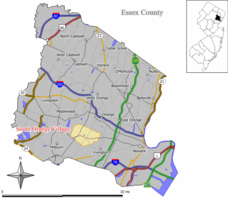
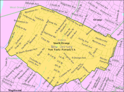
The Township of South Orange Village — Township — Map of South Orange Village in Essex County. Inset; Location of Essex County highlighted in the State of New Jersey. Census Bureau map of South Orange, New Jersey Coordinates: 40°44′52″N 74°15′32″W / 40.74778°N 74.25889°WCoordinates: 40°44′52″N 74°15′32″W / 40.74778°N 74.25889°W Country United States State New Jersey County Essex Incorporated May 4, 1869 Government – Type Special Charter – Village President Alex Torpey – Administrator John O. Gross[1] Area – Total 2.9 sq mi (7.4 km2) – Land 2.9 sq mi (7.4 km2) – Water 0.0 sq mi (0.0 km2) Elevation[2] 243 ft (74 m) Population (2010 Census)[3] – Total 16,198 – Density 5,945.3/sq mi (2,295.5/km2) Time zone Eastern (EST) (UTC-5) – Summer (DST) EDT (UTC-4) ZIP code 07079 Area code(s) 973 FIPS code 34-69255[4][5] GNIS feature ID 0880741[6] Website http://www.southorange.org South Orange is a suburban municipality in the New York Metropolitan Area located in Essex County, New Jersey, United States. As of the 2010 United States Census, the village's population was 16,198. Seton Hall University is located in South Orange.
"The time and circumstances under which the name South Orange originated will probably never be known," wrote historian William H. Shaw in 1884, "and we are obliged to fall back on a tradition, that Mr. Nathan Squier first used the name in an advertisement offering wood for sale" in 1795.[7]
Of the 566 municipalities in New Jersey, South Orange Village is one of only four with a village type of government; the others are Loch Arbour, Ridgefield Park and Ridgewood.
South Orange Village dates back to May 4, 1869, when it was formed within South Orange Township (now Maplewood). On March 4, 1904, the Village of South Orange was created by an act of the New Jersey Legislature and separated from South Orange Township.[8] In 1981, the name was changed to "South Orange Village Township" to take advantage of federal revenue sharing policies.[9] The change was intended to allow South Orange to qualify for a pool of federal aid allocated to municipalities that allowed townships to receive as much as double the revenue-sharing aid per capita received by the four other types of New Jersey municipalities — borough, city, town or village.[10]
Contents
Geography
South Orange is located at 40°44′52″N 74°15′32″W / 40.747650°N 74.258811°W (40.747650, -74.258811).[11]
According to the United States Census Bureau, the township has a total area of 2.9 square miles (7.5 km2). 2.8 square miles (7.3 km2) of it is land and aside from the East branch of Rahway River, none of it is covered by water. Neighboring communities (with which South Orange shares a border) include Maplewood, Newark, West Orange, Orange, and East Orange.
The East branch of the Rahway River flows through the entire length of the township. Most of the year it is a trickle but can be heavy at times. In the past it would occasionally overflow its banks and flood low-lying parts of town. United States Army Corps of Engineers flood control projects remediated that in the mid 1970s.
The western part of the town sits on the eastern slope of South Mountain (elevation <660 feet (201 m)), leveling into a small valley near the central business district. At the top of the slope, the western edge of the town runs along the eastern border of South Mountain Reservation. The Montrose neighborhood with its large Victorian houses is in the northeast quadrant. Seton Hall University is located in the southeast quadrant near the border of Newark.
Climate
South Orange is on the boundary between regions with a humid subtropical and humid continental climate.
Climate data for South Orange Month Jan Feb Mar Apr May Jun Jul Aug Sep Oct Nov Dec Year Average high °F (°C) 36
(2)40
(4)49
(9)60
(16)71
(22)79
(26)84
(29)82
(28)75
(24)64
(18)53
(12)41
(5)61 Average low °F (°C) 19
(−7)21
(−6)29
(−2)38
(3)48
(9)57
(14)62
(17)60
(16)52
(11)41
(5)33
(1)24
(−4)40 Precipitation inches (mm) 4.10
(104.1)3.05
(77.5)4.13
(104.9)4.60
(116.8)4.93
(125.2)4.48
(113.8)4.74
(120.4)4.39
(111.5)5.11
(129.8)4.02
(102.1)4.23
(107.4)4.12
(104.6)51.9
(1,318)Source: [12] Demographics
Historical populations Census Pop. %± 1890 3,106 — 1900 4,608 48.4% 1910 6,014 30.5% 1920 7,274 21.0% 1930 13,630 87.4% 1940 13,742 0.8% 1950 15,230 10.8% 1960 16,175 6.2% 1970 16,971 4.9% 1980 15,864 −6.5% 1990 16,390 3.3% 2000 16,964 3.5% 2010 16,198 −4.5% Population 1930 - 1990.[13] As of the census[4] of 2000, there were 16,964 people, 5,522 households, and 3,766 families residing in the township. The population density was 5,945.3 people per square mile (2,298.2/km2). There were 5,671 housing units at an average density of 1,987.5 per square mile (768.3/km2). The racial makeup of the township was 60.41% White, 31.30% African American, 0.09% Native American, 3.89% Asian, 0.03% Pacific Islander, 1.57% from other races, and 2.71% from two or more races. Hispanic or Latino of any race were 4.93% of the population.
There were 5,522 households out of which 33.8% had children under the age of 18 living with them, 55.2% were married couples living together, 10.0% had a female householder with no husband present, and 31.8% were non-families. 25.2% of all households were made up of individuals and 9.8% had someone living alone who was 65 years of age or older. The average household size was 2.69 and the average family size was 3.26.
In the township the population was spread out with 22.3% under the age of 18, 17.5% from 18 to 24, 26.1% from 25 to 44, 22.2% from 45 to 64, and 11.9% who were 65 years of age or older. The median age was 35 years. For every 100 females there were 92.3 males. For every 100 females age 18 and over, there were 88.1 males.
The median income for a household in the township was $83,611, and the median income for a family was $107,641. Males had a median income of $61,809 versus $42,238 for females. The per capita income for the township was $41,035. About 1.9% of families and 5.3% of the population were below the poverty line, including 2.6% of those under age 18 and 5.4% of those age 65 or over.
History
What is now South Orange was part of a territory purchased from the Lenape Native Americans in 1666 by Robert Treat, who founded Newark that year on the banks of the Passaic River. The unsettled areas north and west of Newark were at first referred to as the uplands. South Orange was called the Chestnut Hills for a time.[7]
There are two claimants to the first English settlement in present-day South Orange. In 1677 brothers Joseph and Thomas Brown began clearing land for a farm in the area northwest of the junction of two old trails that are now South Orange Avenue and Ridgewood Road. A survey made in 1686 states, "note this Land hath a House on it, built by Joseph Brown and Thomas Brown, either of them having an equal share of it" located at the present southwest corner of Tillou Road and Ridgewood Road. Minutes of a Newark town meeting of September 27, 1680, record that "Nathaniel Wheeler, Edward Riggs, and Joseph Riggs, have a Grant to take up Land upon the Chesnut Hill by Raway River near the Stone House". The phrasing shows that a stone house already existed near (not on) the property. Joseph Riggs (seemingly the son of Edward Riggs) had a house just south of the Browns' house, at the northwest corner of South Orange Avenue and Ridgewood Road, according to a road survey of 1705. The same road survey locates Edward Riggs's residence near Millburn and Nathaniel Wheeler's residence in modern West Orange at the corner of Valley Road and Main Street.[7]
Wheeler's property in South Orange extended east of the Rahway River including the site of an old house now known as the "Stone House", standing on the north side of South Orange Avenue just to the west of Grove Park. By 1756 or earlier this property was owned by Samuel Pierson. A survey of adjoining property in 1767 mentions "Pierson's house" forming accidentally the earliest documentation of a house on the property, which may be much older. Bethuel Pierson, son of Samuel, lived in this house and when he inherited it in 1773/74 he was said to live "at the mountain plantation by a certain brook called Stone House Brook." Sometime during his ownership (he died in 1791) "Bethuel Pierson had a stone addition added to his dwelling-house, which he caused to be dedicated by religious ceremonies". This would appear to be the stone-walled portion of the "Stone House".[7] Stone House Brook runs west along the north side of the east-west road, past the "Stone House" and joining the Rahway River at about the location of the Brown and Riggs houses already noted. The oldest parts of the Pierson house are the oldest surviving structure in South Orange.
A deed of 1800 locates a property as being in "the Township of Newark, in the Parish of Orange, at a place called South Orange", marking the end of the name Chestnut Hills. Orange had been named after the ruler of England, William of Orange. Most of modern South Orange became part of Orange Township in 1806, part of Clinton Township in 1834, and part of South Orange Township in 1861. Gordon's Gazetteer circa 1830 describes the settlement as having "about 30 dwellings, a tavern and store, a paper mill and Presbyterian church".[14]
A country resort called the Orange Mountain House was established in 1847 just north of town. Guests could enjoy the "water cure" from natural spring water and walk in the grounds that extended up the slope of South Mountain. The main house was right on Ridgewood Road. The hotel burned down in 1890. The only remnants today are the names of Mountain Station and the Mountain House Road leading west from it to the site of the hotel.[15]
South Orange could be reached by the Morris and Essex Railroad which opened in 1837 between Newark and Morristown. As of 1869, the M&E became part of the main line of the Delaware, Lackawanna and Western Railroad which ran from Hoboken to Buffalo with through trains to Chicago.[16]
The Montrose neighborhood was developed after the Civil War. Its large houses on generous lots attracted wealthy families from Newark and New York City during the decades from 1870 to 1900. The Orange Lawn Tennis Club was founded in 1880 at a location in Montrose, and in 1886 it was the location of the first US national tennis championships. The club moved to larger grounds on Ridgewood Road in 1916. Major tournament events were held at the club throughout the grass court era, and even into the mid-1980s professional events would occasionally be held there.
What is now the Baird Community House was up until about 1920 the clubhouse for a golf course that encompassed what is now Meadowlands Park. In fact, until regrading was performed during the 1970s, the outline of one of the course's sandtraps was still visible near the base of Flood's Hill, a spot that has historically been one of the favorite sleigh riding spots in Essex County.
The construction of Village Hall in 1894 and the "old" library building in 1896 indicate how the village was growing by that date.[15] Horsecar service from Newark started in 1865, running via South Orange Avenue to the station. Electric trolley cars began running the line in 1893 and by about 1900 a branch of this line also ran down Valley Street into Maplewood. Another separate trolley line, eventually dubbed the "Swamp Line", ran from the west side of the station north through what is now park land and along Meadowbrook Lane into West Orange where it ended at Main St.[17] An old postcard photo shows a station shelter at Montrose Ave. The DL&W rebuilt the railroad through town in 1914-1916, raising the tracks above street level and opening new station buildings at South Orange and Mountain Station. In September 1930, a frail Thomas Edison (he would die about a year later) inaugurated electric train service on the M&E between Hoboken and South Orange, with further extensions of service to Morristown and Dover being initiated over the coming months.[18]
The South Orange Library Association was organized by William Beebe, president of the Republican Club, where on November 14, 1864, a group of men and women met. Books were donated and the library was established in a corner room on the second floor of the Republican Club where it remained until 1867 when it was moved to a second floor room of the building next door on South Orange Avenue, near Sloan Street. It stayed there until 1884, when the building, with the library still on its second floor, was moved by horses up South Orange Avenue to the northwest corner of Scotland Road. Although supported as yet only by members' dues and a few gifts of money which were put into an endowment fund, in 1886 a new association was formed to establish a free circulating library and reading room which took over the loan books and other property of the old association. It was during this period, before Village Hall was built, that Village Trustees met in the Library's room. On May 1, 1889, the library was moved to a ground floor space at 59 South Orange Avenue.
At an annual meeting in 1895, Library Trustees considered the question of obtaining a library building and Eugene V. Connett's offer of a library site on the corner of Scotland Road and Taylor Place, with condition that $7,500 be subscribed, was accepted and the subscription was met. On May 8, 1896, the library was moved into the building on that corner. A referendum held on April 27, 1926, showed that citizens had voted ten to one in favor of the town taking over full support of the library. It thereupon became "The South Orange Public Library." In February, 1929, the Village Trustees passed an ordinance providing funds to construct a rear wing on the library and to provide a Children's Room in the basement, book stacks and a balcony on the floor above, together with rehabilitation work on the older part of the building. In November 1968, the new library building on the corner of Scotland Road and Comstock Place was dedicated.
Good transportation and a booming economy caused South Orange and neighboring towns to begin a major transformation in the 1920s into bedroom communities for Newark and New York City. Large houses were built in the blocks around the Orange Lawn Tennis club, while in other areas, especially south of South Orange Avenue, more modest foursquare houses were put up for the growing American middle class. The only large area not developed by 1930 was the high ground west of Wyoming Avenue.
There were at one time two rock quarries within the village supplying trap rock for construction. Kernan's operated as late as the 1980s at the top of Tillou Road. The town's other larger businesses were lumber and coal yards clustered around the railroad station that supplied them. The town's business district is still located in the blocks just east of the station.
The old Morris and Essex Railroad is operated today by NJ Transit. Midtown Direct, initiated in 1996, offers service directly into Penn Station in Midtown Manhattan, and has since caused a surge in real estate prices as the commute time to midtown dropped from about 50 minutes to 30, as the service eliminated the need for passengers to transfer to PATH trains at Hoboken. As a result, demand for commuter parking permits in lots adjoining the train and bus stations is extremely high.[19]
Historic designations
South Orange is proud of its historical focus and has a number of places listed on the State and national Historic Register.
- Old Stone House by the Stone House Brook (ID#1364), 219 South Orange Avenue
- Baird Community Center (ID#3146), 5 Mead Street
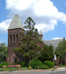
- Chapel of the Immaculate Conception (ID#4121), 400 South Orange Avenue
- Eugene V. Kelly Carriage House (Father Vincent Monella Art Center) (ID#1360), Seton Hall University, South Orange Avenue
- Montrose Park Historic District (ID#3147), roughly bounded by South Orange Avenue, Holland Road, the City of Orange boundary and the NJ Transit railroad right-of-way
- Mountain Station Railroad Station (ID#1361), 449 Vose Avenue
- Old Main Delaware, Lackawanna and Western Railroad Historic District (ID#3525), Morris and Essex Railroad Right-of-Way (NJ Transit Morristown Line), from Hudson, Hoboken City to Warren, Washington Township, and then along Warren Railroad to the Delaware River.
- Prospect Street Historic District (ID#4), bounded by South Orange Avenue on the north, Tichenor Avenue on the east, Roland Avenue on the south and railroad track on the west
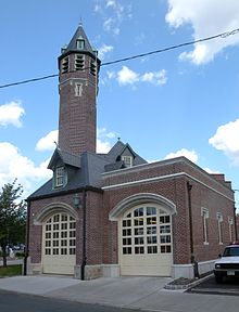
- South Orange Fire Department (ID#41), First and Sloan avenues
- South Orange Railroad Station (ID#1362), 19 Sloan Street
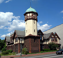
- South Orange Village Hall (ID#1363), corner South Orange Avenue and Scotland Road
- Temple Sharey Tefilo Israel (ID#78), 432 Scotland Road
Local character
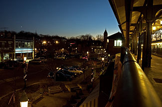
The town is one of only a few in New Jersey to retain gas light street illumination (others include Riverton, Palmyra, Glen Ridge and some parts of Orange). The gaslight has long been the symbol of South Orange (together with the distinctive Village Hall). Many of the major roads in town do have modern mercury vapor streetlights (built into gaslight frames), but most of the residential sections of the town are still gaslit. A proposal to replace all the gaslights in town with electric streetlights was explored as both a cost-saving and security measure during the 1970s. And although the changeover to electric was rejected at the time, the light output of the lamps was subsequently increased to address the concern that the streets of South Orange were too dimly lit. Be that as it may, there have been claims that South Orange has more operating gaslights than any other community in the United States.
Architecture is extremely varied. Most of the town is single-family wood framed houses, but there are a few apartment buildings from various eras as well as townhouse-style condominiums of mostly more recent vintage. Houses cover a range that includes every common style of the Mid-Atlantic United States since the late nineteenth century, and in sizes that range from brick English Cottages to giant Mansard-roofed mansions. Tudor, Victorian, Colonial, Ranch, Modern, and many others are all to be found. Most municipal government structures date from the 1920s, with a few being of more modern construction.
Many residents commute to New York City, but others work locally or in other parts of New Jersey. South Orange has a central business district with restaurants, banks, and other retail and professional services. There are a few small office buildings, but no large-scale enterprise other than Seton Hall University.
Government
South Orange provides the usual facilities for a municipality of this size; fire, police, a library of over 90,000 volumes, a municipal pool, a recreation center, parks, baseball diamonds, tennis courts, trash and yard waste removal provided by contractors, Public, educational, and government access (PEG) cable TV, among others. As noted above, the school board is shared with adjacent Maplewood.
Local government
South Orange is governed under a Special Charter granted by the New Jersey Legislature by a six member board of trustees and a village president (equivalent to a mayor), all unpaid positions. Trustees are elected in nonpartisan elections on an at-large basis to staggered four-year terms of office.[20] Local political parties are formed on an ad-hoc basis, generally focused on key issues of local concern; national political parties do not officially participate in township elections.
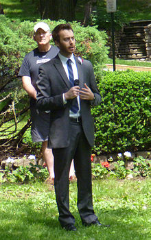
As of 2011[update], the Village President of South Orange is Alex Torpey, whose term of office ends in May 2015.[21] Members of the Board of Trustees are Janine Bauer (2013), Deborah Davis Ford (2015), Michael Goldberg (2013), Nancy Gould (2013), Howard Levison (2015) and Mark Rosner (2015).[22]
In the municipal election held on May 10, 2011, 23-year-old Alex Torpey was elected Village president by a margin of 14 votes, while trustees Deborah Davis Ford, Howard Levison and Mark Rosner were re-elected to four-year terms of office, having run unopposed.[21][23] In the 2009 elections with two incumbents not running for re-election, Michael Goldberg was elected to another four-year term, along with newcomers Janine Bauer and Nancy Gould.[24]
Federal, state and county representation
South Orange is split between the 8th and 10th Congressional districts and is part of New Jersey's 27th state legislative district.[25]
New Jersey's Eighth Congressional District is represented by Bill Pascrell (D, Paterson). New Jersey's Tenth Congressional District is represented by Donald M. Payne (D, Newark). New Jersey is represented in the United States Senate by Frank Lautenberg (D, Cliffside Park) and Bob Menendez (D, Hoboken).
27th Legislative District of the New Jersey Legislature, which is represented in the New Jersey Senate by Richard Codey (D, Roseland) and in the New Jersey General Assembly by Mila Jasey (D, South Orange) and John F. McKeon (D, West Orange).[26] The Governor of New Jersey is Chris Christie (R, Mendham).[27] The Lieutenant Governor of New Jersey is Kim Guadagno (R, Monmouth Beach).[28]
Essex County's County Executive is Joseph N. DiVincenzo, Jr.[29] The executive, along with the Board of Chosen Freeholders administer all county business. The county's Board of Chosen Freeholders consists of nine members, four elected on an at-large basis and one from each of five wards, who serve terms of office on a concurrent basis.[30] As of 2011 Essex County's Freeholders are Freeholder President Blonnie R. Watson (at large)[31], Freeholder Vice President Ralph R. Caputo (District 5)[32], Rufus I. Johnson (at large)[33], Donald M. Payne, Jr. (at large)[34], Patricia Sebold (at large)[35], Samuel Gonzalez (District 1)[36], D. Bilal Beasley (District 2)[37], Carol Y. Clark (District 3)[38] and Linda Lordi Cavanaugh (District 4).[39][40]
Politics
On the national level, South Orange leans strongly toward the Democratic Party. In 2008, Democrat Barack Obama received 81% of the South Orange vote, defeating Republican John McCain.[41]
Education
The township shares a common school system, the South Orange-Maplewood School District, with the adjacent town of Maplewood. The district has a single high school, Columbia High School, located in Maplewood (but nearly on the town border), two middle schools and several elementary schools in each town.
Schools in the district (with 2006-07 school enrollment data from the National Center for Education Statistics[42]) are:
Elementary Schools (K-5)
- Clinton Elementary School (K-5, 461 students) - Maplewood
- Jefferson Elementary School (3-5, 367 students) - Maplewood
- Marshall Elementary School (K-2, 433 students) - South Orange
- Seth Boyden Elementary School (K-5, 430 students) - Maplewood
- South Mountain Elementary School / Annex (K-5, 549 students) - South Orange
- Tuscan Elementary School (K-5, 550 students) - Maplewood
Middle Schools (6-8)
- Maplewood Middle School (696 students) - Maplewood
- South Orange Middle School (675 students) - South Orange
High School (9-12)
- Columbia High School (1,929 students) - Maplewood
- Private schools
Our Lady of Sorrows School is a K-8 elementary school operated by the Roman Catholic Archdiocese of Newark.[43]
Marylawn of the Oranges High School is an all-girl, private, Roman Catholic high school. It is operated by the Roman Catholic Archdiocese of Newark.
- Higher Education
Seton Hall University is located in South Orange. The University was founded in 1856 by the Roman Catholic Archdiocese of Newark and named after Elizabeth Ann Seton, the first American saint. South Orange has a college feel with this Division I university located along the east side of South Orange Avenue, the community's main boulevard. The school serves approximately 9,700 students.
Transportation
South Orange is served by two New Jersey Transit railroad stations along the Morristown Line: the South Orange station, located on South Orange Avenue near the Intersection of Vose Avenue, and the Mountain station, located in the Montrose section of South Orange.
In addition to trains, New Jersey Transit operates three bus lines that run through South Orange. These include the 31 Coach USA Bus which stops at the corner of Irvington Avenue and Academy Street and travels between the Livingston Mall and Newark Penn Station, the 92 route which goes from South Orange Train Station to Branch Brook Park in Newark, and the 107 route which goes from South Orange Train Station to the Port Authority Bus Terminal in New York City.
Local arts
South Orange Performing Arts Center (SOPAC) is located at 1 SOPAC Way, nestled right next to the NJ Transit South Orange station. The performance venue is a 415-seat proscenium theater, with a five-screen Clearview Cinemas movie theater, and a dance studio/rental space in the same complex.
SOPAC presents music, family, dance, theater, and comedy programs throughout the year. Notable artists and companies who have performed at SOPAC include Paquito D'Rivera, the Tommy Dorsey Orchestra, Olympia Dukakis, Richie Havens, Yo-Yo Ma, James Marsters, Eddie Palmieri, Madeleine Peyroux, Paula Poundstone, Anoushka Shankar, Phoebe Snow, Angie Stone, Sweet Honey in the Rock, Dionne Warwick, and Nancy Wilson.
The plans for SOPAC were first spoken of during the mid-1990s, and in the early 2000s the project was set into motion, with Seton Hall University partnering with SOPAC and construction in August 2004. The complex opened on November 3, 2006 to the general public.[44]
SOPAC is still relatively young for an arts organization, but is making big strides in programming, arts education, and reaching out to the community. Partnerships with NJ-based companies like Lydia Johnson Dance and Battery Factory Theater have expanded their arts education initiative. SOPAC also partners with Seton Hall University to present Seton Hall Arts Council events throughout the year. These events include the Classical Concert Series, Jazz 'n the Hall, and Seton Hall Theatre—student theater productions.
Local media
WSOU-FM, "Seton Hall's Pirate Radio", is a non-commercial educational public radio station licensed to South Orange and has studios and offices on the campus of Seton Hall University. The station operates at 89.5 FM.
Community information
- The town has a municipal swimming pool open to all residents. Residents may purchase a Photo I.D. badge for an annual fee of $20, which provides access to the South Orange Community Pool and full access to other community facilities and programs;[45] non-residents may use the pool for a small fee on a per visit basis on a guest pass that must be purchased by a resident. The non-resident also must go to the pool with a resident. In most area towns, municipal pool memberships are restricted or costly, but the pool in South Orange was built on land willed to the town for common use. The original pool, built in the 1920s, was reportedly the first free community pool to be built in the United States. It was replaced by an Olympic-size pool in 1972.
- The town was the first in the nation to have an Affinity credit card scheme, the idea of the municipal affinity credit card being originated by former village president William Calabrese.
- When the town was wired for telephones and electricity in the early 20th century, the poles and wires were not allowed to run along the curb lines of streets as they do in most towns. In some sections they run along property lines in the middle of blocks, and in others they run underground. This is aesthetically pleasing but complicates access to the lines, and it delayed the introduction of cable television. Occasional proposals to replace gas lights with electric lights run across the obstacle that there is no source of electric power along the streets.
- The former telephone company system of identifying exchanges is still evidenced by the 761, 762, and 763 prefixes used for most lines in South Orange and Maplewood, which would have originally been referred to as SO1, SO2, and SO3.
- South Orange and Maplewood share one of the largest online communities in the nation, featuring a very active message board at www.maplewoodonline.com.
- South Orange's full official name is the "Township of South Orange Village." This name was originally adopted in lieu of the Village of South Orange because it allowed South Orange to receive more federal aid that was directed to Townships during the 1970s as many federal authorities were unfamiliar with the New Jersey municipal system, in which a township is not formally different from any other municipal designation. Other municipalities in New Jersey also adopted similar strategies, notably the Township of the Borough of Verona.
- South Orange was the first municipality in New Jersey to recognize civil unions for homosexual couples. Exactly one hour after unions became legal in South Orange, they were recognized in neighboring Maplewood.
- The News-Record weekly newspaper reports on both South Orange and Maplewood, and there are other shared institutions as well.
Notable residents
Main article: List of people from South Orange, New JerseyReferences
- ^ Village Administrator, Township of South Orange Village. Accessed May 29, 2011.
- ^ U.S. Geological Survey Geographic Names Information System: Township of South Orange Village, Geographic Names Information System. Retrieved October 16, 2007.
- ^ 2010 Census: Essex County, Asbury Park Press. Accessed June 14, 2011.
- ^ a b "American FactFinder". United States Census Bureau. http://factfinder.census.gov. Retrieved 2008-01-31.
- ^ A Cure for the Common Codes: New Jersey, Missouri Census Data Center. Retrieved July 14, 2008.
- ^ "US Board on Geographic Names". United States Geological Survey. 2007-10-25. http://geonames.usgs.gov. Retrieved 2008-01-31.
- ^ a b c d Shaw, William H. "History of Essex and Hudson Counties", Philadelphia: Everts and Peck, 1884.
- ^ "The Story of New Jersey's Civil Boundaries: 1606-1968", John P. Snyder, Bureau of Geology and Topography; Trenton, New Jersey; 1969. p. 132.
- ^ New Jersey State Commission on County and Municipal Government, Modern Forms of Municipal Government, 1992, Chapter VI: Municipal Names and Municipal Classification
- ^ "Opponent of Distribution Formula For Federal Aid Steps Up Attack; As South Orange Moves to Become Township, Montclair Aide Calls for Equitable Sharing", The New York Times August 29, 1977. p. 59.
- ^ "US Gazetteer files: 2010, 2000, and 1990". United States Census Bureau. 2011-02-12. http://www.census.gov/geo/www/gazetteer/gazette.html. Retrieved 2011-04-23.
- ^ "Average weather for South Orange, New Jersey". Weather.com. http://www.weather.com/weather/climatology/monthly/07079?x=0&y=0. Retrieved December 20, 2008.
- ^ New Jersey Resident Population by Municipality: 1930 - 1990, Workforce New Jersey Public Information Network. Retrieved December 10, 2009.
- ^ Naoma Welk, South Orange, Charleston SC: Arcadia, 2002
- ^ a b Beatrice P Herman, The Trail to Upland Plantations, Worrall, 1976
- ^ Thomas T Taber III, The Delaware, Lackawanna & Western Railroad / In the Nineteenth Century, Muncy PA: T Taber, 1977
- ^ Edward Hamm, Jr, The Public Service Trolley Lines in New Jersey, Polo IL: Transportation Trails, 1991
- ^ Thomas T Taber III, The Delaware, Lackawanna & Western Railroad / In the Twentieth Century, Muncy PA: T Taber, 1977
- ^ http://southorange.org/parking/waitingLists.asp
- ^ 2005 New Jersey Legislative District Data Book, Rutgers University Edward J. Bloustein School of Planning and Public Policy, April 2005, p. 125.
- ^ a b Village President, Township of South Orange Village. Accessed May 29, 2011.
- ^ Village Government, Township of South Orange Village. Accessed May 29, 2011.
- ^ Staff. "South Orange Voters Elect New Village President", Township of South Orange Village, May 17, 2011. Accessed May 29, 2011.
- ^ Khavkine, Richard. "South Orange voters elect incumbent and running-mates", The Star-Ledger, May 12, 2009. Accessed May 29, 2011. "In South Orange, incumbent Michael Goldberg and running mates Janine Bauer and Nancy Gould, running under the moniker 'Pure Progress', swept aside a trio of challengers, including former trustee Stephen Steglitz."
- ^ 2011 New Jersey Citizen's Guide to Government, New Jersey League of Women Voters, p. 64. Retrieved May 29, 2011.
- ^ "Legislative Roster: 2010-2011 Session". New Jersey Legislature. http://www.njleg.state.nj.us/members/roster.asp. Retrieved 2010-12-06.
- ^ "About the Governor". New Jersey. http://www.nj.gov/governor/about/. Retrieved 2010-01-21.
- ^ "About the Lieutenant Governor". New Jersey. http://www.nj.gov/governor/lt/. Retrieved 2010-01-21.
- ^ Essex County Executive, Essex County, New Jersey. Accessed January 3, 2011.
- ^ Definition of a Freeholder, Essex County, New Jersey. Accessed January 3, 2011.
- ^ Blonnie R. Watson, Essex County, New Jersey. Accessed January 3, 2011.
- ^ Ralph R. Caputo, Essex County, New Jersey. Accessed January 3, 2011.
- ^ Rufus I. Johnson, Essex County, New Jersey. Accessed January 3, 2011.
- ^ Donald M. Payne, Jr., Essex County, New Jersey. Accessed January 3, 2011.
- ^ Patricia Sebold, Essex County, New Jersey. Accessed January 3, 2011.
- ^ Samuel Gonzalez, Essex County, New Jersey. Accessed January 3, 2011.
- ^ D. Bilal Beasley, Essex County, New Jersey. Accessed January 3, 2011.
- ^ Carol Y. Clark, Essex County, New Jersey. Accessed January 3, 2011.
- ^ Linda Lordi Cavanaugh, Essex County, New Jersey. Accessed January 3, 2011.
- ^ The Board of Chosen Freeholders, Essex County, New Jersey. Accessed January 3, 2011.
- ^ http://www.state.nj.us/state/elections/results_2009_doe.html
- ^ Data for the South Orange-Maplewood School District, National Center for Education Statistics. Retrieved February 24, 2009.
- ^ Essex County Catholic Elementary Schools, Roman Catholic Archdiocese of Newark. Retrieved February 24, 2009.
- ^ Falkenstein, Michelle (December 31, 2006). "Around the Scene, a Whirl of Change". The New York Times. http://www.nytimes.com/2006/12/31/nyregion/nyregionspecial2/31njarts.html?scp=278&sq=jersey%20city%20YMCA&st=cse.
- ^ Department of Recreation and Cultural Affairs, South Orange Village Township. Retrieved July 15, 2006.
External links
- The Township of South Orange Village
- Main Street South Orange Inc. (Not-for-profit community-based downtown improvement organization)
- Data for the South Orange-Maplewood School District, National Center for Education Statistics
- Orange Lawn Tennis Club
- South Orange Historical and Preservation Society
- South Orange-Maplewood Community Coalition on Race (Community organization providing information about town for prospective buyers and organizing events for current residents)
- South Orange-Maplewood School District
- South Orange-Maplewood School District's 2009–10 School Report Card from the New Jersey Department of Education
- South Orange Performing Arts Center
- The South Orange Public Library
Municipalities and communities of Essex County, New Jersey Cities Boroughs Townships Belleville | Bloomfield | Cedar Grove | City of Orange | Fairfield | Irvington | Livingston | Maplewood | Millburn | Montclair | Nutley | South Orange | Verona | West Caldwell | West Orange
Communities Broadway | Downtown Newark | Fairmount | Forest Hill | Halcyon Park | Ironbound | Llewellyn Park | Roseville | Seventh Avenue | Short Hills | Springfield/Belmont | University Heights | Upper Montclair | Vailsburg | Weequahic
Categories:- South Orange, New Jersey
- The Oranges, New Jersey
- Former villages in New Jersey
- Populated places established in 1869
- Townships in Essex County, New Jersey
Wikimedia Foundation. 2010.

