- Rahway, New Jersey
Infobox Settlement
official_name = Rahway, New Jersey
settlement_type = City
nickname =
motto =
imagesize =
image_caption =
image_
mapsize = 250x200px
map_caption =
mapsize1 =
map_caption1 =
subdivision_type = Country
subdivision_type1 = State
subdivision_type2 = County
subdivision_name =United States
subdivision_name1 =New Jersey
subdivision_name2 = Union
government_type =Faulkner Act (Mayor-Council)
leader_title =Mayor
leader_name = James J. Kennedy
leader_title1 = Administrator
leader_name1 = Peter H. Pelissier
established_title = Incorporated
established_date =April 19 ,1858
area_magnitude =
area_total_sq_mi = 4.1
area_total_km2 = 6.4
area_land_sq_mi = 3.6
area_land_km2 = 5.6
area_water_sq_mi = 0.5
area_water_km2 = 0.8
area_urban_sq_mi =
area_urban_km2 =
area_metro_sq_mi =
area_metro_km2 =
population_as_of = 2007
population_footnotes =
population_total = 28189
population_metro =
population_urban =
population_density_km2 = 2321
population_density_sq_mi = 6642.7
timezone = EST
utc_offset = -5
timezone_DST = EDT
utc_offset_DST = -4
latd = 40 |latm = 36 |lats = 26 |latNS = N
longd = 74 |longm = 16 |longs = 52 |longEW = W
elevation_m = 6
elevation_ft = 20
elevation_footnotes = [Gnis|885363|City of Rahway,Geographic Names Information System , accessedOctober 8 ,2007 .]
postal_code_type = ZIP code
postal_code = 07065
area_code = 732
website = http://www.cityofrahway.com
blank_name = FIPS code
blank_info = 34-61530GR|2 [ [http://mcdc2.missouri.edu/webrepts/commoncodes/ccc_nj.html A Cure for the Common Codes: New Jersey] , Missouri Census Data Center. AccessedJuly 14 ,2008 .]
blank1_name = GNIS feature ID
blank1_info = 0879585GR|3
footnotes =Rahway (pronEng|ˈrɔweɪ) is a city in southern Union County,
New Jersey ,United States . It is part of theNew York metropolitan area , being fifteen miles southwest of Manhattan and five miles west of Staten Island. As of theUnited States 2000 Census , the city population was 26,500.History
Rahway and the surrounding area were once the home of the
Lenni Lenape Native Americans, and tradition states that the city was named after Rahwack, a local tribal chief."Rahway" from theEncyclopædia Britannica Eleventh Edition of 1911, accessedJanuary 3 ,2007 .] Formal European settlement began in 1664 with the purchase by the English from the Lenape of theElizabethtown Tract , which encompassed lands from the mouth of theRaritan River and included all of present-day Union County as well as parts of Somerset, Middlesex, Morris and Essex counties.Rahway saw limited action during theAmerican Revolutionary War because of its proximity toStaten Island , Elizabethtown and Perth Amboy. In January 1777, rebels were victorious against the British in theBattle of Spanktown , which resulted in the death of some 100 British troops. The battle was named this after Rahway's original name given to it by the first settlers, Spanktown.The
Merchants and Drovers Tavern resides at the corner of St. Georges and Westfield Avenues. The earliest buildings at the site date to 1795 and the property remains one of Rahway's most prominent historical landmarks. [ [http://www.merchantsanddrovers.org/Historical%20Background.htm The Merchants and Drovers Tavern: Historical background] , accessedJune 7 ,2006 .]George Washington visited Rahway during his travel toNew York City prior to his presidential inauguration in 1789. A marker across the street from the tavern reads::"Here, on
April 23 ,1789 , on his way to New York City, Washington":"was received by troops from Elizabethtown and Newark. He was":"entertained at the inn kept by Samuel Smith by gentlemen of the town."Following the Revolution, Rahway became the home of the first national mint to create a coin bearing the inscription "
E pluribus unum ". AUnited States Post Office established in Rahway was one of only six in the entire state in 1791.Rahway grew due to its location along the major stagecoach and later, railroad lines between
New York City andPhiladelphia, Pennsylvania . The navigableRahway River , which flows through the city, also aided the city's commercial growth.As immigrants from Britain,
Ireland andGermany streamed into what was then Rahway Township in the 1850s, Rahway became incorporated as a city by an act of the State Legislature onApril 19 ,1858 from portions of Rahway Township in Union and Woodbridge Township, in Middlesex County. In 1860, the portion of Rahway that had been part of Middlesex County was transferred to Union. OnMarch 13 ,1861 , the remainder of Rahway Township became part of Rahway City."The Story of New Jersey's Civil Boundaries: 1606-1968", John P. Snyder, Bureau of Geology and Topography; Trenton, New Jersey; 1969. p. 194.]The first municipal elections for the Mayor and Council were conducted on
April 19 ,1858 , and the Council held its first meeting onMay 3 ,1858 .The city became home to dozens of major manufacturers, including the Regina Music Box Company, Wheatena, Mershon Bros. and, most importantly,
Merck & Co. , which was established in Rahway in 1903, when George Merck moved his small chemical company to Rahway from New York City. The company remained in Rahway through the presidency ofGeorge W. Merck and after.The national decline in industry after
World War II led to the closure of most of Rahway's major manufacturing facilities except for Merck and a general deterioration of the city's central business district.Geography
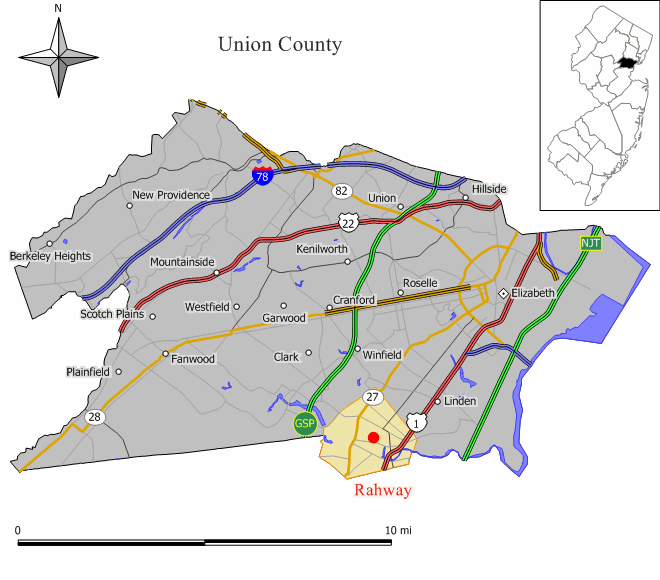
Rahway is located at coor dms|40|36|26|N|74|16|52|W|city (40.607103, -74.280998)GR|1.
According to the
United States Census Bureau , the city has a total area of 4.0square mile s (10.5km² ), of which, 4.0 square miles (10.3 km²) of it is land and 0.1 square miles (0.1 km²) of it (1.24%) is water.Rahway is bordered to the Northwest by Clark, to the Northeast by Linden and to the South by Woodbridge in Middlesex County.
The city is home to about ten parks. The best-known park is
Rahway River Park , which is maintained by Union County, and is also partially located in Clark. The park hosts a number of baseball fields, picnic areas, a lake and a public pool.The
Rahway River travels through Rahway, entering from Clark at Rahway River Park. The river receives the waters of Robinsons Branch at Elizabeth Avenue between West Grand Avenue and West Main Street, and then receives the waters of the South Branch at East Hazlewood Avenue and Leesville Ave. Finally the river leaves Rahway to enter the city limits of Linden and Carteret before flowing into theArthur Kill .Demographics
USCensusPop
1930=16011
1940=17498
1950=21290
1960=27699
1970=29114
1980=26723
1990=25325
2000=26500
estimate= 28189
estyear=2007
estref= [http://factfinder.census.gov/servlet/SAFFPopulation?_event=Search&geo_id=06000US3402748090&_geoContext=01000US%7C04000US34%7C05000US34027%7C06000US3402748090&_street=&_county=rahway&_cityTown=rahway&_state=04000US34&_zip=&_lang=en&_sse=on&ActiveGeoDiv=geoSelect&_useEV=&pctxt=fph&pgsl=060&_submenuId=population_0&ds_name=null&_ci_nbr=null&qr_name=null®=null%3Anull&_keyword=&_industry= Census data for Rahway city] ,United States Census Bureau . AccessedAugust 10 ,2007 .]
footnote=Population 1930 - 1990. [ [http://www.wnjpin.net/OneStopCareerCenter/LaborMarketInformation/lmi01/poptrd6.htm Jersey Resident Population by Municipality: 1930 - 1990] , Workforce New Jersey Public Information Network. AccessedMarch 1 ,2007 .] As of thecensus GR|2 of 2000, there were 26,500 people, 10,028 households, and 6,728 families residing in the city. Thepopulation density was 6,642.7 people per square mile (2,564.3/km²). There were 10,381 housing units at an average density of 2,602.2/sq mi (1,004.5/km²). The racial makeup of the city was 60.19% White, 27.07% African American, 0.16% Native American, 3.58% Asian, 0.05% Pacific Islander, 5.62% from other races, and 3.33% from two or more races. Hispanic or Latino of any race were 13.87% of the population.There were 10,028 households out of which 30.0% had children under the age of 18 living with them, 46.7% were married couples living together, 15.6% had a female householder with no husband present, and 32.9% were non-families. 28.0% of all households were made up of individuals and 11.7% had someone living alone who was 65 years of age or older. The average household size was 2.63 and the average family size was 3.24.
In the city the population was spread out with 23.9% under the age of 18, 7.8% from 18 to 24, 32.0% from 25 to 44, 21.8% from 45 to 64, and 14.5% who were 65 years of age or older. The median age was 37 years. For every 100 females there were 91.2 males. For every 100 females age 18 and over, there were 86.5 males.
The median income for a household in the city was $50,729, and the median income for a family was $61,931. Males had a median income of $41,047 versus $32,091 for females. The
per capita income for the city was $22,481. About 5.4% of families and 7.1% of the population were below thepoverty line , including 9.3% of those under age 18 and 8.2% of those age 65 or over.Government
Local government
The City of Rahway is governed under a Mayor-Council system of municipal government under the Faulkner Act. ["2005 New Jersey Legislative District Data Book",
Rutgers University Edward J. Bloustein School of Planning and Public Policy , April 2005, p. 98.]Under the City of Rahway's form of government, all executive and administrative authority is vested in the office of the Mayor who appoints the Business Administrator and department directors. The
Mayor of Rahway is James J. Kennedy (Democrat), who was first elected in 1990 and is serving his fifth term in office. [ [http://www.cityofrahway.com/mayor_bio.htm The Honorable James J. Kennedy] , city of Rahway. AccessedApril 14 ,2008 .]The Business Administrator is responsible for development of the Mayor’s annual budget, the administration of the city’s personnel system and the supervision of the management of the city’s departments. This form of government gives citizens a centralized line of authority for the efficient management of the city’s business. [http://www.cityofrahway.com/mayor.htm Mayor and Administration] , City of Rahway. Accessed
April 14 ,2008 .]The Municipal Council is made up of nine members elected by the citizens of Rahway. There are six wards in the City of Rahway and a Councilmember is elected for a four-year term by the citizens from each respective ward. There are three Councilmembers-at-large who represent the entire City and run with the Mayor for four-year terms. [ [http://www.cityofrahway.com/municipal_council.htm Municipal Council] , City of Rahway. Accessed
September 8 ,2006 .]Members of the Municipal Council are [ [http://www.cityofrahway.com/municipal_council_list.htm Municipal Council Members] , City of Rahway. Accessed
January 3 ,2007 .] :
*First Ward - Robert Rachlin
*Second Ward - Francis Janusz
*Third Ward - Jerry Scaturo
*Fourth Ward - David Brown, Council Vice President
*Fifth Ward - Jennifer Wenson Maier
*Sixth Ward - Samson Steinman, Council President
*At Large - James Baker
*At Large - Salvatore Mione
*At Large - Nancy SaligaFederal, state and county representation
Rahway is in the Tenth Congressional District and is part of New Jersey's 22nd Legislative District. [ [http://www.lwvnj.org/pubs/CG06.pdf 2006 New Jersey Citizen's Guide to Government] , New Jersey
League of Women Voters , p. 63. AccessedAugust 30 ,2006 .]Education
The
Rahway Public Schools serve students in kindergarten through twelfth grade. Schools in the district (with 2005-06 enrollment data from theNational Center for Education Statistics [ [http://nces.ed.gov/ccd/schoolsearch/school_list.asp?Search=1&DistrictID=3413530 Data for the Rahway Public Schools] ,National Center for Education Statistics . AccessedApril 14 ,2008 .] ) are four K-5 elementary schools, one 6-8 Middle School and one 9-12 High School.* Grover Cleveland School (340)
* Franklin School (534)
* Madison School (300)
* Roosevelt School (684)
* Rahway Middle School (937)
*Rahway High School (1,139)Transportation
Highways
Rahway is served by
U.S. Route 1/9 , and Route 27. The city is sandwiched in between theGarden State Parkway and theNew Jersey Turnpike , which are each located about two miles outside of the city limits.Public Transportation
Local public transportation is provided by
New Jersey Transit with bus service to Elizabeth, Perth Amboy and Newark via the 62 bus.New Jersey Transit bus 115 provides local service and interstate service to thePort Authority Bus Terminal inMidtown Manhattan .Rahway Train Station serves
New Jersey Transit 'sNorth Jersey Coast Line andNortheast Corridor Line . The City of Rahway and New Jersey Transit helped fund a US$16 million renovation for the station in 1999 and a public plaza in front of the station was completed in 2001. The station has spurred cleanup and revitalization downtown. A new US$11.2 million 524-space parking deck opened across the street from the station in January 2005, helping train commuters and allowing the city to transform old parking lot space into new buildings and residences.Airport
Newark Liberty International Airport is approximately 20 minutes away.Downtown revitalization
Beginning in the early 1990s and continuing through the present day, the City of Rahway has rebounded as its downtown began to see the construction of new restaurants, art galleries, market-rate housing and the old Rahway Theatre reopening as the [http://www.ucac.org Union County Arts Center] .
In September 1999, remnants of
Hurricane Floyd swept across New Jersey and caused severe damage. The Rahway Public Library was on a flood plain and suffered over US$1 million in flood damage. The building was demolished in October 2001. A new library along a less flood-prone area of the Rahway River was constructed and opened onMarch 22 ,2004 , behind the city's municipal building.Rahway State Prison
East Jersey State Prison , formerly (and popularly) known as Rahway State Prison, is actually located in Woodbridge Township at the border with Rahway. The prison's mailing address is in Rahway, leading many to believe the facility resides there. The prison's official name was changed to East Jersey State Prison as ofNovember 30 ,1988 , at the request of the citizens of Rahway. [ [http://www.injersey.com/day/story/0,2379,355117,00.html What's in a name? Plenty if we're talking prison] ,Home News Tribune ,February 15 ,2001 .]Noted residents
*
Abraham Clark (1725-1794), Signer of the Declaration of Independence, is buried at the Rahway Cemetery.
*Paul Dembling , the Federal attorney responsible for forming NASA as a government agency in July 1958, was born and raised in Rahway.
*Milton Friedman (1912-2006), Economist, was born in New York City but raised in Rahway. [ [http://www.chicagotribune.com/business/la-111606friedman,1,5214109.story?coll=chi-news-hed Nobel winner Milton Friedman dies at 94] , "Chicago Tribune ",November 16 ,2006 .]
*Antonio Garay (1979-), Defensive Tackle for theChicago Bears . [ [http://www.chicagobears.com/team/player26.html Antonio Garay] ,Chicago Bears . AccessedMay 17 ,2007 . "Earned Prep Star All-American and All-New Jersey Group III honors as a senior at Rahway H.S. in Rahway, N.J. after totaling 141 tackles and 10 sacks in his final season... Outstanding wrestler who was tabbed the 275-pound national champion by the National High School Coaches' Association"]
*Wayne Gilchrest (1946-), U.S. Congressman, was born in Rahway. [ [http://gilchrest.house.gov/bio.asp About Wayne] , Congressman Wayne Gilchrest. AccessedMay 17 ,2007 . "Born in Rahway, New Jersey, he was the fourth of Elizabeth and Arthur Gilchrest's six boys."]
*Dory Previn (1929-), Lyricist and singer-songwriter, born here (as Dorothy Veronica Langan).
*Carl Sagan (1934-1996), Astronomer, lived in Rahway and was a Rahway High School graduate. [ [http://libserv.aip.org:81/ipac20/ipac.jsp?uri=full=3100001~!5076~!0&profile=newcustom-icos Oral history interview with Carl Sagan, 1991 August 27.] , accessedNovember 28 ,2006 .] Sagan has his own display case in the library on the second floor.
*Chris Smith (1953-), U.S. Congressman, was born in Rahway. [ [http://bioguide.congress.gov/scripts/biodisplay.pl?index=s000522 Chris Smith profile] ,United States Congress . AccessedJune 5 ,2007 .]
*Emanuel Yarbrough (1964-) Raised in Rahway, Manny was the 1995 USA World Sumo Champion
*Nikola Tesla (1856-1943), formed his company,Tesla Electric Light Company , in Rahway. [Cheney, Margaret. [http://books.google.com/books?id=ti2Jt7XarzMC&pg=PA59&ots=9J4lERrVvx&dq=rahway+tesla&sig=Z3GDBPJLF_DQCnZaON5s2sScKco "Tesla: Man Out of Time"] . AccessedJune 5 ,2007 . "The Tesla Electric Light Company was formed, with headquarters at Rahway, New Jersey, and a branch office in New York.]
*Dr.P. Roy Vagelos (1929-), RetiredMerck & Co. CEO, was a graduate of Rahway High School and lived in Rahway for many years. [Johnson, Robert. [http://www.nytimes.com/2004/11/28/business/yourmoney/28refresh.html "Looking Back Is Not an Option"] , "The New York Times ",November 28 ,2004 . AccessedOctober 19 ,2007 . "He is also promoting his new book "Medicine, Science and Merck" (Cambridge University Press), written with Louis Galambos, describing his path from son of a luncheonette owner in Rahway, N.J., to leader of a pharmaceutical giant."]
*Carolyn Wells (1862-1942), Author and poet who was born in Rahway and is currently interred in Rahway Cemetery. ["CAROLYN WELLS, NOVELIST, DEAD; Noted for Myitery Stories and Nonsense Verse, Also for Children's Works BEGAN WRITING IN RAHWAY Wrote 170 Books by 1937 and 70 Were Mysteries -- Widow of Publisher's Son", "The New York Times ",March 27 ,1942 .]References
External links
* [http://www.cityofrahway.com Official municipal web site]
* [http://www.rahway.net Rahway Public Schools]
*NJReportCard|39|4290|0|Rahway Public Schools
* [http://nces.ed.gov/ccd/schoolsearch/school_list.asp?Search=1&DistrictID=3413530 Data for the Rahway Public Schools] ,National Center for Education Statistics
* [http://www.rcpnj.org Rahway Center Partnership]
* [http://www.ucac.org Union County Arts Center]
* [http://pc.smellycat.com/docs/passenger/rahway.html History of the Rahway Train Station]
* [http://quickfacts.census.gov/ U.S. Census Bureau]
* [http://www.city-data.com/city/Rahway-New-Jersey.html City-Data]
Wikimedia Foundation. 2010.