- New Jersey Route 59
-
"New Jersey Route 22" redirects here. For the current highway called Route 22, see U.S. Route 22 in New Jersey.
Route 59
Lincoln Avenue 
Route information Maintained by New Jersey Department of Transportation Length: 0.15 mi[1] (0.24 km) Existed: 1953 – present Major junctions South end:  CR 610 in Cranford
North end:  Route 28 in Garwood
Highway system New Jersey State Highway Routes
Interstate and US←  Route 58
Route 60  →
→←  US 22
US 22
Route 23  →
→Route 59, at 0.15-mile (0.24 km) long, is the shortest state highway in New Jersey, United States. The route consists entirely of a short block of Lincoln Avenue from New Jersey Route 28 (known locally as North Avenue) in Cranford to Union County Route 610 (known locally as South Avenue). The route crosses under the Raritan Valley Line of New Jersey Transit about halfway down the block, which runs along the community border. Route 59 was originally a proposed alignment of Route 22, which was supposed to head from an intersection with current day New Jersey Route 159 in Morris County at the Pine Brook Bridge before heading through several counties, terminating at an intersection with New Jersey Route 27 in Rahway. Most of the route was not constructed, and a portion in Garwood and Cranford was re-designated Route 59 in the 1953 New Jersey state highway renumbering on January 1, 1953.
Contents
Route description
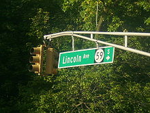 The only sign on NJ 59 depicting the route number is this blade sign at NJ 28 in Cranford
Route 59 begins at a four-way intersection with Union County Route 610 (South Avenue) in the community of the Garwood. Route 59 heads northwestward, passing a couple of local businesses in both directions. The route crosses under the New Jersey Transit-owned Raritan Valley Line and into the community of Cranford. The route continues to the northwest, passing several local businesses before ending at a T-intersection with New Jersey Route 28 (North Avenue). The right-of-way ends at this intersection heading northbound.[2]
History
 Route 22 (1927–1953)
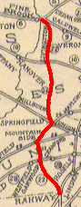
The alignment of Route 59 was designated as part of the proposed State Highway Route 22 in the 1927 renumbering, which was proposed to run from the Pine Brook Bridge over the Passaic River at State Highway Route 6 in Fairfield Township.[3] (This intersection is currently where New Jersey Route 159 currently crosses the bridge.) The route was to continue through parts of Morris, Essex and Union counties, including intersections with State Highway Route 10 at Livingston, U.S. Route 22 (also State Highway Route 29) at Mountainside, State Highway Route 28 at Garwood (where Routes 28 and 59 currently meet), and terminate in the community of Rahway at State Highway Route 27.[4][5] Most of this route was not constructed, except a portion from State Highway Route 28 (North Avenue) in Cranford to South Avenue in Garwood. This portion was renumbered as Route 59 in the 1953 New Jersey state highway renumbering on January 1, 1953 so as not to duplicate U.S. Route 22.[6]
Major intersections
The entire route is in Union County.
Location Mile[1] Destinations Notes Cranford 0.00 CR 610 (South Avenue)Garwood 0.15 Route 28 (North Avenue)1.000 mi = 1.609 km; 1.000 km = 0.621 mi See also
 U.S. Roads portal
 New Jersey portal
- List of state highways in the United States shorter than one mile
References
- ^ a b "Route 59 Straight Line Diagram". New Jersey Department of Transportation. 2009. pp. 1. http://www.state.nj.us/transportation/refdata/sldiag/00000059__-.pdf. Retrieved August 24, 2009.
- ^ Microsoft Inc. (2009). Bing Maps – Overview map of Route 59 (Map). http://www.bing.com/maps/?FORM=Z9LH11#JnJ0cD1wb3MucXM4NXp4OHQ2aDc5XzI0OStOb3J0aCtBdmUrVyUyYytDcmFuZm9yZCUyYytOSiswNzAxNi0yMTI2X19fZV8lN2Vwb3MucXM4MXNkOHQ2a3NrXzEwMitTb3V0aCtBdmUrVyUyYytDcmFuZm9yZCUyYytOSiswNzAxNi0yNjUyX19fZV8mcnRvcD0wJTdlMA==. Retrieved August 24, 2009.
- ^ State of New Jersey, Laws of 1927, Chapter 319.
- ^ ROUTE NO. 22. PINE BROOK BRIDGE TO RAHWAY, by way of West Caldwell, Livingston, Millburn, Springfield, in the vicinity of Garwood and to Route No. 27 in Rahway.. New Jersey General Assembly. 1927. pp. chapter 319
- ^ New Jersey State Highway Department (1927). Map of State Highway Route 22 (Map). http://www.alpsroads.net/roads/nj/log/1927_22.png. Retrieved August 24, 2009.
- ^ 1953 renumbering. New Jersey Department of Highways. http://en.wikisource.org/wiki/1953_New_Jersey_state_highway_renumbering. Retrieved July 31, 2009
External links
Unbuilt Highways in New Jersey Interstate Highways I-695 • I-895State highways Toll roads and other highways Categories:- State highways in New Jersey
- Transportation in Union County, New Jersey


Wikimedia Foundation. 2010.