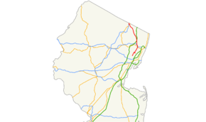
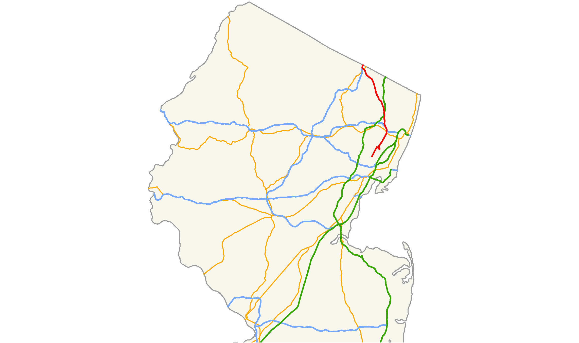
- New Jersey Route 17
-
Route 17
Route information Maintained by NJDOT Length: 27.20 mi[1] (43.77 km) Existed: 1942 (1927 as NJ 2) – present Major junctions South end: 
 Route 7 / CR 507 in North Arlington
 Route 3 in Rutherford
 I-80 in Hackensack
 Route 4 in Paramus
 G.S. Pkwy. in Paramus
CR 507 in Ramsey
 I-287 in Mahwah
North end:  I-287 / NY 17 at New York border in Mahwah
Highway system New Jersey State Highway Routes
Interstate and US←  Route 15
Route 18  →
→←  Route 1
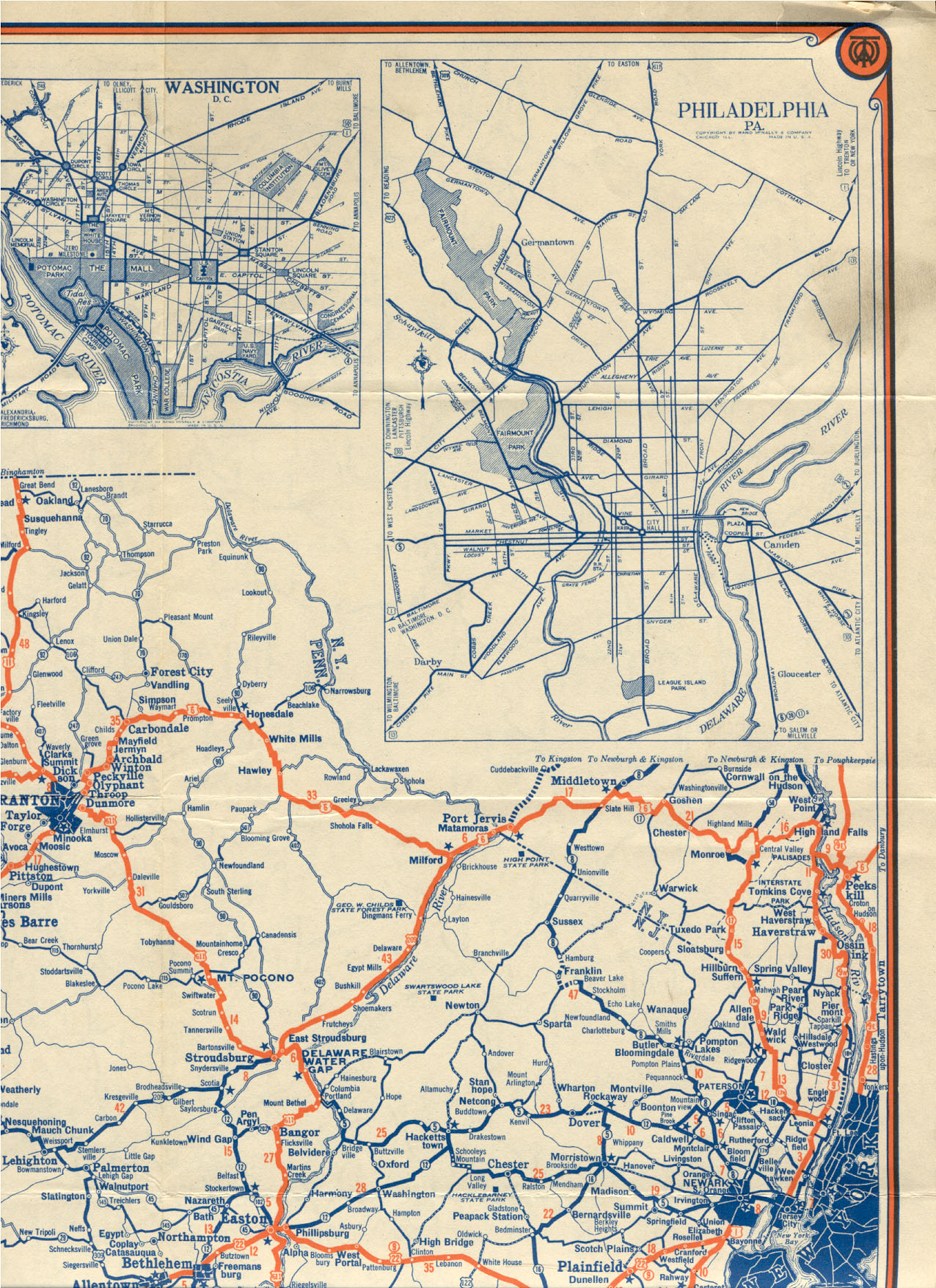
Route 3 →Route 17 is a state highway in Bergen County, New Jersey, United States, that provides a major route from the George Washington Bridge, Lincoln Tunnel and other northeast New Jersey points to the New York State Thruway at Suffern, New York. It runs 27.20 mi (43.77 km) from Route 7/County Route 507 in North Arlington north to the New York border along Interstate 287 in Mahwah, where New York State Route 17 continues into New York. Between Route 7 and Route 3 in Rutherford, Route 17 serves as a local road. From Route 3 north to the junction with U.S. Route 46 in Hasbrouck Heights, the road is a suburban arterial with jughandles. The portion of Route 17, from US 46 to Interstate 287 near the state line in Mahwah, is a limited-access road with all cross traffic handled by interchanges, and many driveways and side streets accessed from right-in/right-out ramps from the right lane. For three miles (5 km) north of Route 4, well over a hundred retail stores and several large shopping malls line the route in the borough of Paramus. The remainder of this portion of Route 17 features lighter suburban development. The northernmost portion of Route 17 in Mahwah runs concurrent with Interstate 287 to the New York border.
Prior to 1927, the route was designated as Route 17N, which was to run from Newark to the New York state line. This route had followed various local streets, including the Franklin Turnpike north of Hackensack. In 1927, Route 17N became Route 2, which was designated along the portion of Route 17N between Route 7 in North Arlington to the New York border near Suffern, New York. This route was moved to a multilane divided highway alignment north of Rutherford by 1937. Route 2 became Route 17 in 1942 to match the designation of New York State Route 17 for defense purposes during World War II. The entire Route 17 corridor was once planned to be a freeway until the 1960s and later plans to extend the route south of Route 3 to Interstate 280 in 1972 and to the New Jersey Turnpike in 1987 both failed. Over the years, the portion of Route 17 north of Route 3 has seen many improvements, including the widening of much of the road to six lanes and the removal of most at-grade intersections in the 1950s as well as more recent improvements to the interchanges with Route 4 in Paramus in 1999 and Essex Street on the Lodi/Maywood border in 2008. The route is currently undergoing improvements between Route 3 and U.S. Route 46 and is expected to see improvements from Williams Avenue in Hasbrouck Heights to south of Route 4 in Paramus.
Contents
Route description
 First northbound Route 17 reassurance shield in North Arlington.
Route 17 begins at an intersection with Route 7 and County Route 507 (Belleville Turnpike) on the border of Kearny, Hudson County and North Arlington, Bergen County. It heads north through North Arlington on Ridge Road, a two-lane local street with speed limits of 25 to 35 mph (40 to 56 km/h)[2] that passes by businesses and the Holy Cross Cemetery on the east side of the road. It intersects County Route 26 (Jauncey Avenue) and crosses into Lyndhurst at the Lincoln Avenue intersection.[1][3] In Lyndhurst, Route 17 intersects County Route 28 (Kingsland Avenue). At the intersection of County Route 30 (Rutherford Avenue), which runs along the border of Lyndhurst and Rutherford, the route turns east onto 40 mph (64 km/h) Rutherford Avenue to parallel the Route 3 freeway to the south and head for the edge of the New Jersey Meadowlands, widening to a four-lane road at the intersection with Orient Way.[2] Route 17 makes a curve to the south, crossing entirely into Lyndhurst, and makes a hairpin turn to the north, widening to a divided highway. The road then crosses into Rutherford and comes to the Route 3 interchange.[1]

Past the Route 3 interchange, Route 17 continues north as a six-lane divided highway with a 50 mph (80 km/h) speed limit and intersections featuring jughandles.[1][2] It passes through residential and commercial areas of Rutherford, intersecting County Route 32 (Meadow Road) before crossing into East Rutherford, where it intersects County Route S32 (Union Avenue) before interchanging with State Route 120 and County Route 120 (Paterson Plank Road).[1] The route runs through Carlstadt, where it crosses into Wood-Ridge. Route 17 comes to an interchange with County Route 36 (Moonachie Road) before entering Hasbrouck Heights.[1] With the exception of a short stretch in Rutherford with a median strip, this section of Route 17 is divided by a Jersey barrier.[3]
In Hasbrouck Heights, the lanes split with the Bendix Diner located between the traffic lanes at the intersection of County Route 40 (Williams Avenue), the last traffic light on Route 17 before the New York state line.[1][3] At the interchange with U.S. Route 46, which only features access to the eastbound direction of U.S. Route 46, Route 17 drops to two lanes in each direction and continues north with the lanes merging back together as the road interchanges with County Route 55 (Terrace Avenue) at an interchange. The road enters Hackensack with the lanes splitting again for the long interchange with Interstate 80. Along this strip, the road is again three lanes in each direction and includes an interchange with County Route 57 (Summit Avenue), crossing into Lodi.[1] The lanes rejoin upon splitting from Interstate 80 with a lane dropping in each direction at the County Route 56 (Essex Street) interchange on the Maywood border. Route 17 continues north as a congested road through commercial areas,[4] crossing into Rochelle Park where the route interchanges with County Route 62 (Passaic Street) at mile marker 11.46 before entering Paramus.[1][3]
At the County Route 61 (Farview Avenue) interchange, the road regains a third lane in each direction. Route 17 passes by Westfield Garden State Plaza on the west side of the road before coming to an interchange with Route 4. Route 17 is flanked by businesses and shopping malls for most of its length in Paramus, passing through what is known as one of the largest concentrations of retail shopping districts in the state, interchanging with Century Road.[1][3][5] Route 17 comes to a partial interchange with the Garden State Parkway (exit 163), with access limited to northbound-to-northbound and southbound-to-southbound movements between the two roads. North of the Garden State Parkway, Route 17 features interchanges for Midland Avenue, the Paramus Park shopping mall and an industrial park, and County Route 80 (Ridgewood Avenue) just north of the Fashion Center shopping mall.[1][3]
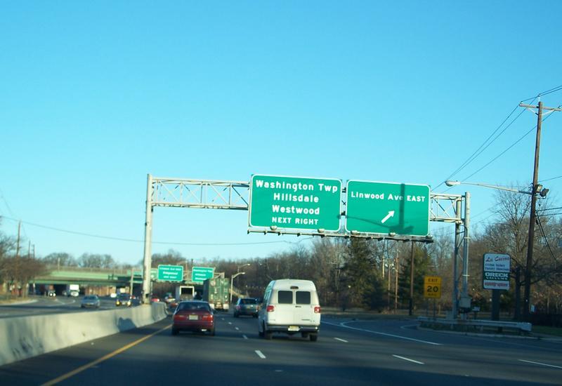
 Route 17 at the Linwood Avenue East exit
Route 17 crosses into Ridgewood and interchanges with County Route 110 (Linwood Avenue), where the penetration of businesses along the side of the road lessens dramatically.[1][3] North of this point, the speed limit is 55 mph (89 km/h).[2] In Ridgewood, the road interchanges with County Route 62 (Paramus Road), crosses the Saddle River, and intersects a separate segment of County Route 62 (Franklin Turnpike) and West Saddle River Road. This intersection, along with other at-grade intersections along this portion of Route 17, is a right-in/right-out (RIRO) intersection with cross traffic blocked by a Jersey barrier. There is another RIRO intersection for County Route 112 (Race Track Road) on the Ho-Ho-Kus border.[1] Upon crossing into Ho-Ho-Kus, the businesses stop along Route 17 and it comes to an interchange with County Route 502 (Hollywood Avenue).[1][3] The route enters Waldwick and interchanges with County Route 77 (Sheridan Avenue). It enters Saddle River, continuing north to an interchange with County Route 90 (Allendale Avenue).[1]
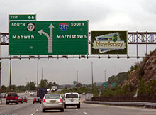
Route 17 enters Allendale, with businesses resuming along the road.[1][3] It enters Upper Saddle River before running through Ramsey, where the road crosses back into Upper Saddle River. The route comes to an interchange with County Route 81 (Lake Street/Crescent Avenue), where it crosses back into Ramsey.[1] In Ramsey, Route 17 turns to the northwest and features a RIRO for County Route 83 (Airmount Avenue), an interchange with County Route 507 (Franklin Turnpike), and an interchange for Island Avenue/Spring Street. The route passes New Jersey Transit’s Ramsey Route 17 train station and enters Mahwah.[1][3] In Mahwah, Route 17 interchanges with County Route 85 (Island Road) and County Route 100 (Ramapo Avenue). North of Ramapo Avenue, Route 17 features an interchange with U.S. Route 202 and crosses the Ramapo River. Route 17 interchanges with Stag Hill Road just before merging with six-lane Interstate 287, which it follows to the New York border, where the road continues into Hillburn, Rockland County as Interstate 287 and New York State Route 17, intersecting Interstate 87 (the New York State Thruway) shortly after the state line.[1][3]
History
Route 17N was defined in 1923 to run "from Newark, by way of Kearny, Rutherford, Hackensack, Ridgewood and Ramsey to the New York State Line".[6] However, only the road north of Route 10 (Essex Street) in Hackensack was shown on the 1925 New Jersey State Highway Department Official State Map, running north along existing roads - First Street and the Franklin Turnpike (now partly called Passaic Street and Paramus Road) - to the state line.[6] The 1927 Tydol Trails Map shows the route running south to Newark, continuing south across Essex Street on Polifly Road, Terrace Avenue and Hackensack Street to East Rutherford, where it followed Meadow Road, Rutherford Avenue, Ridge Road, Kearny Avenue, 4th Street, and the Newark Turnpike to Newark.[7]
 Route 2 (1927-1942)
In the 1927 New Jersey state highway renumbering, Route 17N received the Route 2 designation, and was defined to run from Route 7 in North Arlington to the New York border near Suffern, New York.[8][9] By 1937, the whole old road north of Rutherford was bypassed by a new four-lane divided highway with the exception of the 1927 bridge over the Saddle River in Ridgewood, north of the Paramus Road interchange.[10] This old alignment joins at Paramus Road and leaves just north of the bridge at Franklin Turnpike, which only has access to the southbound lanes through a RIRO intersection.[3] A short-lived spur of Route 2, Route 2N, was defined in 1938 to run from Route 2 (Ridge Road) in Lyndhurst west along Kingsland Avenue and over the Passaic River on the Park Avenue Bridge into Nutley, where it would end at Union Avenue (west of Route 7).[11] In the meantime, New York had numbered its state routes, and the extension of Route 2 north and west to Westfield, New York was numbered as New York State Route 17. New Jersey had not assigned a Route 17 in the 1927 renumbering, and so in March 1942, Route 2 was numbered Route 17 to match and provide a single number for military caravans during World War II.[12][13]
Since at least 1936, Route 17 (then Route 2) was planned for upgrading to a freeway, not only north of U.S. Route 46, but also south to the Newark area.[13] The first plan for a freeway along the length of the route was halted due to World War II, and the second plan for a freeway in the 1960s was cancelled due to the disruption it was projected to cause to businesses and residents along its path. In 1972, there were plans to extend Route 17 past Route 3 to Interstate 280 in Harrison. The plans for this five-mile (eight kilometer), $50 million extension were cancelled due to the defeat of a transportation bond that would have funded the proposed freeway. The interchange at Route 3 was built to allow for this southern extension. Another extension of Route 17 to the New Jersey Turnpike was brought up in 1987, but was ultimately scrapped.[13]
The road north of Route 3 was gradually rebuilt to higher standards between 1953 and 1960; most of this portion of Route 17 was upgraded to six lanes and most at-grade intersections were removed north of Interstate 80 in Lodi [13] The northern 0.39 mi (0.63 km) of Route 17 in Mahwah was incorporated into Interstate 287 in 1994. The Route 4 interchange in Paramus was rebuilt at a cost of $120 million in 1999, replacing the 1932 cloverleaf interchange by adding several flyover ramps.[13] In 2008, construction was completed at the interchange with Essex Street on the Lodi/Maywood border, which involved replacing the Essex Street bridge over Route 17 and improving the interchange ramps, at a cost of $68 million.[14] On January 14, 2008, Governor Jon Corzine announced plans to reduce congestion and improve safety along the portion of Route 17 between Williams Avenue in Hasbrouck Heights to south of Route 4 in Paramus by making it a consistent six lanes.[4] Also, a $14.7 million effort, begun in September 2008, is currently being undertaken to improve safety and reduce bottlenecks along the section of Route 17 between Route 3 and U.S. Route 46.[15]
Major intersections
The entire route is in Bergen County.
Location Mile[1] Destinations Notes North Arlington 0.00 Route 7 / CR 507 (Belleville Turnpike) – Jersey City, BellevilleSouthern terminus Rutherford 4.00 Route 3 – New York CityInterchange East Rutherford 5.76  Route 120 south (Paterson Plank Road) – Meadowlands Sports Complex
Interchange Wood-Ridge 6.70  CR 36 (Moonachie Road) – Meadowlands Sports Complex
Interchange Hasbrouck Heights 8.44  US 46 east – Palisades Park, George Washington Bridge
Interchange; access to eastbound US 46, access from westbound US 46 8.76  CR 55 (Terrace Avenue/Polifly Road) to I-80 east – Hackensack
Interchange Hackensack 9.13 I-80 east – New York CityI-80 exit 64A, southbound exit and northbound entrance 9.33  CR 57 (Summit Avenue) – Hackensack, Hasbrouck Heights
Interchange, northbound closed because of construction Lodi 9.91 I-80 west to G.S. Pkwy.I-80 exit 64A, northbound exit and southbound entrance Maywood 10.19  CR 56 (Essex Street) – Maywood, Paterson
Interchange Rochelle Park 11.46  CR 62 (Passaic Street) – Rochelle Park, Maywood
Northbound exit and southbound entrance Paramus 11.82  CR 61 (Fairview Avenue) – Rochelle Park, Paramus
Interchange 12.30 Garden State Plaza Southbound exit and entrance 12.33 Route 4 to G.S. Pkwy. south – Paterson, Fort Lee, New York CityInterchange 12.34 Ikea Drive/James F. Brown Jr. Drive Southbound exit and entrance 12.88 Century Road – Fair Lawn, River Edge Interchange 13.59 G.S. Pkwy.Interchange; northbound to northbound, southbound to southbound movements only, GSP exit 163 14.33 Midland Avenue – Glen Rock, River Edge Interchange 15.00 Sears Drive Northbound exit and entrance; access to Paramus Park 15.07 A&S Drive Interchange; access to Paramus Park 15.80  CR 80 (Ridgewood Avenue) – Ridgewood, Oradell
Interchange Ridgewood 16.56  CR 110 (Linwood Avenue) – Ridgewood, Washington Township, Hillsdale, Westwood
Interchange 16.88 CR 62 (Paramus Road/East Saddle River Road) – Ridgewood, Saddle RiverInterchange Ho-Ho-Kus 17.68  CR 112 (Race Track Road) – Ho-Ho-Kus, Hillsdale, Westwood
Interchange 18.33  CR 502 (Hollywood Avenue) – Ho-Ho-Kus
Interchange Waldwick 18.95  CR 77 (Sheridan Avenue) – Saddle River, Waldwick, Ho-Ho-Kus
Interchange Saddle River 20.50  CR 90 (Allendale Road) – Saddle River, Woodcliff Lake, Allendale
Interchange Upper Saddle River 22.56  CR 81 (Crescent Avenue) / Lake Street – Upper Saddle River, Ramsey
Interchange Ramsey 23.55 CR 507 (Franklin Turnpike) – Ramsey, Suffern, NYInterchange 23.91 Spring Street – Ramsey Route 17 Station Interchange Mahwah 24.60 CR 81 (Island Road) / North Central Avenue / MacArthur BoulevardInterchange 25.55  CR 100 (West Ramapo Avenue) – Mahwah, Pompton Lakes
Interchange 26.01  US 202 – Morristown, Suffern, NY
Interchange 26.65
(66.94) I-287 south – MorristownSouthbound exit, south end of I-287 overlap, I-287 exit 66; mileposts signed for Interstate 287. (Italicized) 26.81
(67.15) I-287Northbound entrance, south end of I-287 overlap 27.20
(67.54)
 I-287 / NY 17 north to I-87 / Thruway – Albany, Tappan Zee Bridge, New York City
Northern terminus, continuation into New York 1.000 mi = 1.609 km; 1.000 km = 0.621 mi See also
 U.S. Roads portal
 New Jersey portal
References
- ^ a b c d e f g h i j k l m n o p q r s t "Route 17 straight line diagram". New Jersey Department of Transportation. http://www.state.nj.us/transportation/refdata/sldiag/00000017__-.pdf. Retrieved 2007-04-04.
- ^ a b c d "NJDOT Traffic Regulations – Speed Limits for State Roads – Route 17". New Jersey Department of Transportation. http://www.state.nj.us/transportation/refdata/traffic_orders/speed/rt17.shtm. Retrieved 2008-12-26.
- ^ a b c d e f g h i j k l Google, Inc. Google Maps – overview of New Jersey Route 17 (Map). Cartography by Google, Inc. http://maps.google.com/maps?f=d&saddr=belleville+turnpike+and+ridge+road+north+arlington+nj&daddr=RT-17%2FRutherford+Ave+to:RT-17%2FState+RT+17+to:RT-17%2FState+RT+17+to:41.130056,-74.170074+to:route+17+and+I-287+hillburn+ny&hl=en&geocode=%3BFciobgIdtEyV-w%3BFXcXbwId1oeV-w%3BFQCtcQIdVkuV-w%3B%3B&mra=dpe&mrcr=0&mrsp=4&sz=13&via=1,2,3,4&sll=41.107683,-74.15308&sspn=0.057299,0.109863&ie=UTF8&ll=40.978861,-74.142609&spn=0.459284,0.878906&t=h&z=10. Retrieved 2008-12-26.
- ^ a b "Governor Corzine announces congestion relief on Route 17". New Jersey Department of Transportation. January 14, 2008. http://www.state.nj.us/transportation/about/press/2008/011408.shtm. Retrieved 2008-12-30.
- ^ Keegan, Matthew C.. "Paramus, NJ: Retailing Mecca!". The Article Writer. http://www.thearticlewriter.com/paramus.htm. Retrieved 2008-12-31.
- ^ a b Williams, Jimmy and Sharon. "NJ 1920s Route 17-N". 1920s New Jersey Highways. http://www.jimmyandsharonwilliams.com/njroads/1920s/route17n.htm. Retrieved 2008-12-29.
- ^ Williams, Jimmy and Sharon. "1927 Tydol Trails Map - North". 1920s New Jersey Highways. http://www.jimmyandsharonwilliams.com/njroads/1920s/maps/1927tt1.jpg. Retrieved 2008-12-30.
- ^ State of New Jersey, Laws of 1927, Chapter 319.
- ^ Williams, Jimmy and Sharon. "1927 New Jersey Road Map". 1920s New Jersey Highways. http://www.jimmyandsharonwilliams.com/njroads/1920s/images/1927_routes.gif. Retrieved 2008-10-08.
- ^ Mid-West Map Co. (1937). Map of Pennsylvania and New Jersey (Map). http://www.mapsofpa.com/roadcart/1937_1044m.jpg. Retrieved 2009-03-29.
- ^ State of New Jersey, Laws of 1938, Chapter 269.
- ^ Road Numbers Changed, New York Times March 20, 1942
- ^ a b c d e Anderson, Steve. "NJ 17 Freeway (unbuilt)". Eastern Roads. http://www.nycroads.com/roads/NJ-17/. Retrieved 2008-12-30.
- ^ "Route 17/Essex Street Interchange Improvements Overview". New Jersey Department of Transportation. http://www.state.nj.us/transportation/commuter/roads/route17/. Retrieved 2008-12-30.
- ^ Rouse, Karen (September 19, 2008). "$14.7M traffic project begins along Route 17". The Record.
External links
- NJ 1920s Route 17-N
- Police Scanner Frequencies for NJ 17
- nycroads.com - NJ 17 Freeway
- Speed Limits for Route 17
- See the last of NJ Route 17's deco highway architecture, the bridge at Mahwah
Controlled-access highways and Expressways in New Jersey Interstate Highways U.S. and state highways Toll roads and other highways Atlantic City Expressway (Brigantine Connector) • Garden State Parkway • New Jersey Turnpike • Palisades Interstate ParkwayCategories:- State highways in New Jersey
- Transportation in Bergen County, New Jersey
- Limited access New Jersey state routes


Wikimedia Foundation. 2010.