- New Jersey Route 29
-
Route 29
John Fitch Parkway
Daniel Bray Highway
River Road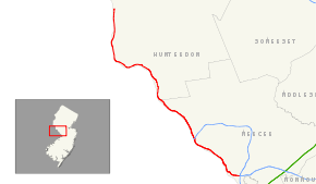
Route information Maintained by NJDOT and Hunterdon County Length: 34.76 mi[1] (55.94 km) Existed: 1927 – present Major junctions South end: 
 I-195 / I-295 in Hamilton Township
 Route 129 in Hamilton Township
 US 1 in Trenton
 I-95 in Ewing Township
 Route 179 in Lambertville
 US 202 in Delaware Township
North end:  Route 12 in Frenchtown
Highway system New Jersey State Highway Routes
Interstate and US←  Route 28
US 30  →
→←  Route 164
Route 166  →
→Route 29 is a state highway in the U.S. state of New Jersey. It runs 34.76 mi (55.94 km) from an intersection with Interstate 295 in Hamilton Township in Mercer County, where it continues as Interstate 195, to Route 12 (Bridge Street / Race Street) in Frenchtown, Hunterdon County. Between the southern terminus and Interstate 95, the route is a mix of freeway and four-lane divided highway that runs along the Delaware River through Trenton. This section includes a truck-restricted tunnel that was built along the river near historic houses and Riverview Cemetery. North of Interstate 95, Route 29 turns into a scenic and mostly two-lane highway, and from the South Trenton Tunnel, is designated the Delaware River Scenic Byway, a National Scenic Byway, that follows the Delaware River in mostly rural sections of Mercer County and Hunterdon County. The obsolete Delaware & Raritan Canal usually stands between the river and the highway. Most sections of this portion of Route 29 are completely shaded due to the tree canopy. Route 29 also has a spur, Route 129, which connects Route 29 to U.S. Route 1 in Trenton.
Route 29 was initially designated in 1927 to run from downtown Trenton to Newark, following present-day Route 179 and U.S. Route 202 between Lambertville and Somerville and U.S. Route 22 between Somerville and Newark. The route between Lambertville and Frenchtown was originally Route 29A. In 1953, Route 29 was shifted to follow the alignment of Route 29A to avoid the concurrencies with the U.S. Routes. Route 29 between South Warren Street in Trenton and Interstate 95 in Ewing Township was upgraded to a four-lane highway, with a portion of freeway, in the 1950s and 1960s. In 1995, the southern freeway part of Route 29 between Interstate 195/Interstate 295 and Route 129 in Hamilton Township was completed. This freeway section was linked to the rest of Route 29 by a tunnel completed in 2002. A realignment of Route 29 in Lambertville by the 2000s made the route concurrent with the entire length of 0.26 mi (0.42 km) long Route 165.
Contents
Route description
Mercer County
 Approaching the southern terminus of Route 29 where it transitions into Interstate 195 in Hamilton Township.
Route 29 begins at a modified cloverleaf interchange with Interstate 195 and Interstate 295 in Hamilton Township, and it serves as the western continuation of Interstate 195, heading to the northwest as a six-lane freeway. The route interchanges with Route 129, a spur of Route 29 which connects to U.S. Route 1, at a partial interchange with a northbound exit and southbound entrance.[1] Route 29 narrows to four lanes past this interchange and crosses into Trenton. The route comes to a southbound exit and entrance for Lamberton Road. At this point, Route 29 becomes the Delaware River Scenic Byway, a state scenic byway that was also designated a National Scenic Byway in 2009.[2][3] Route 29 runs along the bank of the Delaware River and enters a truck-restricted tunnel that passes by historic houses and Riverview Cemetery.[1][4][5] Within this tunnel, Route 29 features a southbound exit and northbound entrance for Lalor Street.[1] The route emerges from the tunnel as the John Fitch Parkway, passes by Mercer County Waterfront Park, and comes to a traffic light at Thunder Road/Cass Street where it widens back to six lanes.[1][6] Route 29 meets South Warren Street at another traffic light. The median widens and it passes under the Morrisville-Trenton Railroad Bridge, which carries the Amtrak Northeast Corridor over the Delaware River.[1]
 NJ 29 northbound in Trenton on John Fitch Parkway.
Route 29 passes under the Trenton-Morrisville Toll Bridge, which carries U.S. Route 1 over the Delaware River. Access to U.S. Route 1 southbound is provided by ramps from Route 29 while access to Route 29 from northbound U.S. Route 1 is provided by South Warren Street.[1] Route 29 passes under the Lower Trenton Bridge and the median narrows again. It interchanges with Market Street, which provides access to Route 33, and then features an interchange which provides access to the New Jersey State House with a northbound exit and southbound entrance. Route 29 crosses the Assunpink Creek and features an interchange which provides access to South Warren Street with exits in both directions but only a northbound entrance.[1] Route 29 continues to a cloverleaf interchange with Calhoun Street (County Route 653), which provides access to the Calhoun Street Bridge over the Delaware River. Riverside Avenue exits as a frontage road paralleling the northbound lanes of Route 29 before the road features a northbound exit for Hermitage Avenue. Route 29 comes to a partial interchange with Parkside Avenue, with a northbound exit and southbound entrance, and then features a northbound exit for South Eastfield Avenue.[1]
The freeway portion of Route 29 ends at the intersection with Lee Avenue and it continues northwest along the Delaware River as a four-lane divided highway. The route meets the southern terminus of County Route 579 (Sullivan Way). The median widens again and then narrows as the route meets the southern terminus of Route 175, a former alignment of Route 29 that currently serves as a frontage road. Route 29 crosses into Ewing Township and becomes the Daniel Bray Highway. It passes under the West Trenton Railroad Bridge, which carries CSX and SEPTA’s West Trenton Line line over the Delaware River.[1] Route 29 intersects Route 175 again and then comes to a complex interchange with Interstate 95, with the ramps within the median of Route 29, just to the east of the Scudder Falls Bridge.[1]
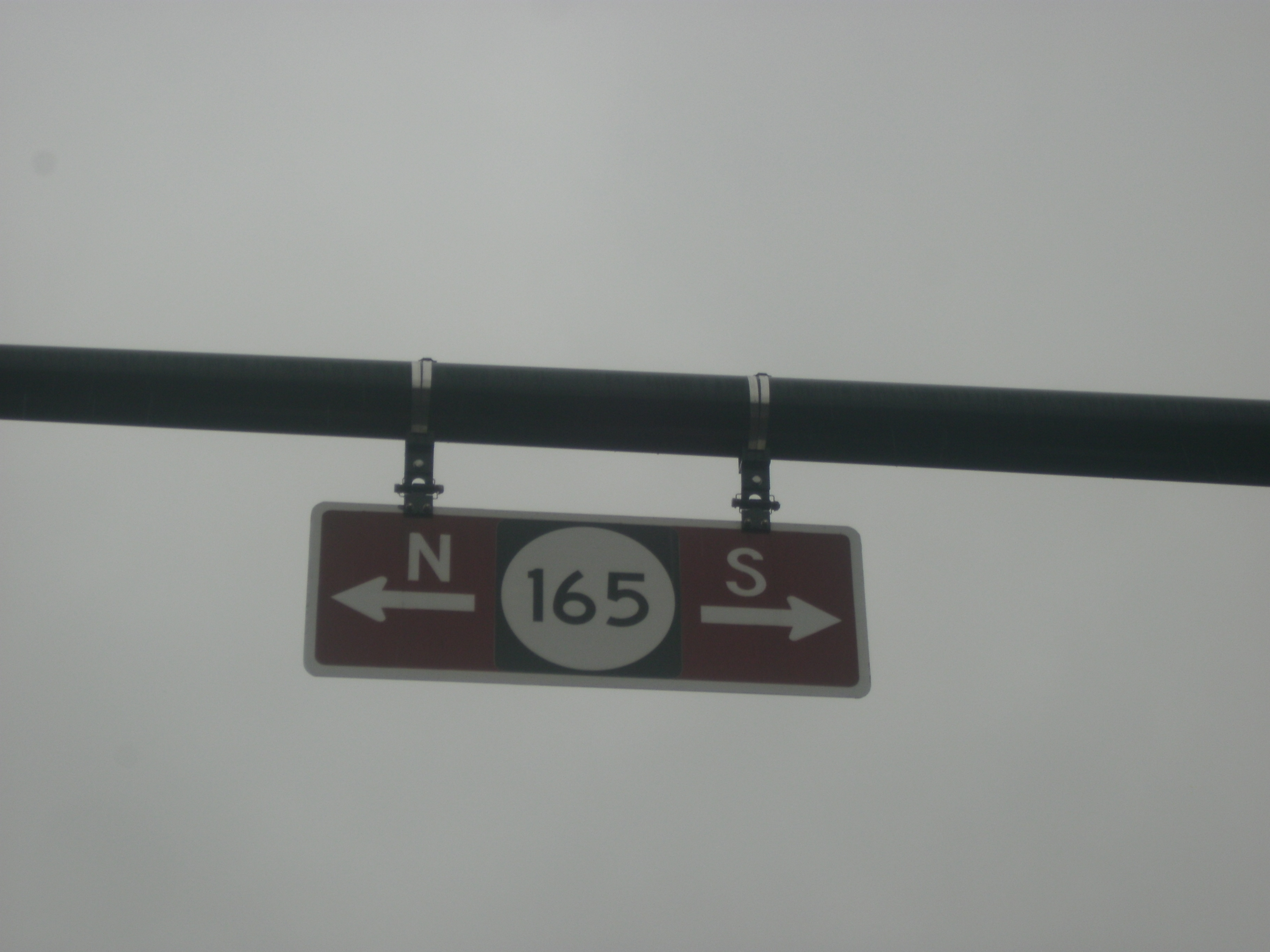
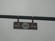 Sign blade for Route 165, which is fully concurrent with Route 29 in Lambertville
Upon crossing the Delaware and Raritan Canal, Route 29 narrows down to a two-lane undivided road called River Road. It continues along the Delaware River, next to the Delaware and Raritan Canal, which runs between Route 29 and the river. The route intersects the northern terminus of Route 175. Farther north, Route 29 enters Hopewell Township and continues into a more rural setting shaded with trees.[6] Route 29 heads to Washington's Crossing, where it intersects County Route 546, which heads east on Washington Crossing-Pennington Road, and the approach to the Washington Crossing Bridge, which continues into Pennsylvania as Pennsylvania Route 532.[1][6] Route 29 continues north along the Delaware River through Titusville, passing by Washington Crossing State Park.[6]
Hunterdon County
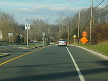 Route 29 northbound after leaving downtown Lambertville, approaching U.S. Route 202
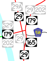
Route 29 crosses into West Amwell Township in Hunterdon County. It enters Lambertville, where Route 29 becomes a four-lane divided highway.[1] At the intersection of South Main Street, Route 29 becomes concurrent with Route 165.[7] The route becomes an undivided highway again and meets the western terminus of County Route 518 (Brunswick Street). It meets Route 179 (Bridge Street), where Route 165 ends and Route 29 turns west for a one-block wrong-way concurrency with the two-lane, undivided Route 179, lasting to the intersection of Main Street, where Route 29 turns north on Main Street.[1][7]
Route 29 follows Main Street north through Lambertville, crossing into Delaware Township. It comes to an interchange with U.S. Route 202 just east of the New Hope-Lambertville Toll Bridge, with access to northbound U.S. Route 202 and from southbound U.S. Route 202 provided by way of Alexauken Creek Road.[1] Route 29 continues along the Delaware River and enters Stockton. The route intersects Bridge Street, which crosses the Delaware River on the Centre Bridge-Stockton Bridge and continues into Pennsylvania as Pennsylvania Route 263.[1][6] Shortly after that intersection, Route 29 intersects the southern terminus of County Route 523 (Stockton-Flemington Road). Route 29 crosses back into Delaware Township, where it meets the southern terminus of County Route 519 (Kingwood-Stockton Road).[1]
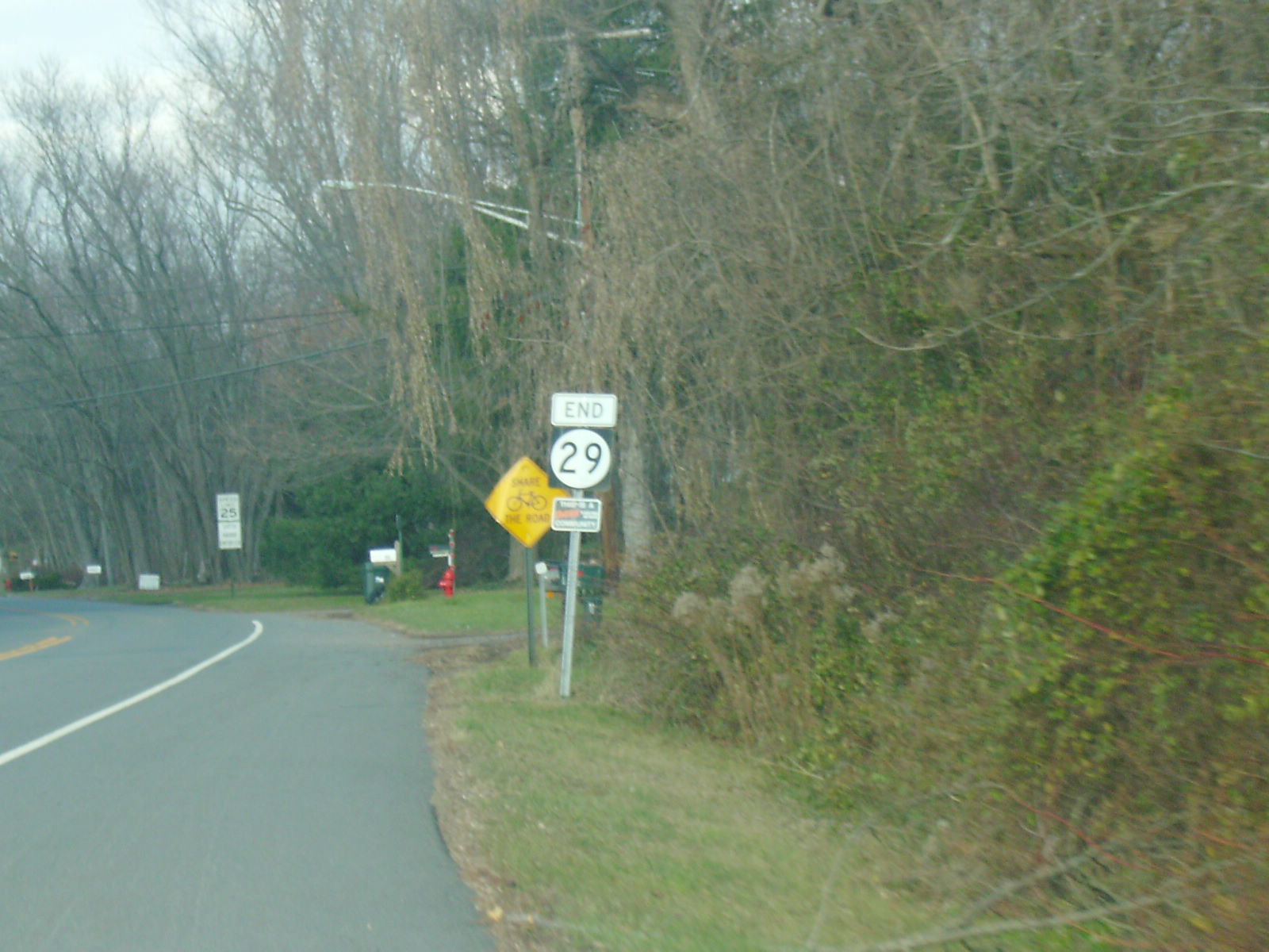
 Route 29's mis-signed northern terminus when ending Frenchtown. Route 29 continues to Frenchtown and Route 12 despite the signage.
Route 29 makes a sharp left turn and heads west along the river as a rural road, crossing into Kingwood Township, where the name of the road changes from Main Street to Daniel Bray Highway. Here, it intersects with County Route 651 (Byram-Kingwood Road). The route bends to the north and continues along the Delaware River for several miles, crossing into Frenchtown, where the route becomes Trenton Road.[1] Upon entering Frenchtown, an end shield for northbound Route 29 is posted to mark the end of state maintenance, which officially ends at the Washington Street intersection, where maintenance is transferred to the county.[1][8] Despite this, Route 29 officially continues farther north along Trenton Road to its northern terminus at Route 12 (Bridge Street/Race Street), a short distance east of Route 12’s western terminus at the Uhlerstown-Frenchtown Bridge. The southern terminus of County Route 513 is located a block north of the northern terminus of Route 29 along Route 12.[1]
History
 A map showing the history of numbered routes in Lambertville.
The current route was originally legislated in 1911 as part of the Delaware River Drive, a named state highway that was proposed to run from along the Delaware River from Trenton to the New York border in Montague Township.[9] Route 29 was originally defined in 1927 to run from Trenton to Newark. The original route ran from downtown Trenton along State Street and Sanhican Drive. From there, it followed its current alignment to Lambertville, where it followed present-day Route 179 to Ringoes to present-day County Route 514, which it followed to Woods Tavern. The route turned north on U.S. Route 206 (also designated Route 31) and followed that route to Somerville, where it followed U.S. Route 22 to Newark. The current alignment of Route 29 from Lambertville to Route 12 in Frenchtown was designated Route 29A in 1927.[10][11]
 Route 29A (1927-1953)
The alignment of Route 29 between Ringoes and Somerville was eventually shifted to follow present-day U.S. Route 202, which was also Route 30 (now Route 31) between Ringoes and Flemington and Route 12 between Flemington and Somerville.[12] In 1938, Route 29B was planned as an extension of Route 29A from Frenchtown to Route 28 (now Route 122) in Alpha. While this road was never built, much of the alignment north of Milford is served by County Route 519.[13] In 1948, a spur route, Route S29, was created, running along U.S. Route 202 (Bridge Street) in Lambertville to the New Hope-Lambertville Bridge.[14]
 Route 29B (planned in 1938)
In the 1953 New Jersey state highway renumbering, Route 29 was redefined to continue north from Lambertville to Frenchtown on Route 29A, and the Route 29 designation between Lambertville and Newark was removed in favor of U.S. Route 202 between Lambertville and Somerville and U.S. Route 22 between Somerville and Newark. The section of former Route 29 between Route 29A and Route S29 became Route 165.[15]
Plans for a limited-access route along the Route 29 corridor go back to 1932, when a parkway was proposed along the Delaware River between Trenton and Lambertville; this proposal never materialized.[16] Plans for a freeway were resurrected in the early 1950s to construct a road, the John Fitch Parkway, that was to run from Hamilton Township to Interstate 95 in Ewing Township. This road was built between 1954 and 1957 from South Warren Street in Trenton to present-day Interstate 95 in Ewing Township. Construction of this portion John Fitch Parkway took up much of Trenton’s available waterfront along the Delaware River.[16] The former alignment of Route 29 in the northern part of Trenton and in Ewing Township became Route 175.[17]
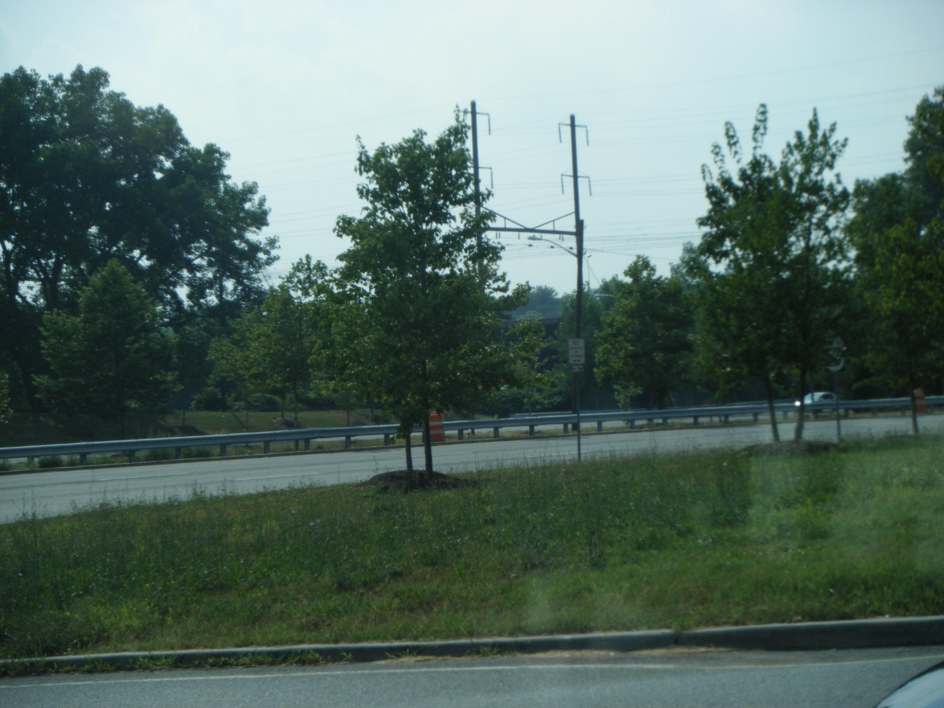
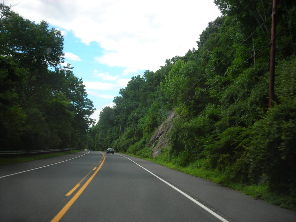
 Route 29 northbound in Hunterdon County
Between 1990 and 1995, the Route 29 freeway was built between the Interstate 195/Interstate 295 interchange and Route 129 in Hamilton Township.[16] A two-lane street, Lamberton Road, connected the two freeway sections. Plans were then made to fill the gap between the two freeway sections in Trenton. Construction began in 1997 on the Route 29 freeway between Route 129 and the Morrisville-Trenton Railroad Bridge. The road was to include two traffic lights at Cass Street and South Warren Street and a tunnel which was to be built as a covered roadway on the bank of the Delaware River.[16] The tunnel was originally scheduled to be complete by 2001 but was delayed after the Army Corps of Engineers discovered many environmental violations that occurred with construction of the tunnel.[16] The roof was put in place in October 2001 and the tunnel officially opened to traffic on March 2, 2002. A restriction to trucks over 13 tons was put in place and made permanent in November 2002.[16] In 2003, construction of a waterfront park above the Route 29 tunnel was completed, rendering access to the Delaware River waterfront for the southern part of Trenton.[16]
By the 2000s, the state gave the part of Route 29 (South Main Street) between Route 165 and Route 179 in Lambertville to the city, and Route 29 was rerouted to use all of Route 165 and one block of Route 179. Prior to this, South Main Street had been turned one-way southbound.[18] Route 165, which is only signed on overhead street signs, still exists, though it is fully concurrent with Route 29.[7]
Major intersections
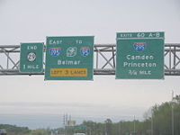
County Location Mile[1] Destinations Notes Mercer Hamilton Township 0.00  I-295 / I-195 east to I-95 / NJ Turnpike – Camden, Princeton, Belmar
Southern terminus; Continues as I-195; I-295 exit 60 1.64 Route 129 north (Canal Boulevard) – TrentonNorthbound exit S. Lamberton Road – Duck Island Trenton 1.77 S. Lamberton Road – Duck Island Southbound exit 2.56  CR 650 east (Lalor Street)
3.37 US 1 south – Morrisville3.63  To Route 33 (Market Street)
3.84 Memorial Drive – Capitol Complex 4.34  CR 653 north (Calhoun Street) – Capitol Complex, Morrisville
4.81 Riverside Avenue Northbound exit 5.01 Hermitage Avenue Northbound exit 5.45 Parkside Avenue – Cadwalder Park Northbound exit 5.60 S. Eastfield Avenue Northbound exit North end of freeway 6.18  CR 579 north (Sullivan Way)
6.74  Route 175 north (Sanhican Drive)
Ewing Township 8.49 Route 175 (West Upper Ferry Road)9.13 I-95Interchange; I-95 exit 1 9.55 Route 175 southHopewell Township 11.95  CR 546 east (Washington Crossing-Pennington Road)
Hunterdon Lambertville 18.60 Route 165South end of NJ 165 overlap 18.77  CR 518 east (Brunswick Street)
18.87 Route 179 north (Bridge Street)North end of NJ 165 overlap, south end of NJ 179 overlap 18.89 Route 179 south (Bridge Street)North end of NJ 179 overlap Delaware Township 20.06 US 202Interchange Stockton 22.48  CR 523 north (Stockton-Flemington Road)
Delaware Township 23.03  CR 519 north (Kingwood-Stockton Road)
Frenchtown 34.71 Route 12 (Bridge Street/Race Street)Northern terminus 1.000 mi = 1.609 km; 1.000 km = 0.621 mi See also
 U.S. Roads portal
 New Jersey portal
References
- ^ a b c d e f g h i j k l m n o p q r s t u "Route 29 straight line diagram". New Jersey Department of Transportation. http://www.state.nj.us/transportation/refdata/sldiag/00000029__-.pdf. Retrieved 2008-10-22.
- ^ "Delaware River Scenic Byway". National Scenic Byways Program. http://www.byways.org/explore/byways/2463/index.html. Retrieved 2008-10-27.
- ^ "Delaware River Scenic Byway - Official Designations". National Scenic Byways Program. http://www.byways.org/explore/byways/2463/designation.html. Retrieved 2010-11-06.
- ^ "NJDOT Traffic Regulations - Weight Limit - Route 29". New Jersey Department of Transportation. http://www.state.nj.us/transportation/refdata/traffic_orders/weightlimits/rt29.shtm. Retrieved 2008-10-27.
- ^ "CSD Case Study No. 9 - Route 29 through Trenton, New Jersey". Context Sensitive Design. http://128.163.152.205/csd/PDF/CSD9Route29NJ.pdf. Retrieved 2008-10-27.
- ^ a b c d e Google, Inc. Google Maps – overview of New Jersey Route 29 (Map). Cartography by Google, Inc. http://maps.google.com/maps?f=d&source=s_d&saddr=I-295+%26+I-195&daddr=route+29+and+route+12+frenchtown,+nj&geocode=CRKsrKUu0kryFSonZQIdVtWL-yGPcKn4YLmAsA%3B&hl=en&mra=pe&mrcr=0&sll=40.355337,-74.848791&sspn=0.491861,0.878906&ie=UTF8&ll=40.354917,-74.885559&spn=0.491861,0.878906&t=h&z=10. Retrieved 2009-04-01.
- ^ a b c "Route 165 straight line diagram". New Jersey Department of Transportation. http://www.state.nj.us/transportation/refdata/sldiag/00000165__-.pdf. Retrieved 2008-10-22.
- ^ Mason, Chris. "New Jersey Highway Ends-29". New Jersey Highway Ends. Archived from the original on June 24, 2008. http://web.archive.org/web/20080624232817/http://www.njroads.org/ends/29/nj29.htm. Retrieved 2008-10-24.
- ^ State of New Jersey, Laws of 1911, Chapter 114
- ^ State of New Jersey, Laws of 1927, Chapter 319.
- ^ Williams, Jimmy and Sharon. "1927 New Jersey Road Map". 1920s New Jersey Highways. http://www.jimmyandsharonwilliams.com/njroads/1920s/images/1927_routes.gif. Retrieved 2008-10-08.
- ^ Mid-West Map Co. (1941). Map of Pennsylvania and New Jersey (Map). Cartography by H.M. Gousha. http://www.mapsofpa.com/roadcart/1941_1467m.jpg. Retrieved 2009-03-29.
- ^ State of New Jersey, Laws of 1938, Chapter 183.
- ^ State of New Jersey, Laws of 1948, Chapter 407.
- ^ 1953 renumbering. New Jersey Department of Highways. http://en.wikisource.org/wiki/1953_New_Jersey_state_highway_renumbering. Retrieved July 31, 2009.
- ^ a b c d e f g Anderson, Steve. "NJ 29 Freeway". Eastern Roads. http://www.nycroads.com/roads/NJ-29/. Retrieved 2008-10-24.
- ^ Chevron Oil Company (1969). Map of New Jersey (Map). Cartography by H.M. Gousha.
- ^ "NJDOT Traffic Regulations - One Way Street - Route 29". New Jersey Department of Transportation. http://www.state.nj.us/transportation/refdata/traffic_orders/one_way/rt29.shtm. Retrieved 2009-04-01.
External links
- An enlarged view of road jurisdiction in Trenton at the confluence of US 1, US 206, NJ 29, NJ 33 and NJ 129
- An enlarged view of road jurisdiction in Ewing Township at the confluence of I-95, NJ 29 and NJ 175
- An enlarged view of road jurisdiction in Lambertville at the confluence of NJ 29, NJ 165, NJ 179 and CR 518
- New Jersey Roads: Route 29
- New Jersey Highway Ends: 29
- Speed Limits for Route 29
Controlled-access highways and Expressways in New Jersey Interstate Highways U.S. and state highways Toll roads and other highways Atlantic City Expressway (Brigantine Connector) • Garden State Parkway • New Jersey Turnpike • Palisades Interstate ParkwayCategories:- State highways in New Jersey
- Transportation in Hunterdon County, New Jersey
- Transportation in Mercer County, New Jersey
- Trenton, New Jersey
- Limited access New Jersey state routes
- National Scenic Byways


Wikimedia Foundation. 2010.