- Montague Township, New Jersey
-
Montague Township, New Jersey — Township — Map of Montague Township in Sussex County. Inset: Location of Sussex County highlighted in the State of New Jersey.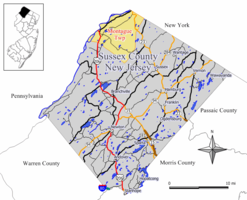 Census Bureau map of Montague Township, New Jersey.
Coordinates: 41°18′13″N 74°44′57″W / 41.30361°N 74.74917°WCoordinates: 41°18′13″N 74°44′57″W / 41.30361°N 74.74917°W Country United States State New Jersey County Sussex Incorporated February 21, 1798 Government – Type Township (New Jersey) – Mayor Joe Barnagallo Area – Total 45.3 sq mi (117.4 km2) – Land 44.0 sq mi (114.0 km2) – Water 1.3 sq mi (3.4 km2) Elevation 1,201 ft (366 m) Population (2000) – Total 3,412 – Density 77.5/sq mi (29.9/km2) Time zone Eastern (EST) (UTC-5) – Summer (DST) EDT (UTC-4) ZIP code 07827 Area code(s) 973 Exchanges: 293, 948 FIPS code 34-47430[1][2] GNIS feature ID 0882256[3] Website http://www.montaguenj.org Montague Township is a Township in Sussex County, New Jersey, United States. As of the United States 2000 Census, the township population was 3,412.
Montague Township was supposedly named after the George Montagu, 4th Duke of Manchester, as suggested by King George II, who approved the royal patent on March 26, 1759.[4] Montague was incorporated as one of New Jersey's initial group of 104 townships by an Act of the New Jersey Legislature on February 21, 1798.[5]
Contents
Geography
Montague Township contains both the northernmost point and highest elevation (1803 ft/550 m) in New Jersey. According to the United States Census Bureau, the township has a total area of 45.3 square miles (117.4 km²), of which, 44.0 square miles (114.0 km²) of it is land and 1.3 square miles (3.4 km²) of it (2.93%) is water.
Demographics
Historical populations Census Pop. %± 1930 581 — 1940 621 6.9% 1950 602 −3.1% 1960 879 46.0% 1970 1,131 28.7% 1980 2,066 82.7% 1990 2,832 37.1% 2000 3,412 20.5% Est. 2008 3,906 [6] 14.5% Population 1930 - 1990.[7] As of the census[1] of 2000, there were 3,412 people, 1,286 households, and 910 families residing in the township. The population density was 77.5 people per square mile (29.9/km²). There were 1,588 housing units at an average density of 36.1 per square mile (13.9/km²). The racial makeup of the township was 95.25% White, 1.79% African American, 0.18% Native American, 0.67% Asian, 1.08% from other races, and 1.03% from two or more races. Hispanic or Latino of any race were 3.28% of the population.
There were 1,286 households out of which 34.9% had children under the age of 18 living with them, 57.4% were married couples living together, 8.2% had a female householder with no husband present, and 29.2% were non-families. 23.2% of all households were made up of individuals and 7.5% had someone living alone who was 65 years of age or older. The average household size was 2.65 and the average family size was 3.14.
In the township the population was spread out with 27.2% under the age of 18, 6.4% from 18 to 24, 31.2% from 25 to 44, 24.1% from 45 to 64, and 11.1% who were 65 years of age or older. The median age was 37 years. For every 100 females there were 107.0 males. For every 100 females age 18 and over, there were 102.5 males.
The median income for a household in the township was $45,368, and the median income for a family was $50,833. Males had a median income of $39,569 versus $25,221 for females. The per capita income for the township was $20,676. About 8.5% of families and 12.0% of the population were below the poverty line, including 18.1% of those under age 18 and 6.3% of those age 65 or over.
Surrounding communities

Westfall Twp, PA State border between Pennsylvania and New York Deerpark, NY and Greenville, NY Dingman Twp, PA and Milford, PA 
 Montague Twp

Sandyston Twp Frankford Twp Wantage Twp Transportation
One U.S., state, and county route traverse the township. U.S. Route 206 passes through in the western part and crosses the Delaware River at the Milford-Montague Toll Bridge. Route 23 passes through the eastern part and serves as the entrance road to High Point State Park and ends at the New York border just south of I-84. County Route 521 passes through the northwest and ends at the New York state boundary.
The closest limited access road is Interstate 84 (which used to be part of the New York State Thruway until October 2010) and it is immediately over the state line in Deerpark, New York.
In the northernmost section of the township along Route 23, there are several gasoline stations, most likely because gas is significantly less expensive in New Jersey than in Matamoras, Pennsylvania or Port Jervis, New York.
The township does not have a traffic light.
Government
Local government
Montague Township is governed under the Township form of government with a five-member Township Committee. The Township Committee is elected directly by the voters in partisan elections to serve three-year terms of office on a staggered basis, with one or two seats coming up for election each year.[8] At an annual reorganization meeting, the Township Committee selects one of its members to serve as Mayor and another as Deputy Mayor.
As of 2011[update], members of the Montague Township Committee are Mayor Joe Barbagallo, Deputy Mayor George Zitone, Paul Brislin, Richard Innella and Darren Ponce.[9]
Federal, state and county representation
Montague Township is in the 5th Congressional district. New Jersey's Fifth Congressional District is represented by Scott Garrett (R, Wantage Township). New Jersey is represented in the United States Senate by Frank Lautenberg (D, Cliffside Park) and Bob Menendez (D, Hoboken).
Montague is in the 24th Legislative District of the New Jersey Legislature, which is represented in the New Jersey Senate by Steve Oroho (R, Franklin) and in the New Jersey General Assembly by Gary R. Chiusano (R, Augusta) and Alison Littell McHose (R, Franklin).[10]
Sussex County is governed by a Board of Chosen Freeholders whose five members are elected at-large on a staggered basis, with one or two seats coming up for election each year. As of 2011, Sussex County's Freeholders are Freeholder Director Richard A. Zeoli (R, term ends December 31, 2012; Byram Township)[11], Deputy Director Susan M. Zellman (R, 2012; Stanhope)[12], Phillip R. Crabb (R, 2011; Franklin)[13], Parker Space (R, 2013; Wantage Township)[14] and Richard Vohden (R, 2013; Green Township).[15][16]
Politics
As of March 23, 2011, out of a 2010 Census population of 3,847 in Montague, there were 2,448 registered voters (63.6% of the population, vs. 65.8% in all of Sussex County). Of registered voters, 328 (13.4% vs. 16.5% countywide) were registered as Democrats, 1,247 (50.9% vs. 39.3% countywide) were registered as Republicans and 870 (35.5% vs. 44.1% countywide) were registered as Undeclared. There were three voters registered to other parties (one Conservative, one Green and one Libertarian).[17]
On the national level, Montague is a stronghold for the Republican Party. In the 2004 presidential election, Republican George W. Bush received 69% of the vote here, defeating Democrat John Kerry, who received 30%.[18] In the 2008 presidential election , Republican John McCain received 65% of the vote here, defeating Democrat Barack Obama, who received 33%.[19] This gives Montague Township a Cook PVI of R+19.
Education
Students in grades K - 6 attend the Montague Township School District, which served 292 students as of the 2008-09 school year.[20] For the grades above that, they cross state lines to attend middle school and high school in nearby Port Jervis, New York.
Students may also enroll at Sussex County Technical School, which accepts students on a selective basis, and to the middle school charter program in Sparta Township.[21]
References
- ^ a b "American FactFinder". United States Census Bureau. http://factfinder.census.gov. Retrieved 2008-01-31.
- ^ A Cure for the Common Codes: New Jersey, Missouri Census Data Center. Accessed July 14, 2008.
- ^ "US Board on Geographic Names". United States Geological Survey. 2007-10-25. http://geonames.usgs.gov. Retrieved 2008-01-31.
- ^ History of Montague, accessed April 8, 2006.
- ^ "The Story of New Jersey's Civil Boundaries: 1606-1968", John P. Snyder, Bureau of Geology and Topography; Trenton, New Jersey; 1969. p. 231.
- ^ Census data for Montague township, Sussex County, New Jersey, United States Census Bureau, accessed August 2, 2007.
- ^ New Jersey Resident Population by Municipality: 1930 - 1990, Workforce New Jersey Public Information Network. Accessed March 1, 2007.
- ^ 2005 New Jersey Legislative District Data Book, Rutgers University Edward J. Bloustein School of Planning and Public Policy, April 2005, p. 110.
- ^ Township Offices, Departments and Committees, Township of Montague. Accessed January 5, 2009.
- ^ "Legislative Roster: 2010-2011 Session". New Jersey Legislature. http://www.njleg.state.nj.us/members/roster.asp. Retrieved 2010-08-04.
- ^ Richard A. Zeoli, Sussex County, New Jersey. Accessed January 6, 2011.
- ^ Susan M. Zellman, Sussex County, New Jersey. Accessed January 6, 2011.
- ^ Phillip R. Crabb, Sussex County, New Jersey. Accessed January 6, 2011.
- ^ Parker Space, Sussex County, New Jersey. Accessed January 6, 2011.
- ^ Richard A. Vohden, Sussex County, New Jersey. Accessed January 6, 2011.
- ^ Sussex County Board of Chosen Freeholders, Sussex County, New Jersey. Accessed January 6, 2011.
- ^ "http://www.state.nj.us/state/elections/election-results/2011-sussex-co-summary-report.pdf
- ^ http://www.state.nj.us/state/elections/election-results/presidential_sussex_co_2004.pdf
- ^ http://www.state.nj.us/state/elections/election-results/08-gen-elect-presidential-results-sussex.pdf
- ^ District information for the Montague School District, National Center for Education Statistics. Accessed March 7, 2011.
- ^ Montague Township School District 2010 District Narrative, New Jersey School Report Card. Accessed March 7, 2011. "Children in grades seven through twelve attend Port Jervis City School District in New York, Sussex County Charter School or Sussex County Technical Institute in New Jersey."
External links
- Montague Township website
- Montague Township School District
- Montague Township School District's 2009–10 School Report Card from the New Jersey Department of Education
- Data for the Montague Township School District, National Center for Education Statistics
Municipalities and communities of Sussex County, New Jersey Boroughs Andover | Branchville | Franklin | Hamburg | Hopatcong | Ogdensburg | Stanhope | Sussex
Town Townships CDPs Unincorporated
communitiesCategories:- Townships in Sussex County, New Jersey


Wikimedia Foundation. 2010.