- Walpack Township, New Jersey
Infobox Settlement
official_name = Walpack Township, New Jersey
settlement_type = Township
nickname =
motto =
imagesize =
image_caption =
image_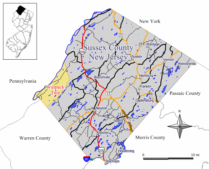
mapsize = 250x200px
map_caption = Map of Walpack Township in Sussex County. Inset: Location of Sussex County highlighted in the State of New Jersey.
mapsize1 = 250x200px
map_caption1 = Census Bureau map of Walpack Township, New Jerseysubdivision_type = Country
subdivision_name =United States
subdivision_type1 = State
subdivision_name1 =New Jersey
subdivision_type2 = County
subdivision_name2 = Sussex
government_footnotes =
government_type =Township (New Jersey)
leader_title =Mayor
leader_name = Raymond J. Fuller
leader_title1 =
leader_name1 =
established_title = Earliest mention
established_date =October 26 ,1731
established_title1 = Incorporated
established_date1 =February 21 ,1798 unit_pref = Imperial
area_footnotes =
area_magnitude =
area_total_km2 = 64.0
area_land_km2 = 62.3
area_water_km2 = 1.7
area_total_sq_mi = 24.7
area_land_sq_mi = 24.1
area_water_sq_mi = 0.6population_as_of = 2006
population_footnotes =
population_total = 40
population_density_km2 = 0.7
population_density_sq_mi = 1.7timezone = Eastern (EST)
utc_offset = -5
timezone_DST = EDT
utc_offset_DST = -4
elevation_footnotes = [Gnis|882259|Township of Walpack,Geographic Names Information System . AccessedJune 13 ,2008 .]
elevation_m = 444
elevation_ft = 1457
latd = 41 |latm = 7 |lats = 32 |latNS = N
longd = 74 |longm = 54 |longs = 44 |longEW = Wpostal_code_type =
ZIP code
postal_code = 07881 - Walpack Center
area_code = 908
blank_name = FIPS code
blank_info = 34-76640GR|2 [ [http://mcdc2.missouri.edu/webrepts/commoncodes/ccc_nj.html A Cure for the Common Codes: New Jersey] , Missouri Census Data Center. AccessedJuly 14 ,2008 .]
blank1_name = GNIS feature ID
blank1_info = 0882259GR|3
website =
footnotes =Walpack Township is a Township in Sussex County,
New Jersey ,United States . As of theUnited States 2000 Census , the township population was 41. Walpack Township is one of only four municipalities in New Jersey with a double-digit population, and it places fourth behind Tavistock (population 24) and Pine Valley (population 20), both in Camden County, and New Jersey's least populous Teterboro in Bergen County with a population of 18. [ [http://factfinder.census.gov/servlet/GCTTable?_bm=y&-geo_id=04000US34&-_box_head_nbr=GCT-PH1-R&-ds_name=DEC_2000_SF1_U&-_lang=en&-format=ST-7S&-_sse=on New Jersey -- Place and County Subdivision - GCT-PH1-R. Population, Housing Units, Area, and Density (geographies ranked by total population): 2000] ,United States Census Bureau . AccessedJune 25 ,2008 .]Walpack Township dates back to
October 26 ,1731 , when it was first mentioned as "Walpake" in Hunterdon County. The area covered by the present-day township was set off to Morris County upon that county's creation in 1739, and became part of the newly-formed Sussex County in 1753. As ofApril 15 ,1754 , Walpack's boundaries were defined as a "precinct". Walpack was formally incorporated as a township by an Act of theNew Jersey Legislature onFebruary 21 ,1798 . Portions of the township were taken to form Montague Township (March 26 ,1759 ), Sandyston Township (February 26 ,1762 ) and the now-defunct Pahaquarry Township in Warren County (December 27 ,1824 )."The Story of New Jersey's Civil Boundaries: 1606-1968", John P. Snyder, Bureau of Geology and Topography; Trenton, New Jersey; 1969. p. 232.]The current Walpack Township is named from a corruption of the
Lenape Native American word "wahlpeck," which means "turn-hole," or an eddy orwhirlpool . This word is a compound of two Native American words, "woa-lac" (a hole), and "tuppeck" (a pool). [Snell, James P. (1881) "History of Sussex and Warren Counties, New Jersey, With Illustrations and Biographical Sketches of its Prominent Men and Pioneers". (Centennial ed., Harmony, NJ: Harmony Press, 1981, pgs. 314, 326.]"
New Jersey Monthly " magazine ranked Walpack Township as its 18th best place to live in its 2008 rankings of the "Best Places To Live" in New Jersey. [ [http://njmonthly.com/articles/best_of/placestolive/best-places-to-live---the-complete-top-towns-list-.html "Best Places To Live - The Complete Top Towns List 1-100"] , "New Jersey Monthly ",February 21 ,2008 . AccessedFebruary 24 ,2008 .]Geography
According to the
United States Census Bureau , the township has a total area of 24.7square mile s (64.0km² ), of which, 24.1 square miles (62.3 km²) of it is land and 0.6 square miles (1.7 km²) of it (2.63%) is water.Demographics
USCensusPop
1930=178
1940=207
1950=204
1960=248
1970=384
1980=150
1990=67
2000=41
estimate= 40
estyear=2006
estref= [http://factfinder.census.gov/servlet/SAFFPopulation?_event=Search&_name=walpack&_state=&_county=walpack&_cityTown=walpack&_zip=&_sse=on&_lang=en&pctxt=fph Census data for Walpack township] ,United States Census Bureau . AccessedJune 25 ,2008 .]
footnote=Population 1930 - 1990. [ [http://www.wnjpin.net/OneStopCareerCenter/LaborMarketInformation/lmi01/poptrd6.htm New Jersey Resident Population by Municipality: 1930 - 1990] , Workforce New Jersey Public Information Network. AccessedMarch 1 ,2007 .] As of thecensus GR|2 of 2000, there were 41 people, 20 households, and 12 families residing in the township. Thepopulation density was 1.7 people per square mile (0.7/km²). There were 34 housing units at an average density of 1.4/sq mi (0.5/km²). The racial makeup of the township was 100.00% White.There were 20 households out of which 20.0% had children under the age of 18 living with them, 50.0% were married couples living together, 10.0% had a female householder with no husband present, and 40.0% were non-families. 40.0% of all households were made up of individuals and 10.0% had someone living alone who was 65 years of age or older. The average household size was 2.05 and the average family size was 2.75.
In the township the population was spread out with 19.5% under the age of 18, 2.4% from 18 to 24, 19.5% from 25 to 44, 31.7% from 45 to 64, and 26.8% who were 65 years of age or older. The median age was 49 years. For every 100 females there were 95.2 males. For every 100 females age 18 and over, there were 106.3 males.
The median income for a household in the township was $22,250, and the median income for a family was $22,250. Males had a median income of $46,250 versus $0 for females. The
per capita income for the township was $17,624. None of the population and none of the families were below thepoverty line .Government
Local government
Walpack Township is governed under the Township form of government with a three-member Township Committee. The Township Committee is elected directly by the voters in partisan elections to serve three-year terms of office on a staggered basis, with one seat coming up for election each year. ["2005 New Jersey Legislative District Data Book",
Rutgers University Edward J. Bloustein School of Planning and Public Policy , April 2005, p. 110.] At an annual reorganization meeting, the Township Committee selects one of its members to serve as Mayor.Members of the Walpack Township Committee are
Mayor Raymond J. Fuller (term endsDecember 31 ,2007 ), James Heigis (2006) and Joseph A. Maglio (2008) [ [http://www.sussex.nj.us/Cit-e-Access/webpage.cfm?TID=7&TPID=1113 Sussex County webpage for Walpack Township] , Sussex County,New Jersey . AccessedJune 25 ,2008 . Page still shows 2006 and 2007 term-end dates for committee members as of date accessed.]Federal, state and county representation
Walpack Township is in the Fifth Congressional District and is part of New Jersey's 24th Legislative District [ [http://www.lwvnj.org/pubs/CG06.pdf 2006 New Jersey Citizen's Guide to Government] , New Jersey
League of Women Voters , p. 65. AccessedAugust 30 ,2006 .]Education
Students in Kindergarten through sixth grade attend the schools of the
Sandyston-Walpack Consolidated School District , together with students from Sandyston Township. [ [http://education.state.nj.us/rc/rc07/narrative/37/4650/37-4650-000.html Sandyston-Walpack School District 2007 Report Card Narrative] ,New Jersey Department of Education . AccessedJune 25 ,2008 . "The Sandyston-Walpack School District is both small and rural, serving the K-6 population of 180 students living in Sandyston and Walpack Townships."] The school is located in Layton. As of the 2005-06 school year, the school had an enrollment of 177 students and 17.5 classroom teachers (on an FTE basis), for a student-teacher ratio of 10.1. [http://nces.ed.gov/ccd/schoolsearch/school_detail.asp?Search=1&DistrictID=3414610&ID=341461005392 Sandyston-Walpack Consolidated School] ,National Center for Education Statistics . AccessedJune 25 ,2008 .]The students of middle and high school age attend
Kittatinny Regional High School in Hampton Township, which serves 1,300 students who reside in Fredon Township, Hampton Township, Sandyston Township, Stillwater Township and Walpack Township. [ [http://education.state.nj.us/rc/rc07/narrative/37/2465/37-2465-000.html Kittatiny Regional School District 2007 Report Card Narrative] ,New Jersey Department of Education . AccessedFebruary 25 ,2008 . "Located in beautiful, rural Sussex County in northwest New Jersey, Kittatinny Regional School District serves the five municipalities of Fredon Township, Hampton Township, Sandyston Township, Stillwater Township and the Township of Walpack."] The high school is in Hampton, about 7 minutes outside of theCounty seat of Newton.References
External links
* [http://www.sussex.nj.us/Cit-e-Access/webpage.cfm?TID=7&TPID=1113 Web page for Walpack Township] ,
Sussex County, New Jersey
* [http://users.tellurian.net/sws/ Sandyston-Walpack Consolidated School]
*NJReportCard|37|4650|050|Sandyston-Walpack Consolidated School
* [http://nces.ed.gov/ccd/schoolsearch/school_list.asp?Search=1&DistrictID=3414610 Data for Sandyston-Walpack Consolidated School] ,National Center for Education Statistics
* [http://www.krhs.net/ Kittatinny Regional High School]
Wikimedia Foundation. 2010.