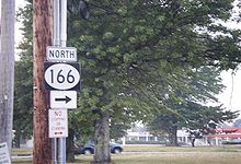
- New Jersey Route 166
-
Route 166
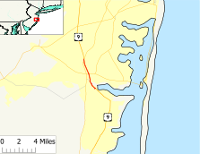
Map of Route 166, which is highlighted in red.Route information Maintained by NJDOT Length: 3.73 mi[1] (6.00 km) Existed: 1954 – present Major junctions South end:  US 9 in Beachwood
 Route 37 in Toms River
North end:  US 9 / G.S. Pkwy. Toms River
Highway system New Jersey State Highway Routes
Interstate and US←  Route 165
Route 167  →
→Route 166 is a short, 3.73-mile (6.00 km) state highway in Ocean County, New Jersey. The route provides an alternate alignment of U.S. Route 9 through South Toms River and Toms River. The southern terminus is at an intersection with U.S. Route 9 northbound in Beachwood, where it heads northward along Atlantic City Boulevard. The route continues until ending where U.S. Route 9 leaves the Parkway north of Toms River. US 9 itself uses the Garden State Parkway to bypass Toms River.
Route 166 is a former alignment of New Jersey Route 4, designated in 1920 and U.S. Route 9, designated in 1927 through Toms River. The highways were realigned when the Garden State Parkway was built, and the original alignment became U.S. Route 9 Alternate in the 1950s, which was eventually replaced with Route 166. The alignment has remained the same since.
Contents
Route description
 NJ 37 heading westbound to the intersection with Route 166
Route 166 begins at an interchange with U.S. Route 9 northbound (Atlantic City Boulevard) in the community of South Toms River. The route heads northward along the right-of-way of Atlantic City Boulevard, progressing northward along residential homes. Paralleling to the north of U.S. Route 9, Route 166 continues, passing a war memorial in the southern portion of the business district. In the center of the community, the highway intersects with Ocean County Route 621 (Admiral Avenue). There, Route 166 turns to the northeast, running along the shoreline for the Atlantic Ocean. Heading past a marina, the highway crosses on a four-lane bridge over the ocean and into Toms River.[2]
After landing down on the Toms River side, Route 166 heads to the northwest, intersecting with the incomplete Herficker Boulevard. The highway turns off its right-of-way, and crosses another branch into the center of Toms River. Passing the Riverfront Landing, Route 166 intersects with the eastern/southern terminus of County Route 527 (Water Street). The highway continues northward along commercial buildings as Main Street, passing to the west of Toms River High School and back into the residential districts. Route 166 continues northbound to an interchange with New Jersey Route 37 (Little League World Champions Boulevard) in Toms River. At the interchange, Route 166 switches names from Main Street to Lakewood Road, which heads northwestward.[2]
Route 166, after changing monikers, continues northwestward through the commercial and industrial portions of Toms River, intersecting with several local and county roads until a fork with Ocean County Route 623, where the highway forks at Riverside Cemetery. A short distance later, the highway begins a split parallel with the Garden State Parkway and U.S. Route 9 to the east. Route 166 then leaves the commercial and industrial districts for the residential ones soon later, crossing through several developments including Colonial Gardens. The highway continues northward, intersecting with Albert Avenue, where it returns to the commercial area. After an intersection with Briar Knoll, Route 166 divides, approaching Interchange 83 on the Garden State Parkway, where the designation terminates. The right-of-way continues northward as U.S. Route 9.[2]
History
The alignment of Route 166 was originally part of Route 4 prior to 1927, designated from Absecon to Rahway.[3] This designation remained in place for seven years, until the 1927 state highway renumbering, which remained part of an extended Route 4.[4] A year prior to the state highway renumbering, the alignment of Route 4 was also co-designated as part of U.S. Route 9, which had been assigned as part of a nationwide system.[5] Route 4 remained intact concurrnent with Route 9 until the state highway renumbering on January 1, 1953. On that day, Route 4 was truncated back to Fort Lee in Bergen County, and the alignment became only U.S. Route 9.[6] A bypass was built of the Route 9 alignment in the 1950s along with construction of the Garden State Parkway, which was completed soon after. The route currently Route 166 became U.S. Route 9 Alternate by 1954, remaining for several years, when it was decommissioned in place for Route 166.[7] The route has remained intact since.[8]
Major intersections
The entire route is in Ocean County.
Location Mile[1] Destinations Notes South Toms River 0.00 US 9 (Atlantic City Boulevard)1.11  CR 530 west (Main Street)
Toms River 1.15 
 CR 527 north / CR 549 north (Water Street)
1.97 Route 37 (Little League World Champions Boulevard)3.73 US 9 (Lakewood Road) / G.S. Pkwy.Interchange 83 (GSP/US 9) 1.000 mi = 1.609 km; 1.000 km = 0.621 mi See also
 U.S. Roads portal
 New Jersey portal
References
- ^ a b New Jersey Department of Transportation. "Route 166 straight line diagram". http://www.state.nj.us/transportation/refdata/sldiag/00000166__-.pdf. Retrieved October 12, 2009.
- ^ a b c Bing Maps (2009). Overview map of New Jersey Route 166 (Map). Cartography by NAVTEQ. http://www.maps.bing.com/maps/default.aspx?v=2&FORM=LMLTCP&cp=39.963471~-74.205866&style=h&lvl=14&tilt=-90&dir=0&alt=-1000&phx=0&phy=0&phscl=1&rtp=pos.39.9872484058142_-74.2108085006475_near%2083rd%2C%20Toms%20River%2C%20New%20Jersey%2008753%2C%20United%20States__~pos.39.9417869746685_-74.2011760175228_South%20Toms%20River%2C%20NJ__&rtop=0~0~0&encType=1. Retrieved October 12, 2009.
- ^ New Jersey Highway Department (1925). State Highway Route map (Map). http://www.jimmyandsharonwilliams.com/njroads/1920s/route05.htm. Retrieved October 12, 2009.
- ^ New Jersey Highway Department (1927). Sketch Map Showing Approximate Locations of State Highway Routes (Map). http://www.jimmyandsharonwilliams.com/njroads/1920s/route05.htm. Retrieved June 23, 2009.
- ^ Bureau of Public Roads, United States System of Highways, November 11, 1926
- ^ 1953 renumbering, New Jersey Department of Highways, http://en.wikisource.org/wiki/1953_New_Jersey_state_highway_renumbering, retrieved July 31, 2009
- ^ General Drafting Incorporated (1960s). Map of US 9 Alternate (Map).
- ^ New Jersey Department of Transportation (2007). New Jersey Official Road Map (Map). Cartography by New Jersey Department of Transportation.
External links
- "Speed Limits for State Roads: Route 166". New Jersey Department of Transportation. http://www.state.nj.us/transportation/refdata/traffic_orders/speed/rt166.shtm. Retrieved October 12, 2009.
- Alpert, Steve. "New Jersey Roads – History (NJ 166)". Alps Roads. http://www.alpsroads.net/roads/nj/log/9.html#166. Retrieved March 19, 2007.
Categories:- State highways in New Jersey
- Transportation in Ocean County, New Jersey


Wikimedia Foundation. 2010.