- New Jersey Route 175
-
Route 175
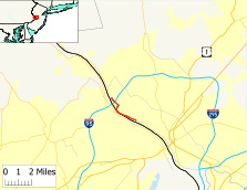
Map of Route 175, which is highlighted in red.Route information Maintained by the New Jersey Department of Transportation Length: 2.95 mi[1] (4.75 km) Existed: by 1969 – present Major junctions South end:  Route 29 in Trenton
 I-95 in Ewing
North end: Route 29 in EwingLocation Counties: Mercer Highway system New Jersey State Highway Routes
Interstate and US←  Route 174
Route 177  →
→Route 175 is a short, 2.95 miles (4.75 km) long state highway in Mercer County, New Jersey, United States. The route runs along a former alignment of New Jersey Route 29 before the construction of the John Fitch Parkway in the 1960s. The route begins at Route 29 in the capital city of Trenton, running along Sanhican Road, River Road and West Upper Ferry Road into Ewing Township. The route provides as a frontage road for Route 29 until the intersection with West Upper Ferry Road, where it turns on its own out into rural Ewing Township. For its final stretch, Route 175 heads along the Delaware and Raritan Canal until coming to an end at a merge with Route 29 in Ewing Township.
Route 175 originates as alignment of Route 29, which followed local roads after the 1927 New Jersey state highway renumbering. It remained Route 29 through the 1953 New Jersey state highway renumbering and was moved onto the John Fitch Parkway upon its completion in the 1960s. By 1969, the original alignment was designated as Route 175 and both roads have remained the same since.
Contents
Route description
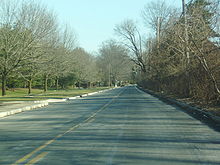 Route 175 heading southbound alongside Route 29 through Ewing Township
Route 175 begins at an offramp from New Jersey Route 29 and Aberfeldy Drive in the capital city of Trenton. The route heads northward, progressing through the northern residential districts on Sanhican Drive. The highway continues, parallelling Route 29 for a distance. At an intersection with Afton Avenue, the continuation of Aberfeldy Drive, Route 175 changes names from Sanhican Drive (which is not noted in the Straight Line Diagrams[1]) to River Road, which is also the name for Route 29. The highway continues, intersecting with Mercer County Route 643 (Lower Ferry Road) in Ewing Township. A short distance later, Routes 175 and 29 cross under a railroad viaduct along the Delaware River, passing to the south of several high-end mansions. Route 175 itself passes to the south of condominium complexes, intersecting with the access road shortly afterward.[2]
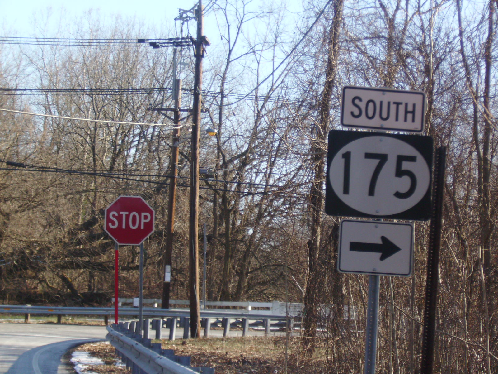
 Route 175 heading southbound (near West Trenton) at the intersection with County Route 634
A short distance later, Route 175 juts to the northeast near a commercial business, interchanging with Route 29. After the short interchange, the highway continues along the side of Route 29, intersecting with Wilburtha Road (formerly an intersection with New Jersey Route 39) in Ewing. Routes 175 and 29 continue northward, crossing through the woodlands north of Trenton, until Route 175 makes a bend to the northeast, intersecting with West Upper Ferry Road. The highway turns onto West Upper Ferry Road, heading to the northeast, crossing through a wealthy district in Ewing surrounded by woodlands. The route begins to enter fields, crossing over the Delaware and Raritan Canal on character-less bridge. After the bridge, Route 175 turns to the north onto River Road, while West Upper Ferry Road continues as Mercer County Route 634.[2]
Route 175 heads northward along the Delaware and Raritan Canal as River Road, passing through woodlands and residential homes. A short distance later, it intersects with State Police Drive, a road serving the local New Jersey State Police headquarters. Continuing along the canal, Route 175 progresses northward, intersecting with Trooper Drive before crossing under Interstate 95 at Interchange 1. Route 175 continues for a short distance, becoming a divided highway just after the overpass. A short distance later, the highway comes to end as the right-of-way continues onto Route 29.[2]
History
Route 175 is an original alignment of Route 29 through Trenton and Ewing designated in the 1927 renumbering of state highways in New Jersey.[3][4] The original plan for a freeway along Route 29 started in the 1930s, with no progress until the 1950s, when construction began on John Fitch Parkway named after John Fitch. Construction of this alignment used up much of the available waterfront in Trenton, and by 1969, after Route 29 was realigned onto the new freeway, Route 175 was designated on the former alignment.[5][6] Route 175 was designated as a No Passing Zone by the New Jersey Department of Transportation on September 14, 1982.[7] The two highways (Route 175 and Route 29) have remained intact since.[8]
Major intersections
The entire route is in Mercer County.
Location Mile[1] Destinations Notes Trenton 0.00 Route 29Southern terminus Ewing 1.42 Wilburtha Road Formerly an alignment of  Route 39
2.54 I-95Exit 1 (I-95) 2.95  NJ 29
NJ 29Northern terminus 1.000 mi = 1.609 km; 1.000 km = 0.621 mi See also
 U.S. Roads portal
 New Jersey portal
References
- ^ a b c "Route 175 straight line diagram". New Jersey Department of Transportation. 2009. http://www.state.nj.us/transportation/refdata/sldiag/00000175__-.pdf. Retrieved March 19, 2007.
- ^ a b c Bing Maps/Microsoft Inc. (2009). Overview map of NJ 175 (Map). Cartography by NAVTEQ Inc.. http://www.maps.bing.com/maps/?FORM=Z9LH8#JnJ0cD1wb3MucXE2MDVoOHJ6MTNjXzUwMitTYW5oaWNhbitEciUyYytUcmVudG9uJTJjK05KKzA4NjE4LTQ5MTZfX19lXyU3ZXBvcy5xcTY5d2Q4cnlncDFfbmVhcis3MTYrUml2ZXIrUmQlMmMrVHJlbnRvbiUyYytOZXcrSmVyc2V5KzA4NjI4JTJjK1VuaXRlZCtTdGF0ZXNfX19lXyU3ZXBvcy5xcTd0cno4cnd4dDdfbmVhcitSaXZlcitSZCUyYytUcmVudG9uJTJjK05ldytKZXJzZXkrMDg2MjglMmMrVW5pdGVkK1N0YXRlc19fX2VfJTdlcG9zLnFxOG0xMDhyeDRjZF9uZWFyKzEwMDMrUml2ZXIrUmQlMmMrVHJlbnRvbiUyYytOZXcrSmVyc2V5KzA4NjI4JTJjK1VuaXRlZCtTdGF0ZXNfX19lXyU3ZXBvcy5xcTlwcng4cndnMXhfbmVhcitSaXZlcitSZCUyYytUcmVudG9uJTJjK05ldytKZXJzZXkrMDg2MjglMmMrVW5pdGVkK1N0YXRlc19fX2VfJnJ0b3A9MCU3ZTA=. Retrieved September 23, 2009.
- ^ State of New Jersey, Laws of 1927, Chapter 319.
- ^ Williams, Jimmy and Sharon. "1927 New Jersey Road Map". 1920s New Jersey Highways. http://www.jimmyandsharonwilliams.com/njroads/1920s/images/1927_routes.gif. Retrieved September 23, 2009.
- ^ Anderson, Steve. "NJ 29 Freeway". Eastern Roads. http://www.nycroads.com/roads/NJ-29/. Retrieved September 23, 2009.
- ^ Chevron Oil Company (1969). Map of New Jersey (Map). Cartography by H.M. Gousha.
- ^ "No Passing Zones - Route 175". New Jersey Department of Transportation. 1982. pp. 1. http://www.state.nj.us/transportation/refdata/traffic_orders/nopass/rt175.shtm. Retrieved September 23, 2009.
- ^ New Jersey Department of Transportation (2007). New Jersey Official Road Map (Map). Cartography by New Jersey Department of Transportation.
External links
Categories:- State highways in New Jersey
- Transportation in Mercer County, New Jersey


Wikimedia Foundation. 2010.