- New Jersey Route 303
-
Route 303
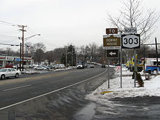
The look on the state line towards NY 303. This area in Northvale is where NJ 303 would have terminated.Route information Maintained by NJDOT Existed: 1938 – 1950s (never built) Major junctions South end:  Route 4 in Teaneck
North end:  NY 303 in Northvale
Location Counties: Bergen Highway system New Jersey State Highway Routes
Interstate and US←  Route 300
US 322  →
→Route 303 was a proposed state highway in the northeastern portion of New Jersey. The route originally was defined to go from an intersection with current-day New Jersey Route 4 in Teaneck, then progressing northward through several local communities before connecting to the New York state line at Northvale. At the state line, Route 303 was to intertwine and become the current-day New York State Route 303. The alignment runs along the current alignment of County Route 505, which becomes NY 303 at the state line.
It was first planned in 1938 as Route S4D (a spur of Route 4), and once the 1953 renumbering of highways occurred, the S-4-D designation was replaced by NJ 303. However, the highway was never assigned and remains unused to this day.
Contents
Proposed route
The proposed alignment of Route 303 was to begin at an intersection with New Jersey Route 4, a major highway in northern New Jersey, north of the community of Fort Lee. The route was to head northward along an alignment through the community of Teaneck, passing along an alignment similar to current-day County Route 505. The route was to eventually pass the New Jersey State Armory at an intersection with the proposed Liberty Road and continue northward to the New York state line at Northvale, where the 303 designation would continue northward as New York State Route 303.[1]
History
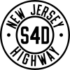 Route S4D (1938-1953)
Route 303 originated as a proposed alignment of State Highway Route S-4-D, a spur of State Highway Route 4, a cross-state highway from Cape May to Paterson. The route was assigned in 1938, proposed to follow a highway known as the Liberty Road through the community of Teaneck.[1] In 1941, the New Jersey State Legislature amended the proposal to include a highway known as the Liberty Road from Route 4 to New York State Route 303 (designated in 1930[2]) at Northvale.[3] The proposal sat around for twelve years, until January 1, 1953, when the New Jersey State Highway Department renumbered the state highways around New Jersey. As part of the renumbering, Route S-4-D was re-designated Route 303 to match up with NY 303.[4] The route, as of 2007, has never been constructed, but the general alignment remains as County Route 505.[5]
Proposed major intersections
The entire route was in Bergen County.
Location Mile Destinations Notes Teaneck Route 4Proposed southern terminus of Route 303. Northvale NY 303Proposed northern terminus of Route 303. 1.000 mi = 1.609 km; 1.000 km = 0.621 mi See also
 U.S. Roads portal
 New Jersey portal
- New Jersey Route 11
- New Jersey Route 14
References
- ^ a b "134". ROUTE NO. S-4-d. The following route which shall be an extension of State Highway Route No. 4, shall commence at Route No. 4 in Teaneck township at Teaneck road and run generally in a northerly direction to a road known as Liberty road, in the township of Teaneck, being the location of a State Armory, township of Teaneck, Bergen county, New Jersey, and to be known as S-4-d. New Jersey State Legislature. 1938. pp. 286.
- ^ Automobile Legal Association (ALA) Automobile Green Book, 1930/31 and 1931/32 editions, (Scarborough Motor Guide Co., Boston, 1930 and 1931). The 1930/31 edition shows New York state routes prior to the 1930 renumbering
- ^ "263". ROUTE NO. S-4-d. The following route which shall be an extension of State Highway Route No. 4, shall commence at Route No. 4 in Teaneck township at Teaneck road and run generally in a northerly direction to a road known as Liberty road, in the township of Teaneck, being the location of a State Armory, township of Teaneck, Bergen county, New Jersey, and to be known as S-4-d.. New Jersey State Legislature. 1941. pp. 696.
- ^ 1953 renumbering, New Jersey Department of Highways, http://en.wikisource.org/wiki/1953_New_Jersey_state_highway_renumbering, retrieved July 31, 2009
- ^ New Jersey Department of Transportation (2007). New Jersey Official Road Map (Map). Cartography by New Jersey Department of Transportation.
External links
- Moraseski, Dan; Alpert, Steve (2009). "303". Alps Roads. http://www.alpsroads.net/roads/nj/log/11.html#303. Retrieved November 12, 2009.
Unbuilt Highways in New Jersey Interstate Highways I-695 • I-895State highways Toll roads and other highways Categories:- State highways in New Jersey
- Transportation in Bergen County, New Jersey


Wikimedia Foundation. 2010.