- U.S. Route 322 in New Jersey
-
This article is about the section of U.S. Route 322 in New Jersey. For the entire length of the highway, see U.S. Route 322.
U.S. Route 322
US 322 highlighted in redRoute information Maintained by NJDOT, DRPA, and Atlantic County Length: 62.81 mi[2] (101.08 km) Existed: 1936[1] – present Major junctions West end:  US 322 on the Commodore Barry Bridge in Logan Township
 US 130 in Logan Township
 I-295 in Logan Township
 NJ Turnpike in Woolwich Township
 Route 45 in Harrison Township
 Route 55 near Glassboro
 Route 42 in Williamstown
 Route 73 in Folsom
 US 40 in Hamilton Township
 G.S. Pkwy. in Egg Harbor Township
 US 9 in Pleasantville
East end: US 40/Atlantic Avenue/Pacific Avenue in Atlantic CityLocation Counties: Gloucester, Atlantic Highway system United States Numbered Highways
List • Bannered • Divided • ReplacedNew Jersey State Highway Routes
Interstate and US←  Route 303
Route 324  →
→←  Route 50
Route 52  →
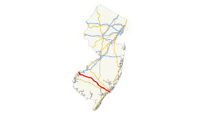
→U.S. Route 322 is a U.S. highway running from Cleveland, Ohio east to Atlantic City, New Jersey. The easternmost segment of the route in New Jersey runs 62.81 miles (101.08 km) from the Commodore Barry Bridge over the Delaware River in Logan Township, Glocuester County, where it continues into Chester, Pennsylvania, southeast to Atlantic Avenue and Pacific Avenue in Atlantic City, Atlantic County. The portion of the route between the Commodore Barry Bridge and Route 42 is mostly a two-lane undivided road that is concurrently signed with County Route 536, passing through Mullica Hill and Glassboro. From Williamstown, US 322 follows the Black Horse Pike, a four-lane road, southeast to Atlantic City. In Hamilton Township, Atlantic County, US 322 forms a concurrency with U.S. Route 40, continuing with that route all the way to Atlantic City. US 322 intersects several major roads including U.S. Route 130 and Interstate 295 in Logan Township, the New Jersey Turnpike in Woolwich Township, Route 55 in Harrison Township, Route 42 in Williamstown, Route 50 and U.S. Route 40 in Hamilton Township, the Garden State Parkway in Egg Harbor Township, and U.S. Route 9 in Pleasantville.
East of Williamstown, US 322 follows the Black Horse Pike, a turnpike between Camden and Atlantic City that was created in 1855. Pre-1927 Route 18S was designated along the portion of the current route east of McKee City in 1923, with the US 40 designation along this portion following in 1926. In 1927, Route 18S became Route 48 and Route 42 was designated along the road between Williamstown and McKee City. US 322 was extended to New Jersey in 1936, running from a ferry dock on the Delaware River in Bridgeport east to Williamstown, where it followed Route 42 and U.S. Route 40/Route 48 to Atlantic City. In 1938, Route 55 was legislated along US 40/US 322 in Atlantic City while in 1939, US 322 between the ferry dock and Route 44 (now US 130) became Route S44 and the route between there and Route 42 became Route 51. In 1953, the state highway designations were removed from US 322. After the Commodore Barry Bridge opened in 1974, the old approach to the ferry dock became Route 324. In 1960, a freeway was proposed for US 322 in Gloucester County, running from the site of the Commodore Barry Bridge to Williamstown. This $59.6 million proposal was canceled by the 1970s due to diversion of funds to mass transit. Subsequent proposals for freeways in 1983 and 1995 also failed. A bypass of Mullica Hill is currently under construction for US 322 in order to relieve traffic through that town.
Contents
Route description
Gloucester County
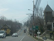 US 322 eastbound approaching split with southbound Route 45 in Mullica Hill
US 322 enters New Jersey from Chester, Pennsylvania on the Commodore Barry Bridge over the Delaware River.[2][3] Upon entering New Jersey, the highway runs concurrently with County Route 536 until Williamstown.[4] The road heads southeast into swampy areas of Logan Township as a five-lane road maintained by the Delaware River Port Authority, eventually becoming a six-lane divided highway as it passes over the access road to Route 324 and comes to the westbound toll plaza for the bridge.[2][3] A short distance later, US 322 has a cloverleaf interchange with U.S. Route 130 and continues south through the community of Bridgeport as it narrows into a two-lane undivided road known as Swedesboro-Bridgeport Road.[2] It continues through rural areas of farms and woods prior to an interchange with Interstate 295, at which point the road widens into a four-lane divided highway.[2][3] After I-295, US 322 makes a turn to the east and crosses into Woolwich Township, narrowing back into a two-lane undivided road with no name. Here, the route crosses County Route 551 prior to an interchange with the New Jersey Turnpike.[2]
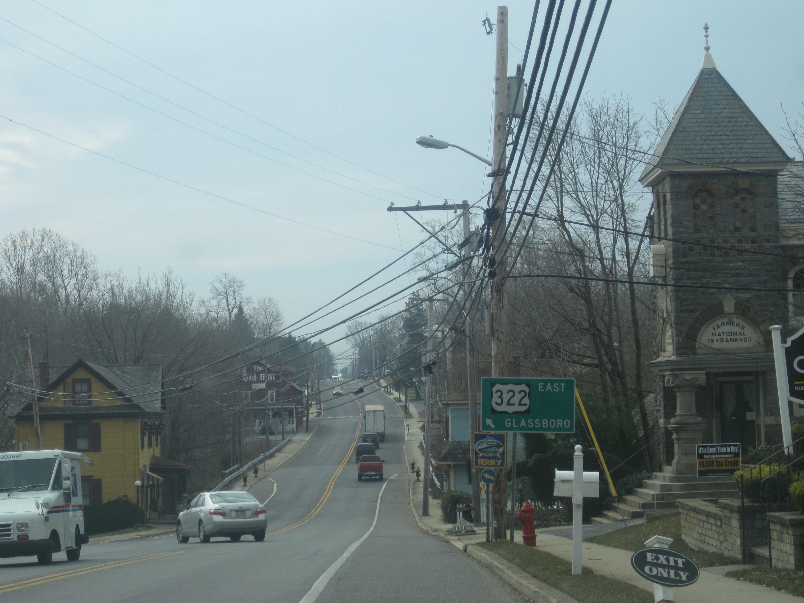
Past the New Jersey Turnpike, US 322 starts to curve southeast and crosses into Harrison Township, where it passes suburban neighborhoods as Bridgeport-Mullica Hill Road. It continues into Mullica Hill, where it intersects Route 45 and forms a concurrency with that route, running south through residential and commercial areas of the town as Main Street. Upon splitting from Route 45, US 322 continues east into a mix of woods, farms, and homes as Mullica Hill Road, passing through Richwood.[2][3] The route interchanges with Route 55, where it is briefly a four-lane road, before entering Glassboro.[2] In Glassboro, the route becomes Best Avenue, passing residential areas prior to bisecting the campus of Rowan University.[2][3] A short distance later, US 322 crosses County Route 553 before coming to Route 47.[2] Here, it turns south to form a concurrency with that route on three-lane Delsea Drive, passing more homes and businesses. US 322 splits from Route 47 by heading east on High Street, a two-lane road, and enters wooded areas with some development and farmland.[2][3]
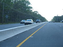
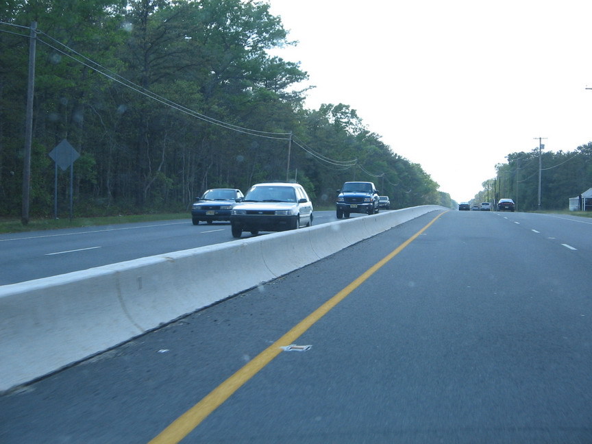
After exiting Glassboro for Monroe Township, US 322 continues east and crosses County Route 555 prior to reaching Williamstown, where the road passes residential and business development.[2][3] Here, US 322 turns north, while County Route 536 splits from the route by continuing southeast on Main Street. A short distance after the split, US 322 intersects Route 42 (Black Horse Pike) and turns southeast onto it. At this intersection, County Route 536 Spur continues to the north.[2] On the Black Horse Pike, a four-lane divided highway line with businesses, the route soon crosses County Route 536 before leaving the Williamstown area and becoming a four-lane undivided road. US 322 continues southeast through predominantly forested areas with occasional development, intersecting County Route 538.[2][3] In 2006, an average of 10,615 vehicles used the road annually in Gloucester County.[5]
Atlantic County
Entering Folsom in Atlantic County, US 322 passes a couple lakes and some wooded residences before coming to an interchange with Route 54, where the route has a median. Past this interchange, the road continues southeast through heavily forested areas to an intersection with the southern terminus of Route 73 (signed as County Route 561 Spur).[2][3] After this intersection, US 322 turns south and enters Hamilton Township, where it encounters County Route 559 at a traffic circle that has been modified to have US 322 run through it.[2] After passing more woods and a clearing for farms, the road widens into a four-lane divided highway and has an interchange with Route 50. A short while after, the route enters a residential and commercial area, passing by Atlantic Cape Community College before heading to the south of the Hamilton Mall. Here, US 322 intersects U.S. Route 40, which merges onto the Black Horse Pike.[2][3]
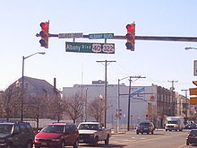
The two routes continue to the southeast through business areas, meeting County Route 575 and a ramp to the Atlantic City Expressway. CR 575 turns east to form a concurrency with US 40/US 322.[3][6] The road enters Egg Harbor Township, with CR 575 splitting from US 40/US 322 by turning to the south.[6] The route passes more wooded residential and commercial areas, as well as the Storybook Land amusement park, before intersecting County Route 563. US 40/US 322 forms a concurrency with that route and passes through a business district that includes the Shore Mall. CR 563 splits from the road by continuing southeast and the Black Horse Pike heads east interchange with the Garden State Parkway.[3][6] The only direct ramp present is between the Black Horse Pike westbound and the Garden State Parkway northbound, with all other movements are provided by CR 563.[3] Past here, US 40/US 322 continues east past more businesses, crossing County Route 651 before entering Pleasantville. In Pleasantville, the road crosses U.S. Route 9, where the name changes to Verona Avenue. Upon crossing County Route 585, the Black Horse Pike continues past residences as an undivided road, crossing back into Egg Harbor Township. The road passes more businesses, closely paralleling the Atlantic City Expressway before entering Atlantic City. Here, the name becomes Albany Avenue and it comes to a pair of ramps that provide access to and from the Black Horse Pike eastbound and the Atlantic City Expressway westbound.[3][6] US 40/US 322 enters marshland, crossing the Great Thorofare onto Great Island before passing over the Beach Thorofare. Past this bridge, the road passes between businesses to the west and the closed Bader Field airport and the abandoned Bernie Robbins Stadium to the east.[3] US 40/US 322 crosses the Inside Thorofare on a drawbridge and continues as a county maintained road to its end at Atlantic Avenue and Pacific Avenue, one block from the boardwalk.[3][6] In 2006, an average of 6,910 vehicles used the road daily in Atlantic County.[5]
History
Before 1953
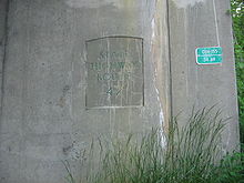 The former Route 42 designation of the Black Horse Pike shown on the Route 54 bridge in Folsom.
What is now U.S. Route 322 east of the Route 42 junction was established in 1855 as the Black Horse Pike, a turnpike that ran from Camden to Atlantic City via Blackwoodtown.[7] In 1923, the portion of present US 322 along the US 40 concurrency was designated as a part of pre-1927 Route 18S, a route that was built to connect Penns Grove to Atlantic City.[8] As a result of the creation of the U.S. Highway System in 1926, U.S. Route 40 was also signed along the alignment Route 18S.[9][10] A year later, in the 1927 New Jersey state highway renumbering, the current alignment of US 322 through New Jersey was designated as a part of Route 42 between Williamstown and McKee City, while Route 48 replaced the Route 18S designation along the portion between McKee City and Atlantic City.[11][12] The portion of US 40/US 322 in Atlantic City was legislated as Route 55 in 1938.[13]
 Route 51 (1939-1953)
In 1936, US 322 was extended into New Jersey, running from a ferry dock on the Delaware River in Bridgeport and continuing east from there through Mullica Hill and Glassboro to Williamstown, where it followed Route 42 to McKee City and U.S. Route 40/Route 48 to Atlantic City.[1][14] In 1939, the portion of US 322 between the ferry dock and Route 44 (now U.S. Route 130) was legislated as Route S44, a spur of Route 44, while the route between there and Route 42 in Williamstown was legislated as Route 51.[15] It is also this section between Bridgeport and Williamstown that was not in state highway jurisdiction at the time.[1]
1953 to present
In the 1953 New Jersey state highway renumbering, several state highways concurrent with US 322 were removed, including Route S44, Route 51, Route 42, Route 48, and Route 55.[16][17] The section of US 322 between former US 130 and Route 42 became state highway jurisdiction in 1955 after a state takeover.[1] This portion was also designated as part of County Route 536 with the creation of the 500-series county routes in 1952.[18] When the Commodore Barry Bridge opened in 1974 and replaced the ferry across the Delaware River, US 322 was moved to the new bridge approach and the former piece of the route to the ferry dock became Route 324.[1][19]
In the 1960s, plans started forming for a freeway along the US 322 corridor in Gloucester County.[20] A parkway had been planned in 1932 to run from Bridgeport east to the planned Camden-Atlantic City Parkway as part of a network of such roads proposed for the Philadelphia area; however, it was never built.[21] The freeway, which was planned to connect the then-proposed Commodore Barry Bridge to Route 42 in Williamstown, was projected to cost $59.6 million.[22][23] This freeway was proposed to be incorporated into the Interstate Highway System in 1970; however, this was denied. By the end of the 1970s, the US 322 freeway was canceled due to the desire to use highway funds for mass transit.[24] However, plans resurfaced for a freeway along the US 322 corridor in 1987, when Congressman William J. Hughes made a proposal for a road running from the New Jersey Turnpike to the Atlantic City Expressway, with access to the Route 55 freeway. This proposal was never built though.[25] In 1995, the New Jersey Turnpike Authority planned to build a toll road between the Commodore Barry Bridge and the Atlantic City Expressway, connecting with I-295, the New Jersey Turnpike, and Route 55. This proposal resulted from increased traffic volume on US 322 after the completion of Interstate 476 in Pennsylvania.[26] However, this proposal was soon canceled due to the possible destruction it would cause to residences, businesses, and the environment.[24] The Cardiff Circle along US 40/US 322 at CR 563 and CR 608 in Egg Harbor Township was eliminated in a $3.7 million project completed in 2002.[27]
Construction of a bypass around Mullica Hill began in December 2010 in order to relieve severe traffic congestion through the town. The route currently goes through the town's historical district, where it briefly joins state highway 45. The new alignment would remove the concurrency.[28] The road is estimated to cost $12 million,[29] and is described by a freeholder as being the "largest infrastructure project that has ever been undertaken in Gloucester County."[30] In addition to the proposed bypass, a portion of US 322 in the Mullica Hill area is being widened. Construction of the bypass portion initially awaited approval from the New Jersey Historical Sites Council to determine if it would impact the Mullica Hill Historic District.[30]
Major intersections
County Location Mile[2] Destinations Notes Commodore Barry Bridge over the Delaware River
County Route 536 ends here.Gloucester Logan Township 2.18  US 130 to Route 44 / I-295 – Penns Grove, Camden, Trenton
Interchange 3.95 I-295I-295 exit 11 Woolwich Township 6.99  CR 551 (Kings Highway)
7.81 NJ TurnpikeNJTP exit 2 Harrison Township 10.82 Route 45 north (Bridgeton Pike)West end of NJ 45 overlap 11.21 Route 45 south (Main Street)East end of NJ 45 overlap 15.22 Route 55NJ 55 exits 50A-B Glassboro 17.70  CR 553 (Main Street)
17.83  Route 47 north (Delsea Drive)
West end of NJ 47 overlap 18.19 Route 47 south (Delsea Drive)East end of NJ 47 overlap Monroe Township 22.98  CR 555 (North Tuckahoe Road)
24.21 

 CR 536 east (South Main Street) / CR 610 south (Clayton Road) / CR 654 (North Main Street)
East end of CR 536 overlap 24.47 

Route 42 north (Black Horse Pike) / CR 536 Spur north24.67 CR 536 (Poplar Street / New Brooklyn Road)30.13  CR 538 west (Coles Mill Road)
Atlantic Folsom 34.66  Route 54 – Hammonton, Trenton, Buena, Millville
Interchange 36.90
 Route 73 / CR 561 Spur north (Mays Landing Road)
Hamilton Township 41.37  CR 559 (Weymouth Road)
Modified traffic circle 46.03 Route 50 – Mays Landing, Egg Harbor CityInterchange 50.26
(51.77) US 40 west (Harding Highway)West end of US 40 overlap; mileposts signed for U.S. Route 40 (italicized) 50.46
(51.97)
 CR 575 north (Wrangleboro Road) to AC Exwy.
West end of CR 575 overlap Egg Harbor Township 52.38
(53.89) CR 575 south (English Creek Avenue)East end of CR 575 overlap 55.47
(56.98) CR 563 north (Tilton Road)
West end of CR 563 overlap 55.87
(57.38) CR 563 south (Tilton Road)East end of CR 563 overlap 55.95
(57.46) G.S. Pkwy. northGSP exit 36 Pleasantville 57.62
(59.13) US 957.99
(59.50) CR 585 (Main Street)
Atlantic City 60.48-60.66
(61.99-62.17) AC Exwy. west to G.S. Pkwy. – Camden, PhiladelphiaACE exit 2 61.18
(62.69)Atlantic City High School Interchange 62.81
(64.32)Atlantic Avenue/Pacific Avenue Eastern terminus of US 40/US 322 1.000 mi = 1.609 km; 1.000 km = 0.621 mi See also
 U.S. Roads portal
 New Jersey portal
References
- ^ a b c d e "US 322 Straight Line Diagram". Internet Archives WayBack Machine. New Jersey Department of Transportation. 2004. Archived from the original on 2004-07-24. http://web.archive.org/web/20040724135549/http://www.state.nj.us/transportation/refdata/sldiag/00000322__-.pdf. Retrieved 2007-06-14.
- ^ a b c d e f g h i j k l m n o p q r "US 322 Straight Line Diagram" (PDF). New Jersey Department of Transportation. http://www.state.nj.us/transportation/refdata/sldiag/00000322__-.pdf. Retrieved 2007-06-13.
- ^ a b c d e f g h i j k l m n o p Google, Inc. Google Maps – overview of U.S. Route 322 in New Jersey (Map). Cartography by Google, Inc. http://maps.google.com/maps?f=d&source=s_d&saddr=Commodore+Barry+Bridge&daddr=39.7318,-75.20044+to:39.68844,-74.99368+to:39.61528,-74.91469+to:39.49699,-74.7491+to:39.40046,-74.56088+to:39.35,+-74.4535&geocode=FVK6XwIdnuuB-yEiLIL3zZpUfQ%3BFVhCXgIdSIiE-ynVUP_dB9nGiTETEYdgvQvwpw%3BFfiYXQId8K-H-ynpKh_9GNXGiTGpidHI_jJPSw%3BFTB7XAIdfuSI-ylZSXVCptXAiTFjvTVxsry4Yw%3BFR6tWgIdVGuL-ymdVKSZ9trAiTHKwqzqmdI90A%3BFQw0WQIdkEqO-ymrPeSHTujAiTHWcmATn2NciQ%3BFfBuWAIdBO6P-w&hl=en&mra=dpe&mrcr=0&mrsp=5&sz=9&via=1,2,3,4,5&sll=39.61744,-74.9124&sspn=0.964763,2.705383&ie=UTF8&t=h&z=9. Retrieved 2009-10-13.
- ^ "County Route 536 Straight Line Diagram" (PDF). New Jersey Department of Transportation. http://www.state.nj.us/transportation/refdata/sldiag/00000536__-.pdf. Retrieved 2007-06-13.
- ^ a b "2006 Annual Traffic Summary" (TXT). New Jersey Department of Transportation. 2007-03-26. http://www.state.nj.us/transportation/refdata/roadway/TextFiles/2007/2006SUMR.zip. Retrieved 2007-06-13.
- ^ a b c d e "US 40 Straight Line Diagram" (PDF). New Jersey Department of Transportation. http://www.state.nj.us/transportation/refdata/sldiag/00000040__-.pdf. Retrieved 2009-10-14.
- ^ "Answer Guy: How did the White Horse and Black Horse Pikes get their names?". The Press of Atlantic City. August 31, 2008.
- ^ Williams, Jimmy and Sharon. "NJ 1920s Route 18-S". 1920s New Jersey Highways. http://www.jimmyandsharonwilliams.com/njroads/1920s/route18s.htm. Retrieved 2009-03-04.
- ^ Bureau of Public Roads (1926). United States System of Highways (Map). http://en.wikipedia.org/wiki/Image:1926us.jpg. Retrieved 2009-04-27.
- ^ Tydol Trails. 1927 Tydol Trails Map - South (Map).
- ^ State of New Jersey, Laws of 1927, Chapter 319.
- ^ 1920s New Jersey Highways. 1927 New Jersey Road Map (Map).
- ^ State of New Jersey, Laws of 1938, Chapter 283.
- ^ Mid-West Map Co. (1941). Map of Pennsylvania and New Jersey (Map). Cartography by H.M. Gousha. http://www.mapsofpa.com/roadcart/1941_1467m.jpg. Retrieved 2009-03-29.
- ^ State of New Jersey, Laws of 1939, compiled.
- ^ 1953 renumbering, New Jersey Department of Highways, http://en.wikisource.org/wiki/1953_New_Jersey_state_highway_renumbering, retrieved July 31, 2009
- ^ "New Road Signs Ready in New Jersey". The New York Times. December 16, 1952. http://img123.imageshack.us/img123/6933/19521216newroadsignsreaiu6.jpg. Retrieved 2009-07-20.
- ^ Chevron Oil Company (1969). Map of New Jersey (Map). Cartography by H.M. Gousha.
- ^ "Route 324 straight line diagram". New Jersey Department of Transportation. http://www.state.nj.us/transportation/refdata/sldiag/00000324__-.pdf. Retrieved 2007-03-19.
- ^ New Jersey Builds Better Highways. New Jersey State Highway Department. 1961.
- ^ Regional Plan of the Philadelphia Tri-State District. Regional Planning Federation. 1932.
- ^ New Jersey Highway Facts. New Jersey Department of Transportation. 1967.
- ^ 1985 Regional Transportation Plan. Delaware Valley Regional Planning Commission. 1969.
- ^ a b Anderson, Steve. "US 322 Freeway (New Jersey, unbuilt)". Eastern Roads. http://www.phillyroads.com/roads/US-322_NJ/. Retrieved 2009-10-14.
- ^ Sardella, Carlos M. (August 16, 1987). "Route 55 Extension Plan Due". The New York Times.
- ^ "Proposed Atlantic City Expressway-New Jersey Turnpike Connector – Alternative Route Development Study Phase I – Executive Summary". Parsons Brinckerhoff. February 1995. http://www.co.gloucester.nj.us/Pdf/homepage/NJTurnpikeAuthority.pdf. Retrieved 2009-10-14.
- ^ "Temporary detour of traffic at the Cardiff Circle to begin Friday evening, May 3". New Jersey Department of Transportation. 2002-05-01. http://www.state.nj.us/transportation/about/press/2002/050102.shtm. Retrieved 2009-10-21.
- ^ John Barna (2010-12-29). "Gloucester County breaks ground on Route 322 bypass". Gloucester County Times. http://www.nj.com/gloucester-county/index.ssf/2010/12/gloucester_county_breaks_groun.html. Retrieved 2011-11-05.
- ^ Hefler, Jan (October 21, 2007). "Can’t get around fight over road to the Shore". The Philadelphia Inquirer. http://www.322bypass.com/pdf/PhilaInquirer102107article. Retrieved 2009-10-14.
- ^ a b McCarthy, Pete (October 9, 2009). "Project needs group’s approval". Gloucester County Times. http://www.322bypass.com/pdf/gct100909article. Retrieved 2009-10-14.
External links
Road transportation infrastructure of the metro Philadelphia area Interstates U.S. Routes Pennsylvania Routes New Jersey Routes Delaware Routes Named roads/streets Benjamin Franklin Parkway · Broad Street · City Avenue · Front Street · Girard Avenue · Market Street · Roosevelt Boulevard · South Street · Chestnut Street · Walnut Street
Pennsylvania Turnpike · New Jersey Turnpike · Delaware Turnpike · Atlantic City Expressway · Schuylkill Expressway · Delaware Expressway · Blue Route · Vine St Expressway · North South Freeway · Lancaster Avenue · Bethlehem Pike · Baltimore Pike · Black Horse PikeBridges Delaware Memorial Bridge · Commodore Barry Bridge · Walt Whitman Bridge · Ben Franklin Bridge · Betsy Ross Bridge · Tacony–Palmyra Bridge · Burlington–Bristol Bridge · Delaware River – Turnpike Toll Bridge U.S. Route 322Previous state:
PennsylvaniaNew Jersey Next state:
TerminusCategories:- U.S. Highways in New Jersey
- U.S. Route 322
- Transportation in Atlantic County, New Jersey
- Transportation in Gloucester County, New Jersey


Wikimedia Foundation. 2010.