- U.S. Route 13 in Pennsylvania
-
This article is about the section of U.S. Route 13 in Pennsylvania. For the entire length of the highway, see U.S. Route 13."Pennsylvania Route 13" redirects here. For the former highway, see Pennsylvania Route 13 (1920s)."PA 13" redirects here. PA 13 may also refer to Pennsylvania's 13th congressional district.
U.S. Route 13

Route information Maintained by PennDOT Major junctions South end:  US 13 at Delaware border in Marcus Hook
 US 322 in Chester

 I-76 / US 30 in Philadelphia
 PA 611 in Philadelphia
 US 1 in Philadelphia
 PA 63 in Bensalem Township
 I-276 / Penna. Tpk. in Bristol Township
North end: US 1 in Falls TownshipHighway system United States Numbered Highways
List • Bannered • Divided • ReplacedRoads in Pennsylvania
Interstate • US • State • Legislative←  PA 12
PA 12PA 13  →
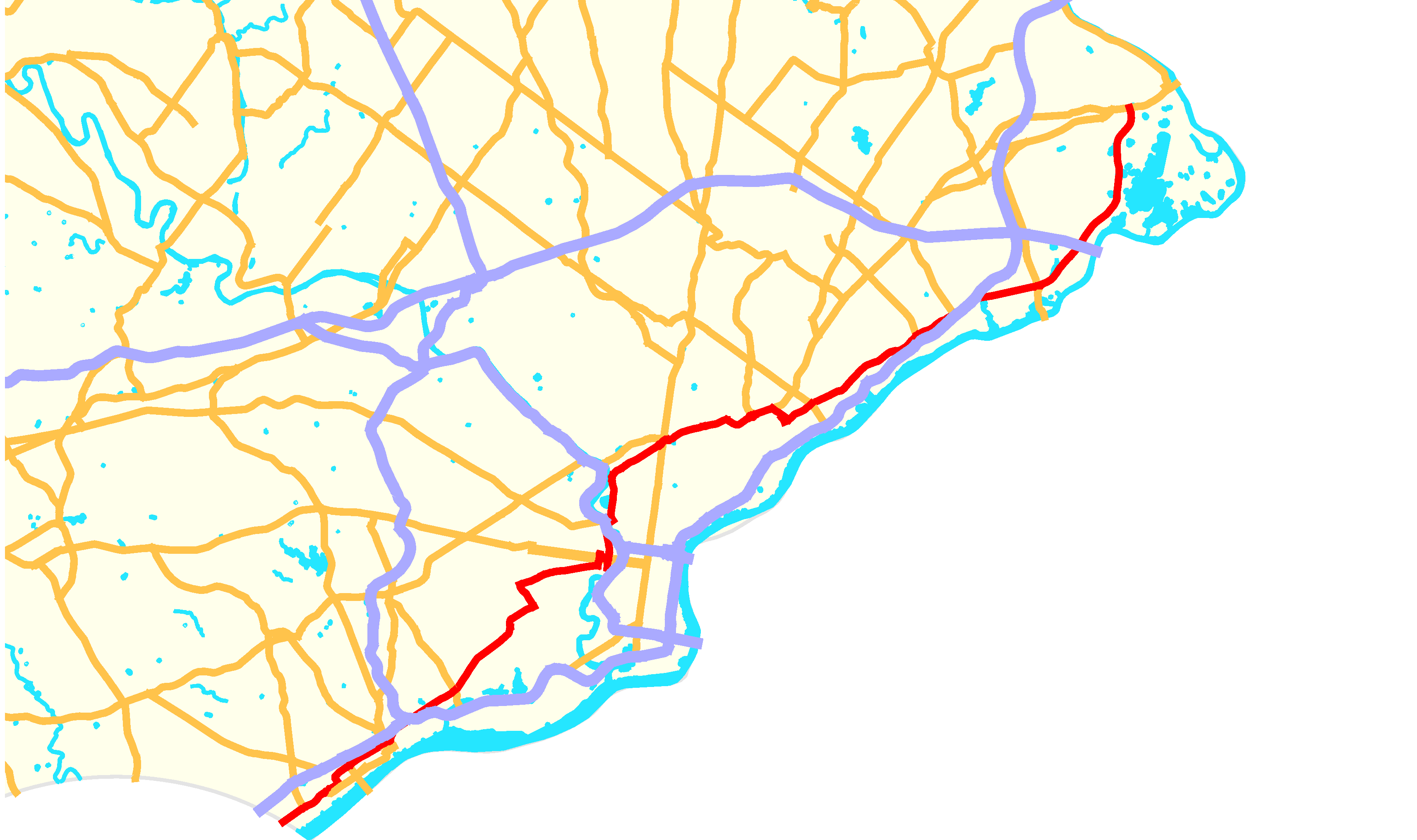
→U.S. Route 13 passes through the Philadelphia metropolitan area in the U.S. state of Pennsylvania. The route enters the state from Delaware in Marcus Hook, Delaware County. It continues in a northeasterly direction through Delaware County, passes through Philadelphia, and continues into Bucks County, where it ends at U.S. 1 in Falls Township, west of the borough of Morrisville.Throughout most of its route in Pennsylvania, U.S. Route 13 runs within a close distance of Interstate 95.
Contents
Route description
Delaware County
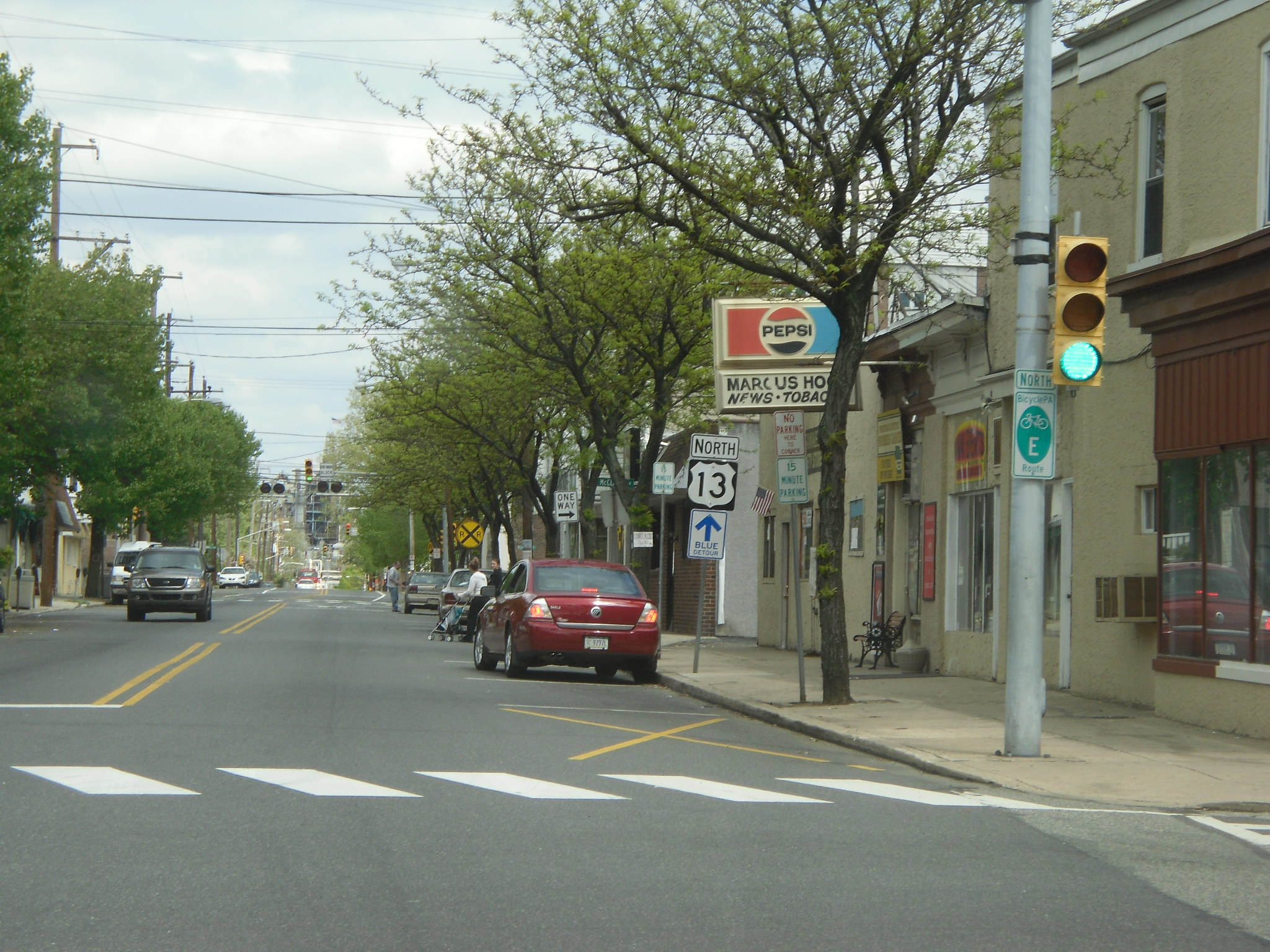
 US 13 northbound in Marcus Hook
U.S. Route 13 crosses into Pennsylvania from Delaware in the borough of Marcus Hook, where the road is known as Post Road. It passes through a huge Sunoco oil refinery and then the town itself, where it meets the southern terminus of Pennsylvania Route 452. The road then enters the borough of Trainer, where it passes by a ConocoPhillips refinery. It is also where U.S. Route 13 intersects the western terminus of Pennsylvania Route 291, which runs a short distance from the Delaware River in Delaware County destined for Philadelphia International Airport.
U.S. Route 13 then enters the city of Chester, where the name changes to Fourth Street. It follows Fourth Street east for a short distance before turning north on Highland Avenue and then east on Ninth Street. Ninth Street carries U.S. Route 13 through the majority of Chester. It features an interchange with the U.S. Route 322 approach to the Commodore Barry Bridge and then continues into Downtown Chester, where it intersects the southern terminus of Pennsylvania Route 352 and Pennsylvania Route 320 (Avenue of the States). U.S. Route 13 then continues in an easterly direction and exits Chester on Morton Avenue.
It then leaves Chester and the road name changes to Chester Pike. US 13 forms the northern border of the borough of Eddystone and then enters Ridley Township. U.S. Route 13 passes under I-95 and continues into the borough of Ridley Park. It intersects Stewart Avenue, which heads south to provide access to I-95 and PA 291. U.S. Route 13 continues into Prospect Park, where it crosses Pennsylvania Route 420. It heads eastward, passing through the boroughs of Norwood, Glenolden, Folcroft, and Sharon Hill. It then enters the borough of Collingdale, where it merges onto Macdade Boulevard.
Macdade Boulevard carries U.S. Route 13 through the borough of Darby and into the borough of Yeadon. In Yeadon, U.S. Route 13 turns north onto Church Lane. It follows Church Lane to Baltimore Aveue, where it turns east onto Baltimore Avenue and continues into the city of Philadelphia.
Philadelphia
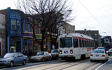 SEPTA's Route 34 streetcar line runs through the 4500 block of Baltimore Avenue (US 13) in West Philadelphia
U.S. Route 13 enters the West Philadelphia section of the city on Baltimore Avenue. Along the way, SEPTA Route 34 of the Subway–Surface Trolley Lines runs on US 13 from the Angora Loop at 61st Street to the 40th Street Portal. The route continues east through West Philadelphia towards University City. It then turns north from Baltimore Avenue on 38th Street near the University of Pennsylvania campus. U.S. Route 13 crosses Pennsylvania Route 3, which intersects US 13 along a one-way pair, with the westbound routing following US 13 southbound between Market Street and Walnut Street and the eastbound routing crossing US 13 on Chestnut Street.
U.S. Route 13 turns east onto two-way Powelton Avenue. Powelton Avenue carries U.S. Route 13 across Lancaster Avenue into the Mantua section of the city. Here, U.S. Route 13 splits onto 33rd Street northbound and 34th Street southbound. It follows this one-way pair up to the crossing of the Northeast Corridor, where it heads two-way on 34th Street. 34th Street runs between the Philadelphia Zoo to the west and the Schuylkill Expressway (Interstate 76) to the east.
U.S. Route 13 then meets Girard Avenue, which at this point carries U.S. Route 30. It turns east onto Girard Avenue, where U.S. Route 30 turns east onto the Schuylkill Expressway. U.S. Route 13 crosses the Schuylkill Expressway and then the Schuylkill River.
Across the Schuylkill River, U.S. Route 13 turns north on 33rd Street. It forms the eastern boundary of Fairmount Park and then merges onto Ridge Avenue. It then heads northeast onto Hunting Park Avenue into the North Philadelphia section of the city. Hunting Park Avenue splits to the east and U.S. Route 13 becomes Roosevelt Boulevard, crossing Broad Street (Pennsylvania Route 611). It then merges onto [[U.S. Route 1 in Pennsylvania|U.S. 1], continuing along Roosevelt Boulevard.

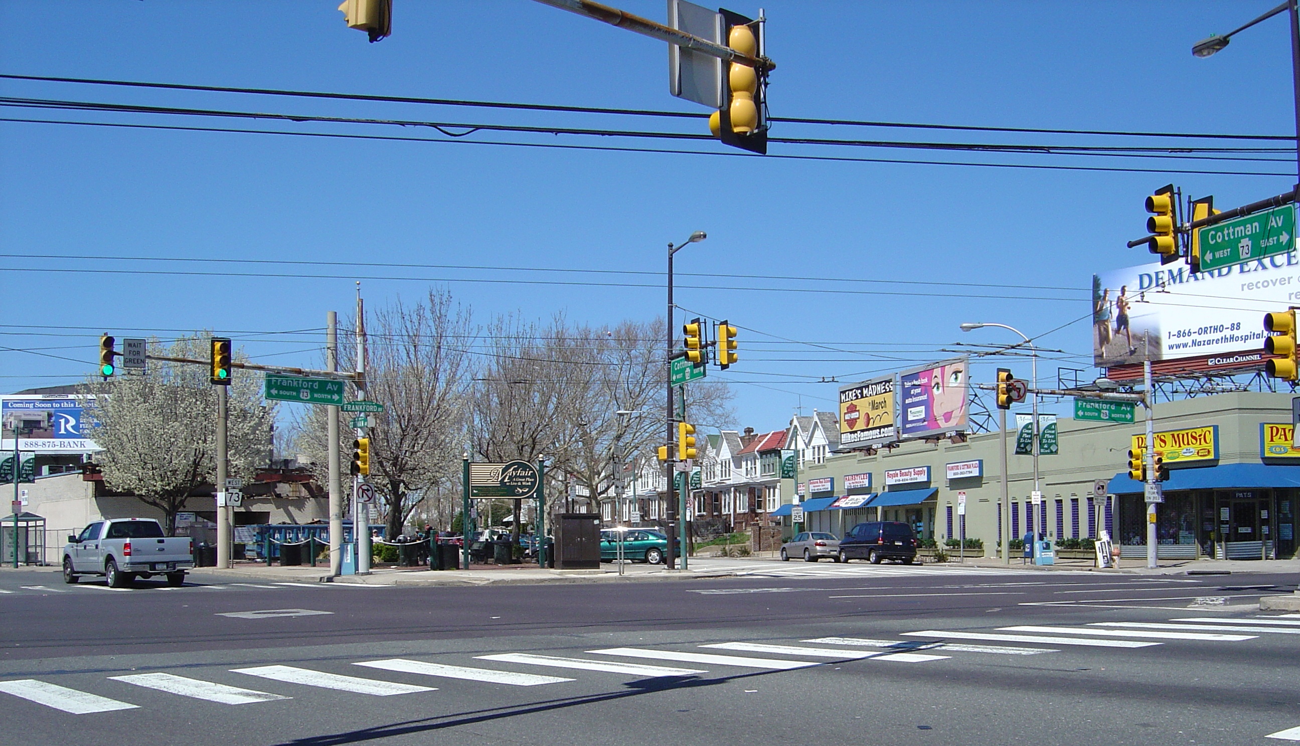
U.S. Route 13, along with US 1, continues east on the wide, multi-lane Roosevelt Boulevard into Northeast Philadelphia. It passes underneath the Oxford Circle, a traffic circle where Oxford Avenue, Cheltenham Avenue, and Castor Avenue meet. This circle marks the southern terminus of Pennsylvania Route 232, which heads north on Oxford Avenue. U.S. Route 13 splits from the Roosevelt Boulevard by heading southeast on the one-way pair of Robbins Street northbound and Levick Street southbound. It follows this one-way pair to Frankford Avenue, which it turns onto, heading northeast. Robbins and Levick Streets continue southeast toward the Tacony-Palmyra Bridge.
Frankford Avenue carries U.S. Route 13 northeastward. It intersects Cottman Avenue (Pennsylvania Route 73) and then crosses the Pennypack Creek. Frankford Avenue then intersects Academy Road before crossing the Poquessing Creek into Bucks County.
Bucks County
U.S. Route 13 crosses into Bensalem Township in Bucks County, where the name becomes Bristol Pike. It features an interchange with Pennsylvania Route 63 (Woodhaven Road) a short distance north of I-95. U.S. Route 13 then intersects the southern terminus of Pennsylvania Route 513 before featuring another interchange with Pennsylvania Route 132 (Street Road). It then crosses under I-95 and then over the Neshaminy Creek into Bristol Township.
In Bristol Township, U.S. Route 13 heads in an easterly direction, following the Northeast Corridor rail line to the north. It then crosses Pennsylvania Route 413 a short distance north of the Burlington-Bristol Bridge. U.S. Route 13 then skirts the northern edge of the borough of Bristol before featuring an interchange with the Pennsylvania Turnpike (Interstate 276), the easternmost interchange on the mainline turnpike before the Delaware River-Turnpike Toll Bridge.
U.S. Route 13 continues north to the borough of Tullytown. It then enters Falls Township, where it transforms into a limited-access highway, running along the eastern border of the planned suburb of Levittown. It features diamond interchanges with the Mill Creek Parkway and Penn Valley Road. It then features a cloverleaf interchange with Tyburn Road. U.S. Route 13 then intersects Lower Morrisville Road before ending at an interchange with U.S. Route 1. The expressway ends here, and the road continues north as an unnumbered surface road called Pine Grove Road, which heads into Lower Makefield Township.
History
Prior to 1928, U.S. Route 13 was Pennsylvania Route 91 between the Delaware border and Philadelphia and Pennsylvania Route 32 from Philadelphia to Morrisville.[1] In 1954, construction began on the limited-access portion of US 13 in Bucks County with the section from U.S. Route 1 to Tyburn Road opening in 1955 and the section from Tyburn Road to Tullytown opening in 1956. U.S. Route 13 was moved to this expressway from its former alignment which followed Bristol Pike between Tullytown and Morrisville.[2]
At the time of its completion, this expressway was planned to be a part of Interstate 95, with the highway leaving its current alignment at Exit 40 (Pennsylvania Route 413) and following US 13 up to US 1, where it would head north into Trenton by way of the Trenton-Morrisville Toll Bridge. However, New Jersey officials opposed this plan, and I-95 was routed to cross the Delaware River on the Scudders Falls Bridge. In 1969, another plan was created to build a US 13 expressway that would provide a direct connection between I-95 and the Pennsylvania Turnpike (Interstate 276). It would have run from Exit 40 of I-95, intersect the PA Turnpike, and head to the southern end of the completed US 13 expressway in Tullytown. It was eventually cancelled due to feared environmental impacts on Silver Lake Park.[3]
Major intersections
County Location Mile Destinations Notes Delaware Marcus Hook 0.00 Delaware state line  PA 452 north (Market Street)
Trainer  PA 291 east (Price Street)
Chester  To I-95 / Highland Avenue, 9th Street
Former US 13 Bypass south To I-95 / US 322 west / Engle Street US 322 east (Commodore Barry Bridge) / Flower Street – BridgeportInterchange To I-95 south / Kerlin StreetFormer US 13 Bypass north  PA 352 north (Avenue of the States)
 PA 320 (Madison Street, Upland Street)
Ridley Park To I-95 / Stewart AvenueProspect Park  PA 420 (Lincoln Avenue)
Collingdale MacDade Boulevard Former US 13 Bypass south Darby Main Street Former US 13 Bypass north East Lansdowne Baltimore Avenue Former US 1 south Philadelphia Philadelphia  PA 3 west (Walnut Street)
South end of PA 3 west overlap PA 3 east (Chestnut Street)Market Street North end of PA 3 west overlap US 30 west (Girard Avenue) to I-76 (Schuylkill Expressway)South end of US 30 overlap US 30 east (Girard Avenue)North end of US 30 overlap Girard Avenue Bridge over the Schuylkill River Kelly Drive Interchange; southbound exit and northbound entrance; former US 13 Bypass south PA 611 (Broad Street) US 1 south (Roosevelt Expressway)Interchange; south end of US 1 overlap; southbound exit and northbound entrance  PA 232 (Oxford Avenue) / Cheltenham Avenue
Interchange (Oxford Circle) US 1 north (Roosevelt Boulevard)North end of US 1 overlap  PA 73 (Cottman Avenue) To I-95 / Academy Road
Bucks Bensalem Township PA 63 (Woodhaven Road) to I-95 – Trenton, Central PhiladelphiaInterchange  PA 513 north (Hulmeville Road)
 PA 132 (Street Road) – Trenton, Central Philadelphia
Interchange Bristol  PA 413 to I-95 – Penndel, Bristol, Burlington Bristol Bridge
Bristol Township I-276 / Penna. Tpk.Interchange Tullytown Fallsington Avenue - Tullytown Falls Township South end of freeway Mill Creek Road Penn Valley Road Tyburn Road Lower Morrisville Road US 1 – Philadelphia, Morrisville, TrentonNorthbound exit and southbound entrance Pine Grove Road - Yardley Continuation beyond US 1 References
- ^ The US Highway System and Numbering – The Pennsylvania State Route Numbering System – Central PA/MD Roads URL accessed 3 July 2008
- ^ Pennsylvania Highways: US 13 URL accessed 3 July 2008
- ^ US 13 Expressway (Pennsylvania) URL accessed 3 July 2008
Road transportation infrastructure of the metro Philadelphia area Interstates U.S. Routes Pennsylvania Routes New Jersey Routes Delaware Routes Named roads/streets Benjamin Franklin Parkway · Broad Street · City Avenue · Front Street · Girard Avenue · Market Street · Roosevelt Boulevard · South Street · Chestnut Street · Walnut Street
Pennsylvania Turnpike · New Jersey Turnpike · Delaware Turnpike · Atlantic City Expressway · Schuylkill Expressway · Delaware Expressway · Blue Route · Vine St Expressway · North South Freeway · Lancaster Avenue · Bethlehem Pike · Baltimore Pike · Black Horse PikeBridges Delaware Memorial Bridge · Commodore Barry Bridge · Walt Whitman Bridge · Ben Franklin Bridge · Betsy Ross Bridge · Tacony–Palmyra Bridge · Burlington–Bristol Bridge · Delaware River – Turnpike Toll Bridge U.S. Route 13Previous state:
DelawarePennsylvania Next state:
TerminusCategories:- U.S. Highways in Pennsylvania
- U.S. Route 13


Wikimedia Foundation. 2010.