- Pennsylvania Route 132
-
PA Route 132
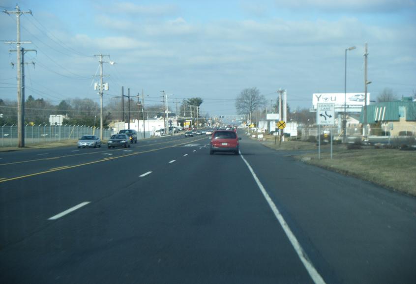
Street Road
Armed Forces and Veterans Memorial Highway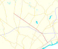
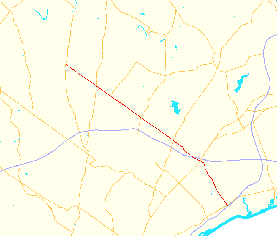
Map of northern suburbs of Philadelphia with PA 132 highlighted in redRoute information Maintained by PennDOT Length: 15.1 mi[2] (24 km) Existed: by 1930[1] – present Major junctions West end:  PA 611 in Warrington Township
 US 1 in Bensalem Township

 I-276 / Penna. Tpk. in Bensalem Township
 US 13 in Bensalem Township
East end:  I-95 in Bensalem
Location Counties: Bucks Highway system Roads in Pennsylvania
Interstate • US • State • Legislative←  PA 131
PA 133  →
→Pennsylvania Route 132 (PA 132) is a state highway in southeast Pennsylvania. It runs northwest to southeast through Bucks County in suburban Philadelphia from PA 611 in Warrington Township to Interstate 95 (I-95) in Bensalem Township. It is a commercial route lined with shopping centers throughout much of its 15-mile (24 km) length. It is named Street Road and is five lanes wide for much of its length. It was also designated as the Armed Forces and Veterans Memorial Highway in 2005. From west to east, it crosses PA 263 and PA 332 in Warminster Township, PA 232 in Upper Southampton Township, PA 532 in Lower Southampton Township, and U.S. Route 1 (US 1), PA 513, and US 13 in Bensalem Township. Street Road was included in William Penn's survey plans and completed by 1737. The road was paved by 1911 and received the PA 132 designation by 1930. The road was widened into a divided highway and extended to I-95 by 1970. An E-ZPass-only interchange with the Pennsylvania Turnpike (I-276) opened in 2010.
Contents
Route description

PA 132 begins at an intersection with PA 611 (Easton Road) in Warrington Township, heading to the southeast on West Street Road, a four-lane road that alternates between a divided highway and an undivided five-lane road including a center left-turn lane. West of PA 611, Street Road continues as an unnumbered road to Lower State Road. It heads through commercial areas before crossing the Little Neshaminy Creek and entering residential areas. At the Valley Road intersection, the route crosses into Warminster Township and continues through suburban development. PA 132 enters commercial areas as it comes to an intersection with PA 263 (York Road). After crossing the New Hope and Ivyland Railroad at-grade about 300 feet (91 m) north of that railroad meeting SEPTA's Warminster Line, the route passes through industrial areas before intersecting PA 332 (Jacksonville Road).[2][3]
Past the PA 332 intersection, the road continues through a mix of homes and businesses as East Street Road. Upon crossing Davisville Road, PA 132 enters Upper Southampton Township and passes more businesses. The road crosses PA 232 (Second Street Pike) in the community of Southampton before crossing a bridge over SEPTA's abandoned Fox Chase/Newtown Line. After passing through wooded residential areas, the road crosses into Lower Southampton Township at the Stump Road intersection and passes under Norfolk Southern's Morrisville Line.[2][3]
Street Road continues past a mix of residential and commercial development as it comes to an intersection with PA 532 (Bustleton Pike) in the community of Feasterville. After crossing PA 532, the road heads past several businesses before turning south-southeast into woodland. PA 132 turns southeast again and intersects Philmont Avenue prior to entering Bensalem Township. Upon entering Bensalem, the route passes over SEPTA's West Trenton Line on a bridge as it enters commercial areas again. After a bridge over CSX's Trenton Subdivision, PA 132 passes under the Pennsylvania Turnpike (I-276) immediately before an intersection with Old Lincoln Highway, becoming a divided highway.[2][3]
A short distance later, the road reaches a partial cloverleaf interchange with US 1 before turning south and coming to an E-ZPass-only ramp that provides access to and from the eastbound Pennsylvania Turnpike. PA 132 continues south-southeast past more businesses, becoming an undivided road again and passing the entrance to the Philadelphia Park Racetrack and Parx Casino. The road passes more development as it reaches the PA 513 (Hulmeville Road) intersection. Farther southeast, PA 132 reaches an interchange with US 13 before ending at the I-95 interchange. Past I-95, Street Road continues as an unnumbered road to State Road.[2][3]
History
Street Road was originally surveyed in the late 17th century, with the road being included in the original survey plans of William Penn for the Province of Pennsylvania. The entire length of the road was completed by 1737.[4] Street Road became a paved road by 1911; at the time, the route was not defined as a legislative route.[5] By 1930, PA 132 was designated onto Street Road, running from US 611 (now PA 611) in Warrington Township southeast to US 13 in Bensalem Township.[1] The entire length of PA 132 was widened into a divided highway by 1970. As a result of this improvement, a portion of the road was relocated east of Feasterville, with the former alignment becoming Old Street Road. Also by this time, the route was extended southeast to an interchange with I-95.[6] In 2005, all of PA 132 was designated the Armed Forces and Veterans Memorial Highway.[7] On November 22, 2010, an E-ZPass only ramp with access to and from the eastbound Pennsylvania Turnpike in Bensalem Township opened, intended to provide improved access to the Parx Casino and reduce congestion at the Pennsylvania Turnpike interchange with US 1.[8]
Major intersections
The entire route is in Bucks County.
Location Mile[2] Destinations Notes Warrington Township 0.0 PA 611 (Easton Road)Warminster Township 2.6  PA 263 (York Road)
3.8  PA 332 (Jacksonville Road)
Upper Southampton Township 6.3  PA 232 (Second Street Pike)
Lower Southampton Township 9.0  PA 532 (Bustleton Pike)
Bensalem Township 11.4 US 1 – Philadelphia, MorrisvilleInterchange 11.7 I-276 / Penna. Tpk. east – New JerseyExit 352 (I-276), E-ZPass only 14.1  PA 513 (Hulmeville Road)
15.0 US 13 (Bristol Pike)Interchange 15.1 I-95Exit 37 (I-95) 1.000 mi = 1.609 km; 1.000 km = 0.621 mi References
- ^ a b Pennsylvania Department of Highways (1930). Tourist Map of Pennsylvania (Map). ftp://ftp.dot.state.pa.us/public/pdf/BPR_pdf_files/Maps/Statewide/Historic_OTMs/1930fr.pdf. Retrieved January 27, 2011.
- ^ a b c d e f Google, Inc. Google Maps – overview of Pennsylvania Route 132 (Map). Cartography by Google, Inc. http://maps.google.com/maps?f=d&source=s_d&saddr=PA+132+and+PA+611&daddr=40.1523583,-75.0051766+to:822+east+street+road+bensalem+pa&hl=en&geocode=FUTaZQIdAXmF-ykD9C7hTq_GiTFP36E0kPCWPQ%3BFSatZAIdCIOH-ylxQcalca3GiTEJmKwzLd7ZCg%3BFUCgYwId7ZWI-yk_JpmS5EzBiTFRCE0Xb5AQ7A&mra=ls&sll=40.083826,-74.932787&sspn=0.003743,0.010568&ie=UTF8&t=h&z=11&via=1. Retrieved November 24, 2010.
- ^ a b c d ADC Map (2006). Bucks County, Pennsylvania (Map). 1"=2000' (19th ed.). ISBN 0-87530-774-4.
- ^ "History of Bucks County, Pennsylvania". A. Warner & Co.. 1887. p. 334. http://books.google.com/books?id=vx8MAAAAYAAJ&pg=PA334&dq=%22street+road%22+history+bucks+county&hl=en&ei=3kR0TemrOoTEgQeyzr1B&sa=X&oi=book_result&ct=result&resnum=2&ved=0CDwQ6AEwAQ#v=onepage&q=%22street%20road%22%20history%20bucks%20county&f=false. Retrieved March 7, 2011.
- ^ Pennsylvania Department of Highways (1911). Map of Pennsylvania Showing State Highways (Map). ftp://ftp.dot.state.pa.us/public/pdf/BPR_pdf_files/Maps/Statewide/Historic_OTMs/1911.pdf. Retrieved January 27, 2011.
- ^ Pennsylvania Department of Highways (1970). Official Map of Pennsylvania (Map). ftp://ftp.dot.state.pa.us/public/pdf/BPR_pdf_files/Maps/Statewide/Historic_OTMs/1970fr.pdf. Retrieved March 7, 2011.
- ^ SENATE BILL No. 599, General Assembly of Pennsylvania, 2005, http://www.legis.state.pa.us/CFDOCS/Legis/PN/Public/btCheck.cfm?txtType=HTM&sessYr=2005&sessInd=0&billBody=S&billTyp=B&billNbr=0599&pn=1991, retrieved August 3, 2010
- ^ Mattar, George (November 23, 2010). "Turnpike E-ZPass exit opens at Street Road". The Intelligencer (Doylestown, PA).
Road transportation infrastructure of the metro Philadelphia area Interstates U.S. Routes Pennsylvania Routes New Jersey Routes Delaware Routes Named roads/streets Benjamin Franklin Parkway · Broad Street · City Avenue · Front Street · Girard Avenue · Market Street · Roosevelt Boulevard · South Street · Chestnut Street · Walnut Street
Pennsylvania Turnpike · New Jersey Turnpike · Delaware Turnpike · Atlantic City Expressway · Schuylkill Expressway · Delaware Expressway · Blue Route · Vine St Expressway · North South Freeway · Lancaster Avenue · Bethlehem Pike · Baltimore Pike · Black Horse PikeBridges Delaware Memorial Bridge · Commodore Barry Bridge · Walt Whitman Bridge · Ben Franklin Bridge · Betsy Ross Bridge · Tacony–Palmyra Bridge · Burlington–Bristol Bridge · Delaware River – Turnpike Toll BridgeCategories:- State highways in Pennsylvania
- Transportation in Bucks County, Pennsylvania

Wikimedia Foundation. 2010.