- Pennsylvania Route 23
-
"PA 23" redirects here. PA 23 may also refer to Pennsylvania's 23rd congressional district or the Piper Aztec.
PA Route 23
Route information Maintained by PennDOT Length: 81.04 mi[1] (130.42 km) Existed: 1928 – present Major junctions West end:  PA 441 in Marietta
 US 222 in Lancaster
 US 30 east of Lancaster
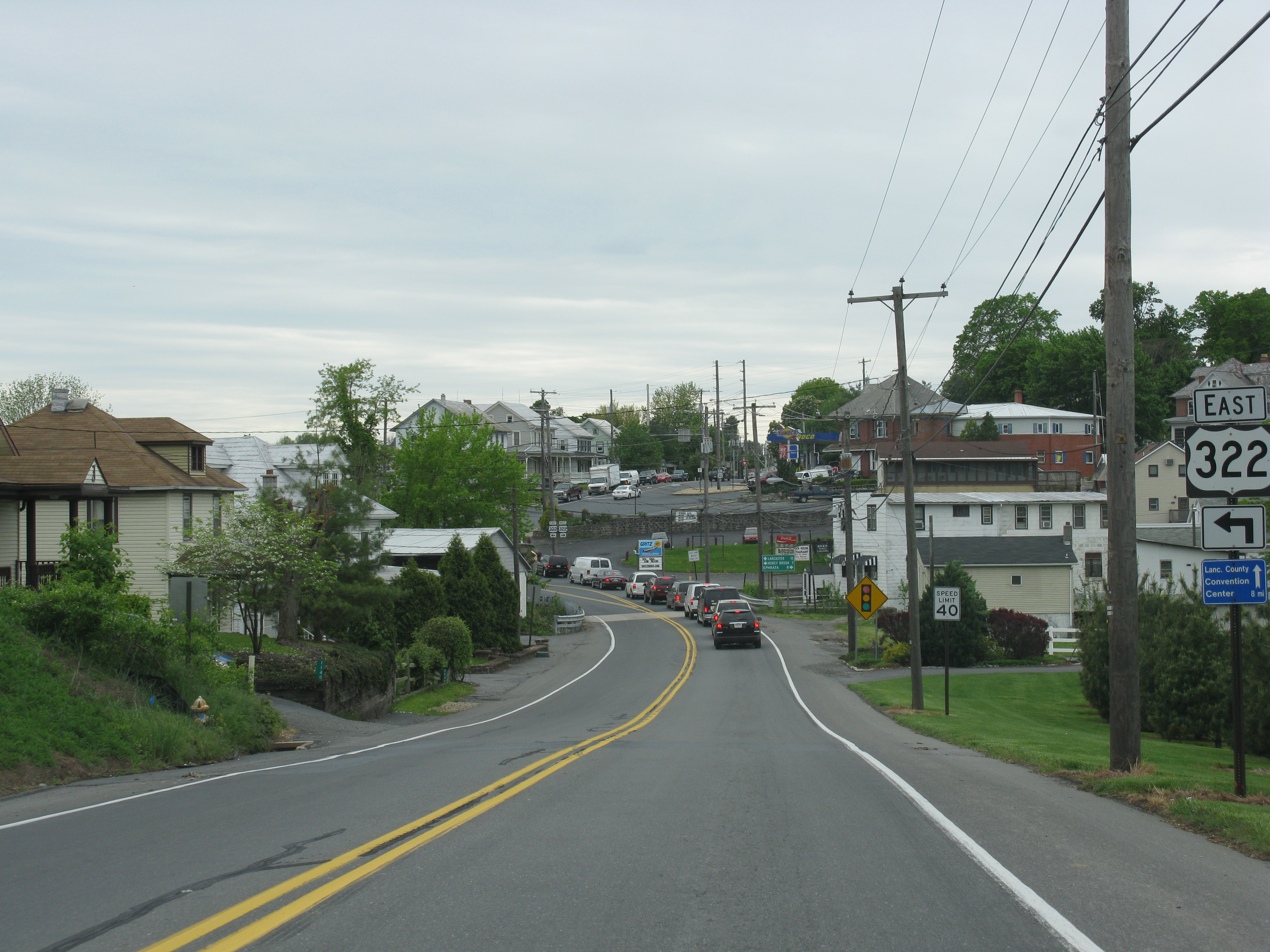
 US 322 east of New Holland
 I-176 in Morgantown
 US 422 in Valley Forge
 US 202 in Bridgeport
East end:  US 1 in Philadelphia
Location Counties: Berks, Chester, Montgomery, Lancaster, Philadelphia Highway system Roads in Pennsylvania
Interstate • US • State • Legislative←  PA 22
PA 22PA 24  →
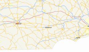
→Pennsylvania Route 23 (PA 23) is a 81.04 mi (130.42 km) state highway in southeastern Pennsylvania. The route begins at Pennsylvania Route 441 in Marietta and heads east to U.S. Route 1 in Philadelphia.
Contents
Route description
Marietta to Valley Forge
PA 23 starts in Marietta, Pennsylvania, on the Susquehanna River, and proceeds east towards Lancaster, Pennsylvania as the Marietta Pike. West of Lancaster, Route 23 passes over US 30 (which here is an expressway parallel to Lincoln Highway), with the preceding Centerville Road and subsequent PA-741 providing complete access between 23 and 30. In downtown Lancaster, Route 23 splits onto the one-way Chestnut and Walnut Streets, with the latter also carrying PA 462 westbound. PA 462 eastbound is on King Street. In downtown Lancaster, PA-23 (and 462) crosses in succession: US 222S/PA 272S at Prince Street, PA-72N at Queen Street, and US 222N/PA 272N at Lime Street. East of Lancaster, Route 23 merges with US 30 for about 1/4 mile, forming a wrong-way concurrency. Then it heads east towards Morgantown, Pennsylvania.
In Morgantown, a grade-level intersection with Interstate 176 spur provides access to and from Reading only. PA-10 North connects 23 to a complete I-176 interchange which also gives access to the Pennsylvania Turnpike, I-76. East of Morgantown the route passes through the northern Chester County towns of Elverson, Warwick, South Coventry, and East Vincent before entering Phoenixville. In Phoenixville, 23 intersects PA-29 before continuing east to Valley Forge as Valley Forge Road. From here to its end, Route 23 generally follows the course of the Schuylkill River.
Valley Forge to Philadelphia
The Route passes through Valley Forge National Historical Park, the site where George Washington and his troops made an important winter encampment during the American Revolutionary War. At the east edge of the Park, 23 has a junction with US 422. East of Valley Forge the Route crosses north of King of Prussia through Upper Merion Township toward Bridgeport. Just before Bridgeport, 23 passes over the end of the never completed Schuylkill Parkway (23 Bypass) to 422. 23 then passes under DeKalb Pike US 202S.
Upon entering Bridgeport, 23 turns left on the Schuylkill Parkway. Traffic from 202 uses ramps built for the bypass to access 23 at this point. The Parkway ends in 1/4 mile and 23 becomes 4th Street in Bridgeport. At a light, 23 crosses US 202N. Exiting Bridgeport, 23 becomes Schuylkill River Road and passes under the bridge carrying I-276, the PA Turnpike's Philadelphia Extension, across the Schuylkill River. The Route then turns generally southward with the river and skirts a large quarry opposite. The Schuylkill River Road name ends as 23 passes under the I-476/Blue Route bridge across the Schuylkill River. Entering West Conshohocken, 23 becomes Front Street.
In West Conshohocken, Front Street intersects Matson Ford Road, which provides access to the I-476/I-76 interchange ramps which are signed for PA 23. Exiting West Conshohocken, Route 23 passes under I-76 and becomes Conshohocken State Road. The river swings away to the east and then to a parallel course while Conshohocken State Road continues through suburban Lower Merion Township toward Gladwyne and on to Bala Cynwyd. In Bala Cynwyd, 23 terminates at U.S. 1/City Avenue at the Philadelphia city boundary.[2]
History and future
Eastern terminus
Until 1984, PA 23 continued east along Conshohocken State Road across US 1 to Belmont Avenue, where it was then aligned with Belmont Avenue until its terminus at U.S. Route 30/Girard Avenue.[3] Google Maps and Mapquest still show the Philadelphia County portion of Conshohocken State Road as 23 and the USGS Topographic map still has the Route 23 designation along Belmont Avenue.[4]
Schuylkill Parkway
In the 1960s plans were made to construct the Schuylkill Parkway between US Route 422 at the edge of Valley Forge Park and Bridgeport, along the Schuylkill River, to carry PA 23. Construction was started on the Bridgeport end in 1972, but stopped when PennDoT ran out of funds. Recently (c. 2006), traffic studies were funded along the current 23 alignment in Upper Merion Township to see if this bypass should be completed.[5]
U.S. Route 422 interchange
Construction started in February 2008 to reconstruct the interchange of PA 23 with US 422 westbound. The ramp from 422 west to 23 west was closed to eliminate the weave with traffic entering 422 west from 23 east. 422 west traffic for 23 west now exits on the current 23 east ramp to a new signal controlled intersection with 23 to turn left onto 23 west. The 23 east ramp onto 422 west was extended to become a third lane of 422 over the Schuylkill River to the Trooper Road/PA Route 363 exit. This is designed to help the weave that causes a major regional backup in the afternoon rush hour with traffic entering from 23 and traffic exiting 422 at 363.[6]
Goat Path Expressway
In an effort to relieve existing and expected congestion, a proposed extension to be known as the "Lancaster-Norristown Expressway" began construction in 1976. Two years later, however, the project was canceled in response to local opposition concerned about the potential for increased traffic in the area. By the time the project was canceled, the roadway had been constructed in varying degrees: clearing, grading, pavement, culverts, and/or bridgework. As much of the alignment was graded but not paved, the natural terrain remains with the distinct drainage sloping of an expressway. The former planned alignment of the PA 23 freeway was given to local farmers to use. This appearance of the currently-abandoned alignment has given rise to the colloquial name: the "Goat Path" Expressway.[7]
Major intersections
County Location Mile[1] Destinations Notes Lancaster Marietta 0.00 PA 441 (River Road)Rohrerstown 9.51  PA 741 (Rohrerstown Road)
Lancaster 11.97  PA 462 west (College Avenue)
West end of 462 westbound concurrency  US 222 / PA 272 south (Prince Street)
Southbound only 12.65  PA 72 north (Queen Street)
Northbound only 12.77 US 222 / PA 272 north (Lime Street)Northbound only 13.69 PA 462 east (Broad Street)East end of PA 462 westbound concurrency 15.32 US 30 eastInterchange, West end of US 30 concurrency,
Goat Path continues east from here.15.96 US 30 westInterchange, Eastern end of US 30 concurrency Upper Leacock Township 21.04  PA 772 west (Glenbrook Road)
West end of PA 772 concurrency 21.29 PA 772 east (Newport Road)East end of PA 772 concurrency East Earl Township 29.34 US 322 (28th Division Highway)Village of Blue Ball 29.88  PA 897 north (Weaverland Valley Road)
West end of PA 897 concurrency 30.39 PA 897 south (Springville Road)East end of PA 897 concurrency 30.71  PA 625 (Reading Road)
Southern terminus of PA 625 Caernarvon Township 37.52  PA 10 south (Twin County Road)
West end of PA 10 concurrency Berks Morgantown 37.73 I-176Exit 2 (I-176). 38.18 PA 10 north (Cherry Street)East end of PA 10 concurrency.
To I-76/PA Tpk. - use PA 10 north.Caernarvon Township 40.40  PA 401 (Conestoga Road)
Western terminus of PA 401 Chester Elverson 41.23  PA 82 (Chestnut Street)
Northern terminus of PA 82 Warwick Township 43.52  PA 345 (Bulltown Road, Warwick Road)
South Coventry Township 50.47  PA 100 (Pottstown Pike)
East Pikeland Township 57.24  PA 724 (Schuylkill Road)
Eastern terminus of PA 724 Phoenixville 58.33  PA 113 south (Kimberton Road)
West end of PA 113 concurrency 58.78 PA 113 north (Bridge Street)East end of PA 113 concurrency 59.65  PA 29 (Main Street)
Montgomery Valley Forge 63.17  PA 252 (Valley Creek Road)
Northern terminus of PA 252 65.73 US 422 (County Line Expressway)Interchange Bridgeport 69.79 US 202 (Dekalb Pike)interchange Upper Merion Township 72.30  PA 320 (Swedeland Road)
Northern terminus of PA 320 West Conshohocken 73.73  I-76 (Schuylkill Expressway)
Exits 331-332 (I-76); to I-476 - use I-76 west. Philadelphia Philadelphia 81.04 US 1 (City Avenue)1.000 mi = 1.609 km; 1.000 km = 0.621 mi References
- ^ a b Calculated using DeLorme Street Atlas USA 2007 software
- ^ PennDOT. Philadelphia Map (Map). ftp://ftp.dot.state.pa.us/public/pdf/BPR_pdf_files/Maps/GHS/Roadnames/philadelphia_GHSN.PDF. Retrieved 2007-11-06.
- ^ "Pennsylvania Highways - PA 1 - 50". http://www.pahighways.com/state/PA1-50.html#PA23. Retrieved 2008-03-02.
- ^ USGS. Map of PA 23 entering the city of Philadelphia (Map). http://www.topoquest.com/map.asp?lat=40.00054&lon=-75.2196&symshow=n&datum=nad27&layer=DRG. Retrieved 2008-07-06.
- ^ "PA 23 Expressway - Unbuilt". http://www.phillyroads.com/roads/PA-23/. Retrieved 2008-03-02.
- ^ "Road project to begin this month". http://www.thereporteronline.com/WebApp/appmanager/JRC/Daily?_nfpb=true&_pageLabel=pg_article&r21.content=/TRO/_RSSFeed/TopStories/TopStoryList_Story_1525695&r21.pgpath=/TRO/News. Retrieved 2008-03-02.[dead link]
- ^ "Pennsylvania 23 Environmental Impact Statement: Project History". PennDOT. http://www.paroute23.com/about_project/history.htm. Retrieved 2007-11-06.
External links
Roads in the Susquehanna Valley Beltway Interstate Highways U.S. Routes Limited-access Pennsylvania Routes Other Pennsylvania Routes PA 17 · PA 23 · PA 25 · PA 34 · PA 39 · PA 72 · PA 74 · PA 94 · PA 114 · PA 117 · PA 147 · PA 174 · PA 225 · PA 230 · PA 233 · PA 235 · PA 241 · PA 274 · PA 325 · PA 340 · PA 341 · PA 343 · PA 419 · PA 441 · PA 443 · PA 462 · PA 465 · PA 501 · PA 533 · PA 641 · PA 645 · PA 696 · PA 722 · PA 743 · PA 772 · PA 849 · PA 850 · PA 897 · PA 934 · PA 944 · PA 997 · PA 999Other Quadrant Routes Other notable roads Road transportation infrastructure of the metro Philadelphia area Interstates U.S. Routes Pennsylvania Routes New Jersey Routes Delaware Routes Named roads/streets Benjamin Franklin Parkway · Broad Street · City Avenue · Front Street · Girard Avenue · Market Street · Roosevelt Boulevard · South Street · Chestnut Street · Walnut Street
Pennsylvania Turnpike · New Jersey Turnpike · Delaware Turnpike · Atlantic City Expressway · Schuylkill Expressway · Delaware Expressway · Blue Route · Vine St Expressway · North South Freeway · Lancaster Avenue · Bethlehem Pike · Baltimore Pike · Black Horse PikeBridges Delaware Memorial Bridge · Commodore Barry Bridge · Walt Whitman Bridge · Ben Franklin Bridge · Betsy Ross Bridge · Tacony–Palmyra Bridge · Burlington–Bristol Bridge · Delaware River – Turnpike Toll Bridge
Categories:- State highways in Pennsylvania
- Streets in Philadelphia, Pennsylvania
- Transportation in Lancaster, Pennsylvania


Wikimedia Foundation. 2010.