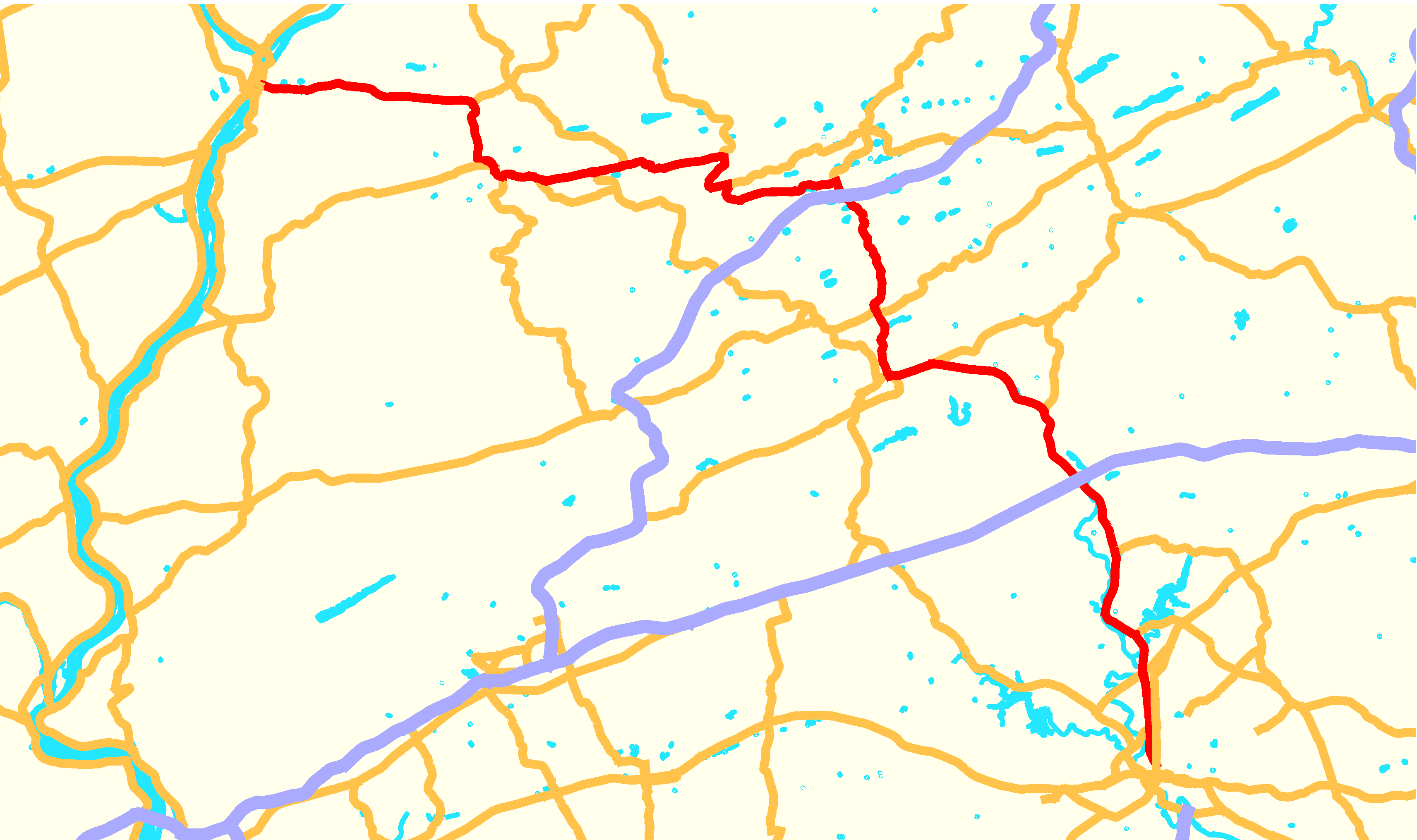
- Pennsylvania Route 61
-
PA Route 61
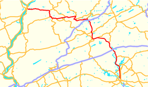
Route information Maintained by PennDOT Length: 81.14 mi[1] (130.58 km) Existed: 1963 – present Major junctions South end: 


 US 222 Bus. in Reading
 PA 12 in Reading
US 222 in Reading

 I-78 / US 22 near Hamburg
 US 209 in Pottsville
 I-81 in Frackville
 PA 147 in Sunbury
North end: 
 US 11 / US 15 in Shamokin Dam
Location Counties: Berks, Schuylkill, Columbia, Northumberland, Snyder Highway system Roads in Pennsylvania
Interstate • US • State • Legislative←  PA 60
PA 60US 62  →
→Pennsylvania Route 61 is an 81.14 mi (130.58 km)-long state highway in the U.S. state of Pennsylvania. The route is signed on a north–south direction, from U.S. Route 222 Business in Reading to U.S. Route 11 and U.S. Route 15 in Shamokin Dam. PA 61 meets up with Pennsylvania Route 54 in Ashland and these highways split just outside of Ashland. PA 54 goes towards Mount Carmel and PA 61 heads towards Centralia.
PA 61 was assigned in 1963, comprising the section of the decommissioned U.S. Route 122 from Sunbury to Reading.
Contents
Route description
Berks County
PA 61 begins at the intersection of Centre Avenue and North Fifth Street (US 222 Business) in downtown Reading, Berks County. The first three blocks of Centre Avenue are restricted to northbound travel, forcing PA 61 southbound to take the southbound-only North Fourth Street to Greenwich Street to access US 222 Business. At Fourth Street, Centre Avenue becomes bi-directional, allowing the city street to carry both directions of PA 61. The road continues northward through the city, paralleling the Schuylkill River for a short distance prior to interchanging with Pennsylvania Route 12, the Warren Street Bypass, on the northern edge of Reading.
In the inner ring of suburbs surrounding Reading, PA 61 becomes the Pottsville Pike in Muhlenberg Township roughly two miles south of an interchange with U.S. Route 222 on the bank of the Schuylkill. On the opposite side of US 222, the surrounding of PA 61 changes rapidly, transitioning from tightly-packed suburbs to scattered communities. Near Leesport, three miles (5 km) from US 222, PA 61 meets the western terminus of Pennsylvania Route 73. The route then passes through Leesport and begins to parallel the Schuylkill once more.
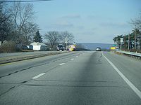
At Shoemakersville, the now-four lane, divided highway PA 61 breaks from the river and runs along the eastern edge of the borough, intersecting the northern terminus of Pennsylvania Route 662 near the center of town. In Hamburg, PA 61 and the Schuylkill River meet once more, with the Schuylkill passing under PA 61 just southwest of an overpass crossing the former routing of U.S. Route 22 into Hamburg. PA 61, which skirts the western edge of the borough, meets the current routing of US 22, concurrent here with Interstate 78, at a near-complete cloverleaf interchange due west of town.
North of I-78 and US 22, PA 61 takes a notably northwest routing as it passes over the Schuylkill again and enters the appropriately named Schuylkill County.
Schuylkill County
On the opposite bank of the Schuylkill, PA 61, now carrying the name Center Street, runs along the western foot of the Blue Mountain as it enters the small community of Port Clinton. Here, PA 61 separates from the Schuylkill once more as the river heads west from the borough while PA 61 follows the Little Schuylkill River north out of town. A mile from the northern edge of the borough, PA 61 passes over the Little Schuylkill, bringing about the northern terminus of Blue Mountain.
Past the mountain and its surrounding hills, PA 61 heads northwest and, eventually, due west through moderately level terrain, intersecting Pennsylvania Route 895 and running concurrent with the route near Deer Lake in West Brunswick Township before passing south of Orwigsburg on a bypass. Through West Brunswick Township and North Manheim Township Route 61 is named Center Turnpike. Southwest of Orwigsburg, PA 61 intersects Pennsylvania Route 443, the main road through Orwigsburg. The two routes join westward to the borough of Schuylkill Haven, a short distance east of Cressona. Through the borough it is called Center Avenue. At Dock Street, PA 443 splits from PA 61, heading south into the heart of the community while PA 61 turns north and follows the now-split Schuylkill River into a valley straddling Second Mountain and Sharp Mountain.
Immediately after passing the northern edge of Sharp Mountain, PA 61 enters Pottsville, the largest community along PA 61 since its start in Reading. Just south of the city center, PA 61 intersects U.S. Route 209 at Mauch Chunk Street. North of US 209, PA 61, now named Claude A. Lord Boulevard, snakes through the heart of the community, passing along rows of houses and streets before entering a brief stretch of isolated land between Pottsville and neighboring St. Clair in Norwegian Township. Upon passing into St. Clair, PA 61, which used to enter St. Clair directly via West Russel Street and Second Street, bypasses the borough to the immediate west, merging with North Second Street north of St. Clair. Through St. Clair PA 61 is named Joseph H. Long Boulevard.
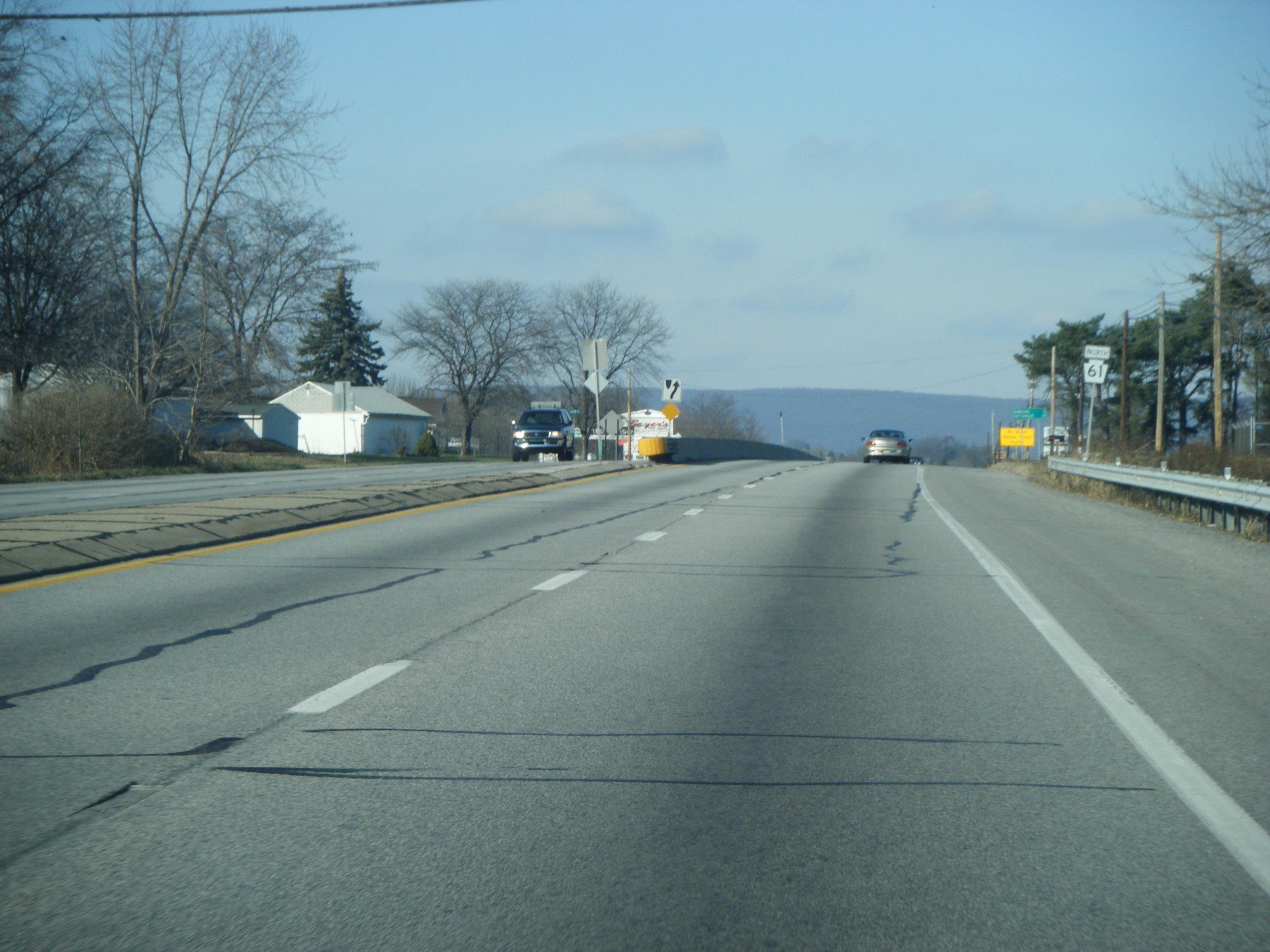
From St. Clair north, PA 61 follows the routing of Mill Creek through a series of hills and mountains, snaking along the river valley as it progresses onward. Through New Castle Township and briefly in Blythe Township it is named Skyline Drive. Roughly 1.5 miles (2.4 km) from St. Clair, the route becomes a divided highway once more, retaining this status to an interchange with Interstate 81 south of Frackville. No longer in a river valley surrounded by hills, PA 61 enters the borough on South Lehigh Avenue, meeting the southern terminus of Pennsylvania Route 924 in the center. At PA 924, PA 61 turns west onto West Oak Street, following the road as it runs through the densely-populated community and into Butler Township.
 The abandoned highway near Centralia, and its two-lane replacement
Outside of Frackville, PA 61 passes through a relatively rural area, bypassing the Ashland Reservoir to the north and Ashland Mountain to the south, heading toward the community of Fountain Springs the entire way. West of Fountain Springs, PA 61 begins to turn northward once more and enters Ashland as it returns to a due north alignment.
As South Hoffman Boulevard, PA 61 passes over Mahanoy Creek prior to entering the heart of the borough. Five blocks north of the waterway, PA 61 meets Pennsylvania Route 54 near the eastern edge of town. PA 61 turns west onto Centre Street, joining with PA 54 through Ashland. Near the western border of the borough, PA 61 turns north onto North Memorial Boulevard, breaking from PA 54 and proceeding into Columbia County.
Columbia County
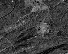
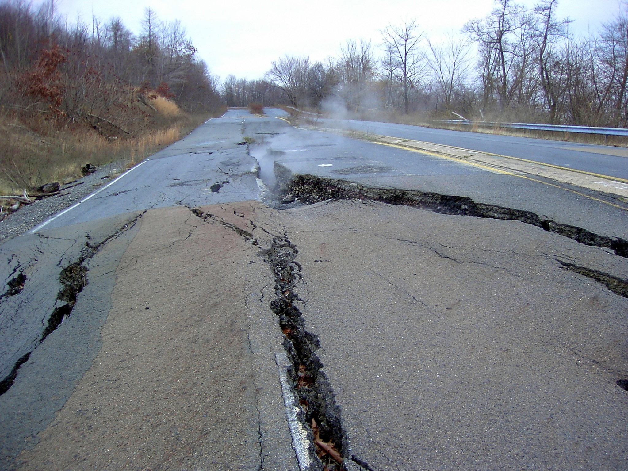
See also: Centralia, PennsylvaniaAfter crossing over the county line, PA 61 begins to curve to the northeast as it passes through a heavily rural area of eastern central Pennsylvania. Approximately three-quarters of a mile from the county line, a sharp turn deposits the four-lane PA 61 onto Byrnesville Road, a narrow two-lane road upgraded by PennDOT following the closure of a severely damaged mile-long stretch of PA 61 in 1994. After three-quarters of a mile, a clearing and an old unmaintained street, once known as Byrnesville, are visible to the south of the road. Continuing northward, the road reconnects with the old alignment of PA 61 a short distance south of Centralia.
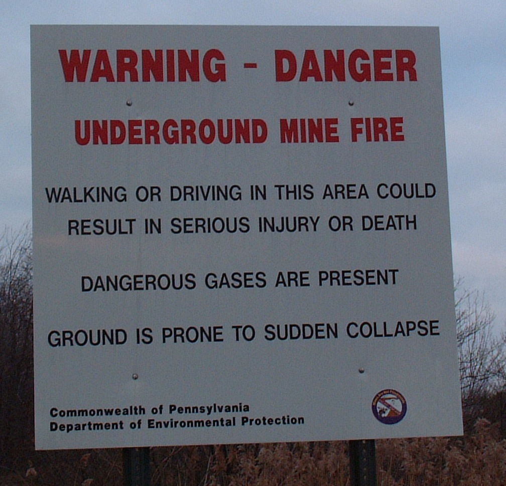
 A warning sign present at both ends of Byrnesville Road.
As in Byrnesville to the south, an underground mine fire has crippled Centralia, reducing its population to only 10 as of 2010. Signs of the town's past are evident all along PA 61, from streets and sidewalks leading away from PA 61 but seemingly heading nowhere to empty lots located throughout the town. In the center of the borough, PA 61 meets the southern terminus of Pennsylvania Route 42 at the junction of Locust Avenue and Centre Street. While PA 42 continues north on Locust Avenue, PA 61 turns west onto Centre Street, passing two all-but-barren streets before quietly exiting Centralia.
2.5 miles (4.0 km) to the west, PA 61's brief stay in Columbia County comes to an end as the route enters Northumberland County.
Northumberland and Snyder Counties
A short distance west of the county line, PA 61 enters Mount Carmel on East Fifth Street. The route heads into the heart of the large community, turning north on Market Street before resuming its westward track on East Avenue, West Avenue and Poplar Street, the latter of which leads PA 61 out of Mount Carmel to the northeast. One mile from the borough, PA 61 meets PA 54 for the second time.
West of Mount Carmel in Coal Township, PA 61 meets the western terminus of Pennsylvania Route 901 via a rare rural interchange east of Shamokin. In Shamokin, the largest city on the route since Pottsville, PA 61 meets the northern terminus of both Pennsylvania Route 125 and Pennsylvania Route 225. North of the city in the township of the same name, PA 61, a four-lane highway once more, meets the southern terminus of Pennsylvania Route 487.
Ten miles west of PA 487, the amount of development along PA 61 increases exponentially, transitioning from rural hills and land east of the Upper Augusta Township community of Oaklyn to densely-packed villages only one mile to the west in Hamilton, where PA 61 meets Pennsylvania Route 890. Through Oaklyn and Hamilton PA 61 is called State Street. The increase in development continues as PA 61 enters the city of Sunbury at Market Street and forms a concurrency with Pennsylvania Route 147 southward along the bank of the Susquehanna River at South Front Street. After three-quarters of a mile, the two routes split via a modified trumpet interchange, allowing PA 61 to access a bridge crossing the Susquehanna and terminate at an interchange with U.S. Route 11 and U.S. Route 15 in Shamokin Dam, Snyder County.
History
U.S. Routes 120 and 122
In 1926, what is now PA 61 became part of U.S. Route 120[2], from US Routes 11 and 111 in Shamokin Dam to U.S. Route 22 in Reading.[3][4] In 1935,[citation needed] US 120 was truncated to terminate at U.S. Route 220 in Lock Haven. The modern routing of PA 61 was then redesignated as part of U.S. Route 122 from U.S. Route 15 in Sunbury to U.S. Route 222 in Reading. US 122 continued south to Oxford;[5] it was first truncated to Morgantown in 1956, and then removed entirely in 1963; the part south of Reading became Pennsylvania Route 10[citation needed] while the remainder of former US 122 became PA 61.
By 1950, the roadway around Centralia was widened to 4 lanes. Also, U.S. Route 15 was moved along the westside of the Susquehanna River, and Pennsylvania Route 14 was routed along what is now PA 147.[6]
Centralia branch of PA 54/61
 A view of the closed, damaged section of PA 61 south of Centralia.
Because of the coal mine fire in Centralia, the original branch of Routes 54 and 61, which went from Centralia to Ashland, has been permanently closed because the road has severely opened up and buckled extensively. This branch was repaired in 1983 for $500,000; then in 1992 it was deemed too expensive to repair again. In 1994, the branch was permanently closed, and as of result, graffiti were scattered along the closed portion of the roadway. In 1999, Byrnesville Road (Quadrant Route 2002), located directly south of the closed section of PA 61, was upgraded and now carries PA 61, bypassing the section of PA 61 which was damaged by the underground mine fire in Centralia.[7]
PA 54 formerly ran concurrent with PA 61 through Centralia but was rerouted along Pennsylvania Route 901 and three quadrant routes in 1999, completely bypassing Centralia. Nowadays, only PA 61 goes through Centralia while PA 54 now goes directly from Ashland to Mount Carmel along the aforementioned alignment via PA 901. The road signs for PA 54 were removed from Centralia several years ago.
Routes 54 and 61 meet up again at an intersection just outside of Mount Carmel.
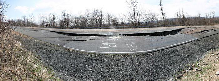 Panoramic view of the closed section of PA 61 south of Centralia
Future
As part of the Central Susquehanna Valley Transportation Project, PA 61 is planned to continue westward from its current northern terminus, ending instead at a junction with a new limited-access roadway carrying U.S. Route 15. Instead of joining with 147 briefly in Sunbury, the two will run together from the southern end of the current duplex to the new northern terminus at US 15.[8]
Major intersections
County Location Mile[1] Destinations Notes Berks Reading 0.00
US 222 Bus. (5th Street)Southern terminus 1.87 PA 12 (Warren Street Bypass)Interchange Muhlenberg Township 4.79 US 222Interchange Ontelaunee Township 6.90  PA 73
PA 73Western terminus of PA 73 Shoemakersville 12.14  PA 662 (Noble Avenue, Moselem Springs Road)
Northern terminus of PA 662 Tilden Township 16.53 I-78 / US 22Exit 29 (I-78/US 22) Schuylkill West Brunswick Township 20.90  PA 895 east
Southern terminus of concurrency 22.49 PA 895 westNorthern terminus of concurrency North Manheim Township 27.51  PA 443 east
Southern terminus of concurrency Schuylkill Haven 29.52 PA 443 west (Garfield Avenue)Northern terminus of concurrency 29.92  PA 183 (Pottsville Street)
Northern terminus of PA 183 Pottsville 33.22 US 209 (Norwegian Street)Frackville 40.60 I-81Exit 124 (I-81) 41.42  PA 924 (Lehigh Avenue)
Southern terminus of PA 924 Ashland 48.16  PA 54 east (Centre Street)
Eastern terminus of concurrency 49.14 PA 54 west (Centre Street)Western terminus of concurrency Columbia Centralia 51.20  PA 42 (Locust Street)
Southern terminus of PA 42 Northumberland Mount Carmel Township 56.67 PA 54Coal Township 61.21  PA 901
Interchange, western terminus of PA 901. Shamokin 63.30  PA 125 (Market Street)
Northern terminus of PA 125 63.59  PA 225
Northern terminus of PA 225 Shamokin Township 68.20  PA 487
Southern terminus of PA 487 Rockefeller Township 77.91  PA 890
Northern terminus of PA 890 Sunbury 79.53 PA 147 north (Front Street)Eastern terminus of concurrency 80.41 PA 147 south (Front Street)Western terminus of concurrency. Snyder Shamokin Dam 81.14 US 11 / US 15Interchange, northern terminus 1.000 mi = 1.609 km; 1.000 km = 0.621 mi PA 61 Truck

PA Route 61 Truck
Location: Sunbury Existed: 1970–present Pennsylvania Route 61 Truck is the name of two separate routes through Sunbury, Pennsylvania. Together, they help larger vehicles avoid a narrow plaza area and a tight intersection with Pennsylvania Route 147. The one-mile designation of the loop along Chestnut Street, which travels two blocks to the south of the main route through the city center, funnels traffic that is continuing along Route 61 or that needs to access Route 147 southbound. A similar route branches off of the mainline at 5th Street and travels two blocks to the north along Arch Street to reach Route 147 northbound.
References
- ^ a b DeLorme Street Atlas USA 2007 Software, Toggle Measure Tool
- ^ OKDOT. 1926 United States Numbered Highways (Map). http://www.okladot.state.ok.us/hqdiv/p-r-div/maps/misc-maps/1926us.pdf. Retrieved 2007-07-24.
- ^ Pennsylvania Department of Highways (1929). Central Pennsylvania Map (Map). http://www.broermapsonline.org/members/NorthAmerica/UnitedStates/Midatlantic/Pennsylvania/bluebook1929_037.html. Retrieved 2007-07-24.
- ^ Pennsylvania Department of Highways (1929). Allentown, Bethlehem, Marcus Hook, Chester, Reading, and Wilmington (DE) map (Map). http://www.broermapsonline.org/members/NorthAmerica/UnitedStates/Midatlantic/Pennsylvania/bluebook1929_003.html. Retrieved 2007-07-24.
- ^ Pennsylvania Department of Highways (1940). State map front side (Map). ftp://ftp.dot.state.pa.us/public/pdf/BPR_pdf_files/Maps/Statewide/Historic_OTMs/1940fr.pdf. Retrieved 2007-07-24.
- ^ Pennsylvania Department of Highways (1950). State map front side (Map). ftp://ftp.dot.state.pa.us/public/pdf/BPR_pdf_files/Maps/Statewide/Historic_OTMs/1950fr.pdf. Retrieved 2007-07-24.
- ^ Currie, Tyler (April 2, 2003). "Zip Code 00000". The Washington Post. http://www.washingtonpost.com/wp-dyn/content/article/2003/04/02/AR2005033108150.html. Retrieved February 11, 2010.
- ^ Central Susquehanna Valley Transportation Project: Proposed Roadway Route Designations
External links
Categories:- State highways in Pennsylvania
- Transportation in Berks County, Pennsylvania
- Transportation in Schuylkill County, Pennsylvania
- Transportation in Columbia County, Pennsylvania
- Transportation in Northumberland County, Pennsylvania
- Transportation in Snyder County, Pennsylvania


Wikimedia Foundation. 2010.