- Pennsylvania Route 73
-
PA Route 73
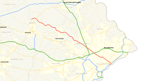
Route information Maintained by PennDOT Length: 62.51 mi[3] (100.60 km) Existed: 1928[1][2] – present Major junctions West end:  PA 61 in Leesport
 US 222 in Maiden Creek
 PA 100 in Boyertown
 US 202 in Blue Bell
 PA 309 in Springfield
 US 1 in Philadelphia
East end:  Route 73 in Philadelphia
Location Counties: Berks, Montgomery, Philadelphia Highway system Roads in Pennsylvania
Interstate • US • State • Legislative←  PA 72
PA 72PA 74  →
→Pennsylvania Route 73 (PA 73) is a 62.51 miles (100.60 km) long east–west state highway in southeastern Pennsylvania. It runs from Pennsylvania Route 61 in Leesport to the New Jersey state line on the Tacony-Palmyra Bridge in Philadelphia, where it continues as New Jersey Route 73.
Predating the Interstate and U.S. Highway Systems, the Skippack Pike, a modern section of the route, served as the primary connector between Philadelphia and the northwest suburbs.
Contents
Route description
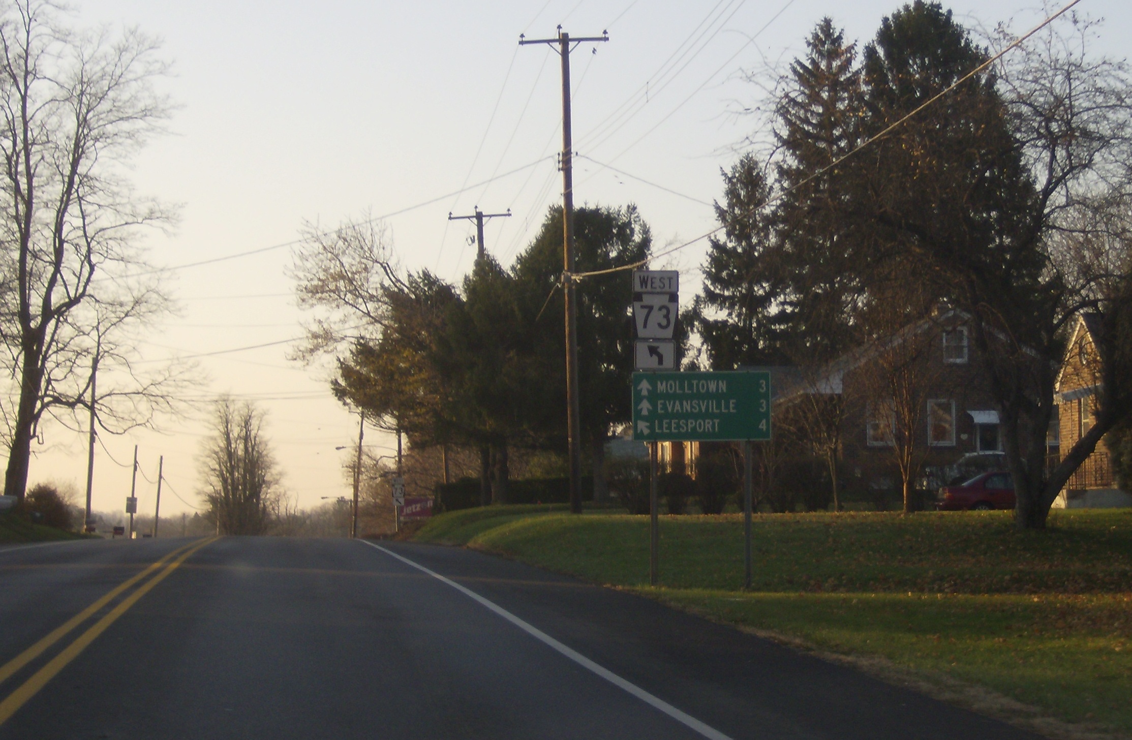
Berks County
 Route 73 in Berks County, near its western terminus
PA 73 begins at an intersection with Pennsylvania Route 61 in Leesport, north of Reading. It runs east along the shore of Lake Ontelaunee, intersecting U.S. Route 222 in Maiden Creek. Southeast of Maiden Creek, the route runs southeast, traversing a small mountainous region of the county. PA 73 intersects with Pennsylvania Route 12 near Pricetown and Pennsylvania Route 662 in Oley. It enters Boyertown as Philadelphia Avenue, meeting the eastern terminus of Pennsylvania Route 562 in the middle of town, and entering Montgomery County at the Boyertown-Gilbertsville border.[4][5][6]
Montgomery County
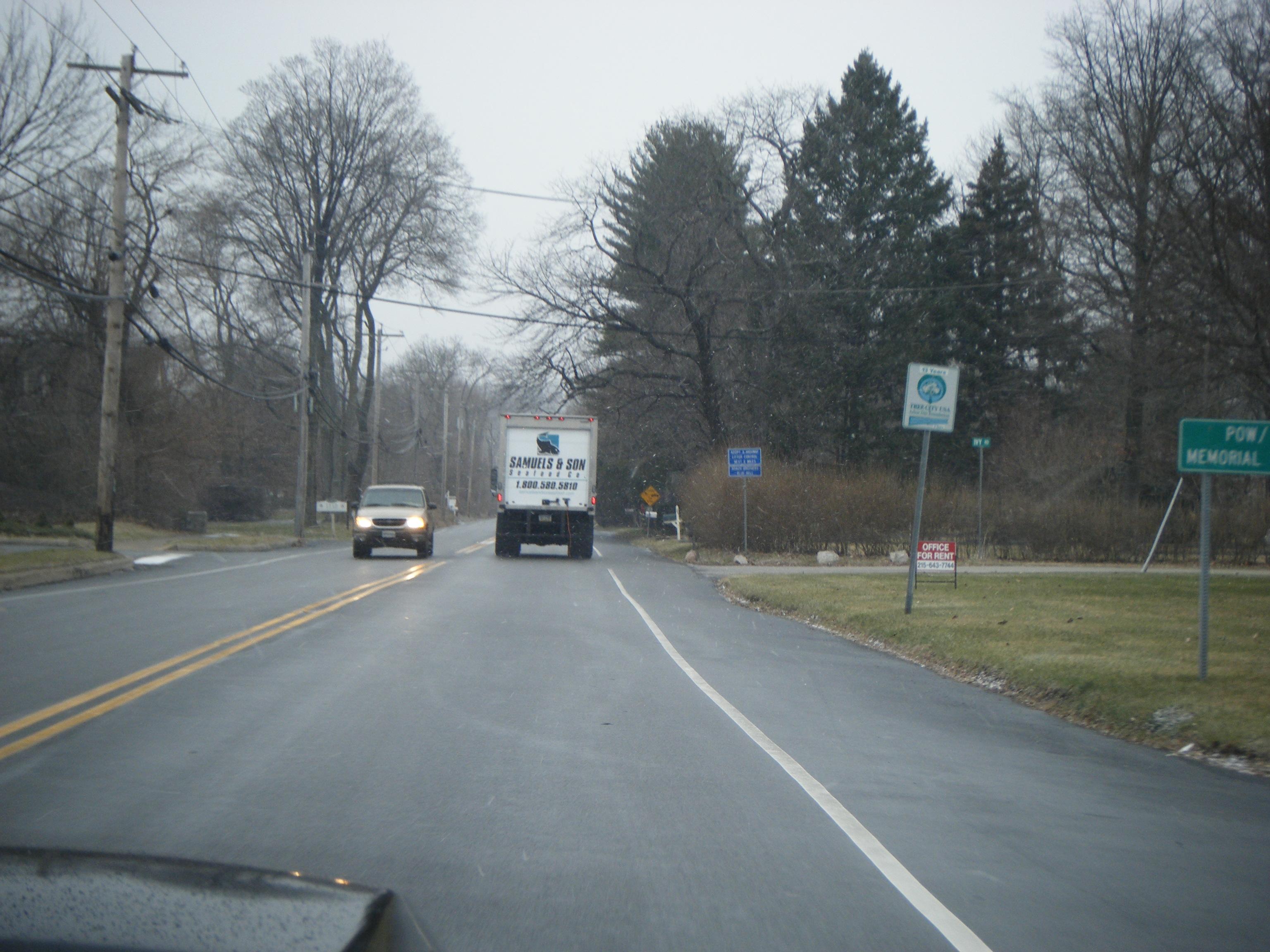
 PA 73 westbound in Whitpain Township past Butler Pike.
On the county border, PA 73 interchanges with Pennsylvania Route 100, then continues southeast through Gilbertsville. In contrast to the mountainous Berks County terrain of 73, the elevation in Montgomery is much less, ranging from 100 feet (30 m) to 350 feet (106 m) above sea level. It then heads east as Big Road, where Pennsylvania Route 663 briefly joins the route from the south before leaving again on its own alignment. PA 73 continues southeast through Frederick and Zieglerville, where it joins with Pennsylvania Route 29 to head south on Gravel Pike, paralleling the Perkiomen Creek and Perkiomen Trail. The road turns into Main Street through central Schwenksville. PA 73 leaves for its own alignment, known as Skippack Pike, south of Schwenksville, crossing the Skippack Creek before heading southeast once again, entering the outer suburbs of Philadelphia.[7]
The route continues past Graterford Prison[8], entering central Skippack, where it meets Pennsylvania Route 113. It briefly crosses Evansburg State Park, intersecting Bustard Road which provides access to Interstate 476 before heading through Worcester Township, where it intersects Pennsylvania Route 363. It passes under Interstate 476 without a direct interchange before entering Blue Bell, where it intersects with U.S. Route 202. It continues southeast through Blue Bell, passing Fort Washington State Park before crossing the Wissahickon Creek, and turning south onto Bethlehem Pike for a brief distance before again turning east onto Church Road.[9]
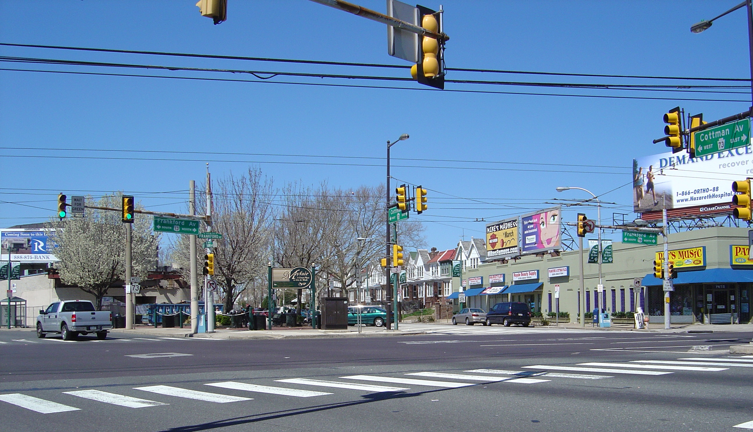
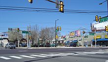 Cottman (PA-73) and Frankford Avenues, a central location in Northeast Philadelphia
PA 73 continues east through the densely populated northern Philadelphia suburbs, interchanging with the Fort Washington Expressway in Springfield, and with Pennsylvania Route 152 in Glenside. It briefly turns northwest onto Washington Lane before heading southeast again onto Township Line Road, which forms the boundary between Cheltenham and Abington townships. It intersects with Pennsylvania Route 611 before entering the city of Philadelphia.[10][11]
Philadelphia
The road continues as Cottman Avenue through Northeast Philadelphia, meeting Pennsylvania Route 232 at an intersection locally known as the Five Points.[12] Passing through the Lawncrest and Rhawnhurst neighborhoods, it intersects Roosevelt Boulevard (US 1) at a massive interchange near Pennypack Park with PA 73 intersecting the outer six lanes of the Boulevard while the inner six pass under Cottman. It continues through the Mayfair neighborhood, meeting U.S. Route 13 on Frankford Avenue. It then briefly operates as a one-way pair along Torresdale and Princeton Avenues and State Road and Cottman Avenue, before interchanging with Interstate 95 and turning southwest onto New State Road. This road turns into a traffic circle at the foot of the Tacony-Palmyra Bridge; PA 73 traverses the circle and crosses the bridge into New Jersey, where it continues as New Jersey Route 73.[13][14]
History
 Former Reading designation of Route 73.
The Skippack Pike, a portion of PA 73 between Skippack and Bethlehem Pike in Whitemarsh, dates back to 1713, when settlers in Skippack petitioned Philadelphia officials for a road to their community for purposes of hauling grain to the mill in Whitemarsh.[15] During the American Revolutionary War, George Washington's army suffered a defeat at the Battle of Germantown on October 4, 1777 and had to encamp along the Pike until October 8. The Americans later marched east on the road while preparing for a counterattack at the Battle of White Marsh.[16]
The Skippack Turnpike Company was incorporated in 1845 to construct a turnpike from Whitemarsh to Skippack but the project was abandoned after several efforts. In 1853, a second charter was granted and the turnpike was completed in 1855 near Worcester Township.[15]
When the state began maintenance over roads via the Sproul Road Bill (signed May 31, 1911),[17] the system did not include the direct Reading–Philadelphia routes that PA 73 and U.S. Route 422 are today. PA 73 was adopted as Legislative Route 197, the main route that connected Philadelphia and its northwest suburbs. Legislative Routes paved the way for Pennsylvania's first Traffic Routes in 1924[18] and a new set of routes, including PA 73, that were added in the late 1920s.[19][20]
In the original 1928 routing, PA 73 deviated from its current route west of Manatawny to follow Hoch Road, Bertolet Mill Road, and Main Street in the hamlet of Oley. The route then turned south to leave the hamlet on what is now Friedensburg Road to Reading and continued south along the current Pennsylvania Route 625 routing to end at Pennsylvania Route 23 near Blue Ball. The highway entered the city of Reading from the south as the New Holland Road, Lancaster Avenue and Bingaman Street into downtown Reading, concurrent with U.S. Routes 122 and 222. North of the Schuylkill River crossing, PA 73 turned east to overlap U.S. Route 422 along Perkiomen Avenue. East of the city in Mount Penn, PA 73 followed Friedensburg Road to Oley. The current segment from Oley to Leesport was designated as Pennsylvania Route 383.[21][22]
PA 73 originally ended at Roosevelt Boulevard (US 1) in Northeast Philadelphia. After the Tacony-Palmyra Bridge was built in 1929,[23] the eastern terminus was moved to its current location on the bridge at the New Jersey state line. It followed Cottman Avenue, Frankford Avenue, and Levick Street into the bridge.[24] By 1966, the western terminus was moved to its current location in Leesport.[25]
Major intersections
County Location Mile[3] Destinations Notes Berks Ontelaunee Township 0.00 PA 61 (Pottsville Pike)Maidencreek Township 2.7 US 222 (Allentown Pike)Ruscombmanor Township 6.63  PA 12 (Pricetown Road)
Oley Township 8.84  PA 662 north (Memorial Highway)
Western terminus of concurrency 10.51 PA 662 south (Memorial Highway)Eastern terminus of concurrency Boyertown 20.21  PA 562 (Reading Avenue)
Eastern terminus of PA 562 Montgomery Douglass Township 21.17 PA 100Interchange New Hanover Township 24.30  PA 663 south (North Charlotte Street)
Western terminus of concurrency 24.54 PA 663 north (Layfield Road)Eastern terminus of concurrency Lower Frederick Township 30.16  PA 29 north (Gravel Pike)
Western terminus of concurrency Perkiomen Township 32.41 PA 29 south (Gravel Pike)Eastern terminus of concurrency Skippack Township 36.06  PA 113 (Bridge Road)
Worcester Township 39.78  PA 363 (Valley Forge Road)
Whitpain Township 43.58 US 202 (Dekalb Pike)Whitemarsh Township 48.63 Bethlehem Pike Formerly US 309 Springfield Township 49.67 PA 309 (Fort Washington Expressway)Interchange Cheltenham Township 52.16  PA 152 (Limekiln Pike)
54.41  PA 611 (Old York Road)
Philadelphia Philadelphia 57.22  PA 232 (Oxford Avenue)
59.15 US 1 (Roosevelt Boulevard)60.03  US 13 (Frankford Avenue)
61.04  I-95
I-95Exit 30 (I-95) 62.51 Route 73 (Tacony-Palmyra Bridge)Continuation into New Jersey 1.000 mi = 1.609 km; 1.000 km = 0.621 mi References
- ^ Pennsylvania Department of Highways (1927). Pennsylvania Highway Map (Map). http://www.mapsofpa.com/roadcart/1927_2043m.jpg. Retrieved 2007-11-08.
- ^ Gulf Oil (1928). Pennsylvania Highway Map (Philadelphia Metro) (Map). http://www.mapsofpa.com/art5pics/1928phila3.jpg. Retrieved 2007-11-08.
- ^ a b Calculated using DeLorme Street Atlas USA 2007 software
- ^ United States Geological Survey. Topographic Map of Ruscombmannor Township (Map). http://www.topoquest.com/map.php?lat=40.425&lon=-75.883056&datum=nad83&zoom=4. Retrieved 2007-11-09.
- ^ Google, Inc. Google Maps – Route 73 in Berks County (Map). Cartography by Google, Inc. http://maps.google.com/maps?f=q&hl=en&geocode=&time=&date=&ttype=&q=Leesport,+PA&ie=UTF8&ll=40.405131,-75.81562&spn=0.114508,0.346069&z=12&om=1. Retrieved 2007-11-09.
- ^ Pennsylvania Department of Transportation. Berks County Map (Map). ftp://ftp.dot.state.pa.us/public/pdf/BPR_pdf_files/Maps/GHS/Roadnames/berks_GHSN.PDF. Retrieved 2007-11-06.
- ^ USGS. Topographic Map of Montgomery County (Map). http://www.topoquest.com/map.asp?lat=40.14843&lon=-75.2554&symshow=n&datum=nad27&layer=DRG. Retrieved 2008-07-10.
- ^ Google, Inc. Google Maps – Hybrid Map of Graterford Prison (Map). Cartography by Google, Inc. http://maps.google.com/maps?ie=UTF8&ll=40.235869,-75.428181&spn=0.015299,0.029182&t=h&z=15&om=1. Retrieved 2007-11-26.
- ^ Google, Inc. Google Maps – Montgomery County routing of 73 (Map). Cartography by Google, Inc. http://maps.google.com/maps?f=q&hl=en&geocode=&time=&date=&ttype=&q=Ft++Washington,+PA&ie=UTF8&ll=40.200904,-75.308533&spn=0.229709,0.692139&z=11&om=1. Retrieved 2007-11-09.
- ^ Google, Inc. Google Maps – overview map of Philadelphia suburbs (Map). Cartography by Google, Inc. http://maps.google.com/maps?f=q&hl=en&geocode=&time=&date=&ttype=&q=Ft++Washington,+PA&ie=UTF8&ll=40.082143,-75.136871&spn=0.057528,0.173035&z=13&om=1. Retrieved 2007-11-09.
- ^ Pennsylvania Department of Transportation. Montgomery County Map (Map). ftp://ftp.dot.state.pa.us/public/pdf/BPR_pdf_files/Maps/GHS/Roadnames/montgomery_GHSN.PDF. Retrieved 2007-11-06.
- ^ Hall, Joan Houston (2002). Dictionary of American Regional English - Page 229. Harvard University Press. ISBN 0674008847.
- ^ Pennsylvania Department of Transportation. Philadelphia Metropolitan Map (Map). ftp://ftp.dot.state.pa.us/public/pdf/BPR_pdf_files/Maps/Statewide/OTM/2007/web_philly_enlg.pdf. Retrieved 2007-11-09.
- ^ Pennsylvania Department of Transportation. Philadelphia City Map (Map). ftp://ftp.dot.state.pa.us/public/pdf/BPR_pdf_files/Maps/GHS/Roadnames/philadelphia_GHSN.PDF. Retrieved 2007-11-06.
- ^ a b "Skippack Road History". Skippack Historical Society. http://www.skippack.org/skippackroad.htm. Retrieved 2007-11-08.
- ^ Pennsylvania History - Page 47. 64, no. 4. Pennsylvania Historical Association.
- ^ "Department of Highways". Pennsylvania Historical and Museum Commission. http://www.phmc.state.pa.us/bah/DAM/rg/sd/r12sd.htm#constructionbureau. Retrieved 2007-06-25.
- ^ "U.S. 22 - The William Penn Highway History - Pennsylvania's Named Highways". Federal Highway Administration. http://www.fhwa.dot.gov/infrastructure/us22.cfm#Pennsylvania's_Named_Highways. Retrieved 13 August 2009.
- ^ Pennsylvania Department of Highways. 1912 Montgomery County Map (Map). ftp://ftp.dot.state.pa.us/public/pdf/BPR_PDF_FILES/Maps/Type_10_GHS_Historical_Scans/Montgomery_1912.pdf. Retrieved 2007-06-25.
- ^ Pennsylvania Department of Highways. 1911 state Map, showing the early state highways (Map). ftp://ftp.dot.state.pa.us/public/pdf/BPR_pdf_files/Maps/Statewide/Historic_OTMs/1911.pdf. Retrieved 2007-06-25.
- ^ Pennsylvania Department of Highways (1930). Pennsylvania Highway Map (front side) (Map). ftp://ftp.dot.state.pa.us/public/pdf/BPR_pdf_files/Maps/Statewide/Historic_OTMs/1930fr.pdf. Retrieved 2007-11-08.
- ^ Pennsylvania Department of Highways (1930). Pennsylvania Highway Map (back side) (Map). ftp://ftp.dot.state.pa.us/public/pdf/BPR_pdf_files/Maps/Statewide/Historic_OTMs/1930bk.pdf. Retrieved 2007-11-08.
- ^ "National Bridge Inventory database". Federal Highway Administration. http://www.nationalbridges.com. Retrieved 9 November 2007.
- ^ Pennsylvania Department of Highways (1940). Pennsylvania Highway Map (back side) (Map). ftp://ftp.dot.state.pa.us/public/pdf/BPR_pdf_files/Maps/Statewide/Historic_OTMs/1940bk.pdf. Retrieved 2007-11-08.
- ^ Pennsylvania Department of Highways (1964). Berks County Map (Sheet 1) (Map). ftp://ftp.dot.state.pa.us/public/pdf/BPR_PDF_FILES/Maps/Type_10_GHS_Historical_Scans/Berks_1964_Sheet_1.pdf. Retrieved 2007-11-08.
External links
Road transportation infrastructure of the metro Philadelphia area Interstates U.S. Routes Pennsylvania Routes New Jersey Routes Delaware Routes Named roads/streets Benjamin Franklin Parkway · Broad Street · City Avenue · Front Street · Girard Avenue · Market Street · Roosevelt Boulevard · South Street · Chestnut Street · Walnut Street
Pennsylvania Turnpike · New Jersey Turnpike · Delaware Turnpike · Atlantic City Expressway · Schuylkill Expressway · Delaware Expressway · Blue Route · Vine St Expressway · North South Freeway · Lancaster Avenue · Bethlehem Pike · Baltimore Pike · Black Horse PikeBridges Delaware Memorial Bridge · Commodore Barry Bridge · Walt Whitman Bridge · Ben Franklin Bridge · Betsy Ross Bridge · Tacony–Palmyra Bridge · Burlington–Bristol Bridge · Delaware River – Turnpike Toll BridgeCommunities Educational Institutions National Historic Sites Beth Sholom Synagogue • Curtis Hall Arboretum • Wall House • Grey Towers Castle • St. Paul's Episcopal Church • Milmoral • Camptown Historic District • Rowland House • Elkins Railroad Station • Glenside Memorial HallFamous People See also Pennsylvania's 2nd congressional district • Elkins Estate • Lynnewood HallMajor Roads Regional Rail Stations Infrastructure Categories:- Streets in Philadelphia, Pennsylvania
- State highways in Pennsylvania


Wikimedia Foundation. 2010.