- Cheltenham (SEPTA station)
-
Cheltenham
SEPTA regional rail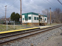
Trailer that was used as Cheltenham Station between 1993 and 2007.Station statistics Address Old Soldiers Road & Hasbrook Avenue
Cheltenham, PA 19012Coordinates 40°03′26″N 75°05′34″W / 40.057258°N 75.092722°WCoordinates: 40°03′26″N 75°05′34″W / 40.057258°N 75.092722°W Lines Fox Chase LinePlatforms 1 side platform Tracks 1 Parking 17 spaces Bicycle facilities Yes Other information Opened 1893 Rebuilt 2007 Electrified Yes Accessible 
Owned by SEPTA Fare zone 2 Formerly Cheltenham Junction Services Preceding station SEPTA Following station toward 30th Street StationFox Chase Line toward Fox ChaseCheltenham is a station located along the SEPTA Regional Rail Fox Chase Line. It is located at Old Soldiers Road and Hasbrook Avenue and has a 17-space parking lot.[1]
Until 2005, the freight and commuter rail lines shared track from Newtown Junction to a point just south of Cheltenham station, where SEPTA trains utilized a crossover to travel to/from the freight track. These tracks are now segregated, with a siding having been installed between Cheltenham and Lawndale stations for SEPTA use during peak hours. The freight line eventually merges with SEPTA's West Trenton Line between Neshaminy Falls and Langhorne Stations.
Cheltenham Station serves the Burholme neighborhood of Northeast Philadelphia and the eastern part of Cheltenham Township.
History
In 1993, the original 100-year-old station was destroyed by fire in what was ruled by the police as an arson.[2] The station was replaced with a trailer serving as the ticket office. A new station and high-level platforms were opened in October 2007.[3]
References
- ^ SEPTA webpage for Cheltenham
- ^ Delaware Valley Rail Passenger, March 1993, p.2
- ^ SEPTA Capital Improvement Report for Philadelphia, July 2006, p. 22.
External links
- Current schedule for the SEPTA Fox Chase/Newtown line
- SEPTA station page for Cheltenham
- Picture of the old station building
- Station House from Google Maps Street View
SEPTA City Transit Division Market–Frankford Line • Broad Street Line • Subway–Surface Trolley Lines (Routes 10, 11, 13, 34, and 36) • Route 15 • Trackless trolleys • City surface routesSuburban Division Regional Rail Main Line • Airport Line • Chestnut Hill East Line • Chestnut Hill West Line • Cynwyd Line • Fox Chase Line • Lansdale/Doylestown Line • Manayunk/Norristown Line • Media/Elwyn Line • Paoli/Thorndale Line • Trenton Line • Warminster Line • West Trenton Line • Wilmington/Newark LineMajor stations Frankford Transportation Center • Fern Rock Transportation Center • Market East Station • Norristown Transportation Center • Olney Transportation Center • Suburban Station • 30th Street Station • 69th Street Transportation CenterFormer services Route 23 trolley • Route 56 trolley • Route 60 trolley • Elwyn-West Chester service • Cynwyd-Ivy Ridge service • Fox Chase Rapid Transit LineCommunities Educational Institutions Points of Interest Beth Sholom Synagogue • Curtis Hall Arboretum • Wall House • Grey Towers Castle • Elkins Estate • Lynnewood HallFamous People See also Major Roads Regional Rail Stations Infrastructure Mass transit in the Delaware Valley Transit buses SEPTA: Philadelphia • Bucks, Chester, Delaware, and Montgomery counties
Reading: Berks Area Regional Transportation Authority
New Jersey Transit: Camden, Gloucester, and Salem County suburban service • Camden, Gloucester, and Salem County local service • Long-distance local routes from Philadelphia
DART First State: New Castle CountyCommuter rail SEPTA Regional Rail: Airport Line • Chestnut Hill East Line • Chestnut Hill West Line • Cynwyd Line • Fox Chase Line • Lansdale/Doylestown Line • Manayunk/Norristown Line • Media/Elwyn Line • Paoli/Thorndale Line • Trenton Line • Warminster Line • West Trenton Line • Wilmington/Newark Line
New Jersey Transit: Atlantic City Line • ACESRapid transit and light rail SEPTA: Broad Street Line • Market–Frankford Line • Norristown High Speed Line • Subway–Surface trolleys • Route 15 • Routes 101 and 102
Delaware River Port Authority: PATCO Speedline
New Jersey Transit: River Line
Other: Greenline (proposed)Related Organizations Delaware Valley Regional Planning Commission • Pennsylvania Transit Expansion Coalition (PA-TEC) • National Association of Railroad Passengers (NARP) • Delaware Valley Association of Railroad Passengers (DVARP)Categories:- SEPTA Regional Rail stations
- Stations along Reading Company lines
- Property damaged by arson
- Pennsylvania railway station stubs
- SEPTA stubs

Wikimedia Foundation. 2010.