- Pennsylvania Route 611
-
PA Route 611 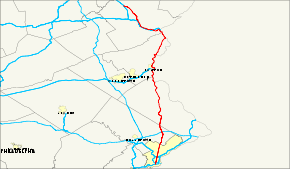
Route information Maintained by PennDOT Length: 102 mi[1] (164 km) Existed: 1972 – present Major junctions South end:  I-95 in South Philadelphia
 I-76 in Philadelphia

 I-676 / US 30 in Philadelphia
 US 1 in Philadelphia

 I-276 / Penna. Tpk. north of Willow Grove
 US 202 in Doylestown
 I-78 in Easton
 US 22 in Easton
 I-80 in Stroudsburg
North end:  I-380 in Coolbaugh Township
Location Counties: Philadelphia, Montgomery, Bucks, Northampton, Monroe Highway system Roads in Pennsylvania
Interstate • US • State • Legislative←  PA 607
PA 612  →
→←  PA 301
PA 303  →
→←  PA 826
PA 828  →
→Pennsylvania Route 611 is a major state highway in Pennsylvania, United States, running from Interstate 95 south of downtown Philadelphia north to Interstate 380 in Coolbaugh Township, Pennsylvania in The Poconos.
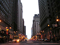
Within Philadelphia, PA 611 is also Broad Street (except for the five blocks just south of Cheltenham Avenue, where PA 611 bears right onto Old York Road), the main north–south street in Philadelphia and the traditional route for the annual Mummers Parade.
Contents
Route description
Philadelphia
Main article: Broad Street (Philadelphia)PA 611 is mostly Broad Street in Philadelphia, a major avenue that runs north and south through Central Philadelphia. PA 611 is called Broad Street for most of its route in Philadelphia, except in Center City where PA 611 runs around Philadelphia City Hall and changes its name. Also, near the northern edge of Philadelphia, PA 611 leaves Broad Street for Old York Road and exits Philadelphia. The Broad Street Line, a subway line, runs under PA 611 for most of its route in Philadelphia.
PA 611 begins at an interchange with I-95 at exit 17 in South Philadelphia, a section of Philadelphia. North of the I-95 interchange, PA 611 passes west of a sports complex that includes Citizens Bank Park, Lincoln Financial Field, Wachovia Center, and Wachovia Spectrum. PA 611 is the main access road to all of these arenas. North of the Sports area, PA 611 meets I-76 the Schuylkill Expressway which heads east towards the Walt Whitman Bridge into New Jersey. North of I-76, PA 611 meets streets like Moyamensing Ave, Oregon Ave, Passyunk Ave, and Snyder Ave. Near Center City, PA 611 meets South Street and Walnut Street. As PA 611 heads for Penn Square, PA 611 divides and runs around City Hall, also meeting the eastern terminus of PA 3 (Market Street) before becoming Broad Street again. In Center City, PA 611 meets Race Street which take passengers to the Convention Center. PA 611 meets I-676/US 30 the Vine Street Expressway in downtown Philadelphia. North of Center City in North Philadelphia, it goes past Temple University, as well as Spring Garden St, Cecil B. Moore, Glenwood, Lehigh, Allegheny, and Girard Ave. North of the Temple area, PA 611 meets US 13 as Roosevelt Boulevard. North of the intersection with US 13, PA 611 passes over US 1 with access to and from the southbound direction of that route. At the northern tip of Philadelphia, PA 611 becomes Old York Road and leaves Broad Street which continues north to PA 309. At the Philadelphia city line and in East Oak Lane, PA 611 meets the southern terminus of PA 309 (Cheltenham Avenue) at an interchange but neither PA 309 or PA 611 is a limited access road.
Montgomery County
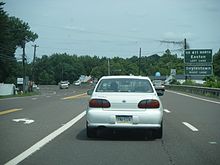
PA 611 northbound in Horsham
PA 611 enters Montgomery County as Old York Road after the interchange with PA 309. Old York Road is a historic road that connected Philadelphia to New York City. At the Abington Township/Cheltenham Township border, PA 611 meets PA 73 which is called Township Line Rd. In Willow Grove, PA 611 meets PA 63, also called Moreland Rd. The second junction in Willow Grove is the southern terminus of PA 263, southwest of Hatboro where PA 263 becomes York Rd. and PA 611 becomes Easton Rd. PA 611 meets I-276, the Pennsylvania Turnpike, at the Willow Grove (343) exit. In the community of Horsham, PA 611 meets the eastern terminus of PA 463. Also in Horsham, PA 611 passes east of Naval Air Station Willow Grove; the largest reserve base in the United States. PA 611 meets an important road at the Bucks - Montgomery county line, the road is called County Line Rd. and it divides the two counties.
Bucks County
PA 611 enters Bucks County after crossing County Line Rd. In Warrington Township, PA 611 meets the western terminus of PA 132 which is called Street Rd. As PA 611 approaches Doylestown, PA 611 becomes a freeway to bypass Doylestown and the first exit is the main street of Doylestown. In Doylestown Township west of Doylestown, marks the southern terminus of a wrong-way concurrency with US 202 at a cloverleaf interchange. The next interchange marks the northern terminus of the concurrency; it also provides access to downtown Doylestown. The next interchange is for Broad St., an access to the Bucks County courthouse. After that, there is a partial interchange with PA 313 with a northbound off-ramp, and a southbound on-ramp. A mile north of the PA 313 interchange, the freeway ends at a partial interchange and passengers coming from southbound lanes can access the Doylestown exit. In Bedminster Township., PA 611 meets the northern terminus of PA 413 and north of PA 413 in Tinicum Township. the northern terminus of PA 113. In Nockamixon Township, PA 611 meets the southern terminus of PA 412 which is a route for Nockamixon State Park via PA 563, which meets PA 412 about one-half mile north of PA 611. In Kintnersville, PA 611 meets the northern terminus of PA 32 a scenic byway for the Delaware River. North of the PA 32 intersection, PA 611 will parallel the Delaware River for most of its routing. South of Riegelsville, PA 611 meets the eastern terminus of PA 212.
Northampton County
PA 611 northbound in Easton on Larry Holmes Drive, named for former heavyweight boxing champion Larry Holmes
PA 611 enters Northampton County paralleling the Delaware River. In Williams Township, I-78 passes over PA 611 on the Interstate 78 Toll Bridge. In South Easton there are signs that lead passengers to I-78. After crossing the Lehigh River, PA 611 has entered downtown Easton as Larry Holmes Drive. In Easton, PA 611 meets Northampton Street which enters New Jersey on the Northampton Street Bridge. North of Northampton St, PA 611 meets the eastern terminus of PA 248 and meets U.S. Route 22 the Lehigh Valley Thruway at an interchange. PA 611 turns right on Garden Street and continues north. It turns right again and heads north, passing Lafayette College. As PA 611 exits the city of Easton, PA 611 is called Delaware Drive because PA 611 is paralleling the Delaware River. PA 611 does not have any major junctions in Forks, Lower Mount Bethel, and Washington Townships. In Upper Mount Bethel Township, PA 611 meets the northern terminus of PA 512. In Portland, PA 611 meets a road at an interchange that takes passengers into New Jersey crossing the Delaware River on the Portland-Columbia Toll Bridge. The road enters New Jersey and meets I-80, US 46, and NJ 94 at an interchange.
Monroe County
PA 611 enters Monroe County paralleling the Delaware River and I-80 which is in New Jersey. PA 611 passes through the Delaware Water Gap National Recreation Area south east of Stroudsburg. In Delaware Water Gap, PA 611 meet these roads that connect to I-80 at exit 310. PA 611 becomes Fox Town Hill Road and enters the borough of Stroudsburg meeting with PA 191. Note passengers that want to take I-80 east/ US 209 north continue on PA 611 and passengers that want to take I-80 west/ US 209 south have to take PA 191. PA 611 meets the eastbound lanes of I-80 and the northbound lanes of US 209 and it has access to only I-80 east/ US 209 north. In downtown Stroudsburg, PA 611 briefly joins with US 209 BUS. In Stroud Township, PA 611 meets the northern terminus of PA 33 a 29-mile (47 km) long freeway. PA 611 has access to I-80 west also at the junction with PA 33. In Pocono Township, PA 611 briefly joins with PA 715. North west of PA 715, PA 611 meets I-80 at exit 298 for the final time near The Crossing Premium Outlets, an outlet shopping center. In Swiftwater, PA 611 briefly joins with PA 314. In Mount Pocono, PA 611 joins with PA 940 meets the southern terminus of PA 196. In Coolbaugh Township, PA 611 meets PA 423 which takes passengers to I-380 south. PA 611 terminates when the lanes of PA 611 northbound enter the lanes of I-380 northbound.
History
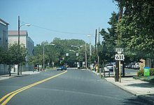
Old junction US 611 sign on Easton Road in Willow Grove in 2008. The US 611 shield is now missing from the sign.
In 1970, the section of Interstate 380 between the current exit 8 and 13 opened to traffic, and the U.S. Route 611 designation was moved onto that portion of highway. The original U.S. 611 still parallels Interstate 380 approximately 200 yards to the east through Gouldsboro State Park but is now known as Coolbaugh TR 627. [2] The road is now closed to traffic. Locally, it is often known as "Old Route 611".
Until 1972, PA State Route 611 remained designated U.S. Route 611, and continued north to U.S. Route 11 in Scranton. That same year, the portion south of Tobyhanna was decommissioned to a state highway.[3]
The stretch between Gouldsboro and Elmhurst Township is now Route 435. Route 611's southern terminus had always been in Center City Philadelphia at the junction with Route 3; it was extended south to I-95 in 1987. The overhead directional signs at the south end of the PA 611 Doylestown Bypass northbound still point towards the Bypass as "U.S. 611".
US 611 in New Jersey and US 611 Alternate
Until 1953, US 611 was exclusively in Pennsylvania. In late 1953, the Delaware Water Gap Toll Bridge and Portland-Columbia Toll Bridge were completed, as was the freeway through the Delaware Water Gap connecting them on the east (New Jersey) side of the Delaware River. The Delaware Bridge several miles south-east, which U.S. Route 46 used to cross, was abandoned at that point and later destroyed in 1955 by Hurricane Diane. The freeway had been planned as a realignment of U.S. Route 46, but instead US 611 was rerouted from its all-Pennsylvania route to cross the river twice in order to use the better-quality road on the New Jersey side. The Portland-Delaware Water Gap section of U.S. 611 became U.S. Route 611 Alternate. Route 46, therefore, no longer crossed into Pennsylvania; its western terminus became the junction with U.S. 611 at the intersection at the Portland-Columbia Toll Bridge.
North of the Portland-Columbia Bridge, the road widened from two to four lanes. Less than a mile north was a three-way intersection with only a caution light where Route 94 began and ran north. North of that intersection, Route 611 became a four-lane divided freeway and crossed the Delaware River a few miles further north on the Delaware Water Gap Toll bridge. After crossing into Pennsylvania, the divided highway narrowed again for a mile to a four lane road and curved into downtown Delaware Water Gap. There it intersected U.S. 611 Alternate and continued on to Stroudsburg. In 1959, it was announced that Interstate 80 would be designated on the freeway, and upon its completion in 1965, the road was signed as both U.S. 611 and Interstate 80. The freeway was later extended to bypass Stroudsburg, and U.S. Route 209 was realigned onto the freeway a mile past the Delaware Water Gap Bridge as well. (The old alignment of U.S. 209 was redesignated as U.S. 209 Business.)
By 1972, Interstate 80 became the exclusive route for this area of freeway, and by the end of 1973 the New Jersey portion of Interstate 80 was also complete. From 1972-73, the roads on the New Jersey side of the Delaware River were extensively realigned into a complex group of ramps. At this point, U.S. 611 was realigned to its former Pennsylvania alignment and became Pennsylvania Route 611 (due to the completion of the Interstate 380 freeway, and its terminus there 25 miles (40 km) south of U.S. 11 in Scranton). Route 94 continued to serve this new interchange, as would U.S. 46. U.S. 46 was realigned to the former U.S. 611 alignment, terminating at Interstate 80 at the new interchange. The Columbia-Portland Bridge approaches on the New Jersey side were rebuilt to feed directly into Route 94. The only U.S. 611 shield in New Jersey is located on the approach to the Columbia-Portland bridge from U.S. 46 East.
Major intersections
County Location Mile Destinations Notes Philadelphia Philadelphia 0.0  I-95 (Delaware Expressway) – Philadelphia International Airport, Central Philadelphia
Interchange  I-76 (Schuylkill Expressway) – Valley Forge, Walt Whitman Bridge
Interchange  PA 3 west (Market Street, John F. Kennedy Boulevard)
one-way pair 
 I-676 / US 30 (Vine Street Expressway)
Interchange  US 13 (Roosevelt Boulevard)
 US 1 (Roosevelt Expressway)
Interchange East Oak Lane  PA 309 north (Cheltenham Avenue)
Interchange Montgomery Cheltenham Township  PA 73 (Township Line Road)
Willow Grove  PA 63 (Moreland Road)
 PA 263 north (York Road)
Upper Moreland Township 
 I-276 / Penna. Tpk. – Philadelphia, Harrisburg, New Jersey
Interchange Horsham  PA 463 west (Horsham Road)
Bucks Warrington Township  PA 132 east (Street Road)
Doylestown South end of expressway section South Main Street Northbound exit  US 202 north – New Hope
Partial cloverleaf interchange.
South end of US 202 overlap US 202 south (West State Street) – Chalfont, Norristown
North end of US 202 overlap Broad Street  PA 313 – Dublin, Quakertown
Northbound exit Plumstead Township North Main Street Southbound exit North end of expressway section Bedminster Township  PA 413 south (Durham Road)
Tinicum Township  PA 113 south (Bedminster Road)
Nockamixon Township  PA 412 north (Durham Road)
 PA 32 south (River Road)
Durham Township  PA 212 west
Northampton Easton  To I-78 (Cedarville Road)
 PA 248 west
 US 22 (Lehigh Valley Thruway)
Interchange Upper Mount Bethel Township  PA 512 south
Monroe Smithfield Township  I-80
I-80Interchange Stroudsburg  PA 191
 I-80 / US 209
Interchange 


 US 209 Bus. north
South end of US 209 Bus. overlap 


 US 209 Bus. south
North end of US 209 Bus. overlap Stroud Township  PA 33 south
Pocono Township  PA 715 north
South end of PA 715 overlap  PA 715 south
North end of PA 715 overlap  PA 314 east
South end of PA 314 overlap  PA 314 west
North end of PA 314 overlap Mount Pocono  PA 940 east
South end of PA 940 overlap  PA 196 north
 PA 940 west
North end of PA 940 overlap Coolbaugh Township  PA 423
 I-380
I-380Attractions
- Wells Fargo Center
- Lincoln Financial Field
- Citizens Bank Park
- Philadelphia City Hall
- Pennsylvania Convention Center
References
External links
Road transportation infrastructure of the metro Philadelphia area Interstates U.S. Routes Pennsylvania Routes New Jersey Routes Delaware Routes Named roads/streets Benjamin Franklin Parkway · Broad Street · City Avenue · Front Street · Girard Avenue · Market Street · Roosevelt Boulevard · South Street · Chestnut Street · Walnut Street
Pennsylvania Turnpike · New Jersey Turnpike · Delaware Turnpike · Atlantic City Expressway · Schuylkill Expressway · Delaware Expressway · Blue Route · Vine St Expressway · North South Freeway · Lancaster Avenue · Bethlehem Pike · Baltimore Pike · Black Horse PikeBridges Delaware Memorial Bridge · Commodore Barry Bridge · Walt Whitman Bridge · Ben Franklin Bridge · Betsy Ross Bridge · Tacony–Palmyra Bridge · Burlington–Bristol Bridge · Delaware River – Turnpike Toll BridgeTransportation infrastructure of the Lehigh Valley Interstates U.S. Routes Pennsylvania Routes New Jersey Routes County Routes Named roads/streets Bridges Albertus L. Meyers Bridge · Hill to Hill Bridge · Philip J. Fahy Memorial Bridge · Minsi Trail Bridge · Easton–Phillipsburg Toll Bridge · Northampton Street Bridge · Interstate 78 Toll Bridge
Tunnels Public transportation Lehigh and Northampton Transportation Authority (Bethlehem Loop) · Trans-Bridge Lines · NJ Transit
Airports Waterways Rail Communities Abington · Ardsley · Crestmont · Elkins Park · Glenside · Hollywood · Huntingdon Valley · McKinley · Meadowbrook · Noble · North Hills · Roslyn · Roychester · Rydal · Willow GroveMajor Roads Pennsylvania Route 611Railroad Stations Education Attractions History Parks Website: Abington.orgCommunities Educational Institutions National Historic Sites Beth Sholom Synagogue • Curtis Hall Arboretum • Wall House • Grey Towers Castle • St. Paul's Episcopal Church • Milmoral • Camptown Historic District • Rowland House • Elkins Railroad Station • Glenside Memorial HallFamous People See also Pennsylvania's 2nd congressional district • Elkins Estate • Lynnewood HallMajor Roads Regional Rail Stations Infrastructure Categories:- State highways in Pennsylvania
- Limited access Pennsylvania state routes
Wikimedia Foundation. 2010.


