- Interstate 476
-
"PA 9" redirects here. PA 9 may also refer to Pennsylvania's 9th congressional district.For the 1920s route, see Pennsylvania Route 9 (1920s).
Interstate 476
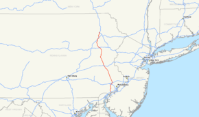
Route information Maintained by PennDOT and PTC Length: 132.10 mi[2][1][3] (212.59 km) History: Established 1964
Completed on December 16, 1992[1]Major junctions South end:  I-95 in Woodlyn
 US 1 near Springfield
 US 30 in Villanova
 I-76 in West Conshohocken

 I-276 / Penna. Tpk. in Plymouth Meeting
 US 22 near Allentown
 US 209 near Lehighton
 I-80 near Hickory Run State Park
North end: 

 I-81 / US 6 / US 11 near Clarks Summit
Location Counties: Delaware, Montgomery, Bucks, Lehigh, Carbon, Luzerne, Lackawanna Highway system Auxiliary route of the Interstate Highway System
Main • Auxiliary • BusinessRoads in Pennsylvania
Interstate • US • State • Legislative←  PA 475
PA 476  →
→←  PA 8
PA 8
PA 9  →
→←  I-479
I-479
PA 480  →
→←  PA 492
PA 501  →
→Interstate 476 is a 132.10-mile (212.59 km) auxiliary Interstate Highway in the U.S. state of Pennsylvania designated between Interstate 95 near Chester and Interstate 81 near Scranton, serving as the primary north–south Interstate corridor through eastern Pennsylvania.
Its numbering is unusual since although technically it is a spur the 4 implies that it is a bypass. It consists of both the 21.5 mile Mid-County Expressway, locally referred to as the "Blue Route" (although no signs exist with that designation), through the suburban Philadelphia counties of Delaware and Montgomery, and the 110.6 mile Northeast Extension of the Pennsylvania Turnpike connecting the Philadelphia metropolitan area with the Lehigh Valley, the Poconos, and the Wyoming Valley. The Blue Route passes through suburban areas, while the Northeast Extension predominantly runs through rural areas of mountains and farmland, with development closer to Philadelphia and in the Lehigh Valley and the Wyoming Valley. I-476 intersects many major roads including Interstate 76 (the Schuylkill Expressway) in West Conshohocken, Interstate 276 in Plymouth Meeting, U.S. Route 22 near Allentown, and Interstate 80 near Hickory Run State Park.
While proposed as early as 1929, the construction of the Mid-County Expressway through did not begin until 1967 and was not completed until 1991 due to massive community and environmental opposition during the freeway revolts of the 1960s and 1970s, leading The Philadelphia Inquirer to dub it "the most costly, most bitterly opposed highway in Pennsylvania history." In order to get the route through Delaware County built, it was built with many environmental compromises such as a parkway design and four lanes south of the Pennsylvania Route 3 interchange. The Mid-County Expressway received its "Blue Route" nickname from the chosen route through Delaware County on planning maps. Following the completion of the Mid-County Expressway, in 1996 the Interstate 476 designation was extended to include the entire length of the existing Northeast Extension, replacing PA 9. The Northeast Extension was built between 1955 and 1957 and was originally projected to continue past Clarks Summit to the New York border; however, I-81 was built between these two points instead. Since the extension, I-476 has been the longest auxiliary Interstate Highway in the United States. In addition, I-476 is longer than some main-line interstates such as Interstate 83 in Maryland and Pennsylvania, Interstate 99 in Pennsylvania, Interstate 19 in Arizona and Interstate 97 in Maryland.
Contents
Route description
Blue Route
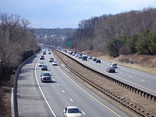 The Blue Route north of US 1.
The portion of Interstate 476 between Interstate 95 and Interstate 276 runs north–south through Delaware and Montgomery Counties and is officially known as the Mid-County Expressway and the Veterans Memorial Highway, as well as by the nickname Blue Route. The road's southern terminus is a junction with Interstate 95 near Chester, a city southwest of Philadelphia, near Philadelphia International Airport.[4] Heading north, the road immediately narrows to a four-lane parkway north of Exit 1, MacDade Boulevard. It winds through the western Philadelphia suburbs of Wallingford and Swarthmore, where I-476 comes to an interchange with Baltimore Pike. From here, the freeway continues north to Springfield, where it meets U.S. Route 1 at a three-level diamond interchange.[4]
Past US 1, I-476 continues through wooded suburban areas and interchanges with Pennsylvania Route 3 in Broomall, where it widens to six lanes.[4] The route continues to Radnor Township, on the Main Line, where it interchanges with U.S. Route 30.[4] Stone monuments, including a large stone cairn atop a hill and a large crushed-stone image of a mythological griffin on a hillside, were constructed at the Route 30 interchange to commemorate Radnor's history as part of the Welsh Tract.[5] Proceeding northward, the route enters Montgomery County and comes to an interchange with Interstate 76 (Schuylkill Expressway) at West Conshohocken. After crossing the Schuylkill River on the Pearl Harbor Memorial Bridge, the freeway heads into Plymouth Township, where it interchanges with Ridge Pike and Germantown Pike before coming to the Mid-County Interchange with the Pennsylvania Turnpike in Plymouth Meeting.[4][6]
Northeast Extension

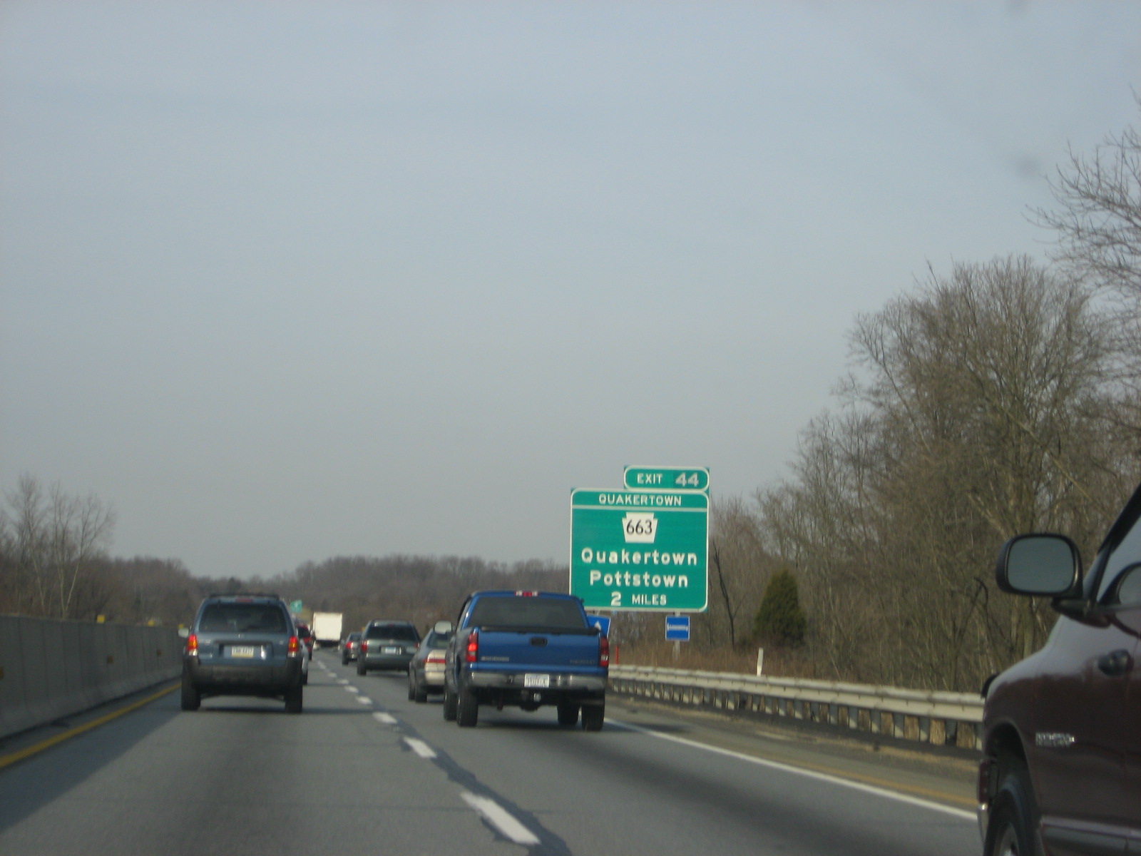
Beyond the Mid-County Interchange, Interstate 476 enters the Pennsylvania Turnpike system, interchanging with Interstate 276 and continuing north as the "Northeast Extension of the Pennsylvania Turnpike". The route continues through the Philadelphia suburbs as a four-lane road, interchanging with Pennsylvania Route 63 near Lansdale. Past this interchange, the route enters a more rural setting of woods and farms, crossing into Bucks County and coming to an interchange with Pennsylvania Route 663 near Quakertown. The Northeast Extension continues into Lehigh County, part of the Lehigh Valley metropolitan area, past the PA 663 interchange. Here, it interchanges with U.S. 22 (Lehigh Valley Thruway) near Allentown, which offers an indirect connection to Pennsylvania Route 309 and Interstate 78.[4]
North of Allentown, the route passes through more farmland before passing under the Blue Mountain in the Lehigh Tunnel and entering Carbon County in the Poconos. Here, I-476 crosses over the Lehigh River and interchanges with U.S. 209 near Lehighton. Continuing through mountainous areas, it cuts through Hickory Run State Park before interchanging with Interstate 80 and Pennsylvania Route 940 just to the north of the state park.[4] The route continues through mountainous terrain, heading into Luzerne County and coming to an interchange with Pennsylvania Route 115 in Bear Creek that provides access to nearby Wilkes-Barre.[4] The route comes to a toll barrier near Pittston that marks the northern end of the toll ticket system in the Northeast Extension.[4][7] A short distance later, an interchange with Pennsylvania Route 315 provides indirect access to Interstate 81 and Scranton. Past this interchange, I-476 enters Lackawanna County and crosses built-up areas of the Wyoming Valley and skirts around Scranton, with a mainline toll plaza and an exit to Keyser Avenue. North of Scranton in Clarks Summit, the route comes to a hairpin curve and ends at an interchange with connections to Interstate 81, U.S. Route 6 and U.S. Route 11.[6]
History
Mid-County Expressway
Originally planned as far back as 1929, the Mid-County Expressway was later proposed by the Pennsylvania Turnpike Commission as the "Chester Extension" of the Pennsylvania Turnpike in 1954. After the advent of the Interstate Highway System, the project was transferred to the Pennsylvania Department of Highways to be built as part of the system, designating it first as Interstate 495, and later as Interstate 480, as I-76 was designated as I-80S at the time. The present-day I-476 designation was assigned on February 6, 1964 when I-80S was renumbered as I-76.[8]
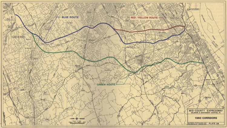
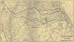 A 1960 map of central Delaware County, oriented with east on top, outlining the proposed corridors of the Mid-County Expressway.
The road received its nickname from a 1958 location report indicating various proposed geographic configurations of an expressway through Delaware County with lines of various colors on a map. The "blue route" through the Crum Creek valley won out over other contenders, which included a more easterly "red route" and "yellow route" and a more westerly "green route".[9]
As one of the most controversial Interstate Highways in Pennsylvania, construction of I-476 began in 1967, but was not completed until 1991 between MacDade Boulevard (Exit 1) and Interstate 76 (Exit 16), and until 1992 between Germantown Pike east/Chemical Road (Exit 19) and Interstate 276/Pennsylvania Turnpike (Exit 20), due to litigation between the Pennsylvania Department of Transportation and several communities in the road's path over environmental concerns. However, the section of Interstate 476 (south end of I-476) between I-95 and MacDade Blvd. (Exit 1) was opened in 1987, but the signs refer to as "To MacDade Blvd" until 1991 when I-476/The Blue Route was opened between Exits 1 and 16, and connected with the short existing section of roadway dating back to 1979 from Exit 16-Exit 19.
An agreement in 1985 led to many environmental compromises in the road's design, including a downsized four-lane design south of Pennsylvania Route 3, ramp meters, and federal scenic route status, prohibiting the erection of advertisement billboards along the entire freeway portion. While the redesigned highway was largely well-received, the constriction to four lanes has led to bottleneck conditions in the area, and many communities that originally opposed the road have now called for its widening.[10] The Philadelphia Inquirer dubbed I-476 "the most costly, most bitterly opposed highway in Pennsylvania history" due to the decades of opposition it garnered.[11]
The road is currently[update] undergoing a complete rehabilitation project, including paving, bridge repair, and ramp maintenance of the entire length of the freeway between Interstate 95 and the Pennsylvania Turnpike.[12]
The section between I-95 and I-76 was completed in 2007 and the section between I-76 and I-276 is expected to be completed by the end of 2011.
Northeast Extension
 PA 9 (1955–1996)
The Northeast Extension of the Pennsylvania Turnpike system opened in stages from November 23, 1955, to November 7, 1957, and was originally designated Pennsylvania Route 9.[13]
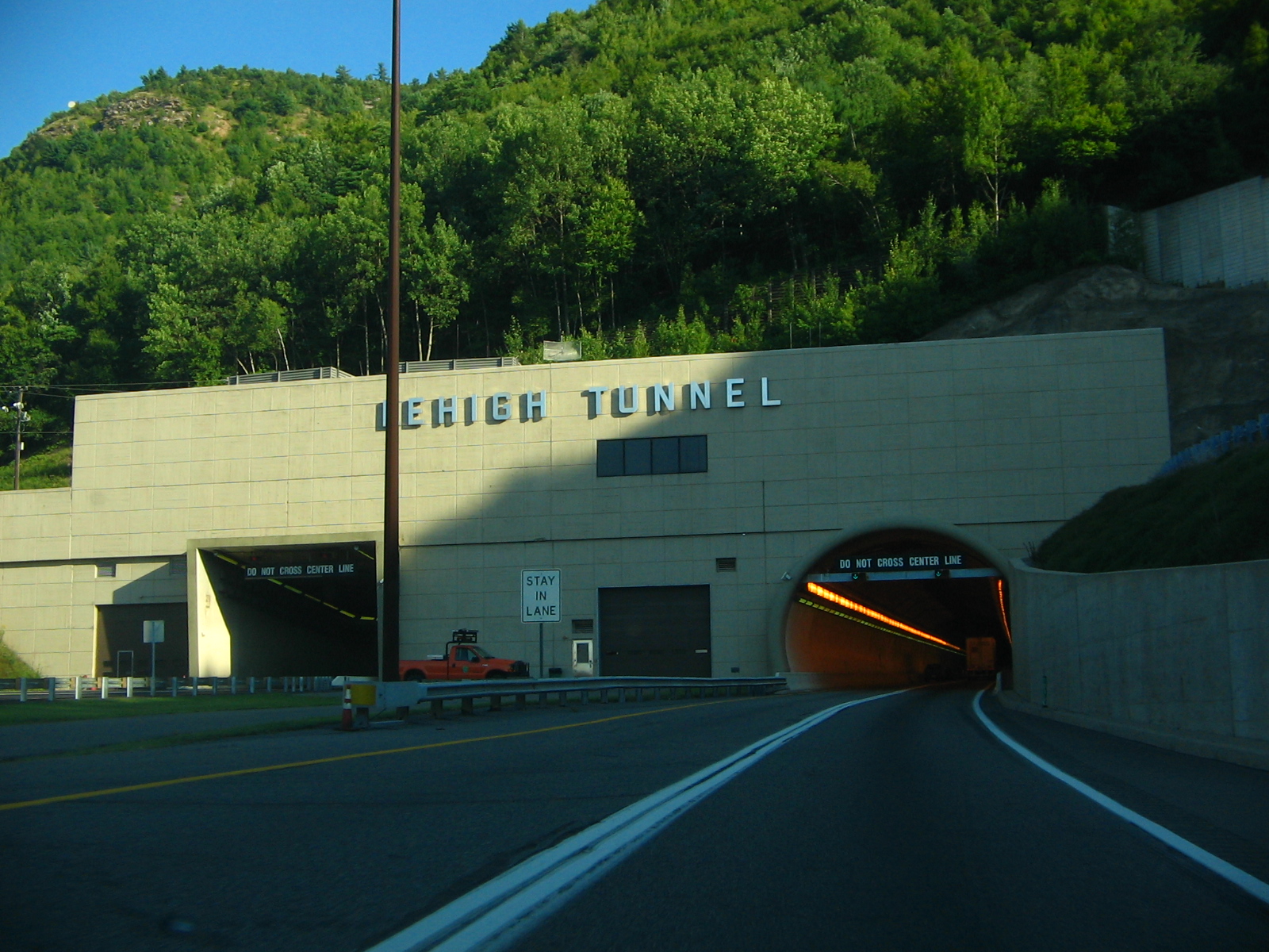
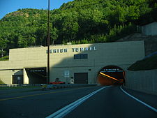 Lehigh Tunnel heading southbound
The hairpin curve at the highway's northern terminus was designed to allow for expansion northward to the New York state line. However, it was decided to incorporate this segment as part of Interstate 81 following the advent of the Interstate system.[14]
The highway includes a major, 4,461-foot (1,360 m) tunnel through Blue Mountain known as the Lehigh Tunnel. The tunnel was named as such so as not to cause confusion with the existing Blue Mountain Tunnel on the mainline. The tunnel was originally to be named for Turnpike Commission chairman Thomas J. Evans, but this was changed due to his July 25, 1967 conviction for conspiracy to defraud the Turnpike Commission of $19 million (equal to $124,982,000 today). The Lehigh Tunnel was originally a two-lane tunnel in the manner of the mainline turnpike's original seven tunnels, until it was "twinned" in 1991.[15]
In 1996, after the expansion of the Lehigh Tunnel and the completion of the I-276/I-476/PA 9 interchange, the I-476 designation was extended up the entire length of the Northeast Extension, replacing the PA 9 designation. This extension resulted in I-476 surpassing the 120-mile (190 km) Interstate 495 in Massachusetts as the longest auxiliary Interstate Highway.[16]
The Pennsylvania Turnpike Commission is in the preliminary stages of planning the widening of the Northeast Extension from Mid-County to Lansdale from 4 lanes to 6. In January 2008, work began on the replacement of two bridges over the Northeast Extension to accommodate the widened highway. The widening is expected to be complete in 2013.[17] Another project, located in Carbon County, will see the construction of a E-Z Pass-only "slip ramp" between the Mahoning Valley (74) and Pocono (95) interchanges scheduled to be completed in 2013.[18][19]
Exit list
The old exit numbers (31 and upward) on the turnpike Northeast Extension were a continuation of old exit numbers 1 through 30 on the east-west turnpike. Old exit 25A got its number from being between old exits 25 and 26 on the east–west turnpike.
County Location Mile[20] Old exit[21] New exit[21] Name Destinations Notes Delaware Woodlyn 0.00 I-95 – Philadelphia, ChesterSouthern terminus 0.48 1 1 MacDade Boulevard Access to Ridley and Chester. Springfield Township 3.39 2 3 (Baltimore Pike) Media, Swarthmore, Springfield Access to Swarthmore College. Marple Township 5.07 3 5 US 1 – Lima, Springfield8.77 4 9  PA 3 – Broomall, Upper Darby, Havertown, Newtown Square
West Chester Pike Radnor Township 13.24 5 13 US 30 – Villanova, St. DavidsAccess to Villanova University, Eastern University, Cabrini College, Harcum College, Bryn Mawr College, and Haverford College. Montgomery West Conshohocken 15.84 6 16 I-76 (Schuylkill Expressway) – Philadelphia, Valley ForgeSigned as exits 16A (east) and 16B (west) northbound 6 16  To PA 23 – Conshohocken
Signed as exit 16A northbound Plymouth Meeting 18.81 7A 18A Conshohocken (Ridge Pike east) Northbound exit and southbound entrance 18.81 7B 18B Norristown (Ridge Pike west) Signed as exit 18 southbound 19.69 8 19 Germantown Pike east – Plymouth Meeting Northbound exit and southbound entrance 9 20 To I-276 west / Penna. Tpk. west (Germantown Pike west, Plymouth Road)Northbound exit and southbound entrance 19.97 25A 20 Mid-County Toll Plaza
Northern terminus of the Blue Route, Southern terminus of the Pennsylvania Turnpike Northeast Extension20.33 20 Mid-County I-276 / Penna. Tpk. – Norristown, Harrisburg, New JerseyNorthbound exit to westbound I-276 is via exit 20 Towamencin Township 30.78 31 31 Lansdale  PA 63 – Lansdale
Bucks Milford Township 44.39 32 44 Quakertown  PA 663 – Pottstown, Quakertown
Lehigh Upper Macungie Township 56.37 Allentown Service Plaza South Whitehall Township 57.71 33 56 Lehigh Valley 
 US 22 to I-78 / PA 309 – Allentown, Harrisburg
Lehigh–
Carbon71.68 Lehigh Tunnel Carbon Franklin Township 75.73 34 74 Mahoning Valley US 209 – Stroudsburg, LehightonAccess to Pocono towns of Jim Thorpe, Lehighton, and Palmerton Penn Forest Township 86.62 Hickory Run Service Plaza 87.39  PA 903 – Jim Thorpe, Lake Harmony
Proposed E-Z Pass-only Slip Ramp. Access to Albrightsville and northern Carbon County Kidder Township 94.82 35 95 Pocono  I-80 / PA 940 – Hazleton, Mount Pocono
Luzerne Bear Creek Township 105.85 36 105 Wilkes-Barre  PA 115 – Wilkes-Barre, Bear Creek
Pittston Township 113.42 112 Wyoming Valley Toll Plaza
North end of ticket system115.17 37 115 Wyoming Valley  PA 315 to I-81 – Scranton, Pittston
Lackawanna Taylor 121.61 Keyser Avenue Toll Plaza 122.36 38 122 Keyser Avenue Keyser Avenue – Old Forge, Taylor Access to Scranton. Clarks Summit 131.20 39 131 Clarks Summit Toll Plaza 131.37 Clarks Summit I-81 / US 6 east – Binghamton, Wilkes-BarreEnd of turnpike. Access to Scranton. Clarks Summit US 11 / US 6 west – Scranton, Clarks SummitNorthbound exit and southbound entrance 1.000 mi = 1.609 km; 1.000 km = 0.621 mi There is also a small dirt road near the Haverford Township exit that takes people onto Parkview Drive, which leads to the grounds of the former Haverford State Hospital.
See also
References
- ^ a b Jeremy Rogoff; Mari A. Schaefer (2007-06-10). "No remedy soon for a clogged Blue Route". The Philadelphia Inquirer. pp. 2.
- ^ "Resurfacing" (PDF). I-476 Improvement Project. Pennsylvania Department of Transportation. http://www.476blueroute.com/pdf/pm89_handout%2003-02-06%20revised.pdf. Retrieved 2007-03-07.
- ^ "Pennsylvania Turnpike Toll/Mileage Calculator". Pennsylvania Turnpike Commission. http://www.paturnpike.com/toll/tollmileage.aspx. Retrieved 2007-03-07.
- ^ a b c d e f g h i Google, Inc. Google Maps – overview of Interstate 476 (Map). Cartography by Google, Inc. http://maps.google.com/maps?f=d&source=s_d&saddr=I-95+and+I-476+chester,+pa&daddr=I-476+%40+41.483,+-75.683&geocode=%3BFfj6eAIdSCt9-w&hl=en&mra=ls&sll=41.483505,-75.700779&sspn=0.056841,0.109863&ie=UTF8&t=h&z=8. Retrieved 2009-06-01.
- ^ Radnor Township website, Gateway Enhancement Strategy
- ^ a b Pennsylvania Department of Transportation (2006). Official Tourism and Transportation (Map). ftp://ftp.dot.state.pa.us/public/pdf/BPR_PDF_FILES/MAPS/Statewide/otm/2006/otm_2006.PDF. Retrieved 2007-03-07.
- ^ "Toll Schedule – Cash Rates". Pennsylvania Turnpike Commission. January 4, 2009. http://www.paturnpike.com/toll/images/pdfs/PTC%202009%20Cash%20Tolls%20BW%20Booklet.pdf. Retrieved 2009-06-01.
- ^ "Was I-76 Numbered to Honor Philadelphia for Independence Day, 1776?". Ask the Rambler. Federal Highway Administration. 2005-01-18. http://www.fhwa.dot.gov/infrastructure/i76.htm. Retrieved 2007-06-06.
- ^ "History of the Blue Route". I-476 Improvement Project. Pennsylvania Department of Transportation. Archived from the original on February 19, 2007. http://web.archive.org/web/20070219184651/http://www.476blueroute.com/history.htm. Retrieved 2007-06-11.
- ^ "Asphalt: the Magazine of the Asphalt Institute, Summer 1997" (PDF). http://www.asphaltinstitute.org/upload/Summer_1997.pdf. Retrieved 2007-03-07.
- ^ "FHWA By Day - December 19". http://www.fhwa.dot.gov/byday/fhbd1219.htm. Retrieved 2007-03-07.
- ^ "I-476 Improvement Project". http://www.476blueroute.com/. Retrieved 2007-03-07.
- ^ Pennsylvania Department of Transportation (1989). State Transportation, front (Map). ftp://ftp.dot.state.pa.us/public/pdf/BPR_pdf_files/Maps/Statewide/Historic_OTMs/1989fr.pdf. Retrieved 2007-06-11.
- ^ Pennsylvania Department of Transportation (1966). Lackawanna County (Map). ftp://ftp.dot.state.pa.us/public/pdf/BPR_PDF_FILES/Maps/Type_10_GHS_Historical_Scans/Lackawanna_1966.pdf. Retrieved 2007-06-11.
- ^ "Turnpike History". About the PTC. Pennsylvania Turnpike Commission. Archived from the original on February 19, 2007. http://web.archive.org/web/20070219184651/http://www.476blueroute.com/history.htm. Retrieved 2007-03-07.
- ^ "Route Log and Finder List, table 2". Federal Highway Administration. 2002-10-31. http://www.fhwa.dot.gov/reports/routefinder/table2.cfm. Retrieved 2007-03-07.
- ^ Yates, Riley. "Bridge work could slow highway traffic" The Intelligencer, January 7, 2008
- ^ www.paturnpike.com/improve/improve_map.aspx
- ^ Hartzell, Dan (October 10, 2010). "Route 903 interchange being built, expected to open in 2013.". The Morning Call. http://www.mcall.com/news/local/mc-road-warrior-turnpike-20101010,0,423189.column. Retrieved October 11, 2010.
- ^ DeLorme Street Atlas USA 2007, Toggle Measure Tool. Retrieved on 2007-02-27.
- ^ a b "Pennsylvania Exit Numbering". Pennsylvania Department of Transportation. ftp://ftp.dot.state.pa.us/public/pdf/Interstate%20exit%20numbering1.pdf. Retrieved 2007-10-02.
External links
Auxiliary routes of Interstate 76 
Auxiliary routes of Interstate 80 California: 180 (former) • 280 • 380 • 480 (former) • 580 • 680 • 780 • 880 • 880 (former) • 980 — Nevada: 580 (unsigned) — Wyoming: 180 — Nebraska: 180 • 280 (former) • 480 • 580 (former) • 680 — Iowa: 280 • 380 • 480 • 680 — Illinois: 180 • 280 — Ohio: 280 • 480 • 680 — Pennsylvania: 180 • 180 (former) • 280 (former) • 380 • 480 (former) • 680 (former) — New Jersey: 280 • 680 (former)
Interstate Highways in Pennsylvania Current Unbuilt 695 • 895Former Future Pennsylvania Turnpike Commission Completed highways 
Partially-completed highways Tunnels Aborted expansion plans Historical Tolling systems Road transportation infrastructure of the metro Philadelphia area Interstates U.S. Routes Pennsylvania Routes New Jersey Routes Delaware Routes Named roads/streets Benjamin Franklin Parkway · Broad Street · City Avenue · Front Street · Girard Avenue · Market Street · Roosevelt Boulevard · South Street · Chestnut Street · Walnut Street
Pennsylvania Turnpike · New Jersey Turnpike · Delaware Turnpike · Atlantic City Expressway · Schuylkill Expressway · Delaware Expressway · Blue Route · Vine St Expressway · North South Freeway · Lancaster Avenue · Bethlehem Pike · Baltimore Pike · Black Horse PikeBridges Delaware Memorial Bridge · Commodore Barry Bridge · Walt Whitman Bridge · Ben Franklin Bridge · Betsy Ross Bridge · Tacony–Palmyra Bridge · Burlington–Bristol Bridge · Delaware River – Turnpike Toll BridgeTransportation infrastructure of the Lehigh Valley Interstates U.S. Routes Pennsylvania Routes New Jersey Routes County Routes Named roads/streets Bridges Albertus L. Meyers Bridge · Hill to Hill Bridge · Philip J. Fahy Memorial Bridge · Minsi Trail Bridge · Easton–Phillipsburg Toll Bridge · Northampton Street Bridge · Interstate 78 Toll Bridge
Tunnels Public transportation Lehigh and Northampton Transportation Authority (Bethlehem Loop) · Trans-Bridge Lines · NJ Transit
Airports Waterways Rail Roads of the Wyoming Valley Interstate Highways Expressways U.S. Routes Pennsylvania Routes Categories:- Interstate Highways in Pennsylvania
- Delaware Valley
- Lehigh Valley
- Three-digit Interstate Highways
- Radnor Township, Delaware County, Pennsylvania
- Toll roads in Pennsylvania
- Interstate 76 (east)


Wikimedia Foundation. 2010.