- Pennsylvania Route 232
-
PA Route 232
Route information Maintained by PennDOT Length: 25.2 mi[2] (40.56 km) Existed: by 1930[1] – present Major junctions South end: 
 US 1 / US 13 in Philadelphia
North end:  PA 32 in New Hope
Location Counties: Philadelphia, Montgomery, Bucks Highway system Roads in Pennsylvania
Interstate • US • State • Legislative←  PA 231
PA 233  →
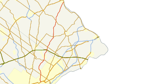
→Pennsylvania Route 232 (PA 232) is a 25.2-mile (40.6 km) long state highway located in southeastern Pennsylvania. The southern terminus of the route is at U.S. Route 1 (US 1) and US 13 at the Oxford Circle in Philadelphia. The northern terminus is at PA 32 in the borough of New Hope, Bucks County, on the banks of the Delaware River. The route passes through the urban areas of Northeast Philadelphia as two-lane undivided Oxford Avenue, serving the Lawncrest, Burholme, and Fox Chase neighborhoods. Upon entering Montgomery County, PA 232 becomes a two- to four lane road called Huntingdon Pike that passes through suburban areas, serving the communities of Rockledge, Huntingdon Valley, and Bryn Athyn. The route passes through more suburban development in Bucks County as Second Street Pike, running through Southampton and Richboro. In Wrightstown Township, PA 232 enters rural areas and becomes Windy Bush Road as it heads north to New Hope.
South of Penns Park, the road was originally known as the Fox Chase and Huntingdon Valley Turnpike or the Second Street Turnpike, a turnpike that connected farms in Bucks County to Philadelphia. When Pennsylvania first created state highways, PA 232 was designated on its current route between PA 63 in Bethayres and PA 32 in New Hope, while Pennsylvania Route 163 was designated onto current PA 232 between PA 73 in Philadelphia and PA 63. PA 232 was extended south along PA 163 by 1940 and to the Oxford Circle by 1960.
Contents
Route description
Philadelphia
 PA 232 (Oxford Avenue) in Fox Chase
PA 232 begins at Oxford Circle, where it intersects with Roosevelt Boulevard (US 1/US 13) in Northeast Philadelphia.[3] The Oxford Circle is a modified traffic circle that has direct access to the local lanes of the Roosevelt Boulevard, with the express lanes passing under it.[4] The PA 232 bridges over the Roosevelt Bouevard were constructed in 1955 and are either structurally deficient or functionally obsolete.[5][6] Here the route continues north on Oxford Avenue, a two-lane undivided surface road.[2][4] The road passes through urban areas of businesses before turning northwest into areas of rowhomes.[2] Upon reaching Har Nebo Cemetery, the route turns north through locations of homes and businesses and passes to the east of Naval Support Activity Philadelphia.[2][4]
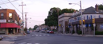
After passing the naval facility, Oxford Avenue continues northeast at the intersection with Robbins Street/Martins Mill Road.[4] PA 232 runs north through the residential Lawncrest neighborhood and reaches an intersection with Cottman Avenue (PA 73) in the Burholme neighborhood. From this junction, the route passes a mix of urban residential and commercial establishments as it comes to a 1905 bridge over CSX’s Trenton Subdivision at the Bleigh Avenue intersection and continues into the Fox Chase neighborhood, crossing SEPTA’s Fox Chase Line near the Fox Chase train station.[2][4][7] Upon reaching the Rhawn Street intersection in the downtown area of Fox Chase, the road makes a turn to the northwest.[2][4]
Montgomery County
Leaving Philadelphia at the Filmore Avenue intersection, PA 232 crosses into Montgomery County in the borough of Rockledge.[8] Here the name of the road changes to Huntingdon Pike as it passes suburban homes and businesses. Upon intersecting Fox Chase Road/Shady Lane, the route turns north and widens to four lanes as it heads into Abington Township. Here, the road passes between the Hollywood neighborhood to the west and a shopping center to the east. Farther north, PA 232 runs through wooded residential areas as it comes to the Susquehanna Road intersection. The road turns northeast at this point and passes near more homes prior to running to the southeast of Holy Redeemer Hospital, at which point it widens into a divided highway. PA 232 crosses the Pennypack Creek and the abandoned Fox Chase-Newtown rail line on 1936 bridges as it enters Lower Moreland Township at the Moreland Road intersection.[2][8][9][10] Here, the route passes over SEPTA’s West Trenton Line near the Bethayres Train Station on a 1936 bridge and crosses Welsh Road/Philmont Avenue (PA 63) in the community of Huntingdon Valley.[8][11]
Past the PA 63 intersection, PA 232 narrows into a two-lane undivided road and is lined with homes before passing a few businesses.[2] The road continues into Bryn Athyn and runs through wooded residential areas before passing between the Bryn Athyn Cathedral to the west and Bryn Athyn College to the east. The route continues into less dense wooded residential development as it briefly forms the border between Lower Moreland Township to the west and Bryn Athyn to the east before fully entering Lower Moreland Township again. The road turns northeast as it passes near a few businesses at the Byberry Road intersection before heading through wooded residential subdivisions.[2][8]
Bucks County
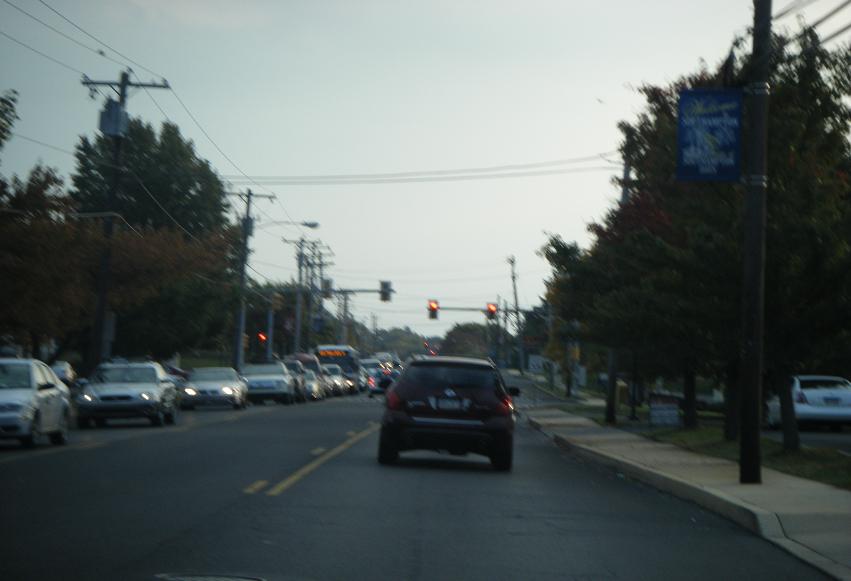
 PA 232 southbound in Upper Southampton Township.
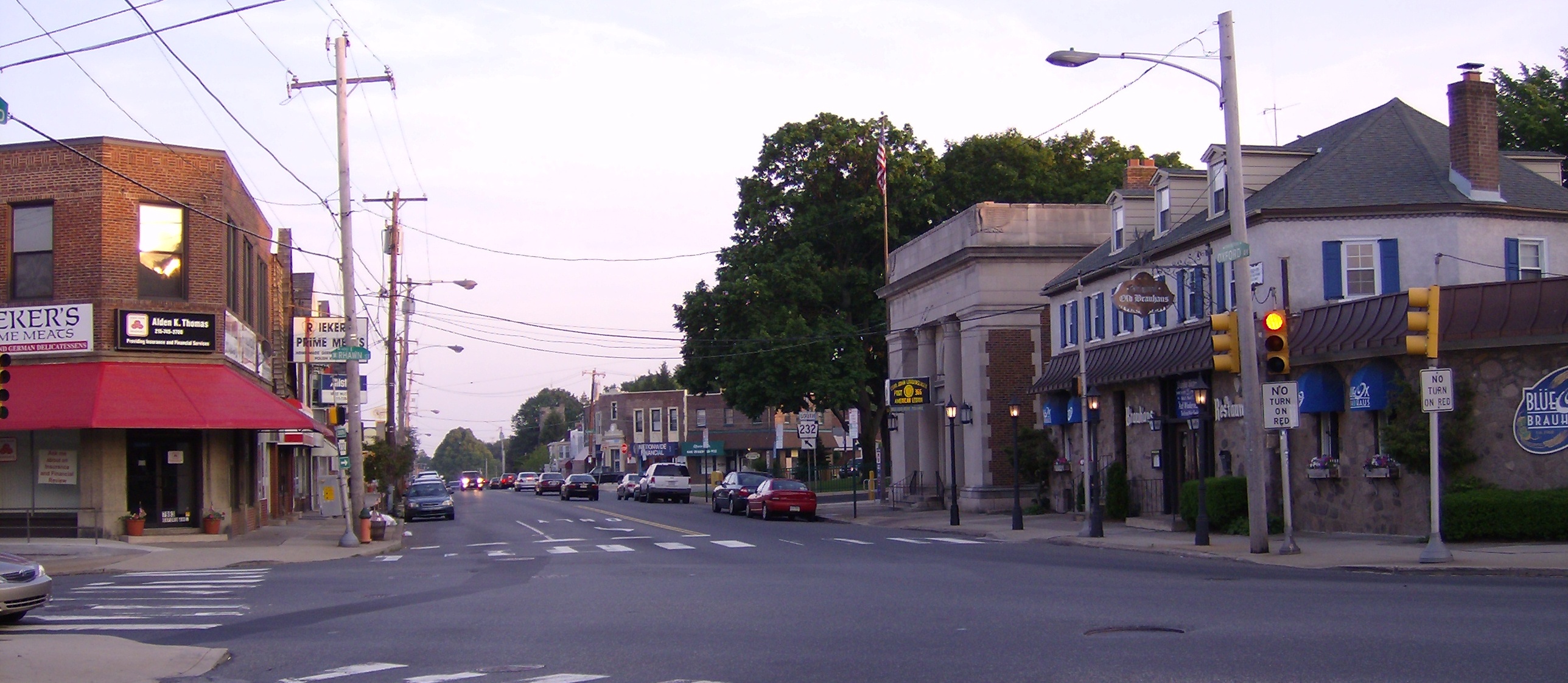
PA 232 crosses County Line Road and enters Upper Southampton Township, Bucks County.[12] Here, the road is named Second Street Pike and it heads north into business areas as a three lane road with a center left-turn lane, passing over Norfolk Southern’s Morrisville Line on a 1988 bridge before crossing over the Pennsylvania Turnpike (I-276) on a 1954 bridge.[2][12][13][14] The route crosses the abandoned Fox Chase-Newtown rail line again near the former Southampton Station before intersecting Street Road (PA 132) in the community of Southampton.[2][12]
After this intersection, the road narrows back to two lanes and turns northeast into residential areas.[2] PA 232 makes a curve to the north as it crosses Bristol Road into Northampton Township.[12] The route turns northeast again and continues past more housing developments with a few businesses.[2] At Richboro, the road passes shopping centers and businesses as Bustleton Pike merges into Second Street Pike and PA 232 continues due north. The route widens to four lanes and passes more commercial development as it crosses PA 332.[2][12] Following the PA 332 junction, the road narrows to two lanes and passes more residential areas.[2] As the route approaches the Sacketts Ford Road intersection, the settings become more rural as the road passes near farms and woods with some homes.[2][12]
The road crosses the Neshaminy Creek on a bridge completed in 1982 and turns northeast in Wrightstown Township.[2][12][15] The road continues through agricultural areas and passes to the east of a quarry following the Swamp Road intersection. PA 232 curves north again and passes a mix of rural areas and residential and commercial development prior to crossing Durham Road (PA 413) in the community of Penns Park. Now signed as Windy Bush Road, the road continues past wooded areas of homes. After the Pine Lane/Pineville Road intersection, the route enters Upper Makefield Township and continues through woodland before heading into farmland.[2][12]
A short distance past the Street Road intersection, PA 232 passes into Solebury Township and crosses the Pidcock Creek on a bridge that was finished in 1930.[2][12][16] The road continues through a mix of farms and woods with some residential areas. As the route approaches Aquetong Road, the surroundings become more forested and the road parallels Dark Hollow Run, briefly passing through farm fields.[2][12] The road enters the borough of New Hope, where it terminates at a junction with Main Street (PA 32).[12]
History
 The portion of PA 232 between PA 73 and PA 63 was once known as PA 163
In colonial times, the current alignment of PA 232 was referred to as the Middle Road because it was roughly midway between Old York Road and Bustleton Pike.[17] What is now PA 232 in Montgomery County was originally chartered in 1846 as the Fox Chase and Huntingdon Valley Turnpike. This road was a turnpike that connected the Fox Chase area and ran through eastern Montgomery County to County Line Road at the Bucks County border.[17][18] Further south into Philadelphia, the road was known variously as Oxford Avenue, Oxford Pike, and Oxford Turnpike.[17] The Fox Chase and Huntingdon Valley Turnpike was also known as the Second Street Turnpike.[19] The Second Street Pike continued the Huntington Pike north from the botder of Montgomery and Bucks counties to Wrightstown in Bucks County and served as a route for farmers into Philadelphia.[19][20][21]
By 1930, PA 232 was designated onto its current alignment between PA 63 in Bethayres and PA 32 in New Hope, with the current alignment between PA 63 south to PA 73 in Philadelphia designated as PA 163.[1] PA 232 was extended south to replace PA 163 by 1940.[22] The route was extended further south down Oxford Avenue to the Oxford Circle by 1960.[23] Since then, there have been no alignment changes to PA 232.[3]
Major intersections
County Location Mile[2] Destinations Notes Philadelphia Philadelphia 0.0 US 1 / US 13 (Roosevelt Boulevard)Oxford Circle. 2.2  PA 73 (Cottman Avenue)
Montgomery Lower Moreland Township 7.0  PA 63 (Welsh Road, Philmont Avenue)
Bucks Upper Southampton Township 11.1  PA 132 (Street Road)
Northampton Township 14.5  PA 332 (Almshouse Road, Newtown Richboro Road)
Wrightstown Township 19.3  PA 413 (Durham Road)
New Hope 25.2 PA 32 (Main Street)Northern terminus 1.000 mi = 1.609 km; 1.000 km = 0.621 mi References
- ^ a b Pennsylvania Department of Highways (1930). Tourist Map of Pennsylvania (Map). ftp://ftp.dot.state.pa.us/public/pdf/BPR_pdf_files/Maps/Statewide/Historic_OTMs/1930fr.pdf. Retrieved 2010-06-24.
- ^ a b c d e f g h i j k l m n o p q r s t u Google, Inc. Google Maps – overview of Pennsylvania Route 232 (Map). Cartography by Google, Inc. http://maps.google.com/maps?f=d&source=s_d&saddr=oxford+avenue+and+cheltenham+avenue,+philadelphia,+pa&daddr=40.14998,-75.057015+to:PA+32+and+PA+232+new+hope+pa&geocode=Fc7UYgIdW06G-ynNwxLUirbGiTH0QEHTDMysHg%3BFdyjZAIdibiG-ykJxhiU_q3GiTHrsO6EUV6DJA%3BFWrNZwIdhV2I-ymljbyvRv_DiTG8P-v80YlSYQ&hl=en&mra=ls&sll=40.20405,-75.021515&sspn=0.451006,1.352692&ie=UTF8&ll=40.182021,-74.963837&spn=0.451152,1.352692&t=h&z=10&via=1. Retrieved 2010-06-24.
- ^ a b "Pennsylvania Official Tourism and Transportation Map 2006" (PDF). PennDOT. ftp://ftp.dot.state.pa.us/public/pdf/BPR_PDF_FILES/MAPS/Statewide/otm/2006/otm_2006.PDF. Retrieved 2007-04-21.
- ^ a b c d e f ADC Map (2006). Metro Philadelphia, Pennsylvania (Map). 1"=2000' (19th ed.). ISBN 0-87530-777-0.
- ^ "NBI Structure Number: 670232000300000". National Bridge Inventory. http://nationalbridges.com/nbi_record.php?StateCode=42&struct=670232000300000. Retrieved 2010-08-31.
- ^ "NBI Structure Number: 670232000200000". National Bridge Inventory. http://nationalbridges.com/nbi_record.php?StateCode=42&struct=670232000200000. Retrieved 2010-08-31.
- ^ "NBI Structure Number: 670232006208850". National Bridge Inventory. http://nationalbridges.com/nbi_record.php?StateCode=42&struct=670232006208850. Retrieved 2010-08-31.
- ^ a b c d ADC Map (2006). Montgomery County, Pennsylvania (Map). 1"=2000' (18th ed.). ISBN 0-87530-775-2.
- ^ "NBI Structure Number: 460232006017060". National Bridge Inventory. http://nationalbridges.com/nbi_record.php?StateCode=42&struct=460232006017060. Retrieved 2010-08-31.
- ^ "NBI Structure Number: 460232006022360". National Bridge Inventory. http://nationalbridges.com/nbi_record.php?StateCode=42&struct=460232006022360. Retrieved 2010-08-31.
- ^ "NBI Structure Number: 460232007010080". National Bridge Inventory. http://nationalbridges.com/nbi_record.php?StateCode=42&struct=460232007010080. Retrieved 2010-08-31.
- ^ a b c d e f g h i j k ADC Map (2006). Bucks County, Pennsylvania (Map). 1"=2000' (19th ed.). ISBN 0-87530-774-4.
- ^ "NBI Structure Number: 090232001009430". National Bridge Inventory. http://nationalbridges.com/nbi_record.php?StateCode=42&struct=090232001009430. Retrieved 2010-08-31.
- ^ "NBI Structure Number: 097276990346820". National Bridge Inventory. http://nationalbridges.com/nbi_record.php?StateCode=42&struct=097276990346820. Retrieved 2010-08-31.
- ^ "NBI Structure Number: 090232015000000". National Bridge Inventory. http://nationalbridges.com/nbi_record.php?StateCode=42&struct=090232015000000. Retrieved 2010-08-31.
- ^ "NBI Structure Number: 090232023020540". National Bridge Inventory. http://nationalbridges.com/nbi_record.php?StateCode=42&struct=090232023020540. Retrieved 2010-08-31.
- ^ a b c Herman, Andrew Mark (1999). Eastern Montgomery County: Postcards. Arcadia Publishing. http://books.google.com/books?id=tNqs3cPGARYC&pg=PA10&dq=Fox+Chase+and+Huntingdon+Valley+Turnpike&hl=en&ei=7WElTNq6FsKqlAfUj8XAAg&sa=X&oi=book_result&ct=result&resnum=1&ved=0CCQQ6AEwADgK#v=onepage&q=Fox%20Chase%20and%20Huntingdon%20Valley%20Turnpike&f=false. Retrieved 2010-06-26.
- ^ Hamilton, A. Boyd (1856). Laws of the State of Pennsylvania Passed at the Session of 1856. Commonwealth of Pennsylvania. http://books.google.com/books?id=mdkgAAAAIAAJ&pg=PA180&dq=Fox+Chase+and+Huntingdon+Valley+Turnpike&hl=en&ei=hmElTPT9EIXGlQenwa3WAw&sa=X&oi=book_result&ct=result&resnum=3&ved=0CC8Q6AEwAg#v=onepage&q=Fox%20Chase%20and%20Huntingdon%20Valley%20Turnpike&f=false. Retrieved 2010-06-26.
- ^ a b Page, Howard W. (1916). The District Reports of Cases Decided in All the Judicial Districts of the State of Pennsylvania. Howard W. Page. http://books.google.com/books?id=j5smAQAAIAAJ&pg=PA785&dq=%22second+street+pike%22&hl=en&ei=6mAlTO2YCYP68Aags7X0Dw&sa=X&oi=book_result&ct=result&resnum=2&ved=0CC4Q6AEwAQ#v=onepage&q=%22second%20street%20pike%22&f=false. Retrieved 2010-06-26.
- ^ Herman, Andrew Mark (2000). Lower Bucks County: Postcards. Arcadia Publishing. http://books.google.com/books?id=CZSDA0deHgsC&pg=PA82&dq=Fox+Chase+and+Huntingdon+Valley+Turnpike&hl=en&ei=7WElTNq6FsKqlAfUj8XAAg&sa=X&oi=book_result&ct=result&resnum=6&ved=0CDwQ6AEwBTgK#v=onepage&q=Fox%20Chase%20and%20Huntingdon%20Valley%20Turnpike&f=false. Retrieved 2010-06-26.
- ^ Pennsylvania Department of Highways (1911). Map of Pennsylvania Showing State Highways (Map). ftp://ftp.dot.state.pa.us/public/pdf/BPR_pdf_files/Maps/Statewide/Historic_OTMs/1911.pdf. Retrieved 2010-06-24.
- ^ Pennsylvania Department of Highways (1940). Official Road Map of Pennsylvania (Map). ftp://ftp.dot.state.pa.us/public/pdf/BPR_pdf_files/Maps/Statewide/Historic_OTMs/1940fr.pdf. Retrieved 2010-06-24.
- ^ Pennsylvania Department of Highways (1960). Official Road Map of Pennsylvania (Map). ftp://ftp.dot.state.pa.us/public/pdf/BPR_pdf_files/Maps/Statewide/Historic_OTMs/1960fr.pdf. Retrieved 2010-06-25.
External links
Road transportation infrastructure of the metro Philadelphia area Interstates U.S. Routes Pennsylvania Routes New Jersey Routes Delaware Routes Named roads/streets Benjamin Franklin Parkway · Broad Street · City Avenue · Front Street · Girard Avenue · Market Street · Roosevelt Boulevard · South Street · Chestnut Street · Walnut Street
Pennsylvania Turnpike · New Jersey Turnpike · Delaware Turnpike · Atlantic City Expressway · Schuylkill Expressway · Delaware Expressway · Blue Route · Vine St Expressway · North South Freeway · Lancaster Avenue · Bethlehem Pike · Baltimore Pike · Black Horse PikeBridges Delaware Memorial Bridge · Commodore Barry Bridge · Walt Whitman Bridge · Ben Franklin Bridge · Betsy Ross Bridge · Tacony–Palmyra Bridge · Burlington–Bristol Bridge · Delaware River – Turnpike Toll BridgeCategories:- Streets in Philadelphia, Pennsylvania
- State highways in Pennsylvania


Wikimedia Foundation. 2010.