- Pennsylvania Route 332
-
PA Route 332
Route information Maintained by PennDOT Length: 13 mi (21 km) Major junctions West end:  PA 263 in Hatboro
 PA 132 in Warminster Township
 PA 232 in Northampton Township
 PA 413 in Newtown Township
 PA 532 in Newtown Township.
 I-95 in Lower Makefield Township
East end:  PA 32 in Yardley
Highway system Roads in Pennsylvania
Interstate • US • State • Legislative←  PA 331
PA 333  →
→Pennsylvania Route 332 is a state highway in the U.S. state of Pennsylvania. The route runs from Pennsylvania Route 263 in Hatboro, Montgomery County east to Pennsylvania Route 32 in Yardley, Bucks County.
Route description
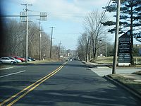 PA 332 eastbound in Warminster Township past County Line Road.
Pennsylvania Route 332 heads east from Pennsylvania Route 263 on Montgomery Avenue. Immediately after crossing the SEPTA Warminster Line tracks, the route turns north on Jacksonville Road. Pennsylvania Route 332 intersects County Line Road, and it enters Warminster Township in Bucks County. The route intersects Pennsylvania Route 132 and continues north, passing along the eastern edge of the borough of Ivyland before entering Northampton Township. Pennsylvania Route 332 continues in a northeasterly direction, eventually turning east on Almshouse Road.
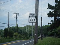 PA 332 westbound shield in Northampton Township past Hatboro Road.
Almshouse Road carries Pennsylvania Route 332 east to Richboro, where it intersects Pennsylvania Route 232. Upon crossing PA 232, Pennsylvania Route 332 changes its name to Newtown Richboro Road. Pennsylvania Route 332 then forms the southern boundary of Tyler State Park and crosses the Neshaminy Creek into Newtown Township. Pennsylvania Route 332 continues east to the Newtown Bypass, a road that provides a bypass of the borough of Newtown for Pennsylvania Route 332, along with Pennsylvania Route 413 and 532.
Pennsylvania Route 332 turns south on the Newtown Bypass, forming a concurrency with Routes 413 and 532, which bypass Newtown to the west. Eventually, both routes depart the Newtown Bypass, with Pennsylvania Route 532 first turning south to Holland, then Pennsylvania Route 413, which heads south towards Langhorne. Pennsylvania Route 332 continues east by itself, with the road name changing to Newtown Yardley Road to the east of Newtown. The road enters Lower Makefield Township, where it features an interchange with Interstate 95. The route continues east to Yardley, where it is known as Afton Avenue. Pennsylvania Route 332 continues east toward Pennsylvania Route 32, which runs along the Delaware River.
Major intersections
County Location Mile Destinations Notes Montgomery Hatboro 0.0 PA 263 (York Road)Bucks Warminster Township PA 132 (Street Road)Northampton Township PA 232 (Second Street Pike)Newtown Township PA 413 / PA 532 (Newtown Bypass)Western terminus of concurrency. PA 532 (Buck Road)Eastern terminus of concurrency. PA 413 (Newtown Langhorne Road)Eastern terminus of concurrency. Lower Makefield Township I-95Exit 49 on I-95 Yardley PA 32 (Main Street)1.000 mi = 1.609 km; 1.000 km = 0.621 mi Road transportation infrastructure of the metro Philadelphia area Interstates U.S. Routes Pennsylvania Routes New Jersey Routes Delaware Routes Named roads/streets Benjamin Franklin Parkway · Broad Street · City Avenue · Front Street · Girard Avenue · Market Street · Roosevelt Boulevard · South Street · Chestnut Street · Walnut Street
Pennsylvania Turnpike · New Jersey Turnpike · Delaware Turnpike · Atlantic City Expressway · Schuylkill Expressway · Delaware Expressway · Blue Route · Vine St Expressway · North South Freeway · Lancaster Avenue · Bethlehem Pike · Baltimore Pike · Black Horse PikeBridges Delaware Memorial Bridge · Commodore Barry Bridge · Walt Whitman Bridge · Ben Franklin Bridge · Betsy Ross Bridge · Tacony–Palmyra Bridge · Burlington–Bristol Bridge · Delaware River – Turnpike Toll BridgeCategories:- State highways in Pennsylvania


Wikimedia Foundation. 2010.