- New Jersey Route 38
-
Route 38
Kaighn Avenue 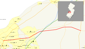
Route information Maintained by NJDOT Length: 19.19 mi[1] (30.88 km) Existed: 1927 – present Major junctions West end: 
 US 30 / US 130 in Pennsauken Township
 Route 70 in Pennsauken Township
 Route 41 in Maple Shade Township
 Route 73 in Maple Shade Township
 I-295 in Mount Laurel Township
East end: 
 US 206 / CR 530 in Southampton Township
Highway system New Jersey State Highway Routes
Interstate and US←  Route 37
Route 39  →
→Route 38 is a state highway in the southern part of the U.S. state of New Jersey serving the Philadelphia metropolitan area. It extends 19.19 mi (30.88 km) from the Airport Circle, where it intersects U.S. Route 30 and U.S. Route 130, in Pennsauken Township, Camden County to an intersection with U.S. Route 206 and County Route 530 in Southampton Township, Burlington County. The route is a four- to six-lane divided highway for most of its length and passes through commercial development, residential development, and some farmland.
Route 38 was signed in 1927, replacing part of Pre-1927 Route 18, which had run from Camden to Toms River. Route 38 was originally planned to be a freeway crossing the state of New Jersey, running from Camden to Wall Township, Monmouth County. The eastern part of this freeway would become part of Interstate 195 in the late 1960s. The freeway routing was then modified to head north of Interstate 195 to the Route 18 freeway in Colts Neck Township but was ultimately canceled by the late 1970s due to environmental and financial concerns. Route 138 was originally numbered as a segment of this Route 38 freeway, but was renumbered by the 1990s when it became apparent the freeway would not be completed.
Contents
Route description
Camden County
 Eastbound Route 38 at the interchange with County Route 644 (Haddonfield Road) in Cherry Hill Township.
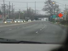
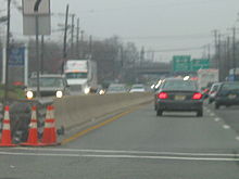
Route 38 begins at the Airport Circle junction of County Route 607 (Kaighn Avenue), U.S. Route 30, and U.S. Route 130 in Pennsauken Township, Camden County, heading east on Kaighn Avenue.[1] It meets a partial cloverleaf interchange with the western terminus of Route 70, which replaced the Browning Road Traffic Circle.[2] A six–lane divided highway separated by a Jersey barrier, it proceeds eastward, crossing into Cherry Hill Township, where it heads through commercial development.[1][3] Route 38 features cloverleaf interchanges with County Route 636 (Cuthbert Boulevard) and County Route 644 (Haddonfield Road).[1] Past the County Route 644 interchange, Route 38 passes by the Cherry Hill Mall, located on the north side of the road.[3] It proceeds through the Church Road Circle, where it crosses County Route 616 (Church Road) and County Route 627 (Coles Avenue/Cooper Landing Road).[1]
Burlington County
Route 38 crosses the South Branch of the Pennsauken Creek into Maple Shade Township, Burlington County. The route then reaches a cloverleaf interchange with Route 41 and then interchanges with Route 73.[1] The Route 38-41-73 interchange complex replaced a dangerous and congested 6-way traffic circle.[2] The route then crosses County Route 608 (Lenola Road) into Moorestown Township. Route 38 then travels by the Moorestown Mall before passing by the Strawbridge Lake Park.[3] It then enters Mount Laurel Township, where it intersects Interstate 295 before passing over the New Jersey Turnpike.[1]
It then continues east, heading into more residential than commercial development.[3] Route 38 intersects many roads with jughandles, crossing into Hainesport Township.[1] The route then crosses the South Branch of Rancocas Creek before entering Lumberton Township, where the road intersects County Route 541, the Mount Holly Bypass.[1] Route 38 then runs through the southern part of the Mount Holly area, intersecting County Route 691, the former alignment of County Route 541. It crosses into Mount Holly Township at the intersection of County Route 612 (Pine Street/Eayerstown Road).[1] Past this intersection, Route 38 eventually becomes an undivided highway and then reenters Lumberton Township.[1] The route then heads into farmland and crosses into Southampton Township at the intersection with County Route 684 (Smithville Road).[1][3] Route 38 then ends at the intersection with U.S. Route 206 where the road continues east as County Route 530 (Pemberton Road).[1]
History
Prior to 1927, the route was a part of Pre-1927 Route 18, which was legislated in 1923 to run from Camden to Toms River.[4] In the 1927 New Jersey state highway renumbering, Route 38 was legislated to run along the route from Route 25 (now U.S. Route 130) in Pennsauken Township east to Route 39 (now U.S. Route 206) in East Hampton.[5][6]
In 1938, Route 38 was legislated to extend from East Hampton to Route 4N (now Route 71) on Wall Township, Monmouth County.[7] A section of this was built, running between Route 34 and Route 35 in Wall Township.[2] The Route 38 freeway was then planned in 1960 to connect these two sections of Route 38. It was to run from Interstate 80S (now Interstate 676) in Camden east to the planned Route 35 freeway (now Route 18) in Wall Township, providing a direct freeway connection between the Philadelphia area and the northern Jersey Shore.[8] The route of the freeway was to run east from the Ben Franklin Bridge, paralleling U.S. Route 30 and then Route 70. It would then have run parallel to the current alignment of Route 38 through the Mount Holly area and then travel along the northern border of the Fort Dix Military Reservation to Jackson Township, Ocean County, where it would then follow the present alignment of Interstate 195 to Wall Township.[8] In the late 1960s, the eastern part of the Route 38 freeway became part of the proposed Interstate 195.[8]
In 1969, it was estimated the Route 38 freeway between Interstate 295 in Cherry Hill Township and Interstate 195 in Jackson Township would cost $60 million and be completed by 1985. The route of the freeway was revised in 1972 to head north of Interstate 195 to the Route 18 freeway in Colts Neck Township, intersecting the Route 33 bypass of Freehold Borough. The western terminus was also moved to Mount Laurel Township, where it was to connect to the New Jersey Turnpike and the Route 90 freeway, which was projected to extend to the New Jersey Turnpike.[8] It was estimated that this routing of the Route 38 freeway would cost $101 million. However, due to environmental concerns of the route passing through the Pine Barrens and financial troubles, the freeway was canceled by the end of the 1970s.[8] The orphaned eastern section of Route 38 in Monmouth County was renumbered to Route 138 by the 1990s.[9]
Major intersections
County Location Mile[1] Road(s) Notes Camden Pennsauken Township 0.00 US 30 / US 130 (Crescent Boulevard)Airport Circle 0.64  Route 70 east / CR 601 west (Marlton Pike)
partial cloverleaf interchange Cherry Hill Township 1.56  CR 636 (Cuthbert Boulevard)
cloverleaf interchange 2.80  CR 644 (Haddonfield Road)
cloverleaf interchange Burlington Maple Shade Township 5.27 Route 41 (Kings Highway)partial cloverleaf interchange 5.58 Route 73partial cloverleaf interchange Mount Laurel Township 9.56 I-295partial cloverleaf interchange; I-295 Exit 40 Lumberton Township 15.35  CR 541 (Mount Holly Bypass)
Southampton Township 19.19 US 206 / CR 530 east (Pemberton Road)1.000 mi = 1.609 km; 1.000 km = 0.621 mi See also
 U.S. Roads portal
 New Jersey portal
References
- ^ a b c d e f g h i j k l m n "Route 38 straight line diagram". New Jersey Department of Transportation. http://www.state.nj.us/transportation/refdata/sldiag/00000038__-.pdf. Retrieved 2008-10-12.
- ^ a b c Chevron Oil Company (1969). Map of New Jersey (Map). Cartography by H.M. Gousha.
- ^ a b c d e Google, Inc. Google Maps – Overview of New Jersey Route 38 (Map). Cartography by Google, Inc. http://maps.google.com/maps?hl=en&q=from:+Kaighn%20Ave%20@39.933820,%20-75.082970+to:+S%20Pemberton%20Rd/RT-38%20@39.969940,%20-74.735850. Retrieved 2008-02-08.
- ^ Williams, Jimmy and Sharon. "NJ 1920s Route 18-". 1920s New Jersey Highways. http://www.jimmyandsharonwilliams.com/njroads/1920s/route18-.htm. Retrieved 2008-10-14.
- ^ State of New Jersey, Laws of 1927, Chapter 319.
- ^ Williams, Jimmy and Sharon. "1927 New Jersey Road Map". 1920s New Jersey Highways. http://www.jimmyandsharonwilliams.com/njroads/1920s/images/1927_routes.gif. Retrieved 2008-10-08.
- ^ State of New Jersey, Laws of 1938, Chapter 51.
- ^ a b c d e Anderson, Steve. "NJ 38 Freeway (unbulit)". Eastern Roads. http://www.phillyroads.com/roads/NJ-38/. Retrieved 2008-10-15.
- ^ Rand McNally (1996). United States-Canada-Mexico Road Atlas (Map).
External links
Road transportation infrastructure of the metro Philadelphia area Interstates U.S. Routes Pennsylvania Routes New Jersey Routes Delaware Routes Named roads/streets Benjamin Franklin Parkway · Broad Street · City Avenue · Front Street · Girard Avenue · Market Street · Roosevelt Boulevard · South Street · Chestnut Street · Walnut Street
Pennsylvania Turnpike · New Jersey Turnpike · Delaware Turnpike · Atlantic City Expressway · Schuylkill Expressway · Delaware Expressway · Blue Route · Vine St Expressway · North South Freeway · Lancaster Avenue · Bethlehem Pike · Baltimore Pike · Black Horse PikeBridges Delaware Memorial Bridge · Commodore Barry Bridge · Walt Whitman Bridge · Ben Franklin Bridge · Betsy Ross Bridge · Tacony–Palmyra Bridge · Burlington–Bristol Bridge · Delaware River – Turnpike Toll BridgeCategories:- State highways in New Jersey
- Transportation in Burlington County, New Jersey
- Transportation in Camden County, New Jersey


Wikimedia Foundation. 2010.