- Pine Barrens (New Jersey)
-
This article is about New Jersey ecosystem. For other uses, see Pine Barrens (disambiguation).
 View north from a fire tower on Apple Pie Hill, the highest point in the New Jersey Pine Barrens
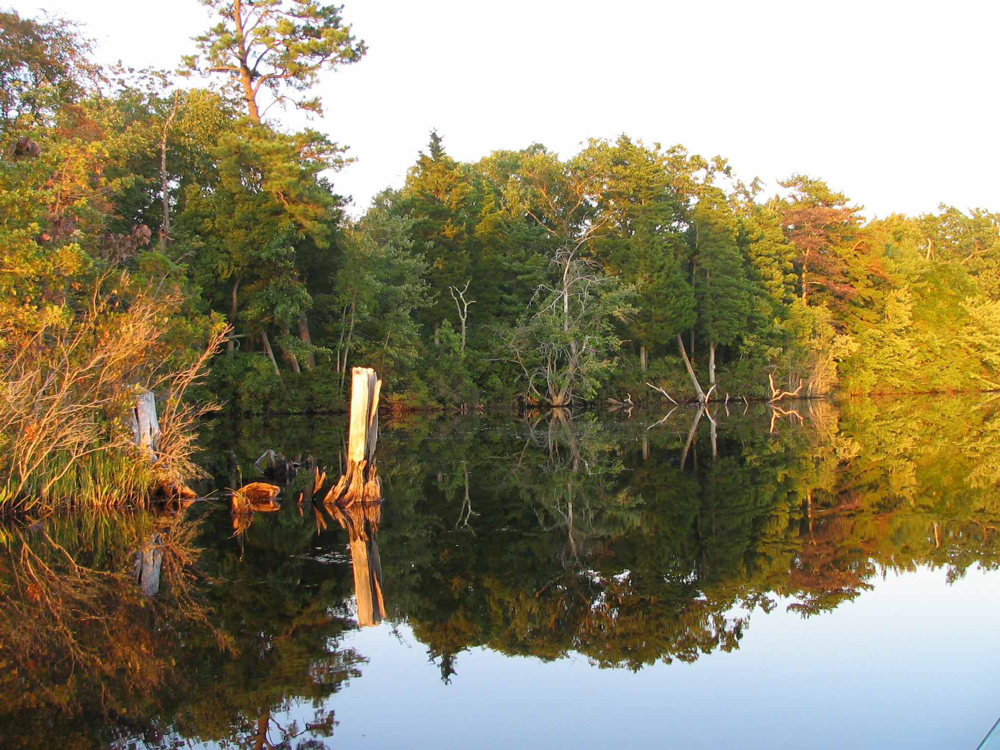
 Lake Atsion in the Pine Barrens
The Pine Barrens, also known as the Pinelands, is a heavily forested area of coastal plain stretching across southern New Jersey. The name "pine barrens" refers to the area's sandy, acidic, nutrient-poor soil, to which the crops originally imported by European settlers didn't take well. These uncommon conditions enable the Pine Barrens to support a unique and diverse spectrum of plant life, including orchids and carnivorous plants. The area is also notable for its populations of rare pygmy Pitch Pines and other plant species that depend on the frequent fires of the Pine Barrens to reproduce. The sand that composes much of the area's soil is referred to by the locals as sugar sand.
Despite its proximity to Philadelphia and New York City, and the fact that the Garden State Parkway and Atlantic City Expressway run through it, the Pine Barrens remains largely rural and undeveloped. The Pine Barrens also helps recharge the 17 trillion gallon Kirkwood-Cohansey aquifer containing some of the purest water in the United States.[1][2] As a result of all these factors, 1.1 million acres (4,500 km²) of the Pine Barrens were designated the Pinelands National Reserve (the nation's first National Reserve) in 1978, and it was designated a United Nations International Biosphere Reserve in 1988. Development in the Pinelands National Reserve is strictly controlled by an independent state/federal agency called the New Jersey Pinelands Commission. The Pinelands Reserve contains the Wharton, Brendan T. Byrne (formerly Lebanon), and Bass River state forests.
Author John McPhee wrote one of his early books, The Pine Barrens, on the history and ecology of the region in 1967.
Contents
History
During colonial times, the Pine Barrens was home to various industries. Bog iron was mined from bogs, streams, and waterways, and was worked in furnaces at Batsto, Lake Atsion, Ferrago, Hanover, and several other locations. Iron from these early furnaces was instrumental in supplying the American military with weapons and camp tools during the American Revolution and the War of 1812 and the Second Barbary War. For example, Commodore Stephen Decatur, Jr. sailed to Algiers armed with 24-pound cannons that had been cast at Hanover in 1814.[3] The bog iron industry fell off in the mid-19th century when iron ore could be mined more cheaply in Pennsylvania. Other industries such as paper mills, sawmills, and gristmills rose and fell throughout the years. Smaller industries such as charcoal-making and glassmaking also were attempted and met with varying degrees of success. Over time, however, the forest reclaimed almost all traces of the Pine Barrens' industrial past. Ghost towns—remnants of these industries—can still be found at various locations, and one, Batsto Village, has been restored to its mid-19th century state.
The Pine Barrens were home to the pseudonymous Kallikaks, a poor, backwoods family who were held up as a case study in genetic inferiority by eugenicists in the early 20th century. Today, it is understood that the facts in the Kallikaks study were misrepresented.[4] For years, residents of the area were called "Pineys", by outsiders, as a derogatory term. However, today, many Pinelands residents are proud of both the name and the land on which they live.[5]
On July 12, 1928, Mexican aviator and national hero Emilio Carranza crashed and was killed in the Pinelands while returning from a historic goodwill flight from Mexico City to the United States. Flying back from Long Island, he encountered a thunderstorm and crashed in Burlington County. A 12 ft (3.6 m) monument identifies the location of the crash.
Efforts to preserve the Pine Barrens
Despite rapid urbanization of its surrounding land, the Pine Barrens remained largely untouched because its sandy soil was unsuitable for growing most crops, and its iron and charcoal deposits couldn't compete with more readily accessible deposits elsewhere. In 1969, the Pine Barrens averaged a density of 15 people per square mile, compared with 1000 people per square mile in the lands bordering it. There were concerns for the possible destruction of the Pine Barrens by urban sprawl. Amid those concerns was a plan for the construction of a massive jetport and planned city in the Pine Barrens to alleviate congestion in other major airports. The plan was made more attractive by the cheap cost of land and lower incidence of fog in the area.[6]
The New Jersey Pinelands National Reserve, the country's first National Reserve, was created by Congress under the National Parks and Recreation Act of 1978. The New Jersey Pinelands National Reserve contains approximately 1,100,000 acres (4,500 km2) of land, and occupies 22% of New Jersey's land area. The Pinelands National Reserve was created from the land of seven New Jersey counties. The reserve contains Wharton State Forest, Brendan T. Byrne State Forest and Bass River State Forest. The Pinelands was designated a U.S. Biosphere Reserve by UNESCO in 1983 and an International Biosphere Reserve in 1988.[7] Following many years of work to preserve the Pine Barrens and educate visitors, Howard P. Boyd and his wife continue to live within the Protection Area of the Pinelands National Reserve.[8]
Jersey Devil
Main article: Jersey DevilThe Pine Barrens gave rise to the legend of, and are well known mostly because of the Jersey Devil, said to have been born to a local woman named Mrs. Leeds[9] in an area known as "Leeds Point" in 1735. It was said that he was her 13th child and that being an unlucky number he was cursed. Another story says that it was born a hideous monster which attacked the mother and nurses, before flying up and out the chimney and disappearing into the Barrens. Most alleged sightings of the legendary Devil have occurred in or near the Pine Barrens.
Plants and animals
The Pine Barrens comprise a major part of the Atlantic coastal pine barrens ecoregion. The forest communities are strongly influenced by fire, varying from dwarf pine forests less than 4 feet (120 cm) tall where fires are frequent, to pine forests, to oak forests where fires are rare. Dark swamps of Atlantic white cedar grow along the waterways.
The Pine Barrens are home to at least 39 species of mammals, 300+ species of bird, 59 reptile and amphibian species, and 91 fish species.[10] At least 43 species are considered threatened and endangered by the NJ Division of Fish and Wildlife,[11] including the rare eastern timber rattlesnakes (Crotalus horridus) and bald eagles.[12]
Believed to have been extirpated from the state by 1970 due to destruction of its territory and human encroachment, the bobcat gained legal protection in 1972 being classified as a game species with a closed season and in 1991 it was added to the list of endangered species in New Jersey. Reintroduction of the species occurred between 1978 to 1982 when 24 bobcats from Maine were released into the northern portion of the state where, since 1996, they are being monitored by biologists with the aid of GPS transmitters in order to determine habitat ranges and preferences.[13]
In addition, a scent post survey in 1995 proved bobcat presence in 4 northern counties and there have been reliable sightings of the bobcat in 9 additional (mostly southern) counties, including those encompassing large swaths of the Pine Barrens and those counties skirting it, namely; Atlantic, Burlington, Cape May, Cumberland, Ocean, and Salem counties.[14]Status
The only industries that still thrive in the Pine Barrens are related to agriculture and tourism. The Pine Barrens is the reason New Jersey grows the third-highest number of cranberries in the country, mostly attributed to the areas around Chatsworth, including Whitesbog which is north of Chatsworth. The first cultivated blueberries were developed in the Pine Barrens in 1916 through the work of Elizabeth White of Whitesbog, and blueberry farms are now almost as common as cranberry bogs. Most blueberry farms are found in and around the town of Hammonton. The Pine Barrens are also at risk from increasing development and suburbanization of the area. A threatened species of frog,[citation needed] the Pine Barrens Tree Frog, has a disjunct population there.
Forest fires
 The 2007 forest fire viewed from Barnegat Light
In the Pine Barrens, forest fire has been a common occurrence ever since it was first inhabited by people. Fire has played a major ecological role in the Pinelands, and the ecotypes "suggest that short fire intervals may have been typical in the Pine Plains for many centuries, or millennia."[15] Although natural fires have occurred, evidence shows that most fires in the region are of human origin.[16] The fire regime before European settlement is poorly understood,[15] although it is known that the Lenape tribes burned the woods in the spring and fall to improve plant yields and hunting conditions.[17] The Pine Barrens, with its sandy soil, did not attract a permanent agriculture population (whose main interest would have been to establish permanent boundaries for forest clearance).[16] Instead, the area's sparse population encouraged a longlasting attitude that forest fires should be set for local benefit—even on the lands of others. It was profitable for charcoal burners to set fires deliberately, in order to make the trees useless for any purpose other than charcoal making, then purchase the trees for a discount.[16]
Forest fires play an important role in regulating the growth of plants in the Pine Barrens. Frequent light fires tend to reduce the amount of undergrowth and promote the growth of mature trees. Forest fire is also a reason why the Pitch Pine is dominant in the Pine Barrens. Pitch Pines are common because of their ability to resist and recover from fire by resprouting directly through their bark (something very unusual for pines) and by serotinous pine cones which open only after having been heated by a fire.[16][18] The prevalence of forest fire allows the pitch pines to dominate over oaks, which by comparison are usually killed outright by a moderate or intense fire. High air temperatures and dry plant undergrowth contribute to the intensity of the fire. While severe fires are uncommon, severe fires at fairly frequent intervals can eliminate species that do not bear seed at an early age. Frequent killing fires keep an area covered with small sprouts.[19]
Efforts to battle forest fire attract debate over how to best preserve the Pine Barrens because of fire's danger to property and inhabitants. Preservationists argue that eliminating forest fires would cause the Pine Barrens to become dominated by oak trees. A few areas which had previously consisted of scrub and pitch pine have already become dominated by oak trees due to the lesser frequency of forest fires.[20]
Gallery
-

Atsion Lake
-

Atsion Lake
-

Atsion Lake
-

Mullica River
-

Mullica River
-

Mullica River
See also
References
- ^ Pearce, Jeremy. "Trouble in Paradise", The New York Times, June 23, 2002. Accessed September 29, 2007. "The state Pinelands Protection Act of 1979 set goals of preserving farms and undeveloped lands, discouraging piecemeal and scattered development and conserving animal and plant species on the sandy soils of the Kirkwood-Cohansey Aquifer, estimated to hold 17.7 trillion gallons of water."
- ^ "The Pine Barrens of New Jersey: A Photoessay" by Michael A. Hogan, Environment News Service, October 27, 2005. Accessed September 29, 2007. "Underlying much of the Pinelands is the Cohansey Aquifer. This formation of unconsolidated sand and gravel functions as a vast reservoir estimated to contain over 17 trillion gallons of some of the purest water in the country."
- ^ McPhee, John, The Pine Barrens, Noonday Press (1967) p. 27
- ^ Human Intelligence: The Kallikak Family
- ^ Birdsall, Bob People of the Pines (2007), Plexus Publishing, Inc., Medford, NJ.
- ^ Biography of a Place Wilderness Thrives Surrounded by City, Columbia Missourian, January 26, 1969. Accessed March 3, 2009.
- ^ New Jersey Pinelands Commission
- ^ Howard Boyd - The Piney This Tabernacle resident is the pre-eminent scholar on the Pine Barrens
- ^ Legend of the New Jersey Devil, The New Jersey Historical Society.
- ^ NJ Pine Barrens Animals
- ^ [1][dead link]
- ^ Birdsall, Bob Seasons of the Pines (2008), Island Publishing, Barnegat, NJ.
- ^ "Bobcat - March 2003 Species of the Month". http://www.state.nj.us/dep/fgw/ensp/sommarch.htm. Retrieved March 3, 2011.
- ^ "Bobcat, Felis refus" (PDF). http://www.state.nj.us/dep/fgw/ensp/pdf/end-thrtened/bobcat.pdf. Retrieved March 3, 2011.
- ^ a b Anderson, Roger Clark; James Steven Fralish, Jerry Mack Baskin (1999). Savannas, Barrens, and Rock Outcrop Plant Communities of North America. Cambridge University Press. ISBN 9780521573221.
- ^ a b c d Forman, Richard (1998). Pine Barrens: ecosystem and landscape. Rutgers University Press. ISBN 0813525934. http://books.google.com/books?id=b-scntoSJ7QC&dq=pine+barrens+forest+fire+pitch+pine+serotinous+pine+cone&source=gbs_navlinks_s. Retrieved August 31, 2010.
- ^ Stansfield, Charles (1998). A geography of New Jersey: the city in the garden. Rutgers University Press. ISBN 0813525799. http://books.google.com/books?id=FTXwgHg89W8C&dq=%22pine+barrens%22+forest+fire+lenape&source=gbs_navlinks_s. Retrieved August 31, 2010.
- ^ Dudley, Elizabeth. Forests: a fact-filled coloring book, 1990, p. 58.
- ^ Forman, Richard. Fire Effects in New Jersey's Pine Barrens by Silas Little
- ^ Peterson, Iver. "Fire in the Pine Barrens: Keeping the Oak at Bay", The New York Times, May 29, 1992. Accessed March 21, 2009.
External links
Governance
- New Jersey Pinelands Commission
- NPS National Pinelands Reserve
- Pine Barrens Education Page
- National Park Service: Partnership Wild & Scenic Rivers
History and ecology
- Birds of the Pine Barrens
- Plants of the Pine Barrens
- NJPineBarrens.com - Exploring the Ghost Towns of Southern New Jersey
- American Revolutionary War actions in the Pinelands area
Non-profit organizations and other local interests
- NJ Pinelands and Down Jersey
- Photos of Colliers Mills WMA
- Forked River Mountain Coalition
- Pine Barrens Ecology & Protection - Pinelands Preservation Alliance
- Pine Barrens Landscape and Habitat Photos
- Piney Power.com
- Batona Trail
- South Jersey Tourism Corporation
- Citizens United to Protect the Maurice River and Its Tributaries, Inc.
- Pinelands photo galleries of native flora,fauna, and landscapes
 State of New Jersey
Trenton (capital) Topics Delegations · Demographics · Economy · Elections · Geography · Government · History · Media · Municipalities · Music · People · Politics · Symbols · Transportation · Parks
Regions Atlantic Coastal Plain · Central Jersey · Delaware River Region · Delaware Valley · Gateway Region · Gold Coast · Highlands · Jersey Shore · Meadowlands · New York metro area · North Hudson · North Jersey · Pascack Valley · Piedmont · Pine Barrens · Raritan Bayshore · Ridge-and-Valley Appalachians · Southern Shore Region · Skylands Region · South Jersey · Tri‑State Region · West Hudson
Counties Major cities Atlantic City · Camden · Edison · Elizabeth · Hackensack · Jersey City · Newark · New Brunswick · Ocean City · Paterson · Trenton · Vineland
Categories:- Pine Barrens of New Jersey
- Natural history of New Jersey
- Trees of New Jersey
- Ecoregions of the United States
-


Wikimedia Foundation. 2010.