- Passaic County, New Jersey
Infobox U.S. County
county = Passaic County
state = New Jersey
map size = 100
founded =February 7 ,1837
seat = Paterson
largest city = Paterson
area_total_sq_mi =197
area_land_sq_mi =185
area_water_sq_mi =12
area percentage = 5.97%
census yr = 2000
pop = 489049
density_km2 = 1019
web = www.PassaicCountyNJ.orgPassaic County is a
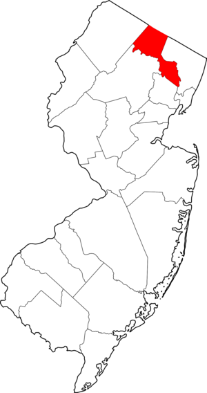
county located in theU.S. state ofNew Jersey . As of the 2000 Census, the population was 489,049. Itscounty seat is PatersonGR|6. It is part of theNew York Metropolitan Area .Passaic County was created on
February 7 ,1837 , from portions of both Bergen County and Essex County."The Story of New Jersey's Civil Boundaries: 1606-1968", John P. Snyder, Bureau of Geology and Topography; Trenton, New Jersey; 1969. p. 209.]Geography
According to the U.S. Census Bureau, the county has a total area of 197
square mile s (510km² ), of which, 185 square miles (480 km²) of it is land and 12 square miles (30 km²) of it (5.97%) is water.The highest point is any one of six areas on Bearfort Ridge in West Milford Township at approximately 1,480 ft (451 m) above sea level. The lowest elevation is approximately 30 ft (9 m) along the
Passaic River in Clifton.The southeastern, more populous half of the county is either flat near the river or mildly hilly. The northwestern section is rugged and mountainous.
Adjacent counties
*
Orange County, New York - north
*Rockland County, New York - northeast
*Bergen County, New Jersey - east
*Essex County, New Jersey - south
*Morris County, New Jersey - southwest
*Sussex County, New Jersey - westDemographics
USCensusPop
1840=16734
1850=22569
1860=29013
1870=46416
1880=68860
1890=105046
1900=155202
1910=215902
1920=259174
1930=302129
1940=309353
1950=337093
1960=406618
1970=460782
1980=447585
1990=453060
2000=489049
estimate=497093
estyear=2006
estref= [cite web
url=http://quickfacts.census.gov/qfd/states/34/34031.html
title=QuickFacts: Passaic County, New Jersey
publisher=U.S. Census Bureau
accessdate=2007-03-01]
footnote=historical census data source: [cite web
url=http://www.wnjpin.net/OneStopCareerCenter/LaborMarketInformation/lmi01/poptrd5.htm
title=New Jersey Resident Population by County: 1880 - 1930] [cite web
url=http://fisher.lib.virginia.edu/collections/stats/histcensus/
title=Geostat Center: Historical Census Browser
publisher=University of Virginia Library
accessdate=2007-03-02] As of thecensus GR|2 of 2000, there were 489,049 people, 163,856 households, and 119,614 families residing in the county. Thepopulation density was 2,639 people per square mile (1,019/km²). There were 170,048 housing units at an average density of 918 per square mile (354/km²). The racial makeup of the county was 62.32% White, 13.22% Black or African American, 0.44% Native American, 3.69% Asian, 0.04% Pacific Islander, 16.24% from other races, and 4.05% from two or more races. 29.95% of the population were Hispanic or Latino of any race. 16.3% were of Italian, 6.8% Irish, 5.3% German and 5.2% Polish ancestry according toCensus 2000 .In 2005 Non-Hispanic whites were estimated to constitute 48.9% of Passaic County's population. This included large numbers of Egyptians. 15.3% of the population was African-American. 4.4% of the population was Asian. 33.9% of the population was Latino. The large amount of Hispanics present in Passaic County can be attributed to the fact that the majority of residents in Paterson and Passaic are Hispanic, and a substantial minority are in Clifton. Throughout the other parts of Passaic county, however, there is a relatively low number of Hispanics present. This last number represented an increase of over 15,000 in the Latino population of the county. [ [http://quickfacts.census.gov/qfd/states/34/34031.html Passaic County QuickFacts from the US Census Bureau ] ]
As of the 2000 census There were 163,856 households out of which 35.60% had children under the age of 18 living with them, 51.50% were married couples living together, 16.00% had a female householder with no husband present, and 27.00% were non-families. 22.20% of all households were made up of individuals and 9.50% had someone living alone who was 65 years of age or older. The average household size was 2.92 and the average family size was 3.42.
In the county the population was spread out with 26.10% under the age of 18, 9.30% from 18 to 24, 31.30% from 25 to 44, 21.30% from 45 to 64, and 12.10% who were 65 years of age or older. The median age was 35 years. For every 100 females there were 94.00 males. For every 100 females age 18 and over, there were 90.80 males.
The median income for a household in the county was $49,210, and the median income for a family was $56,054. Males had a median income of $38,740 versus $29,954 for females. The
per capita income for the county was $21,370. About 9.40% of families and 12.30% of the population were below thepoverty line , including 17.30% of those under age 18 and 9.20% of those age 65 or over.Law and government
In Passaic County's commission form of government, the
Board of Chosen Freeholders discharge both executive and legislative responsibilities. Seven Freeholders are elected at-large for three-year terms on a staggered basis. A Freeholder Director and Freeholder Deputy Director are elected from among the seven Freeholders at an annual reorganization meeting in January. The Freeholders select a County Administrator who, in the role of chief administrative officer, supervises the day-to-day operation of county government and its departments.Passaic County operates through six standing committees of the Board of Chosen Freeholders. They are Administration & Finance; Health, Education and Community Affairs; Public Works and Buildings & Grounds; Law & Public Safety; Human Services and Planning and Economic Development. The Freeholders also appoint individuals to departments, agencies, boards and commissions for the effective administration of county government.
As of 2008 , Passaic County's Freeholders are: [ [http://www.passaiccountynj.org/Freeholders/ 2008 Passaic County Board of Chosen Freeholders] , Passaic County, New Jersey. AccessedApril 21 ,2008 ]
*Freeholder DirectorSonia Rosado (2009, Ringwood)
*Freeholder Deputy Director [http://passaiccountynj.org/cutenews/show_news.php?subaction=showfull&id=1149812988&archive=&template=freeholders Tahesha L. Way] (2009, Wayne)
*Terry Duffy (2010, West Milford)
*Elease Evans (2008, Paterson, not seeking re-election)
*James Gallagher (2009, Paterson)
*Bruce James (2008, Clifton)
*Pat Lepore (2010, West Paterson)Currently, all seven of Passaic County's Freeholders are Democrats. The party has been the majority party on the Board of Chosen Freeholders since 1998, when current freeholder Jim Gallagher and former freeholder Lois Cuccinello won two of the three seats up for election that year. Two years prior, the Republicans held an 7-0 majority, but those wins combined with the wins of
Georgia Scott andPeter Eagler in the 1996 elections gave the Democrats a narrow majority of 4-3. That majority became 5-2 in 2000, when Sonia Rosado took the seat of incumbentScott Rumana , and became an absolute majority in 2004 when Terry Duffy and Pat Lepore were elected to replace multi-term incumbent Walter Porter and his running mate Michael Mecca.Four federal
Congressional District s cover the county, with most of the northern portion of the county inNew Jersey's 5th congressional district , represented byScott Garrett (R) and most of the southern portion of the county inNew Jersey's 8th congressional district , represented byBill Pascrell (D). The borough of Hawthorne is inNew Jersey's 9th congressional district , represented bySteve Rothman (D), and a portion of the borough of Bloomingdale is inNew Jersey's 11th congressional district , represented byRodney Frelinghuysen (R).Politics
In the 2004 U.S. Presidential election,
John Kerry carried the county by a 11.5% margin overGeorge W. Bush , with Kerry carrying the state by 6.7% over Bush. [ [http://www.njvoterinfo.org/2004presNJ.htm New Jersey Presidential Election Returns by County 2004] ,Eagleton Institute of Politics atRutgers University . AccessedAugust 31 ,2008 .]Municipalities
*Bloomingdale (borough)
**Macopin (community)
*Clifton (city)
*Haledon (borough)
*Hawthorne (borough)
*Little Falls (township)
*North Haledon (borough)
*Passaic (city)
*Paterson (city)
*Pompton Lakes (borough)
*Prospect Park (borough)
*Ringwood (borough)
*Totowa (borough)
*Wanaque (borough)
**Haskell (community)
*Wayne (township)
**Packanack Lake (community)
**Pines Lake (community)
**Preakness (community)
*West Milford (township)
**Hewitt (community)
**Newfoundland (community)
**Oak Ridge (community)
*West Paterson (borough)Transportation
New Jersey Transit 's Main Line serves the eastern part of Passaic County. Numerous New Jersey Transit bus routes serve Passaic County as well.The major highways that travel through Passaic County are
Interstate 287 ,Interstate 80 ,US Route 202 ,US Route 46 , Route 23, Route 21, Route 20, Route 19, Route 4, Route 3, and theGarden State Parkway .Education
*
Passaic County Community College , founded in 1971, serves students from Passaic County at campuses in Paterson, Wanaque and Wayne.
*William Paterson University is a public university located in Wayne. As of Fall 2005, there are 9,110 undergraduate students and 1,860 graduate students enrolled in the university.
*Montclair State University is a public university located in Montclair, Little Falls and Clifton. As of Fall 2004, there are about 9,600 full-time and 2,200 part-time undergraduate and 3,800 graduate students.Points of interest
*
Garret Mountain Reservation in West Paterson
*Great Falls State Park in Paterson
*High Mountain Park Preserve in Wayne
*Rogers Locomotive and Machine Works in Paterson
*Skylands , theNew Jersey State Botanical Garden
*Yogi Berra Stadium in Little Falls
*Ringwood Manor State Park in Ringwood
*Long Pond Iron Works inWest Milford, New Jersey References
External links
* [http://www.PassaicCountyNJ.org Passaic County web site]

Wikimedia Foundation. 2010.