- New Jersey Route 20
-
Route 20
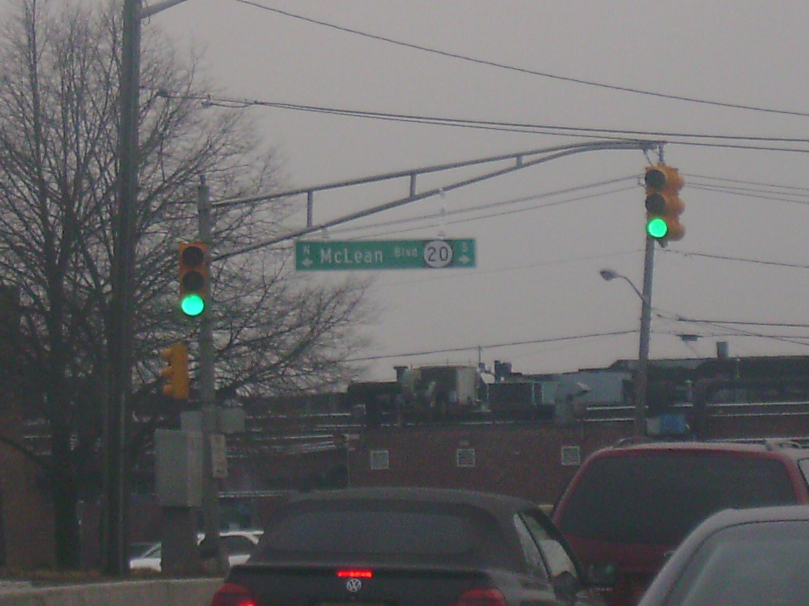
McLean Boulevard 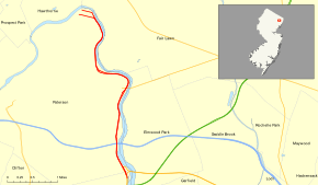
Route information Maintained by NJDOT and Passaic County Length: 4.15 mi[1] (6.68 km) Existed: 1953 – present Major junctions South end:  US 46 in Clifton
 I-80 in Paterson
 Route 4 in Paterson
North end:  CR 504 in Paterson
Highway system New Jersey State Highway Routes
Interstate and US←  Route 19
Route 21  →
→Route 20, known locally as McLean Boulevard, is a state highway that runs 4.15 miles (6.68 km) in New Jersey, United States. It runs along the east side of Paterson, Passaic County, following the west bank of the Passaic River between U.S. Route 46 and River Street (County Route 504), at which point County Route 504 begins. It is a four- to six-lane divided highway most of its length that runs through residential and commercial areas of Paterson, intersecting with Interstate 80 and Route 4 at interchanges. The northernmost part of the route is a county-maintained one-way pair that follows 1st and 2nd Avenues.
Contents
Route description
Route 20 begins at an interchange with U.S. Route 46 and County Route 630 (Crooks Avenue) just north of the Garden State Parkway on the border of Clifton and Paterson. The road follows the bend of the Passaic River directly north of Dundee Lake, heading to the north into Paterson as McLean Boulevard, a four-lane divided highway with a 45 mph (72 km/h) speed limit.[1] The route runs in between the Passaic River to the east and two large cemeteries to the west before coming to an interchange with Interstate 80 and Market Street. Past Interstate 80, Route 20 becomes a six-lane divided highway that heads through a mix of residential and commercial areas.[1][2]
The next interchange along the route is for Route 4 (Broadway), with access to both eastbound Route 4 and westbound Broadway from both directions.[1] The road continues further north as a four-lane divided highway with a speed limit of 35 mph (56 km/h), heading through more urbanized areas of Paterson. It crosses County Route 651 (East 33rd Street/Morlot Avenue), which crosses the Passaic River to become County Route 78 (Morlot Avenue) in Bergen County.[1][2]
Route 20 continues to follow the Passaic River as a 45 mph (72 km/h) road through commercial areas, featuring an intersection with County Route 652 (5th Avenue). Past this intersection, the route proceeds through urban areas, turning west and splitting into a one-way pair. Here, the route becomes county maintained, with the northbound direction following 1st Avenue and the southbound direction following 2nd Avenue before coming to an end at County Route 504 (River Street).[1][2]
History
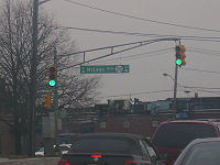 Overhead sign for Route 20.
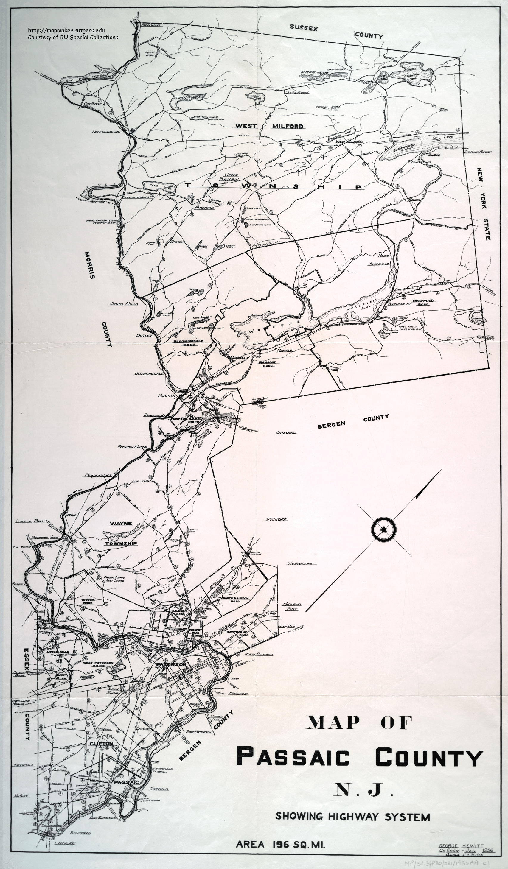
The present-day routing of Route 20 north of Market Street was legislated in 1927 as part of Route 3, which was to run from the New York border at Greenwood Lake to Secaucus.[3][4] In addition, the present day routing south of Route 4 was also legislated as part of that route, which was to run from the George Washington Bridge to Cape May.[3] In 1929, the western terminus of Route 3 was moved to Paterson as Route S4B (now Route 208) was planned to replace the alignment of Route 3 from Paterson to the New York border.[5] McLean Boulevard through Paterson was built by the 1930s.[6] In the 1953 New Jersey state highway renumbering, Route 20 was legislated to follow the former alignment of Route 3 between Paterson and East Rutherford as Route 3 was moved to the Route S3 freeway that was built between East Rutherford and Clifton.[7]
Another freeway routing of Route 20 was planned in 1959.[8] This road, which was to be a six-lane freeway called the Paterson Peripheral, was to run from Clifton north to the existing Route 20 in downtown Paterson.[9] This road was completed between the Garden State Parkway and Valley Road by 1969 and north to Interstate 80 in 1971.[9][10] Upon completion, this road received the Route 20 designation.[9] In 1972, the state took over maintenance of the Paterson Plank Road from Route 3 to Route 17 in East Rutherford and made it a part of the route.[11] As these three sections of Route 20 were not connected, they received three different route designations by the 1990s. The freeway section of Route 20 from the Garden State Parkway to Interstate 80 was designated Route 19, the section between Route 3 and Route 17 was designated Route 120, and the Route 20 designation was retained along McLean Boulevard through Paterson.[12][13] The unfinished section of Route 20 that was to connect McLean Boulevard to Paterson Plank Road was built as a northern extension of the Route 21 freeway in 2000.[14][15]
Major intersections
The entire route is in Passaic County.
Location Mile[1] Destinations Notes Clifton 0.00 US 46 west – CliftonInterchange; southbound exit and northbound entrance 0.08 
 US 46 east / G.S. Pkwy. south / CR 630 (Crooks Avenue)
Interchange; southbound exit and northbound entrance Paterson 0.70 I-80 – Delaware Water Gap, Elmwood ParkInterchange 0.81  To CR 56 (Market Street) – Elmwood Park, Paterson
Interchange 1.86 Route 4 east – New YorkInterchange; no northbound entrance 1.92 Broadway – Paterson 2.63 
 CR 651 (33rd Street/Morlot Avenue) to CR 78 – Fair Lawn
3.35  CR 652 (5th Avenue)
3.45  To CR 76 (Fair Lawn Avenue Bridge)
3.97 Maple Avenue – Glen Rock, Ridgewood 4.15 CR 504 (River Street)1.000 mi = 1.609 km; 1.000 km = 0.621 mi See also
 U.S. Roads portal
 New Jersey portal
References
- ^ a b c d e f g "Route 20 straight line diagram". New Jersey Department of Transportation. http://www.state.nj.us/transportation/refdata/sldiag/00000020__-.pdf. Retrieved 2009-03-11.
- ^ a b c Google, Inc. Google Maps – overview of New Jersey Route 20 (Map). Cartography by Google, Inc. http://maps.google.com/maps?f=d&source=s_d&saddr=route+46+and+roosevelt+avenue+elmwood+park,+nj&daddr=first+avenue+and+river+street+paterson,+nj&geocode=&hl=en&mra=ls&rtol=1&sll=40.892802,-74.123769&sspn=0.007218,0.013733&ie=UTF8&t=h&z=13. Retrieved 2009-03-11.
- ^ a b State of New Jersey, Laws of 1927, Chapter 319.
- ^ Williams, Jimmy and Sharon. "1927 New Jersey Road Map". 1920s New Jersey Highways. http://www.jimmyandsharonwilliams.com/njroads/1920s/images/1927_routes.gif. Retrieved 2008-10-08.
- ^ State of New Jersey, Laws of 1929, Chapter 126.
- ^ Rutgers University Cartography Services (1936). Map of Passaic County N.J. (Map). http://mapmaker.rutgers.edu/PASSAIC_COUNTY/PassaicCo1936.gif. Retrieved 2009-03-28.
- ^ 1953 renumbering. New Jersey Department of Highways. http://en.wikisource.org/wiki/1953_New_Jersey_state_highway_renumbering. Retrieved July 31, 2009
- ^ State of New Jersey, Laws of 1959, Chapter 4.
- ^ a b c Anderson, Steve. "NJ 19 Freeway". Eastern Roads. http://www.nycroads.com/roads/NJ-19/. Retrieved 2009-03-11.
- ^ Chevron Oil Company (1969). Map of New Jersey (Map). Cartography by H.M. Gousha.
- ^ State of New Jersey, Laws of 1972, Chapter 209.
- ^ State Farm Insurance (1983). State Farm Road Atlas (Map). Cartography by Rand McNally.
- ^ Rand McNally (1996). United States-Canada-Mexico Road Atlas (Map).
- ^ Gohlke, Josh (December 27, 2000). "Route 21's Final Leg Is Opened Officially". The Bergen Record.
- ^ Page, Jeffrey (December 21, 2000). "Missing Link Is Finished After 28 Years". The Bergen Record.
External links
Categories:- State highways in New Jersey
- Transportation in Passaic County, New Jersey
- Limited access New Jersey state routes


Wikimedia Foundation. 2010.