- Barnegat Light, New Jersey
Infobox Settlement
official_name = Barnegat Light, New Jersey
settlement_type = Borough
nickname =
motto =
imagesize =
image_caption =
image_
imagesize =
image_caption =
image_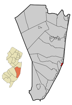
mapsize = 250x200px
map_caption = Map of Barnegat Light in Ocean County. Inset: Location of Ocean County highlighted in the State of New Jersey.
mapsize1 = 250x200px
map_caption1 = Census Bureau map of Barnegat Light, New Jerseysubdivision_type = Country
subdivision_name =United States
subdivision_type1 = State
subdivision_name1 =New Jersey
subdivision_type2 = County
subdivision_name2 = Ocean
government_footnotes =
government_type =Borough (New Jersey)
leader_title =Mayor
leader_name = Kirk O. Larson, Sr.
leader_title1 =
leader_name1 =
established_title = Incorporated
established_date =March 29 ,1904 as "Barnegat City"
established_title = Renamed
established_date =November 2 ,1948 as "Barnegat Light"unit_pref = Imperial
area_footnotes =
area_magnitude =
area_total_km2 = 2.2
area_land_km2 = 1.9
area_water_km2 = 0.3
area_total_sq_mi = 0.9
area_land_sq_mi = 0.7
area_water_sq_mi = 0.1population_as_of = 2006
population_footnotes =
population_total = 833
population_density_km2 = 408.0
population_density_sq_mi = 1056.8timezone = Eastern (EST)
utc_offset = -5
timezone_DST = EDT
utc_offset_DST = -4
elevation_footnotes = [Gnis|885148|Borough of Barnegat Light,Geographic Names Information System . AccessedJanuary 4 ,2008 .]
elevation_m = 1
elevation_ft = 3
latd = 39 |latm = 45 |lats = 07 |latNS = N
longd = 74 |longm = 06 |longs = 38 |longEW = Wpostal_code_type =
ZIP code
postal_code = 08006
area_code = 609
blank_name = FIPS code
blank_info = 34-03130GR|2 [ [http://mcdc2.missouri.edu/webrepts/commoncodes/ccc_nj.html A Cure for the Common Codes: New Jersey] , Missouri Census Data Center. AccessedJuly 14 ,2008 .]
blank1_name = GNIS feature ID
blank1_info = 0885148GR|3
website = http://www.barnlight.com
footnotes =Barnegat Light is a Borough in Ocean County,
New Jersey ,United States . As of theUnited States 2000 Census , the borough population was 764. The borough borders theAtlantic Ocean onLong Beach Island and is home toBarnegat Lighthouse .Barnegat Light was formed as a Borough by the
New Jersey Legislature onNovember 2 ,1948 , to replace Barnegat City borough, which in turn had been created onMarch 29 ,1904 , from portions of Long Beach Township."The Story of New Jersey's Civil Boundaries: 1606-1968", John P. Snyder, Bureau of Geology and Topography; Trenton, New Jersey; 1969. p. 194.]Geography
Barnegat Light is located at coor dms|39|45|7|N|74|6|39|W|city (39.751960, -74.110745).GR|1
According to the
United States Census Bureau , the borough has a total area of 0.9 square miles (2.2 km²), of which, 0.7 square miles (1.9 km²) of it is land and 0.1 square miles (0.4 km²) of it (16.28%) is water.History
Early history
The area surrounding the
Barnegat Bay andBarnegat Inlet were described byHenry Hudson , in 1609, as "...a great lake of water, as we could judge it to be ... The mouth of the lake hath many shoals, and the sea breaketh on them as it is cast out of the mouth of it." The name of the existing town was obtained from the Bay and Inlet, which were originally named in 1614 "Barendegat," or "Inlet of the Breakers," by Dutch settlers, referring to the waterway's turbulent channel. [Lloyd, p. 42.]On October 26, 1782, a Belgian cutter traveling southward became stranded near the inlet. The ship was noticed by Captain Andrew Steelman, whom recruited local men to unload the cargo. While at rest on the beach, the crews were attacked by Captain John Bacon, who was affiliated with the Loyalists. Almost all of Steelman's men were murdered in what became known as the Barnegat Light Massacre. [Karch, p. 16.]
In 1795, the first permanent settler - Caleb Parker -- arrived to the Barnegat Inlet area. By the 19th century, the northern stretches of Long Beach Island were known among early settlers for the wildlife and subsequent hunting, as well as a tourist destination for vacationing farmers and campers. In 1814, portions of the lowlands and beaches were purchased by settlers Bart and Ruth Slaight, who built a small house and later, in 1825, a larger home to accommodate boarders. The boardinghouse was later sold to Jacob Herring, which prompted the structure to become known as the Herring House. The building lodged many of the visiting hunters, who primarily came from
New York City andPhiladelphia . Nearly a decade later, in 1834, Slaight sold five acres of land to the United States Federal Government under the stipulation that no stores or taverns may be built, nor could the lands be used for cattle.The first lighthouse tower was built in 1835 to coincide with the increased economic dependence on the inlet.
Whaling had been permitted in the area in 1678,timber was often freighted through fromsawmill s on the mainland, andCranberry Inlet (opened in 1750 to provide a shortcut for cargo ships) had recently been closed.Brownsville
In 1855, John M. Brown bought much of the land that makes up present-day Barnegat Light. This purchase included the acquisition of Herring House, which was renamed Ashley House. The first official name of the community thus became Brownsville. During this time, a "house of refuge" was built to provide an unmanned shelter for shipwreck victims. Despite several attempts at constructing jetties, the powerful tides caused considerable erosion of the beaches and threatened both Barnegat Lighthouse and later the Oceanic Hotel. The lighthouse collapsed into the sea in 1857 and a replacement lighthouse (already under construction in 1857) was completed in 1859.
The Brown family left the island after John Brown's son drowned at sea. [Karch, p. 6.] The Brown family's land was sold at auction in 1869, and in 1874, Ashley House was sold to Charles Martin. The
United States Life-Saving Service built Station #17 in the areacirca 1872. Around approximately 1875, the general store and post office were constructed near the intersection of 4th Street and Central Avenue. The general store was originally run by Lucrecia Buttersworth and provided limited supplies -- largely due to the difficulty with transporting merchandise to the shop. The general store was purchased by the Applegate family in 1919 -- the family of a lighthouse keeper who was also a net fisherman.Barnegat City
In 1881, the Barnegat City Improvement Company was formed by Benjamin Franklin Archer, prompting the name of the community to unofficially become Barnegat City. Adding "city" helped the new resort town capitalize on the success of Atlantic City. [Lloyd, pgs. 41, 47.] The plan succeeded, as the city became a popular tourist destination -- primarily for vacationers from
New York City , who would travel by train to Toms River and then travel by boat to Barnegat City. The SS "Hesse" -- a ship chartered by thePennsylvania Railroad -- began providing transport in to Barnegat City for passengers largely originating from New York City and Trenton. This ship was later replaced by the "Connetquot". The Oceanic Hotel was built to meet the increasing lodging demands of the tourism industry, beginning construction in 1881 and completing construction in 1882. The hotel would later be relocated in response to encroaching waters, so-as to avoid a similar fate as the firstBarnegat Lighthouse .The Ashley House was sold to John Warner Kinsey in 1882, who renamed the building as the eponymous Kinsey Hotel. Kinsey would later move to nearby Harvey Cedars, abandoning the hotel. A new hotel, the Sans Souci, was built in 1883 with the intention of attracting winter sportsmen. A fourth hotel, The Social, opened to boarders in 1884. Between 1884 and 1886, a direct railroad connection was completed to increase the city's tourism capabilities. The first train reached Barnegat City on June 28, 1886. A large keeper's house was completed in 1889 by the Federal Lighthouse Bureau to house the three keepers and their families. In 1899, Benjamin Archer sold the Sans Souci, which was subsequently renamed the Sunset Hotel. During the
Spanish-American War , theUnited States Life-Saving Service kept watch for enemy ships and a signal house was constructed offshore; but the signal house was complete shortly after the peace was declared.Barnegat City became of part of Long Beach Township after the township's establishment in 1899. Five years later, in 1904, the city declared itself an independent borough. At this time, much of the northern area of Long Beach Island was undeveloped, causing citizens to feel separated from the rest of the township's communities.
In 1914, the Oceanic Hotel closed and the Sunset Hotel was purchased by John Barber. Also in the same year, an automobile bridge was opened further south, improving access between the island and the mainland. In 1920, Ketzel's Bar was opened on West 7th Street by Paul Ketzel. This location provided rooms to local fisherman and was the prominent location in the city for nighttime entertainment. The bar was later purchased by "Ma" Kubel, resulting in the new name Kubel's Bar -- a restaurant which continues to exist today. The bar began serving meals in a dining room addition and was known for its local parties featuring Norwegian dancing.
Also in 1920, a severe winter storm destroyed most of the Oceanic Hotel as well as a large portion of the beaches -- eroding the shore up to the base of the lighthouse and prompting the abandonment and removal of the keeper's house by the
United States Lighthouse Service . The destruction of the hotel and continued erosion of the beaches caused the resort to become less popular -- ultimately resulting in the discontinuation of train service to the city between 1923 and 1926. Barnegat City returned to its relatively secluded environment that it had experienced in its earlier days.The city's
fishery economy improved beginning with a fishery opened by Captain Dick Myers in 1920, whom the next year purchased 33 acres between West 7th Street and the bay. In 1927, severalScandinavia n fisherman united to form the Independent Fishery. During this period,Gillnet ting declined in popularity, but it would later gain a comeback in the 1950s. Also in the 1950s, dragger fishing was ended andtilefish ing began.The Scandinavian fisherman founded the Independent Dock, which is now known as Viking Village and, today, provides a combined shopping and industrial establishment with both handcrafted goods and fresh seafood. Catches typically consist of
scallop s,tuna ,swordfish , tilefish,weakfish ,monkfish ,bluefish ,shad ,dogfish , and various other types of in-shore fish. In the 1960s and 1970s, foreign trawlers were permitted to fish in the area. This has resulted in nearly all of thecod to have been fished out of the area. [cite web | url=http://www.fishingnj.org/bizzvik.htm | title=New Jersey Fishing: Viking Village, Inc. | accessdate=May 06 | accessyear=2007] Of particular interest is that the scallop boat "Lindsay L", docked at Viking Village, was used in the movie "The Perfect Storm" [ [http://www.nj.com/munchmobile/ledger/index.ssf?/munchmobile/ledger/stories/njshore_05.html Munchmobile: Jersey Shore] , accessedMay 06 ,2007 ]A series of disasters in the area occurred during the 1930s, beginning with the destruction of the Sunset Hotel by fire in June 1932. The next year, the Airship "USS Akron" crashed in the sea near Barnegat Light. Two years later, in 1935, the railroad bridge located to the south washed out, resulting in the complete discontinuation of railroad service to all of Long Beach Island.
Barnegat Light
In 1948, Barnegat City was renamed as Barnegat Light. The motivations for this renaming were both to honor the legacy of the lighthouse (which was decommissioned four years earlier) and also to disambiguate itself from nearby Barnegat Township. [cite web | url=http://www.lbi.net/communities/Barnegat_Light/history.asp | title=Barnegat Light History | accessdate=February 12 | accessyear=2007] In 1950, the post office moved from the Applegate general store's location to a new location on 18th Street. The building it replaced had itself been a general store and a gas station, both owned by Jens Jensen in 1920; whom had given it to John Englesen in 1940 as a trade for a house on 19th Street. The post office remained at this location until its current location on 10th Street was opened. The site of the first post office, at the general store on 4th Street, remains today as the Inlet Deli.
The continued threat of storms such as the
Ash Wednesday Storm of 1962 reinforced concerns about the stability of Barnegat Light's beaches. The construction of the existingjetty in the 1990s added a significant amount of land to the town, much of which was designated as parkland and now includes a bird sanctuary. The jetty has provided stabilization to the shoreline along the inlet, but requires frequentdredging . In addition to the lighthouse, the town continues to maintain aUnited States Coast Guard station, reflecting the continued presence of the former United States Life-Saving Service. In line with the town's history, its most prominent industries continue to be tourism and fishing.Demographics
USCensusPop
1930=144
1940=225
1950=227
1960=287
1970=554
1980=619
1990=675
2000=764
estimate= 833
estyear=2006
estref= [http://factfinder.census.gov/servlet/SAFFPopulation?_event=Search&geo_id=16000US3437110&_geoContext=01000US%7C04000US34%7C16000US3437110&_street=&_county=barnegat+light&_cityTown=barnegat+light&_state=04000US34&_zip=&_lang=en&_sse=on&ActiveGeoDiv=geoSelect&_useEV=&pctxt=fph&pgsl=160&_submenuId=population_0&ds_name=null&_ci_nbr=null&qr_name=null®=null%3Anull&_keyword=&_industry= Census data for Barnegat Light borough] ,United States Census Bureau . AccessedAugust 14 ,2007 .]
footnote=Population 1930 - 1990. [ [http://www.wnjpin.net/OneStopCareerCenter/LaborMarketInformation/lmi01/poptrd6.htm New Jersey Resident Population by Municipality: 1930 - 1990] , Workforce New Jersey Public Information Network. AccessedMarch 1 ,2007 .] As of thecensus GR|2 of 2000, there were 764 people, 371 households, and 230 families residing in the borough. Thepopulation density was 1,056.8 people per square mile (409.7/km²). There were 1,207 housing units at an average density of 1,669.6/sq mi (647.3/km²). The racial makeup of the borough was 98.30% White, 0.52% African American, 0.26% Asian, 0.26% Pacific Islander, 0.39% from other races, and 0.26% from two or more races. Hispanic or Latino of any race were 0.79% of the population.There were 371 households out of which 15.9% had children under the age of 18 living with them, 55.0% were married couples living together, 3.2% had a female householder with no husband present, and 38.0% were non-families. 34.8% of all households were made up of individuals and 19.7% had someone living alone who was 65 years of age or older. The average household size was 2.05 and the average family size was 2.60.
In the borough the population was spread out with 14.4% under the age of 18, 4.5% from 18 to 24, 17.4% from 25 to 44, 29.5% from 45 to 64, and 34.3% who were 65 years of age or older. The median age was 55 years. For every 100 females there were 103.7 males. For every 100 females age 18 and over, there were 99.4 males.
The median income for a household in the borough was $52,361, and the median income for a family was $66,406. Males had a median income of $52,917 versus $45,000 for females. The
per capita income for the borough was $34,599. About 2.6% of families and 4.7% of the population were below thepoverty line , including 13.5% of those under age 18 and 1.8% of those age 65 or over.Government
Local government
Barnegat Light is governed under the Borough form of New Jersey municipal government. The government consists of a Mayor and a Borough Council comprising six council members, with all positions elected at large. A Mayor is elected directly by the voters to a four-year term of office. The Borough Council consists of six members elected to serve three-year terms on a staggered basis, with two seats coming up for election each year. ["2005 New Jersey Legislative District Data Book",
Rutgers University Edward J. Bloustein School of Planning and Public Policy , April 2005, p. 49.]The
Mayor of Barnegat Light is Kirk O. Larson, Sr. (R, 2010). Members of the Borough Council are Council President Michael W. Spark (R, 2009), David E. Bossi (R, 2008), Frank F. Mikuletzky (R, 2010), James E. Morrison (R, 2010), Dorothy Reynolds (R, 2008) and George M. Warr (R, 2008). [ [http://www.barnlight.com/mayor.html The Mayor's Corner] , Borough of Barnegat Light. AccessedJune 15 ,2008 .] [ [http://www.oceancountyclerk.com/elelectedofficials2008.pdf#page=1 2008 Elected Officials of Ocean County] ,Ocean County, New Jersey . p. 1-2. AccessedJune 15 ,2008 .]Federal, state and county representation
Barnegat Light is in the Third Congressional District and is part of New Jersey's 9th Legislative District. [ [http://www.lwvnj.org/pubs/CG06.pdf 2006 New Jersey Citizen's Guide to Government] , New Jersey
League of Women Voters , p. 54. AccessedAugust 30 ,2006 .]Education
In 1903, the city's first and only school was built, consisting of a single room. The
one-room school closed in 1951.Fact|date=June 2008For grades K through 6, public school students attend the
Long Beach Island Consolidated School District , which serves students from Barnegat Light, Harvey Cedars, Long Beach Township, Ship Bottom and Surf City. ["2005 New Jersey Legislative District Data Book",Rutgers University Edward J. Bloustein School of Planning and Public Policy , April 2005, p. 212.] Schools in the district (with 2005-06 enrollment data from theNational Center for Education Statistics [ [http://nces.ed.gov/ccd/schoolsearch/school_list.asp?Search=1&DistrictID=3408910 Data for the Long Beach Island School District] ,National Center for Education Statistics . AccessedMarch 10 ,2008 .] ) are [http://www.lbischools.org/lbi/Jacobsen/_top Ethel Jacobsen School] in Surf City with 132 students in grades Kindergarten - 2 and [http://www.lbischools.org/lbi/LBI/_top Long Beach Island Grade School] in Ship Bottom with 135 students in grades 3 - 6.Students in public school for grades 7 through 12 attend the [http://www.srsd.net/middleschool Southern Regional Middle School] (grades 7 and 8) and
Southern Regional High School (grades 9 - 12). These schools are part of theSouthern Regional School District , which serves the five municipalities in the Long Beach Island Consolidated School District, along with students from Beach Haven, Stafford Township and Ocean Township who attend as part ofsending/receiving relationship s. [ [http://education.state.nj.us/rc/rc07/narrative/29/4950/29-4950-050.html Southern Regional High School 2007 Report Card Narrative] ,New Jersey Department of Education . AccessedMarch 10 ,2008 . "Situated in Manahawkin, the Southern Regional High School District draws from the constituent municipalities of Long Beach Township, Beach Haven, Surf City, Ship Bottom, Barnegat Light, Harvey Cedars and Stafford Township, as well as the tuition sending municipality of Ocean Township (Waretown)."] Both schools are in Manahawkin.References
ources
*Karch, Mary. "Under the Lighthouse - Memories of Barnegat City." 2004, Down The Shore Publishing
*Lloyd, John Bailey. "Eighteen Miles of History on Long Beach Island." 1994, Down The Shore Publishing and The SandPaper, Inc.External links
* [http://www.barnlight.com/ Barnegat Light website]
* [http://www.barnegatlightfire.org/ Barnegat Light Fire Company website]
* [http://www.lbischools.org Long Beach Island School District]
*NJReportCard|29|2760|0|Long Beach Island School District
* [http://nces.ed.gov/ccd/schoolsearch/school_list.asp?Search=1&DistrictID=3408910 Data for the Long Beach Island School District] ,National Center for Education Statistics
* [http://www.srsd.net/ Southern Regional School District]
* [http://www.lbimemories.com/gallery/barnegatlight/index.html Photos by Sandra Anton]
Wikimedia Foundation. 2010.