- Harvey Cedars, New Jersey
Infobox Settlement
official_name = Harvey Cedars, New Jersey
settlement_type = Borough
nickname =
motto =
imagesize =
image_caption =
image_
imagesize =
image_caption =
image_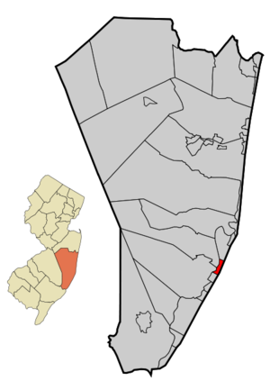
mapsize = 250x200px
map_caption = Map of Harvey Cedars in Ocean County. Inset: Location of Ocean County highlighted in the State of New Jersey.
mapsize1 = 250x200px
map_caption1 = Census Bureau map of Harvey Cedars, New Jerseysubdivision_type = Country
subdivision_name =United States
subdivision_type1 = State
subdivision_name1 =New Jersey
subdivision_type2 = County
subdivision_name2 = Ocean
government_footnotes =
government_type =Walsh Act (New Jersey)
leader_title =Mayor
leader_name = Jonathan Oldham
leader_title1 =
leader_name1 =
established_title = Incorporated
established_date =November 20 ,1894 unit_pref = Imperial
area_footnotes =
area_magnitude =
area_total_km2 = 3.1
area_land_km2 = 1.4
area_water_km2 = 1.7
area_total_sq_mi = 1.2
area_land_sq_mi = 0.5
area_water_sq_mi = 0.6population_as_of = 2006
population_footnotes =
population_total = 389
population_density_km2 = 253.7
population_density_sq_mi = 657.1timezone = Eastern (EST)
utc_offset = -5
timezone_DST = EDT
utc_offset_DST = -4
elevation_footnotes = [Gnis|885246|Borough of Harvey Cedars,Geographic Names Information System . AccessedJanuary 4 ,2008 .]
elevation_m = 2
elevation_ft = 7
latd = 39 |latm = 41 |lats = 58 |latNS = N
longd = 74 |longm = 08 |longs = 30 |longEW = Wpostal_code_type =
ZIP code
postal_code = 08008
area_code = 609
blank_name = FIPS code
blank_info = 34-30390GR|2 [ [http://mcdc2.missouri.edu/webrepts/commoncodes/ccc_nj.html A Cure for the Common Codes: New Jersey] , Missouri Census Data Center. AccessedJuly 14 ,2008 .]
blank1_name = GNIS feature ID
blank1_info = 0885246GR|3
website = http://www.harveycedars.org
footnotes =Harvey Cedars is a Borough in Ocean County,
New Jersey ,United States . As of the 2000 Census, the borough population was 359. The borough borders theAtlantic Ocean onLong Beach Island .Harvey Cedars was incorporated as a borough by an Act of the
New Jersey Legislature onDecember 15 ,1894 ) from portions of Union Township (now Barnegat Township), based on the results of a referendum held onNovember 20 ,1894 )."The Story of New Jersey's Civil Boundaries: 1606-1968", John P. Snyder, Bureau of Geology and Topography; Trenton, New Jersey; 1969. p. 202.]Geography
Harvey Cedars is located at coor dms|39|42|2|N|74|8|18|W|city (39.700679, -74.138421)GR|1.
According to the
United States Census Bureau , the borough has a total area of 1.2square mile s (3.1km² ), of which, 0.6 square miles (1.4 km²) of it is land and 0.6 square miles (1.7 km²) of it (54.62%) is water.Demographics
USCensusPop
1930=53
1940=74
1950=106
1960=134
1970=314
1980=363
1990=362
2000=359
estimate= 389
estyear=2006
estref= [http://factfinder.census.gov/servlet/SAFFPopulation?_event=Search&geo_id=06000US3401962250&_geoContext=01000US%7C04000US34%7C05000US34019%7C06000US3401962250&_street=&_county=harvey+cedars&_cityTown=harvey+cedars&_state=04000US34&_zip=&_lang=en&_sse=on&ActiveGeoDiv=geoSelect&_useEV=&pctxt=fph&pgsl=060&_submenuId=population_0&ds_name=null&_ci_nbr=null&qr_name=null®=null%3Anull&_keyword=&_industry= Census data for Harvey Cedars borough] ,United States Census Bureau . AccessedAugust 10 ,2007 .]
footnote=Population 1930 - 1990. [ [http://www.wnjpin.net/OneStopCareerCenter/LaborMarketInformation/lmi01/poptrd6.htm New Jersey Resident Population by Municipality: 1930 - 1990] , Workforce New Jersey Public Information Network. AccessedMarch 1 ,2007 .] As of thecensus GR|2 of 2000, there were 359 people, 167 households, and 112 families residing in the borough. Thepopulation density was 657.1 people per square mile (252.0/km²). There were 1,205 housing units at an average density of 2,205.6/sq mi (845.9/km²). The racial makeup of the borough was 96.94% White, 0.56% African American, 0.28% Native American, 0.28% Asian, 1.95% from other races. Hispanic or Latino of any race were 3.62% of the population.There were 167 households out of which 16.8% had children under the age of 18 living with them, 61.7% were married couples living together, 4.2% had a female householder with no husband present, and 32.9% were non-families. 29.3% of all households were made up of individuals and 15.6% had someone living alone who was 65 years of age or older. The average household size was 2.15 and the average family size was 2.61.
In the borough the population was spread out with 14.5% under the age of 18, 4.2% from 18 to 24, 22.0% from 25 to 44, 29.0% from 45 to 64, and 30.4% who were 65 years of age or older. The median age was 54 years. For every 100 females there were 102.8 males. For every 100 females age 18 and over, there were 106.0 males.
The median income for a household in the borough was $61,875, and the median income for a family was $69,722. Males had a median income of $71,042 versus $32,361 for females. The
per capita income for the borough was $36,757. About 2.6% of families and 5.1% of the population were below thepoverty line , including 5.1% of those under age 18 and 2.9% of those age 65 or over.The majority of the housing units in the borough are seasonal houses used primarily in the summer by owners who live elsewhere, bringing the summer population to approximately 2,000. The borough's quiet character and bay and ocean access make housing very expensive, with bay or oceanfront houses priced at $2 million or more.Fact|date=July 2008
Government
Local government
The Borough of Harvey Cedars has operated under the Walsh Act Commission form of New Jersey municipal government since 1923. [ [http://www.njstatelib.org/NJ_Information/Digital_Collections/MFMG/MFMGCH4.PDF The Commission Form of Municipal Government] , p. 53. Accessed
August 10 ,2007 .] The governing body is a three-member Board of Commissioners whose members are elected at-large innonpartisan elections to serve four-year terms on a concurrent basis. ["2005 New Jersey Legislative District Data Book",Rutgers University Edward J. Bloustein School of Planning and Public Policy , April 2005, p. 49.] The current terms expire onDecember 31 ,2007 for the current commissioners. Each commissioner acts as department head. The Mayor is elected by the Board from among its members and has no veto power.Members of the Harvey Cedars Board of Commissioners are: [ [http://www.harveycedars.org/HCgovernment.html Harvey Cedars Municipal Government] , Borough of Harvey Cedars. Accessed
June 15 ,2008 .] [ [http://www.oceancountyclerk.com/elelectedofficials2008.pdf#page=3 2008 Elected Officials of Ocean County] ,Ocean County, New Jersey . p. 3-4. AccessedAugust 14 ,2007 .]
*Jonathan Oldham -Mayor andCommissioner of Public Affairs and Public Safety
*Judith E. Gerkens -Commissioner of Revenue and Finance
*Michael Garofalo -Commissioner of Public Works, Parks and Public Property Federal, state and county representation
Harvey Cedars is in the Third Congressional District and is part of New Jersey's 9th Legislative District. [ [http://www.lwvnj.org/pubs/CG06.pdf 2006 New Jersey Citizen's Guide to Government] , New Jersey
League of Women Voters , p. 58. AccessedAugust 30 ,2006 .]Education
For grades K through 6, public school students attend the
Long Beach Island Consolidated School District , which serves students from Barnegat Light, Harvey Cedars, Long Beach Township, Ship Bottom and Surf City. Schools in the district (with 2005-06 enrollment data from theNational Center for Education Statistics [ [http://nces.ed.gov/ccd/schoolsearch/school_list.asp?Search=1&DistrictID=3408910 Data for the Long Beach Island School District] ,National Center for Education Statistics . AccessedMarch 10 ,2008 .] ) are [http://www.lbischools.org/lbi/Jacobsen/_top Ethel Jacobsen School] in Surf City with 132 students in grades Kindergarten - 2 and [http://www.lbischools.org/lbi/LBI/_top Long Beach Island Grade School] in Ship Bottom with 135 students in grades 3 - 6.For grades 7 through 12, public school students attend the [http://www.srsd.net/middleschool Southern Regional Middle School] (grades 7 and 8) and
Southern Regional High School (grades 9 - 12). These schools are part of theSouthern Regional School District , which serves the five municipalities in the Long Beach Island Consolidated School District, along with students from Beach Haven, Stafford Township and Ocean Township. [ [http://education.state.nj.us/rc/rc07/narrative/29/4950/29-4950-050.html Southern Regional High School 2007 Report Card Narrative] ,New Jersey Department of Education . AccessedMarch 10 ,2008 . "Situated in Manahawkin, the Southern Regional High School District draws from the constituent municipalities of Long Beach Township, Beach Haven, Surf City, Ship Bottom, Barnegat Light, Harvey Cedars and Stafford Township, as well as the tuition sending municipality of Ocean Township (Waretown)."] Both schools are in Manahawkin.References
External links
* [http://www.harveycedars.org/ Harvey Cedars website]
* [http://www.lbischools.org Long Beach Island School District]
*NJReportCard|29|2760|0|Long Beach Island School District
* [http://nces.ed.gov/ccd/schoolsearch/school_list.asp?Search=1&DistrictID=3408910 Data for the Long Beach Island School District] ,National Center for Education Statistics
* [http://www.srsd.net/ Southern Regional School District]
Wikimedia Foundation. 2010.