- Cape May County, New Jersey
-
Cape May County, New Jersey 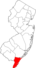
Location in the state of New Jersey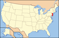
New Jersey's location in the U.S.Founded 1685 Seat Cape May Court House (Middle Township) Largest city Ocean City Area
- Total
- Land
- Water
620 sq mi (1,606 km²)
255 sq mi (660 km²)
365 sq mi (945 km²), 58.86%Population
- (2010)
- Density
97,265
382/sq mi (147.3/km²)Website www.co.cape-may.nj.us Cape May County is the southernmost county in the U.S. state of New Jersey. As of the 2010 United States Census, the population was 97,265. This county is associated with, though not officially a part of, the Delaware Valley area as well as the Ocean City Metropolitan Statistical Area. Its county seat is the Cape May Court House section in Middle Township[1].
Contents
Geography
Most of the county lies on a peninsula that juts into Delaware Bay. It is flat and coastal. Sea level is the lowest point; the highest elevation is found at three areas in Belleplain State Forest in the county's northern corner which are approximately 60 feet (18.2 m) above sea level.
According to the U.S. Census Bureau, the county has a total area of 620 square miles (1,605.8 km2). 255 square miles (660.4 km2) is land and 365 square miles (945.3 km2) (58.86%) is water.
Adjacent counties
- Atlantic County, New Jersey – north
- Cumberland County, New Jersey – northwest

Cumberland County Atlantic County Delaware Bay 
Atlantic Ocean  Cape May County, New Jersey

Atlantic Ocean National protected area
Climate
Being the southernmost point in New Jersey, Cape May has fairly mild wintertime temperatures. Contrary to that, the summertime has lower temperatures than most places in the state, making the county a popular place to escape the heat. It is in zone 7a/7b, which is the same as parts of Coastal Virginia, therefore being Humid/Temperate. It is a perfect location to grow traditional Northeastern Plants, including English Yew, Boxwoods and Sugar Maples. Because of the warmer wintertime temperatures, Hardy Palms, including Trachycarpus Fortunei (Chinese Windmill Palm) and Needle Palms, would work quite well in the landscape, these plants having survived for many years also in other parts of coastal New Jersey, from Sandy Hook to Cape May. Wine grapes also do particularly well, given the long growing season. The wine industry is growing – four vineyards and wineries operate in the county now – three more are planted and on the way. Wine grapes are quickly replacing the once vibrant lima bean industry.
According to the Köppen climate classification system, Cape May has a humid subtropical climate (Cfa) typical of New Jersey with warm summers and cold winters.
Demographics
Historical populations Census Pop. %± 1790 2,571 — 1800 3,066 19.3% 1810 3,632 18.5% 1820 4,265 17.4% 1830 4,936 15.7% 1840 5,324 7.9% 1850 6,433 20.8% 1860 7,130 10.8% 1870 8,349 17.1% 1880 9,765 17.0% 1890 11,268 15.4% 1900 13,201 17.2% 1910 19,745 49.6% 1920 19,460 −1.4% 1930 29,486 51.5% 1940 28,919 −1.9% 1950 37,131 28.4% 1960 48,555 30.8% 1970 59,554 22.7% 1980 82,266 38.1% 1990 95,089 15.6% 2000 102,326 7.6% 2010 97,265 −4.9% historical census data source:[2][3][4] As of the 2000 United States Census, there were 102,326 people in 27,354 families and 42,148 households residing in the county.[5] The population density was 401 people per square mile (155/km²).[6] There were 91,047 housing units at an average density of 357 per square mile (138/km²). The racial makeup of the county was 91.57% White, 5.06% Black or African American, 0.18% Native American, 0.65% Asian, 0.04% Pacific Islander, 1.35% from other races, and 1.16% from two or more races. 3.30% of the population were Hispanic or Latino of any race. 23.0% were of Irish, 16.7% Italian, 15.9% German, 9.4% English and 5.8% American ancestry.[7]
There were 42,148 households out of which 26.10% had children under the age of 18 living with them, 50.50% were married couples living together, 10.90% had a female householder with no husband present, and 35.10% were non-families. 30.20% of all households were made up of individuals and 14.70% had someone living alone who was 65 years of age or older. The average household size was 2.36 and the average family size was 2.94.
In the county the population was spread out with 22.30% under the age of 18, 6.40% from 18 to 24, 25.50% from 25 to 44, 25.60% from 45 to 64, and 20.20% who were 65 years of age or older. The median age was 42 years. For every 100 females there were 92.60 males. For every 100 females age 18 and over, there were 88.80 males.
The median income for a household in the county was $41,591, and the median income for a family was $51,402. Males had a median income of $39,340 versus $27,621 for females. The per capita income for the county was $24,172. About 6.40% of families and 8.60% of the population were below the poverty line, including 11.70% of those under age 18 and 7.30% of those age 65 or over.
As of 2010 the racial makeup of the population was 86.90% Non-Hispanic white, 4.69% black, 0.21% Native American, 0.86% Asian, 0.04% Pacific Islander, 0.09% Non-Hispanics of some other race, 1.41% Non-Hispanics reporting two or more races and 6.22% Hispanics or Latinos.
Government
Cape May County is governed by a Board of Chosen Freeholders consisting of five members elected at large in partisan elections to serve staggered three-year terms in office. As of 2011[update], Cape May County's freeholders (all Republicans) are:[8]
- Freeholder Director Daniel Beyel (term expires December 31, 2011)
- Freeholder Deputy Director Leonard C. Desiderio (2012)
- Ralph E. Sheets, Jr. (2011)
- M. Susan Sheppard (2013)
- Gerald M. Thornton (2013)
Politics
Though New Jersey is generally a blue state, Cape May County is a red county. In the 2008 U.S. Presidential election, John McCain carried the county by an 8.6% margin over Barack Obama, with Obama winning statewide by 15.5% over McCain.[9] Conversely, the county lies entirely within New Jersey's 1st Legislative District, which is currently represented by Senator Jeff Van Drew and Assemblymen Nelson T. Albano and Matthew W. Milam, all Democrats.[10]
Industry
The majority of Cape May County's industry is tourism, due to its beaches and location between the Delaware Bay and the Atlantic Ocean. During the summer season (which traditionally ranges from Memorial Day to Labor Day), tourists often outnumber "locals" 9 to 1. The commercial fishing industry is also important in Cape May County. In 2005 Cape May County ranked 5th nationally in commercial fishing landings and generated $68.1 million. By 2009 the total value of the catch landed at Cape May was $73.7M, good enough to be the fourth most valuable fishing port in the United States [2] Cape May County ranked 13th in the nation in pounds of fish landed with 97.5 million pounds. [3]
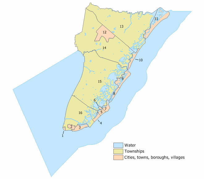
Municipalities
The following municipalities are located in Cape May County. The municipality type is listed in parentheses after the name, except where the type is included as part of the name. Census-designated places and other unincorporated communities are listed under their municipalities.
 Index map of Cape May County Municipalities (click to see index key)
- Avalon (borough)
- Cape May Point (borough)
- Cape May (city)
- Dennis Township
- Dennisville
- Ocean View
- South Dennis
- Lower Township
- Middle Township
- North Wildwood (city)
- Ocean City
- Sea Isle City
- Stone Harbor (borough)
- Upper Township
- Beesleys Point
- Marmora
- Strathmere
- Tuckahoe
- West Cape May (borough)
- West Wildwood (borough)
- Wildwood Crest (borough)
- Wildwood (city)
- Woodbine (borough)
Education
Atlantic Cape Community College, founded in 1964 with campuses in Mays Landing and Cape May Court House, serves students from both Atlantic County and Cape May County.
Rutgers, the State University of New Jersey has a partnership with Atlantic Cape Community College which offers Bachelor degree completion programs at Atlantic Cape's Mays Landing campus.
Notable residents
- Marla Adams, soap opera actress
- Mary O'Hara Alsop, Author, accomplished pianist and composer.
- Kevin Bramble, disabled ski racer, freeskier, and monoski designer and builder.
- Chris Ford, an American basketball player and coach.
- Greg Fulginiti, an American recording and mastering engineer.
- Joy Bright Hancock, one of the first women officers in the United States Navy.
- Thomas Millet Hand, an American Republican Party politician who represented New Jersey's 2nd congressional district in the United States House of Representatives from 1945–57.
- Thomas "Tommy" Lee, thoroughbred horse jockey.
- Gregory Goodwin Pincus, American biologist and researcher, was co-inventor of the combined oral contraceptive pill.
- Charles W. Sandman, Jr., an American politician who represented Cape May in the New Jersey State Senate from 1956–66; the 2nd district in the U.S. House of Representatives from 1967–75; candidate for Governor of New Jersey, 1973.
- Andrew J. Tomlin, American Civil War Medal of Honor recipient and County Sheriff from Goshen, Cape May County, New Jersey buried in Goshen Methodist cemetery.
- Harriet Tubman, a leading African American abolitionist who helped liberate scores of slaves through the Underground Railroad, worked in a Cape May hotel around 1850.[11]
See also
References
- ^ "Find a County". National Association of Counties. http://www.naco.org/Counties/Pages/FindACounty.aspx. Retrieved 2011-06-07.
- ^ "New Jersey Resident Population by County: 1880–1930". http://www.wnjpin.net/OneStopCareerCenter/LaborMarketInformation/lmi01/poptrd5.htm.
- ^ "Geostat Center: Historical Census Browser". University of Virginia Library. http://fisher.lib.virginia.edu/collections/stats/histcensus/. Retrieved March 2, 2007.
- ^ "The Counties and Most Populous Cities and Townships in 2010 in New Jersey: 2000 and 2010". U.S. Census Bureau. 2011-02-03. http://2010.census.gov/news/xls/st34-final_newjersey.xls. Retrieved 2011-02-05.
- ^ "Profile of General Demographic Statistics: 2000". U.S. Census Bureau. http://factfinder.census.gov/servlet/QTTable?_bm=y&-geo_id=05000US34009&-qr_name=DEC_2000_SF1_U_DP1&-ds_name=DEC_2000_SF1_U&-_lang=en&-_sse=on. Retrieved 29 December 2010.
- ^ "QuickFacts: Cape May County, New Jersey". U.S. Census Bureau. http://quickfacts.census.gov/qfd/states/34/34009.html. Retrieved 1 March 2007.
- ^ "American FactFinder". United States Census Bureau. http://factfinder.census.gov. Retrieved 2008-01-31.
- ^ "Cape May County Freeholders Home Page". Cape May County. http://www.co.cape-may.nj.us/Cit-e-Access/webpage.cfm?TID=5&TPID=3971. Retrieved September 18, 2011.
- ^ [1]
- ^ New Jersey Legislature
- ^ Dorwart, Jeffrey M. (1992). Cape May County, New Jersey: the Making of an American Resort Community. Rutgers University Press. p. 83. ISBN 0813517842.
External links
- Official county website
- The Cape May County Gazette Newspaper
- The Beachcomber
- Cape May County Herald Newspaper
- Rutgers at Atlantic Cape Community College
Municipalities and communities of Cape May County, New Jersey Cities 
Boroughs Townships CDPs Communities Beesley's Point | Dennisville | Goshen | Green Creek | Marmora | Ocean View | South Dennis | Swainton | Tuckahoe
 State of New Jersey
Topics Regions - Atlantic Coastal Plain
- Central Jersey
- Delaware River Region
- Delaware Valley
- Gateway Region
- Gold Coast
- Highlands
- Jersey Shore
- Meadowlands
- New York metro area
- North Hudson
- North Jersey
- Pascack Valley
- Piedmont
- Pine Barrens
- Raritan Bayshore
- Ridge-and-Valley Appalachians
- Southern Shore Region
- Skylands Region
- South Jersey
- Tri‑State Region
- West Hudson
Counties Major cities Delaware Valley Counties Atlantic • Berks • Bucks • Burlington • Camden • Cape May • Cecil • Chester • Cumberland • Delaware • Gloucester • Mercer • Montgomery • New Castle • Ocean • Philadelphia • Salem
Major cities Cities and towns
50k-99kBensalem • Camden • Cherry Hill • Gloucester Township • Levittown • Reading • Trenton • Vineland • WilmingtonCities and towns
25k-50kCategories:- New Jersey counties
- Cape May County, New Jersey
- 1685 establishments


Wikimedia Foundation. 2010.