- Whitesboro-Burleigh, New Jersey
Infobox Settlement
official_name = Whitesboro-Burleigh, New Jersey
settlement_type = CDP
nickname =
motto =
imagesize =
image_caption =
image_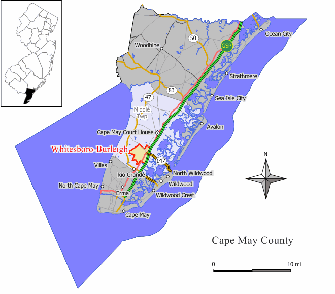
mapsize = 250x200px
map_caption = Map of Whitesboro-Burleigh CDP in Cape May County
mapsize1 =
map_caption1 =subdivision_type = Country
subdivision_name =United States
subdivision_type1 = State
subdivision_name1 =New Jersey
subdivision_type2 = County
subdivision_name2 = Cape May
government_footnotes =
government_type =
leader_title =
leader_name =
leader_title1 =
leader_name1 =
established_title =
established_date =area_footnotes =
area_magnitude =
area_total_km2 = 10.7
area_land_km2 = 10.7
area_water_km2 = 0.0
area_total_sq_mi = 4.1
area_land_sq_mi = 4.1
area_water_sq_mi = 0.0population_as_of = 2000
population_footnotes =
population_total = 1836
population_density_km2 = 172.3
population_density_sq_mi = 446.2timezone = Eastern (EST)
utc_offset = -5
timezone_DST = EDT
utc_offset_DST = -4
elevation_footnotes =
elevation_m =
elevation_ft =
latd = 39 |latm = 2 |lats = 15 |latNS = N
longd = 74 |longm = 51 |longs = 40 |longEW = Wpostal_code_type =
postal_code =
area_code =
blank_name = FIPS code
blank_info = 34-80855GR|2
blank1_name =
blank1_info =
website =
footnotes =Whitesboro-Burleigh is a
census-designated place and unincorporated area located within Middle Township, in Cape May County,New Jersey . It is part of the Ocean CityMetropolitan Statistical Area . As of theUnited States 2000 Census , the CDP population was 1,836.Whitesboro is an unincorporated community in Middle Township, Cape May County,
New Jersey ,United States . It is the principal African American center of the township.History
Whitesboro was founded by an African-American Equitable Industrial Association about 1901 by a group of prominent Black American investors that included
Paul Laurence Dunbar and educatorBooker T. Washington . The community was named forGeorge Henry White , the leading investor, a Washington lawyer who had previously served as a Republican congressman representing North Carolina’s second legislative district. White and his fellow entrepreneurs wanted to create a self-reliant community for blacks, without the discrimination faced the southern states. Shares in the planned community were sold to African Americans from North and South Carolina and Virginia.In 2006, the Johnson Family Historical Trust, discovered the value of its original deed to Whitesboro property from George H White Realty Company, named as one of "America's Untold Treasures", by renowned African American appraiser Phillip Merrill of Nanny and Jack. The Johnson Family Historical Trust holds rare items important to Whitesboro, such as 1936 Nationally Recognized ham radio operator James L Johnson, whose radios were not only particular to him as an aficionado, but to Whitesboro and the nation in technology.
There are more than 50 known and appraised artifacts from the original investors of the town that planned to be featured in Whitesboro in the few years to come. This summer a dig for national history will take place to uncover more artifacts at various historical sites in Whitesboro hosted by the Johnson Family Historical Trust
Geography
Whitesboro-Burleigh is located at coor dms|39|2|15|N|74|51|40|W|city (39.037404, -74.861111).GR|1
According to the
United States Census Bureau , the CDP has a total area of 10.7km² (4.1 mi²). 10.6 km² (4.1 mi²) of it is land and 0.24% is water.Demographics
USCensusPop
1990=2080
2000=1836
footnote=source: [cite web
url=http://factfinder.census.gov/servlet/SAFFPopulation?_event=Search&geo_id=16000US3476010&_geoContext=01000US%7C04000US34%7C16000US3476010&_street=&_county=Whitesboro&_cityTown=Whitesboro&_state=04000US34&_zip=&_lang=en&_sse=on&ActiveGeoDiv=geoSelect&_useEV=&pctxt=fph&pgsl=160&_submenuId=population_0&ds_name=null&_ci_nbr=null&qr_name=null®=null%3Anull&_keyword=&_industry=
title=Population Finder: Whitesboro-Burleigh CDP, New Jersey
publisher=U.S. Census Bureau
accessdate=2007-03-19.] As of thecensus GR|2 of 2000, there were 1,836 people, 759 households, and 478 families residing in the CDP. Thepopulation density was 172.5/km² (446.2/mi²). There were 975 housing units at an average density of 91.6/km² (236.9/mi²). The racial makeup of the CDP was 60.08% White, 35.19% African American, 0.27% Native American, 0.93% Asian, 0.05% Pacific Islander, 1.31% from other races, and 2.18% from two or more races. Hispanic or Latino of any race were 3.10% of the population.There were 759 households out of which 23.2% had children under the age of 18 living with them, 44.1% were married couples living together, 14.1% had a female householder with no husband present, and 37.0% were non-families. 32.8% of all households were made up of individuals and 21.2% had someone living alone who was 65 years of age or older. The average household size was 2.42 and the average family size was 3.05.
In the CDP the population was spread out with 24.0% under the age of 18, 5.7% from 18 to 24, 23.7% from 25 to 44, 21.8% from 45 to 64, and 24.8% who were 65 years of age or older. The median age was 43 years. For every 100 females there were 91.3 males. For every 100 females age 18 and over, there were 83.3 males.
The median income for a household in the CDP was $34,231, and the median income for a family was $42,568. Males had a median income of $32,179 versus $24,612 for females. The
per capita income for the CDP was $16,812. About 4.2% of families and 9.2% of the population were below thepoverty line , including 16.0% of those under age 18 and 9.5% of those age 65 or over.Notable residents
*
Stedman Graham - He was the 1,000-point scorer for the boys varsity basketball team. He is an American educator, author, businessman, speaker and served in the United States Army and known as the partner of media mogulOprah Winfrey . [ [http://abcnews.go.com/GMA/Books/Story?id=2469280&page=2 "Embrace Diversity With Stedman Graham: 'Diversity: Leaders Not Labels' Teaches Readers to Harness Their Skills and Achieve Success"] ,ABC News ,September 21 ,2006 . AccessedJune 17 ,2007 . "Students were bused from Whitesboro to attend Middle Township schools, where I attended an integrated high school."]References
External links
* [http://www.middletownshipgazette.com The Cape May County Gazette] Local community newspaper
* [http://www.middletownshipgazette.com/bc The Beachcomber]
Wikimedia Foundation. 2010.