- Strathmere, New Jersey
Infobox Settlement
official_name = Strathmere, New Jersey
settlement_type = CDP
nickname =
motto =
imagesize =
image_caption =
image_
imagesize =
image_caption =
image_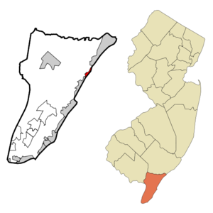
mapsize = 250x200px
map_caption = Map of Strathmere CDP in Cape May County
mapsize1 =
map_caption1 =subdivision_type = Country
subdivision_name =United States
subdivision_type1 = State
subdivision_name1 =New Jersey
subdivision_type2 = County
subdivision_name2 = Cape May
government_footnotes =
government_type =
leader_title =
leader_name =
leader_title1 =
leader_name1 =
established_title =
established_date =area_footnotes =
area_magnitude =
area_total_km2 = 2.1
area_land_km2 = 1.7
area_water_km2 = 0.4
area_total_sq_mi = 0.8
area_land_sq_mi = 0.6
area_water_sq_mi = 0.2population_as_of = 2000
population_footnotes =
population_total = 175
population_density_km2 = 104.1
population_density_sq_mi = 269.6timezone = Eastern (EST)
utc_offset = -5
timezone_DST = EDT
utc_offset_DST = -4
elevation_footnotes =
elevation_m = 1
elevation_ft = 3
latd = 39 |latm = 11 |lats = 48 |latNS = N
longd = 74 |longm = 39 |longs = 27 |longEW = Wpostal_code_type =
ZIP code
postal_code = 08248
area_code = 609
blank_name = FIPS code
blank_info = 34-71250GR|2
blank1_name = GNIS feature ID
blank1_info = 0880969GR|3
website =
footnotes =Strathmere is a
census-designated place and unincorporated area located within Upper Township, in Cape May County,New Jersey . It is part of the Ocean CityMetropolitan Statistical Area . As of theUnited States 2000 Census , the CDP population was 175.History
Strathmere was originally called just Corson's Inlet. The town of Corson's Inlet was annexed to Upper Township in 1905. It was renamed Strathmere around 1912.
Geography
Strathmere is located at coor dms|39|11|48|N|74|39|27|W|city (39.196762, -74.657544)GR|1.
According to the
United States Census Bureau , the CDP has a total area of 2.1km² (0.8 mi²). 1.7 km² (0.6 mi²) of it is land and 0.4 km² (0.2 mi²) of it (18.75%) is water.Demographics
As of the
census GR|2 of 2000, there were 175 people, 93 households, and 54 families residing in the CDP. Thepopulation density was 104.0/km² (269.6/mi²). There were 464 housing units at an average density of 275.6/km² (714.7/mi²). The racial makeup of the CDP was 97.71% White, 1.14% Asian, and 1.14% from two or more races. Hispanic or Latino of any race were 1.71% of the population.There were 93 households out of which 7.5% had children under the age of 18 living with them, 49.5% were married couples living together, 5.4% had a female householder with no husband present, and 40.9% were non-families. 38.7% of all households were made up of individuals and 12.9% had someone living alone who was 65 years of age or older. The average household size was 1.88 and the average family size was 2.44.
In the CDP the population was spread out with 8.0% under the age of 18, 4.0% from 18 to 24, 17.1% from 25 to 44, 36.6% from 45 to 64, and 34.3% who were 65 years of age or older. The median age was 58 years. For every 100 females there were 96.6 males. For every 100 females age 18 and over, there were 96.3 males.
The median income for a household in the CDP was $78,709, and the median income for a family was $77,783. Males had a median income of $40,972 versus $43,750 for females. The
per capita income for the CDP was $52,045. None of the population or families were below thepoverty line .References
External links
* [http://www.strathmere.net/ Strathmere web site]
* [http://www.uppertownshipgazette.com The Upper Township Gazette serving Strathmere] Local community newspaper
Wikimedia Foundation. 2010.