- Montgomery County, Pennsylvania
-
Montgomery County, Pennsylvania 
Flag
Seal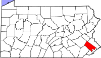
Location in the state of Pennsylvania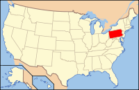
Pennsylvania's location in the U.S.Founded September 10, 1784 Seat Norristown Largest Municipality Norristown Area
- Total
- Land
- Water
487 sq mi (1,261 km²)
483 sq mi (1,251 km²)
4 sq mi (10 km²), 0.89%Population
- (2010)
- Density
799,874
1,653/sq mi (638.4/km²)Congressional districts 2nd, 6th, 7th Time zone Eastern: UTC-5/-4 Website www.montcopa.org Montgomery County is a county located in the U.S. state of Pennsylvania, in the United States. As of 2010, the population was 799,874, making it the third most populous county in Pennsylvania (after Philadelphia and Allegheny counties). The county seat is Norristown.
The county was created on September 10, 1784, out of land originally part of Philadelphia County. It is believed to have been either named in honor of Richard Montgomery, an American Revolutionary War general killed in 1775 while attempting to capture Quebec City, Canada, or for the Welsh county of Montgomeryshire (which was named after one of William the Conqueror's main counselors, Roger de Montgomerie), as it was part of the Welsh Tract, an area of Pennsylvania settled by Quakers from Wales. Early histories of the county indicate the origin of the county's name as uncertain.
Montgomery County is a suburban county northwest of Philadelphia. It is part of the Delaware Valley and marks the region's northern border with the Lehigh Valley region of the state. It is the 20th wealthiest county in the country (measured by personal per-capita income) and was named the 9th Best Place to Raise a Family by Forbes.[1]
Contents
Geography
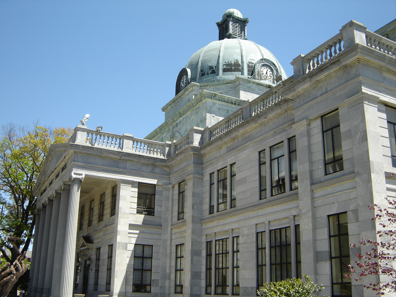
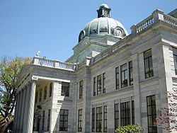 Montgomery County Courthouse
According to the United States Census Bureau, the county has a total area of 487 square miles (1,262 km²), of which 483 square miles (1,251 km²) is land and 4 square miles (11 km²) (0.89%) is water.
Adjacent counties
- Lehigh County (north)
- Bucks County (northeast)
- Philadelphia County (southeast)
- Delaware County (southwest)
- Chester County (west)
- Berks County (northwest)
National protected area
Major roads and highways
 Interstate 76
 Interstate 476
 Interstate 276
 US Route 1
 US Route 30
 US Route 202
 US Route 422
Demographics
Historical populations Census Pop. %± 1790 22,918 — 1800 24,150 5.4% 1810 29,703 23.0% 1820 35,793 20.5% 1830 39,406 10.1% 1840 47,241 19.9% 1850 58,291 23.4% 1860 70,500 20.9% 1870 81,612 15.8% 1880 96,494 18.2% 1890 123,290 27.8% 1900 138,995 12.7% 1910 169,590 22.0% 1920 199,310 17.5% 1930 265,804 33.4% 1940 289,247 8.8% 1950 353,068 22.1% 1960 516,682 46.3% 1970 623,799 20.7% 1980 643,621 3.2% 1990 678,111 5.4% 2000 750,097 10.6% 2010 799,874 6.6% As of the 2010 census, the county was 81.1% White, 8.7% Black or African American, 0.1% Native American or Alaskan Native, 6.4% Asian, 0.0% Native Hawaiian, 1.9% were two or more races, and 1.6% were some other race. 4.3% of the population were Hispanic or Latino.
As of the census[2] of 2000, there were 750,097 people, 286,098 households, and 197,693 families residing in the county. The population density was 1,553 people per square mile (599/km²). There were 297,434 housing units at an average density of 238 units/km² (616 units/sq mi). The racial makeup of the county was 86.46% White, 7.46% Black or African American, 0.11% Native American, 4.02% Asian, 0.03% Pacific Islander, 0.75% from other races, and 1.16% from two or more races. 2.04% of the population were Hispanic or Latino of any race. 17.5% were of German, 16.7% Irish, 14.3% Italian, 6.5% English and 5.0% Polish ancestry according to Census 2000. 90.5% spoke English, 2.0% Spanish, 1.1% Korean and 1.0% Italian as their first language. Historically, much of western Montgomery County is part of the Pennsylvania Dutch Country, with a great many descendants of German-speaking settlers from the 18th Century.
Montgomery County is home to large and growing African American, Korean American, Puerto Rican American, Mexican American and Indian American populations. The county has the second largest foreign-born population in the region.[3]
There were 286,098 households out of which 32.00% had children under the age of 18 living with them, 57.20% were married couples living together, 8.80% had a female householder with no husband present, and 30.90% were non-families. 25.60% of all households were made up of individuals and 9.90% had someone living alone who was 65 years of age or older. The average household size was 2.54 and the average family size was 3.09.
In the county, the population was spread out with 24.10% under the age of 18, 7.10% from 18 to 24, 30.50% from 25 to 44, 23.40% from 45 to 64, and 14.90% who were 65 years of age or older. The median age was 38 years. For every 100 females there were 93.60 males. For every 100 females age 18 and over, there were 90.00 males.
The median income for a household in the county was $60,829, and the median income for a family was $72,183 (these figures had risen to $73,701 and $89,219 respectively as of a 2007 estimate).[4] Males had a median income of $48,698 versus $35,089 for females. The per capita income for the county was $30,898. About 2.80% of families and 4.40% of the population were below the poverty line, including 4.60% of those under age 18 and 5.10% of those age 65 or over.
The following is a table of the largest townships/boroughs in Montgomery County.
Township/Borough Population (2010 US Census) Density mi2 Lower Merion Township 57,825 2,526.1 Abington Township 55,310 3,630.3 Cheltenham Township 36,793 4,083.1 Municipality of Norristown 34,324 9,806.9 Upper Merion Township 28,395 1,593.3 Horsham Township 26,147 1,398.6 Upper Dublin Township 25,569 1,960.7 Lower Providence Township 25,436 1,458.8 Montgomery Township 24,790 2,067.1 Upper Moreland Township 24,015 3,202 Economy
Montgomery County is a suburb of Philadelphia and consequently, many of its residents work in the city. However, Montco is also a major employment center with large business parks in Blue Bell, Lansdale, Fort Washington, Horsham and King of Prussia which attract thousands of workers from all over the region. The strong job base and taxes generated by those jobs have resulted in Montgomery County receiving the highest credit rating of 'AAA' from Standard & Poor's, one of fewer than 30 counties in the United States with such a rating.
Major employers include:
- Abington Memorial Hospital
- Aetna
- BAE Systems
- Dorman Products
- Genuardi's Family Markets
- GlaxoSmithKline
- Holy Redeemer Hospital
- InfoStretch Corporation
- Jefferson Health System
- Johnson & Johnson - McNeil Pharmaceuticals
- Lockheed Martin
- Merck
- Motorola
- Prudential
- Quest Diagnostics
- Rohm and Haas
- Teva Pharmaceuticals
- Unisys
Population growth
Montgomery County's population grew about 10.6% as of the 2000 census with much of the growth in the western part of the county. Much of the growth is attributable to population shifts in the region. The county especially saw an increase of Asian American immigrants [5] as well as in Mexican immigrants. Also, Montgomery County receives a large amount of immigrants, and many migrants from other urban areas, looking for cheaper real estate compared to their areas. Montgomery County provides many expressways to Philadelphia, New Jersey, and many other places in Pennsylvania. Census Bureau projections show a slowing of the growth this decade. Part of the slowing of the growth is attributed to the massive emigration of native born residents.
Politics
Presidential elections results Year Republican Democrat 2008 39.2% 165,552 60.0% 253,393 2004 44.0% 174,741 55.6% 222,048 2000 43.8% 145,623 53.5% 177,990 1996 41.2% 121,047 48.9% 143,664 1992 39.5% 125,704 42.9% 136,572 1988 60.2% 170,294 38.8% 109,834 1984 64.2% 181,426 35.3% 99,741 1980 57.8% 156,996 31.0% 84,289 1976 56.9% 155,480 41.2% 112,644 1972 64.3% 173,662 34.1% 91,959 1968 54.3% 141,621 39.3% 102,464 1964 43.0% 102,714 56.7% 135,657 1960 60.7% 142,796 39.2% 92,212 As of January 2010, there are 577,378 registered voters in Montgomery County.[6]
- Democratic: 262,204 (45.41%)
- Republican: 231,531 (40.10%)
- Other parties: 83,643 (14.49%)
While Republicans have dominated county politics, the Democratic Party has made substantial gains in the county over the last 20 years and gained the registration edge early in 2008. After voting for the Republican Presidential nominee for six consecutive elections from 1968 to 1988, the Democratic Presidential nominee has carried Montgomery for the past five consecutive elections by progressively increasing margins. Most county-level offices were held by Republicans until after the 2007 election, when Democrats picked up control of five row offices. Democrats have also won significant[says who?] elections for the Pennsylvania General Assembly in recent years, including two GOP-leaning State House districts in 2004, the 148th with Mike Gerber and the 153rd with Josh Shapiro.
In the 2004 US Senate election, Republican Arlen Specter won the county over Montco resident Joe Hoeffel, but Democrat Bob Casey, Jr. out-polled Rick Santorum in the 2006 Senate election. In 2006, Democrat Rick Taylor unseated incumbent Republican Eugene McGill in the 151st and, in 2008, Democrat Matthew Bradford unseated incumbent Republican Jay Moyer in the 70th. Six out of twelve of the 12 Montgomery State Representative seats are now held by Democrats, but Daylin Leach is the only Democrat in a Montgomery State Senate seat, the 17th. All four statewide Democratic candidates carried Montgomery in 2008, with Barack Obama receiving 60% of the county's vote.
Montgomery County is governed by a three-person County Commission. The current composition is two Republicans and one Democrat. By law, the County Commission must have one member of a minority party represented.
The current commissioners are:
- Jim Matthews - Chair - (R)
- Joe Hoeffel - (D)
- Bruce Castor - (R)
The county row officers are:
- Clerk of Courts - Ann Thornburg Weiss (D)
- Controller - Diane Morgan (D)
- Coroner - Walter Hoffman (D)
- District Attorney - Risa Vetri Ferman (R)
- Prothonotary - Mark Levy (D)
- Recorder of Deeds - Nancy Becker (R)
- Register of Wills - D. Bruce Hanes (D)
- Sheriff - Eileen Whalon Behr (R)
- Treasurer - Thomas Jay Ellis (R)
The new officials took office in January 2008.
Montgomery County contains parts of six Congressional Districts: the 2nd, 6th, 7th, 8th, 13th, and 15th. The Montgomery-based 13th district, which also includes most of Northeast Philadelphia, is represented by Democrat Allyson Schwartz.
State Representatives
- Robert Godshall, Republican, 53rd district
- Kate Harper, Republican, 61st district
- Matthew Bradford, Democrat, 70th district
- Tom Quigley, Republican, 146th district
- Marcy Toepel, Republican, 147th district
- Mike Gerber, Democrat, 148th district
- Tim Briggs, Democrat, 149th district
- Mike Vereb, Republican, 150th district
- Todd Stephens, Republican, 151st district
- Thomas Murt, Republican, 152nd district
- Josh Shapiro, Democrat, 153rd district
- Lawrence Curry, Democrat, 154th district
- Warren Kampf, Republican, 157th district
- Brendan Boyle, Democrat, 170th district
- Kathy Manderino, Democrat, 194th district
State Senators
- LeAnna Washington, Democrat, 4th district
- Vincent Hughes, Democrat, 7th district
- Charles T. McIlhinney Jr., Republican, 10th district
- Stewart Greenleaf, Republican, 12th district
- Daylin Leach, Democrat, 17th district
- Andy Dinniman, Democrat, 19th district
- Bob Mensch, Republican, 24th district
- John Rafferty, Jr., Republican, 44th district
US Representatives
- Chaka Fattah, Democrat, 2nd district (Cheltenham only)
- Jim Gerlach, Republican, 6th district
- Pat Meehan, Republican, 7th district
- Mike Fitzpatrick, Republican, 8th district
- Allyson Schwartz, Democrat, 13th district
- Charlie Dent, Republican, 15th district
Municipalities
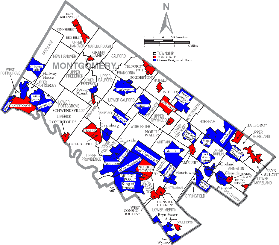
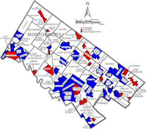 Map of Montgomery County, Pennsylvania with Municipal Labels showing Boroughs (red), Townships (white), and Census-designated places (blue).
Under Pennsylvania law, there are five types of incorporated municipalities: cities, boroughs, townships, Home Rule Municipalities (which can include communities that bear the name "Borough" or "Township") and, in at most two cases, towns. The following boroughs, townships, and Home Rule Municipalities are located in Montgomery County:
Home Rule Municipalities
- Bryn Athyn (official name remains "Borough of Bryn Athyn")
- Cheltenham Township
- Horsham Township
- Norristown
- Plymouth Township
- Whitemarsh Township
Boroughs
- Red Hill
- Rockledge
- Royersford
- Schwenksville
- Souderton
- Telford (lies partly in Bucks County)
- Trappe
- West Conshohocken
Townships
- Abington Township
- Douglass Township
- East Norriton Township
- Franconia Township
- Hatfield Township
- Limerick Township
- Lower Frederick Township
- Lower Gwynedd Township
- Lower Merion Township
- Lower Moreland Township
- Lower Pottsgrove Township
- Lower Providence Township
- Lower Salford Township
- Marlborough Township
- Montgomery Township
- New Hanover Township
- Perkiomen Township
- Plymouth Township
- Salford Township
- Skippack Township
- Springfield Township
- Towamencin Township
- Upper Dublin Township
- Upper Frederick Township
- Upper Gwynedd Township
- Upper Hanover Township
- Upper Merion Township
- Upper Moreland Township
- Upper Pottsgrove Township
- Upper Providence Township
- Upper Salford Township
- West Norriton Township
- West Pottsgrove Township
- Whitpain Township
- Whitemarsh Township
- Worcester Township
Communities and census-designated places
Census-designated places are geographical areas designated by the U.S. Census Bureau for the purposes of compiling demographic data. They are not actual jurisdictions under Pennsylvania law. Other unincorporated communities, such as villages, may be listed here as well.
Education
Colleges and universities
- Arcadia University
- Bryn Athyn College of the New Church
- Bryn Mawr College
- Gwynedd Mercy College
- Haverford College
- Manor College
- Montgomery County Community College
- Pennsylvania College of Optometry
- Penn State Abington - a commonwealth campus of The Pennsylvania State University
- Rosemont College
- St. Charles Borromeo Seminary
- Temple University - Ambler and Ft. Washington campuses and Tyler School of Art in Elkins Park
- Ursinus College
- Westminster Theological Seminary
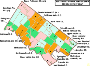 Map of Montgomery County, Pennsylvania Public School Districts
Public school districts
- Abington School District
- Boyertown Area School District
- Cheltenham Township School District
- Colonial School District
- Hatboro-Horsham School District
- Jenkintown School District
- Lower Merion School District
- Lower Moreland Township School District
- Methacton School District
- Norristown Area School District
- North Penn School District
- Perkiomen Valley School District
- Pottsgrove School District
- Pottstown School District
- Souderton Area School District
- Springfield Township School District
- Spring-Ford Area School District
- Upper Dublin School District
- Upper Merion Area School District
- Upper Moreland School District
- Upper Perkiomen School District
- Wissahickon School District
- Bryn Athyn School District - exists as an entity, but does not operate any schools. Public school students attend class in neighboring districts. [7]
Private secondary schools
- Academy Of The New Church Boys School
- Academy Of The New Church Girls School
- Abington Friends School
- The Baldwin School
- Jack M. Barrack Hebrew Academy, formerly known as the Akiba Hebrew Academy
- Bishop McDevitt High School
- Calvary Baptist School
- Christopher Dock Mennonite High School
- Coventry Christian Schools
- The Episcopal Academy
- Friends' Central School
- Germantown Academy
- Gwynedd Mercy Academy High School
- Haverford School
- The Hill School
- Huntingdon Valley Christian Academy
- Indian Creek Mennonite School
- Kennedy-Kenrick Catholic High School, CLOSED. Replaced by Pope John Paul II Catholic High School in 2010.
- Lakeside School
- Lansdale Catholic High School
- La Salle College High School
- Lincoln Academy
- Main Line Academy
- Martin Luther School
- Mary, Mother of the Redeemer Catholic School
- Meadowbrook School
- Merion Mercy Academy
- Mount Saint Joseph Academy
- New Life Youth & Family Svcs
- The Pathway School
- The Perkiomen School
- Pope John Paul II Catholic High School, replaced Kennedy-Kenrick Catholic High School and Saint Pius X High School in 2010.
- Reformation Christian School
- Saint Aloysius School
- Saint Basil Academy
- Saint Katherine Day School
- Saint Pius X High School, CLOSED. Replaced by Pope John Paul II Catholic High School in 2010.
- Stowe Lighthouse Christ Academy
- The Shipley School
- Torah Academy of Greater Philadelphia
- Trinity Christian Academy[disambiguation needed
 ]
] - Valley Forge Baptist Academy
- Wordsworth Academy
- Wyncote Academy
Night schools/adult education
Notable civic institutions
- The Institutes for the Achievement of Human Potential (IAHP), a nonprofit organization founded by Glenn Doman, was established in Wyndmoor in 1955. The IAHP is an educational organization that teaches parents about child brain development, and is a treatment center for brain-injured children.
The Historical Society of Montgomery County, founded in 1881, preserves and promotes the history of the county and its people. It also owns and maintains historic Montgomery Cemetery, the oldest non-sectarian cemetery in Montgomery County.
See also
- List of municipal authorities in Montgomery County, Pennsylvania
- National Register of Historic Places listings in Montgomery County, Pennsylvania
References
- ^ forbes.com
- ^ "American FactFinder". United States Census Bureau. http://factfinder.census.gov. Retrieved 2008-01-31.
- ^ [1][dead link]
- ^ Montgomery County, Pennsylvania - Fact Sheet - American FactFinder
- ^ [2][dead link]
- ^ Running for Office
- ^ Meetings & Notices
External links
Education in Montgomery County, Pennsylvania Colleges and Universities Arcadia University • Bryn Athyn College • Bryn Mawr College • Gwynedd–Mercy College • Haverford College • Manor College • Montgomery County Community College • Salus University • Penn State Abington • Rosemont College • St. Charles Borromeo Seminary • Temple University Ambler • Ursinus College • Westminster Theological Seminary
Public school districts Abington School District • Boyertown Area School District • Cheltenham Township School District • Colonial School District • Hatboro-Horsham School District • Jenkintown School District • Lower Merion School District • Lower Moreland Township School District • Methacton School District • Norristown Area School District • North Penn School District • Perkiomen Valley School District • Pottsgrove School District • Pottstown School District • Souderton Area School District • Springfield Township School District • Spring-Ford Area School District • Upper Dublin School District • Upper Merion Area School District • Upper Moreland School District • Upper Perkiomen School District • Wissahickon School District • Bryn Athyn School District
Private secondary schools Academy Of The New Church Boys School • Academy Of The New Church Girls School • Abington Friends School • Akiba Hebrew Academy • Baldwin School • Bishop McDevitt High School • Calvary Baptist School • Christopher Dock Mennonite High School • Coventry Christian Schools • Episcopal Academy • Friends' Central School • Germantown Academy • Gwynedd Mercy Academy High School • The Haverford School • The Hill School • Huntingdon Valley Christian Academy • Indian Creek Mennonite School • Akiba Hebrew Academy • Kennedy-Kenrick Catholic High School • Lakeside School • Lansdale Catholic High School • La Salle College High School • Lincoln Academy • Main Line Academy • Martin Luther School • Mary, Mother of the Redeemer Catholic School • Meadowbrook School • Merion Mercy Academy • Mount Saint Joseph Academy • New Life Youth & Family Svcs • The Pathway School • The Perkiomen School • Pope John Paul II Catholic High School • Reformation Christian School • Saint Aloysius School • Saint Basil Academy • Saint Katherine Day School • Saint Pius X High School • Stowe Lighthouse Christ Academy • Shipley School • Torah Academy of Greater Philadelphia • Trinity Christian Academy • Valley Forge Baptist Academy • Wyncote Academy
 Commonwealth of Pennsylvania
Topics - Cities
- Politics
- Government
- Delegations
- History
- Geography
- Geology
- Pennsylvanians
- State parks
- Symbols
- Visitor attractions
Metro areas Cities Largest
municipalities- Baldwin
- Berwick
- Bethel Park
- Brentwood
- Carlisle
- Chambersburg
- Columbia
- Darby
- Dunmore
- Elizabethtown
- Emmaus
- Ephrata
- Franklin Park
- Hanover
- Indiana
- Kingston
- Lansdale
- Lansdowne
- Monroeville
- Munhall
- Murrysville
- Norristown
- Penn Hills
- Phoenixville
- Plum
- Pottstown
- State College
- West Chester
- West Mifflin
- Whitehall
- Wilkinsburg
- Wyomissing
- Yeadon
Regions - Allegheny Mountains
- Allegheny National Forest
- Allegheny Plateau
- Atlantic Coastal Plain
- Blue Ridge
- Coal Region
- Cumberland Valley
- Delaware Valley
- Dutch Country
- Endless Mountains
- Happy Valley
- Laurel Highlands
- Lehigh Valley
- Main Line
- Northeast
- Northern Tier
- Northwestern
- Oil Region
- Pennsylvania Highlands
- Piedmont
- The Poconos
- Ridge and Valley
- South Central
- Susquehanna Valley
- Western
- Wyoming Valley
Counties - Adams
- Allegheny
- Armstrong
- Beaver
- Bedford
- Berks
- Blair
- Bradford
- Bucks
- Butler
- Cambria
- Cameron
- Carbon
- Centre
- Chester
- Clarion
- Clearfield
- Clinton
- Columbia
- Crawford
- Cumberland
- Dauphin
- Delaware
- Elk
- Erie
- Fayette
- Forest
- Franklin
- Fulton
- Greene
- Huntingdon
- Indiana
- Jefferson
- Juniata
- Lackawanna
- Lancaster
- Lawrence
- Lebanon
- Lehigh
- Luzerne
- Lycoming
- McKean
- Mercer
- Mifflin
- Monroe
- Montgomery
- Montour
- Northampton
- Northumberland
- Perry
- Philadelphia
- Pike
- Potter
- Schuylkill
- Snyder
- Somerset
- Sullivan
- Susquehanna
- Tioga
- Union
- Venango
- Warren
- Washington
- Wayne
- Westmoreland
- Wyoming
- York
Delaware Valley Counties Atlantic • Berks • Bucks • Burlington • Camden • Cape May • Cecil • Chester • Cumberland • Delaware • Gloucester • Mercer • Montgomery • New Castle • Ocean • Philadelphia • Salem
Major cities Cities and towns
50k-99kBensalem • Camden • Cherry Hill • Gloucester Township • Levittown • Reading • Trenton • Vineland • WilmingtonCities and towns
25k-50kCategories:- Pennsylvania counties
- Montgomery County, Pennsylvania
- 1784 establishments in the United States
- Populated places established in 1784


Wikimedia Foundation. 2010.