- McKean County, Pennsylvania
-
McKean County, Pennsylvania 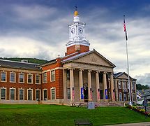 McKean County Courthouse
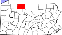
Location in the state of Pennsylvania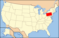
Pennsylvania's location in the U.S.Founded March 26, 1804 Seat Smethport Largest city Bradford Area
- Total
- Land
- Water
984 sq mi (2,549 km²)
982 sq mi (2,543 km²)
3 sq mi (8 km²), 0.26%Population
- (2010)
- Density
43,450
44/sq mi (17/km²)Website www.mckeancountypa.org McKean County is a county located in the U.S. state of Pennsylvania. As of 2010, the population was 43,450. Its county seat is Smethport[1]. The county was named in honor of former Pennsylvania Governor and Declaration of Independence signer Thomas McKean.
Contents
Geography
According to the U.S. Census Bureau, the county has a total area of 984 square miles (2,549 km²), of which 982 square miles (2,542 km²) is land and 3 square miles (7 km²) (0.26%) is water.
Adjacent counties
- Cattaraugus County, New York (north)
- Allegany County, New York (northeast)
- Potter County (east)
- Cameron County (southeast)
- Elk County (south)
- Forest County (southwest)
- Warren County (west)
Major Roads
 US Route 6
 US Route 219
 Pennsylvania Route 44
 Pennsylvania Route 46
 Pennsylvania Route 59
 Pennsylvania Route 146
 Pennsylvania Route 155
 Pennsylvania Route 321
 Pennsylvania Route 346
 Pennsylvania Route 446
 Pennsylvania Route 546
 Pennsylvania Route 646
 Pennsylvania Route 770
National protected area
- Allegheny National Forest (part)
- Allegheny National Recreation Area (part)
Demographics
Historical populations Census Pop. %± 1810 142 — 1820 728 412.7% 1830 1,439 97.7% 1840 2,975 106.7% 1850 5,254 76.6% 1860 8,859 68.6% 1870 8,825 −0.4% 1880 42,565 382.3% 1890 46,863 10.1% 1900 51,343 9.6% 1910 47,868 −6.8% 1920 48,934 2.2% 1930 55,167 12.7% 1940 56,673 2.7% 1950 56,607 −0.1% 1960 54,517 −3.7% 1970 51,915 −4.8% 1980 50,653 −2.4% 1990 47,131 −7.0% 2000 45,963 −2.5% 2010 43,450 −5.5% [2][3] As of the census[4] of 2000, there were 45,936 people, 18,024 households, and 12,094 families residing in the county. The population density was 47 people per square mile (18/km²). There were 21,644 housing units at an average density of 22 per square mile (9/km²). The racial makeup of the county was 96.46% White, 1.87% Black or African American, 0.32% Native American, 0.30% Asian, 0.02% Pacific Islander, 0.40% from other races, and 0.61% from two or more races. 1.06% of the population were Hispanic or Latino of any race. 21.9% were of German, 13.3% Irish, 12.6% Italian, 11.2% American, 8.7% Swedish and 8.6% English ancestry according to Census 2000.
There were 18,024 households out of which 30.50% had children under the age of 18 living with them, 52.50% were married couples living together, 10.10% had a female householder with no husband present, and 32.90% were non-families. 28.30% of all households were made up of individuals and 13.30% had someone living alone who was 65 years of age or older. The average household size was 2.40 and the average family size was 2.93.
In the county, the population was spread out with 23.70% under the age of 18, 7.90% from 18 to 24, 28.50% from 25 to 44, 23.20% from 45 to 64, and 16.70% who were 65 years of age or older. The median age was 39 years. For every 100 females there were 100.40 males. For every 100 females age 18 and over, there were 98.70 males.
Municipalities
 Map of McKean County , Pennsylvania with Municipal Labels showing Boroughs (red) and Townships (white).
Under Pennsylvania law, there are four types of incorporated municipalities: cities, boroughs, townships, and, in at most two cases, towns. The following cities, boroughs and townships are located in McKean County:
City
Boroughs
Townships
- Annin Township
- Bradford Township
- Ceres Township
- Corydon Township
- Eldred Township
- Foster Township
- Hamilton Township
- Hamlin Township
- Keating Township
- Lafayette Township
- Liberty Township
- Norwich Township
- Otto Township
- Sergeant Township
- Wetmore Township
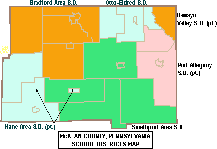
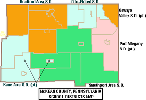 Map of McKean County, Pennsylvania School Districts
Education
Public School Districts
- Bradford Area School District
- Kane Area School District (Also covers part of Elk County)
- Otto-Eldred School District
- Port Allegany School District (Also covers part of Potter County)
- Smethport Area School District
- Oswayo Valley School District (Also covers part of Potter County)
The 500 school districts of Pennsylvania were ranked for student academic achievement by the Pittsburgh Business Times in 2008.
- Bradford Area School District - 403rd
- Kane Area School District - 342nd
- Otto-Eldred School District - 408th
- Port Allegany School District - 446th
- Smethport Area School District - 415th
- Oswayo Valley School District - 458th
Private Schools
As reported by EdNA, Pennsylvania Department of Education, June 2010.
- Bradford Area Christian Academy, Bradford
- Chestnut Street Christian School, Bradford
- St. Bernard School, Bradford
Recreation
There is one Pennsylvania state park in McKean County. Kinzua Bridge State Park is between U.S. Route 6 and Pennsylvania Route 59, just east of the Allegheny National Forest near Mount Jewett.
See also
- List of municipal authorities in McKean County, Pennsylvania
- National Register of Historic Places listings in McKean County, Pennsylvania
References
- ^ "Find a County". National Association of Counties. http://www.naco.org/Counties/Pages/FindACounty.aspx. Retrieved 2011-06-07.
- ^ http://factfinder2.census.gov
- ^ http://mapserver.lib.virginia.edu/
- ^ "American FactFinder". United States Census Bureau. http://factfinder.census.gov. Retrieved 2008-01-31.
External links
- A resource website for families in McKean County including the McKean County Resource Directory
- McKean County Government
- McKean County Capitol History
- Bradford Today
- Gardeau Train Wreck of 2006 - A website dedicated to the train wreck and chemical spill of June 30, 2006. Location: Gardeau, Norwich Township, McKean County, Pennsylvania
Municipalities and communities of McKean County, Pennsylvania City 
Boroughs Eldred | Kane | Lewis Run | Mount Jewett | Port Allegany | Smethport
Townships Unincorporated
communitiesBurning Well | Coryville | Cyclone | Farmers Valley | Gifford | Ludlow
Coordinates: 41°48′40″N 78°26′41″W / 41.81111°N 78.44472°W
Categories:- Pennsylvania counties
- McKean County, Pennsylvania
- 1804 establishments in the United States
- Populated places established in 1804


Wikimedia Foundation. 2010.