- Altoona, Pennsylvania
-
Altoona 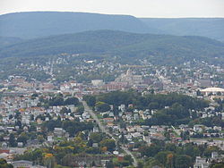
Nickname(s): The Mountain City[1] Location of Blair County in Pennsylvania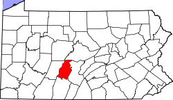 Location of Altoona in Blair County
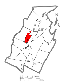
Coordinates: 40°30′39″N 78°23′59″W / 40.5107°N 78.3997°WCoordinates: 40°30′39″N 78°23′59″W / 40.5107°N 78.3997°W Country  United States
State Pennsylvania County Blair County Founded 1849 Incorporated (borough) February 6, 1854 Incorporated (city) 1868 Government – Mayor Bill Schirf Area – Total 9.8 sq mi (25.3 km2) – Water 0 sq mi (0 km2) Elevation 1,206 ft (368 m) Population (2010) – Total 46,320 – Density 5,068.9/sq mi (1,957.1/km2) Time zone EST (UTC-5) – Summer (DST) EDT (UTC-4) Area code(s) 814 School District: Altoona Area School District Website www.altoonapa.gov Zip codes: 16601, 16602, 16603.
Local phone exchanges:
940, 941, 942, 943, 944, 946, 947, 949Altoona is a city in Blair County, Pennsylvania, United States. It is the principal city of the Altoona Metropolitan Statistical Area (MSA). The population was 46,320 at the 2010 census estimate, making it the tenth most populous city in Pennsylvania. The Altoona MSA includes all of Blair County and had an estimated population of 127,089 in 2010 (according to the U.S. Census), around 105,000 of which live within a 5-mile (8.0 km) radius of the Altoona city center, according to U.S. Census zip code population data.
Having grown around the railroad industry, the city is currently working to recover from industrial decline and urban decentralization experienced in recent decades. The city is home to the Altoona Curve baseball team of the Double A Eastern League, which is the Double A affiliate of the Major League Baseball team Pittsburgh Pirates. It also houses the 75+ year-old Altoona Symphony Orchestra,[2] under the direction of Teresa Cheung. Prominent landmarks include the Horseshoe Curve, the Railroaders Memorial Museum, the Juniata Shops of the Altoona Works, the Mishler Theatre, the Cathedral of the Blessed Sacrament, and the Jaffa Shrine Center.
Altoona is also the home of the Sheetz headquarters. Sheetz is one of the largest convenience store and gas station chains in the country, with stores in Pennsylvania, Maryland, Ohio, West Virginia, Virginia, and North Carolina. Because of this, approximately 20 Sheetz stores[3] are located in and around Altoona. Sheetz is one of the featured companies in the Morgan Spurlock documentary Pom Wonderful Presents: The Greatest Movie Ever Sold. To promote itself, as well as the film, the City of Altoona agreed to change its name temporarily to the title of the film and be known as Pom Wonderful Presents: The Greatest Movie Ever Sold, PA for 60 days for a fee of $25,000. The city held a ceremony on April 27 to salute the documentary, followed by a screening.[4]
Geography
According to the United States Census Bureau, the city has a total area of 9.8 sq mi (25.3 km²), all land. Altoona is situated in the Allegheny Mountains.
Altoona is located at 40°30′39″N 78°23′59″W / 40.51083°N 78.39972°W (40.510720, -78.399758).[5]
Adjacent municipalities
Altoona lies at the base of Brush Mountain within Logan Valley and Pleasant Valley. There are several townships outside of Altoona city limits that, although autonomous, use the name Altoona for postal and name-place designation. They include the townships of: Logan Township and Tyrone Township, as well as small parts of Allegheny Township and Frankstown Township.
- Blair County
- Logan Township (encompassing)
- Antis Township (north)
- Tyrone Township(northeast)
- Allegheny Township (south)
- Duncansville(south)
- Frankstown Township (southeast)
- Hollidaysburg(south)

Punxsutawney
DuboisClearfield
TyroneState College
LewistownIndiana
Ebensburg
Harrisburg
Carlisle Altoona

Johnstown
SomersetHollidaysburg
BedfordMartinsburg
ChambersburgClimate data for Altoona Month Jan Feb Mar Apr May Jun Jul Aug Sep Oct Nov Dec Year Record high °F (°C) 78
(26)75
(24)85
(29)92
(33)94
(34)96
(36)103
(39)102
(39)96
(36)90
(32)82
(28)74
(23)103
(39)Average high °F (°C) 32
(0)35
(2)45
(7)58
(14)68
(20)77
(25)81
(27)80
(27)72
(22)61
(16)49
(9)37
(3)57.8 Average low °F (°C) 16
(−9)18
(−8)26
(−3)37
(3)47
(8)55
(13)60
(16)58
(14)51
(11)41
(5)32
(0)22
(−6)38.5 Record low °F (°C) −25
(−32)−22
(−30)−7
(−22)8
(−13)21
(−6)32
(0)38
(3)34
(1)26
(−3)15
(−9)0
(−18)−13
(−25)−25
(−32)Precipitation inches (mm) 2.64
(67.1)2.43
(61.7)3.48
(88.4)3.63
(92.2)4.30
(109.2)4.08
(103.6)4.14
(105.2)3.50
(88.9)3.85
(97.8)3.43
(87.1)3.71
(94.2)3.11
(79)42.64
(1,083.1)Source: Pennsylvania State Climatologist[6] History
A major railroad town, Altoona was founded by the Pennsylvania Railroad in 1849 as the site for a shop complex. Altoona was incorporated as a borough on February 6, 1854, and as a city under legislation approved on April 3, 1867, and February 8, 1868. The town grew rapidly in the late 19th century, its population approximately 2,000 in 1854, 10,000 in 1870, and 20,000 in 1880.
The word Altoona is a derivative of the Latin word altus, meaning "high".[7]
This explanation for the naming of Altoona is contradicted by Pennsylvania Place Names.[8] Although Altoona, in Blair Country, is popularly known as "the Mountain City," its name has no direct or indirect etymological relation to the Latin adjective altus, signifying "elevated, lofty." Two very different explanations of the origin of this name are current. The one which seems to be most natural and reasonable runs as follows: "The locomotive engineer who ran the first train into Altoona in 1851 was Robert Steele, who died several years ago, aged nearly ninety years. He was then the oldest continuous resident of the city. He was much respected, and had long been one of the private pensioners of Andrew Carnegie. Mr. Steele is authority for the statement that Colonel Beverly Mayer, of Columbia, Pennsylvania, who, as a civil engineer of what was then the Pennsylvania Central Railway, had laid out the tracks in the yards of the newly projected city, named the place Altoona after the city of Altona in Schleswig-Holstein, which became part of Germany in 1862." The German Altona, which lies on the right bank of the Elbe immediately west of Hamburg, is an important railway and manufacturing centre with a population of nearly 200,000. The etymological derivation of the name Altona is not known with certainty, but widely believed to be Low German all to na, meaning "all too near" (sc. Hamburg).
The popular explanation derives the name of Altoona from Allatoona, said to be a Cherokee Indian name. In 1849 David Robinson sold his farm to Archibald Wright of Philadelphia, who transferred the property to his son, John A. Wright, who laid it out in building lots, became one of the founders of Altoona, and was responsible for the naming of the town. According to his own statement, he had spent considerable time in the Cherokee country of Georgia, where he had been especially attracted by the beautiful name of Allatoona, which he had bestowed upon the new town in the belief that it was a Cherokee word meaning "the high lands of great worth." In the Cherokee language there is a word eladuni, which means "high lands," or "where it is high"; but to a Cherokee, Allatoona and eladuni are so different that the former could hardly be derived from the latter.
An older history dated 1883 [9] favored the Cherokee derivation, stating that "Its name is not derived from the Latin word altus nor from the French word alto, as has frequently been asserted and published, but from the beautiful, liquid, and expressive Cherokee word allatoona. This is on the authority of the person who bestowed the name, Mr. Wright, of Philadelphia, who was long a resident of the Cherokee country in Georgia, and an admirer of the musical names of that Indian language."
The demand for locomotives during the Civil War stimulated much of this growth, and by the later years of the war Altoona was known as a valuable city for the North. It was considered by Confederate General Robert E. Lee as a target during the Army of Northern Virginia's mid-1863 entry into Pennsylvania, before being repelled at the Battle of Gettysburg. Also notable is the Union's Loyal War Governors' Conference, held at Altoona's Logan House Hotel, which politically backed Abraham Lincoln's recently released Emancipation Proclamation following Union victory at the Battle of Antietam in September 1862. Altoona was also the site of the first Interstate Commission meeting to create and design the Gettysburg National Cemetery following the devastating Battle of Gettysburg. The centrality and convenience of the town's rail transportation was what brought these two important gatherings to the city during the war.
The Horseshoe Curve, a famous curved section of track owned by the Pennsylvania Railroad, has become a tourist attraction and National Historic Landmark. The Curve was used to raise trains to a sufficient elevation to cross the Allegheny Ridge to the west, beyond which was the steel town of Pittsburgh and the rest of the western United States. Because it was the industrial link to the western U.S., the Horseshoe Curve was a primary target of eight Nazi saboteurs who had infiltrated the United States during World War II (1942) by being dropped off by U-boats of the German Navy (Kriegsmarine) during Operation Pastorius.
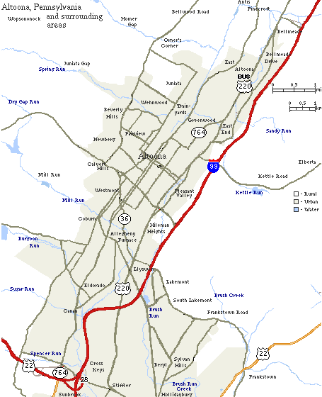
 Map of Altoona and some surrounding areas
In the early 20th century, the Railroad's Altoona Works complex employed, at its peak, approximately 15,000 people and covered three miles (5 km) in length, 218 acres (880,000 m²) of yards and 37 acres (150,000 m²) of indoor workshop floor space in 122 buildings. The Pennsylvania Railroad built many of its own locomotives at the Works, some 7,873 in all, the last being constructed in 1946.[citation needed]
The Railroad had a significant influence on the city, creating the city's fire departments and relocating the hospital to a site nearer to the shop's gates. Today, the fire department employs 65 personnel and is the largest career department between Harrisburg and Pittsburgh, PA.[10] The railroad sponsored a city band and constructed Cricket Field (a sports complex). In 1853, the Railroad built the Mechanic's Library, the first industrial library in the nation which exists today as the Altoona Public Library.[11] With the decline in railroad demand after World War II, things began to decline steadily afterwards, with most of the plant is now gone. Many of the historic treasures of the city's history have also disappeared, including the aforementioned Logan House Hotel.
Altoona is one of the dual seats of the Roman Catholic Diocese of Altoona-Johnstown. The Cathedral of the Blessed Sacrament was made a cathedral and rechristened from St. John's Church in 1851.
The Altoona Mirror newspaper,[12] founded in 1876 by Harry Slep, is Altoona's oldest media outlet. Today, the newspaper has a daily circulation of 32,000 and a Sunday circulation of 39,000. Approximately 13,000 people read the online edition of the newspaper each day.
Today, Altoona serves as the corporate home to Sheetz, a rapidly growing convenience store chain in the United States. It now has 383 locations throughout Pennsylvania, Virginia, Maryland, West Virginia, Ohio and North Carolina.
Altoona is home to the world's oldest wooden roller coaster, the Leap the Dips, located in Lakemont Park.
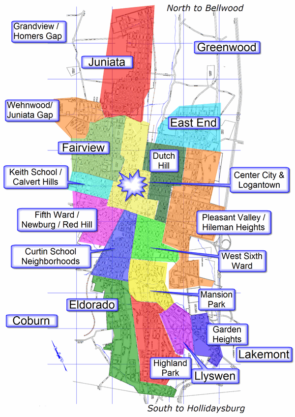
Sections
 Map of Altoona Neighborhoods
The main sections of Altoona are the Downtown, Center City, Logantown, Fairview, Juniata, Wehnwood, Calvert Hills, 5th Ward, Curtin, Eldorado, East End, Dutch Hill, Pleasant Valley, Hileman Heights, 6th Ward, Mansion Park, Llyswen, Garden Heights, and Highland Park. Some areas within Logan Township are not within the defined City limits but still considered sections of Altoona, including: Lakemont, Greenwood and Bellmeade. Many of the older districts consist of a mix of rowhomes and individual homes, which were a common building style in railroad towns so-as to provide for worker and manager housing, respectively.
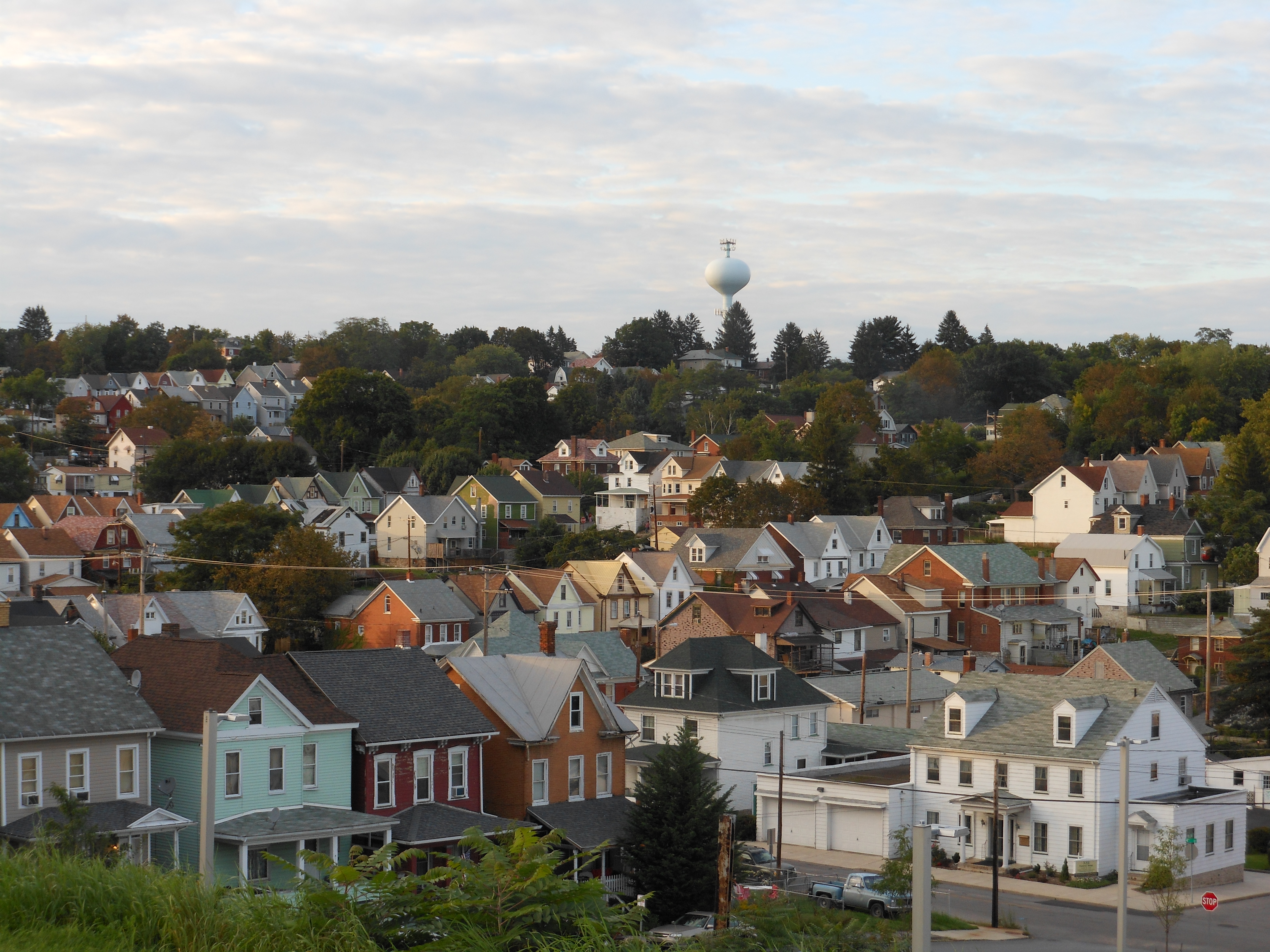
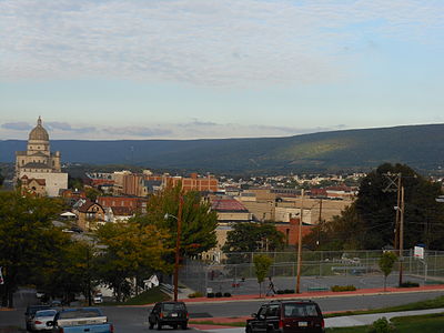 A view of Downtown from a 5th Ward hill
Downtown
The Downtown is the cultural and commercial center of Altoona and straddles the famous railroads. Much of the downtown area is listed on the National Register of Historic Places as the Downtown Altoona Historic District.[13] Popular landmarks include the Mishler Theatre, the Penn Alto Building (formerly the Penn Alto Hotel), the Gable's Building, City Hall, the Cathedral of the Blessed Sacrament, and Eleventh Avenue itself.
One unique little known fact is that the Texas Hot Dog was originally created in downtown Altoona in 1918, although the Paterson, New Jersey Texas Hot Dog location, which opened in 1924, is more famous.
Because of the geography of the area, exact or natural boundaries for Downtown are not present. Therefore Downtown is generally defined by what the City has zoned as Central Business: between 13th Ave and the PRR Expressway, and from 7th Street to 16th Street. However it is common for areas within Logantown and Center City to be expressed locally as "downtown."
As is typical to a traditional city layout, the downtown is centrally located and contains significant development in all directions from the downtown. The commercial core of the downtown includes many multistory residential, commercial, and mixed-use facilities designed in at the turn-of-the-20th-century in a mix of Victorian, Edwardian Baroque, and Neo-Romanesque styles. This style features high ceilings, resulting in taller buildings than is typical for the number of floors. The high ceilings are typically made of either tin or plaster, although sometimes a drop ceiling is utilized.
Individual homes originally provided housing to managers and executives of the Pennsylvania Railroad and can be best recognized by the structural similarities to Victorian or Edwardian mansions, but built very narrow and tall with little to no space between the two structures. These are sometimes used as double or triple family apartments or even converted into commercial space. Outside of the commercial core is a mosaic of multistory commercial structures, mixed use facilities, single story commercial structures, apartment buildings, multi-unit housing, and single-family homes.
Downtown Altoona is notable for having several churches, such as the Cathedral of the Blessed Sacrament at the corner of 13th Street and 13th Avenue, the Presbyterian church on the corner of 12th Street and 14th Avenue, and the First Lutheran Church on the corner of 14th Street and 12th Avenue. The Station Medical Center, formerly known as the Station Mall, was a downtown mall built during the 1970s in place of many old railroad shops. The downtown contains most of what's known as Altoona's Little Italy district.
As has been typical of many rust belt cities, the economic downturn of the railroad resulted in the closure of many of the downtown's landmark stores and industries; and the simultaneous rise in prominence of the automobile shifted commercial development to the suburbs. However, through recent revitalization efforts, Altoona's downtown maintains a significant level of economic vitality and hosts few office and residential vacancies.[citation needed] The downtown maintains a significant focus on pedestrian-oriented development, as evidenced by the presence of more pedestrian bridges and underpasses across the railroad tracks (connecting the two parts of Downtown) than automobile crossings.
Penn State Altoona has bought several downtown buildings, including the former Playhouse Theater building, the six-story Penn Furniture building, and the former WRTA building. The University has turned them into the Devorris Downtown Center, the Aaron Building and the Kazmaier Family Building. Recently Sheetz has added another building to Penn State Altoona called The Sheetz Center for Entrepreneurial Excellence on the former site of a department store just behind the Amtrak Station. The University provides a flow of resources into the downtown, aiding in revitalization efforts. As an example of the university's value to the downtown's economy, the installation of the Blue Lot near the Wolf Court Building has improved the economic attraction of downtown by offering up to three hours of free parking. A bike path connecting the Campus to Downtown Altoona has also been built.
Center City
Center City comprises industrial and commercial zones as well as urban and multiple household residential zones. On the west side of the tracks, Center City extends around Downtown 2-3 blocks with heavy residential, industrial and commercial to the north, south and west. The eastern side of the tracks, which according to the public maps is called "East Side," runs along the length of the tracks from 1st Street to 23rd street and from the tracks to 6th Ave west to east. However, the Altoona Area High School is considered Center City despite standing on the Dutch Hill side of 6th Ave. The East Side of Center City is home to the High School and Junior High, the former Roosevelt Junior High School, the Altoona Railroaders Museum, Boyer Candies, the Station Medical Center of Altoona Regional Health System, as well as many current and old railroad facilities.
Logantown
Logantown is the area just north of the Downtown and is considered a direct extension of Downtown. It borders Fairview along 16th Ave, Willow Ave and Cherry Ave to the north, 13th Ave and Chestnut Ave to the south, and Juniata Gap Road to the east. This is where the Altoona Hospital of the Altoona Regional Health System is located, which is the tallest building in Altoona at 14 Floors. This is also where Cricket Field used to be located. Logantown is zoned as a mix of commercial and residential, and contains some of the oldest houses built in Altoona that are still standing.
 Fairview
Fairview
Fairview is a mostly residential area North and West of Downtown and Logantown. It borders Calvert Hills to the south at 12th Street, Downtown and Logantown to the east along 16th Ave and Willow Ave and then along Cherry Ave after 5th Street, and borders Juniata Gap Road to the north. Fairview is zoned as multiple household residential in the areas directly bordering Downtown, and transitions to single household residential after 21st Ave, and eventually to suburban after 24th Ave. At times, you see some single unit houses on 13th through 16th Avenues, and 16th through 18th Streets, amongst much taller office, retail, and apartment buildings. Many of the houses in the part of downtown near Fairview and lower Fairview are the middle-density mansions originally owned by managers and executives of the Pennsylvania Railroad. The most striking example of this is the Penn Alto residential hotel on the corner of 13th Avenue and 12th Street, which has two single-unit houses next to it. Conversely, there are a few multistory residential and commercial buildings on 17th Avenue. Fairview could be best described as the urban neighborhoods that one would expect to find just outside of a downtown. One of the sections of the downtown is called "Lower Fairview" due to its transitionary nature.
Dutch Hill
Dutch Hill district contains an abundance of historic neighborhoods and traditional "corner markets". This section gets its name from the abundance of Germans who moved into this area when the City was still expanding. Dutch Hill is the area that borders the City Center to the East and is zoned as multiple household residential. The boundaries are generally considered 1st Street to 17th Street north to south, and 6th Ave to Walton Ave from west to east. However as the Altoona Area High School and Junior High are considered City Center, the border is around 4th Ave when closer to 17th Street.
Juniata
Juniata is defined as north of Juniata Gap Road, east of 14th Ave and on the west side of the tracks. The area is zoned as mostly residential limited, but also uniquely has a significant area of light and heavy industrial as well as a central business area. This is because Juniata was once its own city, and was incorporated into Altoona in the late 19th century. Because of this, the section's street names had conflicting numbers with the rest of the City, and had to be given a North prefix. The commercial area is sometimes nicknamed "downtown Juniata." The most important street in Juniata's L-shaped commercial district is North Fourth Avenue. The J.L. Noble School was added to the National Register of Historic Places in 1996.[14]
East End
The East End is typically defined as the area on the east side of the tracks north of 1st Ave. It is called the East End because it borders the north end of the tracks where trains would depart east towards Philadelphia. Because of this, most streets have an East prefix. The East End is mostly single household residential and suburban, but has small areas of residential-commercial and neighborhood business along Kettle Street and Lloyd Street, as well as highway business along Pleasant Valley Blvd.
Pleasant Valley
Pleasant Valley is the area that centers around Pleasant Valley Boulevard, which is a massive stretch of highway business that runs the entire length of Altoona. The massive Sheetz store known locally as "Supersheetz" is located here along 17th Street and was the first of its kind ever built. The area is defined as southeast of Walton Ave and extends from 1st Street til 12th Street, and between 12th Street and 17th Street is between 1st Ave to the west and Pleasant Valley Blvd to the east, and from 17th Street south to 27th Street is between 1st Ave to the west and Robin Ave to the east. As well as the large highway business area, Pleasant Valley also has an even amount of single household residential and suburban along with some small stretches of residential commercial and urban.
Eldorado
Eldorado, pronounced locally, El-doe-ray-doe, is the southern section of Altoona, south of Logan Boulevard and west of 6th Avenue as well as a small section south of 57th Street all the way to Rhode Island Ave(Goods Lane) in the east. Eldorado is zoned as almost entirely suburban, with small areas of light industrial and neighborhood business. The Sheetz Headquarters is located in this area. At one time, this section was also known as the "West End" because trains leaving the south end of town head west towards Pittsburgh. Some parts of Eldorado are actually outside of incorporated Altoona and located in Allegheny Township and Logan Township.
Lakemont
Lakemont is located southeast of Garden Heights between Frankstown Road and Logan Boulevard. While residing within Logan Township just outside of the official border of the City and designated as the "Village of Lakemont," it is commonly accepted as a section of Altoona. In fact, Blair County Ballpark the home of the Altoona Curve resides in Lakemont. Also in Lakemont is Lakemont Park and Galactic Ice. Lakemont is zoned as single household residential, residential commercial and highway business.
Greenwood
Greenwood is the area north of the East End and begins around a block north of Grant Street. While mostly residing within Logan Township just outside of the official border of the City and designated as the "Village of Greenwood," it is commonly accepted as a section of Altoona. Greenwood is zoned almost entirely as suburban with a section of highway business along Route 220.
Wehnwood
Wehnwood is the area west of 25th Ave between Wehnwood Road to the north and 1st St to the south. This is part of where Penn State Altoona is located. Wehnwood is mostly zoned as suburban or single residential with an area of neighborhood business along 25th Ave and Juniata Gap Road. There is a fair amount of student housing surrounding the campus, and therefore a small pocket of urban residential next to it.
Garden Heights
Garden heights is the area east of Plank Road, north of Lakemont and south of Frankstown Road. Garden Heights is mostly single residential, but is highway business along Plank Road, residential commercial along parts of Frankstown Road and Logan Blvd, and light industrial south of Logan Blvd. This is the only section of the defined city limits that Interstate 99 actually passes through.
Mansion Park
Mansion Park gets its name from the famous historical Baker Mansion which stands in this area. There are several streets surrounding the old plantation where mansions built in the early 20th century still stand. Mansion Park Stadium is also located here, which is the 10,000 seat stadium where the Altoona Mountain Lions play. The Mansion Park area is located east of 6th Ave, with Logan Blvd and Ward Ave to the south, 27th Street to the north and a block past Union Ave to the east. It is single and suburban residential.
6th Ward
6th Ward is the area south of Dutch Hill, west of Pleasant Valley, east of Curtain Neighborhoods and north of Mansion Park. It is between 17th and 27th Streets north to south, and 6th Ave and Michelle Drive west to east. This area consists of multiple and single residential. There are several streets in the 6th Ward where mansions from the early 20th century still stand.
Hileman Heights
Hileman Heights is a suburban area on the eastern side of Pleasant Valley. The Swiss Club is located here. This area is east of Pleasant Valley Blvd and between South 12th Street to the north and 17th Street to the south. There is also a small section of residential commercial.
Curtin Neighborhoods
The Curtin Neighborhoods is the area on the east side of the tracks south of 21st street and between the 5th Ward and the tracks to the west and the 9th Ave tracks to the east. Curtin is zoned as multiple, single and suburban residential as well as residential commercial and light industrial. This is probably one of the more varied and diverse areas of the city architecturally. This is the area where the Jaffa Mosque is located. The Broad Avenue Historic District was added to the National Register of Historic Places in 2002.[14]
Highland Park
Highland Park is the area south of Logan Blvd, east of 6th Ave, north of 57th Street and west of Ruskin Drive. The name comes from the hill that the area is centered on is the only significant highland in southern Altoona. The actual Highland Park is located on top of the hill. Highland Park is zoned entirely suburban. The Knickerbocker Historic District was added to the National Register of Historic Places in 2002.[14]
Calvert Hills
Calvert Hills is a small area between 12th Street and 16th Street north to south and 17th Ave to the east. This is the area of multiple, single and suburban residential on the hills around the former Keith Junior High School, which is now an apartment complex.
5th Ward and Red Hill
The 5th Ward is the area on the west side of the tracks south of Calvert Hills and north of the Curtain Neighborhoods. The northwestern corner between 16th Street and 21st Street is known as Red Hill. The boundaries for the southern area are 20th Street to the north and 10th Ave to the south. The 5th Ward is a mix of single and suburban residential.
Llyswen
Llyswen is a small section west of Union Ave, east of Ruskin Drive, south of Ward Ave and north of Plank Road. This low lying area is almost entirely suburban, with small areas of multiple residential, residential commercial, neighborhood business and highway business. The Llyswen Historic District was added to the National Register of Historic Places in 2002.[14]
Transportation
Altoona is a major center on the Norfolk Southern Railway's Pittsburgh Line. In Altoona, helper engines are added to heavy trains to give them extra power up and over the Horseshoe Curve west of town. The Juniata Heavy Repair Shop Complex, originally built by the Pennsylvania Railroad, is the primary repair and maintenance facility on the Norfolk Southern Railway. On an average day, 60 to 80 trains pass though Altoona. The historical importance to the railroad industry and the current high level of railroad activity has made Altoona a mecca for railfans for over 60 years, with the Railroaders Memorial Museum and the Horseshoe Curve being popular spots for individuals to take photographs of passing trains.
In addition to the many freight trains, Amtrak's Pennsylvanian train stops at Altoona station once daily in each direction, and also makes use of the Horseshoe Curve.
Local bus service in the city is provided by AMTRAN. In 2007, AMTRAN customers suffered a major loss in service due to cuts in state funding. In May of that year, Governor Rendell visited Altoona to discuss plans intended to rectify this situation.
Roadway service primarily consists of Interstate 99, which provides access to the Pennsylvania Turnpike to the south and Interstate 80 to the north; and U.S. Route 22, which provides east-west service and direct access to Pittsburgh and Harrisburg. Local roadways in Altoona tend to be given numerical names, and Streets are aligned northwest-southeast and Avenues are aligned northeast-southwest.
The Altoona-Blair County Airport provides commercial air service for Altoona, offering daily flights to Washington Dulles International Airport.
Parks
Altoona has many, various types of parks for a variety of public uses within the city limits. They range from simple green areas with perhaps some benches and a few swings to full athletic fields for the public use and enjoyment.
- Memorial Park - runs along Juniata Gap road between N 14th and N 8th Avenues
- Fairview Park - on the corner of 2nd St and 25th Ave
- Geesey Park - in between Grant and Bell Avenues along 3rd St
- Gospel Hill Park - on the hill above the Cathedral of the Blessed Sacrament
- Prospect Park - in between 13th and 15th Streets along 1st Ave
- Westfall Park - between Mill Run and Rt 36
- Tuckahoe Park - along Union Ave near 29th Street
- Mansion Park - along Logan Blvd and 5th Ave
- Highland Park - along 4th Ave in between 44th and 49th Streets
- Lakemont Park - between Logan Blvd and Frankstown Road, amusement park with the world famous Leap the Dips
- Booker T Washington - on 13th Ave and 19th St: Fitness Park, Basketball Court and playground
- John Roberston Walking Park - 7th St and 7th Ave on both sides of bridge
Sports
Team Sport League Championships Venue Altoona Curve Baseball Eastern League; Western Division 1 Blair County Ballpark In the early 20th century, the Pennsylvania Railroad constructed a large sports complex at the intersection of Chestnut Avenue and Seventh Street.[15] It was named Cricket Field in an attempt to appeal to Cricket-loving British investors. Cricket did not catch on with the Altoona populace, so its close relative baseball became the choice for Cricket Field. Well known baseball players as Babe Ruth and Josh Gibson played at Cricket Field, and the stadium was also the venue for numerous other sporting events, musical competitions, marching units, and activities.[11] A plaza stands today on the site of Cricket Field.
Altoona was the site of a 1.25-mile (2.01 km) board track called Altoona Speedway from 1923 to 1931.[16]
Mansion Park Stadium
Altoona Area School District's Mansion Park Stadium has long been recognized as one of the finest athletic complexes in Pennsylvania. The stadium, which has a seating capacity of 10,400, is a source of community pride and regularly serves as the site of a variety of events which benefit the economy of the Altoona-Blair County area.
In the summer of 2009, Sports Construction Group, LLC installed “Trophy Turf,” which has a 48-ounce face weight and inlaid football and soccer lines.
Mansion Park's first artificial surface was installed in 1989. Omniturf provided a way to maximize the use of the facility throughout the year and at the same time, save taxpayer dollars through reduced maintenance costs. AstroTurf 12-2000 was installed in 1999. The eight-lane polyurethane running track was installed in 1989 and has been resurfaced several times.
For 22 consecutive seasons, the playing surface has received rave reviews from players and coaches as athletes have experienced controlled footing regardless of the weather conditions. Most importantly, there has been a significant decrease in serious injuries since the artificial turf was installed.
During a typical fall season, more than 60 events take place on the turf. Altoona High varsity and junior varsity teams, Altoona Area Junior High School ninth grade teams, and Bishop Guilfoyle High School all play home football games at Mansion Park. The stadium is also the site of AAHS boys and girls soccer matches and countless practice sessions. District and interdistrict football and soccer playoffs are held each year at Mansion Park, the home of the PIAA Football Championships from 1992 through 1997. The Pennsylvania Scholastic Football Coaches Association East West High School All Star Game was played at Mansion Park from 2001-2010.
Numerous high school and junior high school track meets, including the District 6 Class AA and AAA championships and the West Central Coaches Meet, are held at the stadium each spring. The track is also used extensively on a daily basis by hundreds of community residents who enjoy walking and jogging.
Mansion Park has also been the site of a 1992 Pittsburgh Steeler intrasquad scrimmage, the Pennsylvania State Athletic Conference men's and women's college soccer championships, University of Pittsburgh preseason football practices and the 1995 PIAA Soccer Championships.
Music events have also been well-received. Appearances by the Beach Boys, Up With People, the United States Marine Drum and Bugle Corps, the Penn State Blue Band, the Ohio State Pride of the Buckeyes Band, the University of Notre Dame Band of the Fighting Irish, the University of Illinois Marching Illini and the Indiana University of Pennsylvania Marching Band have attracted huge crowds. Drum Corps International competitions were held in 1998 and again in 2000.
Altoona Area High School's Commencement is scheduled at the stadium each year. Mansion Park is also the home of the American Cancer Society's Relay for Life.
In early 2010, a new scoreboard featuring a video display board with an improved stadium sound system was erected thanks to the generosity of local sponsors.[17]
Education
Altoona has an education system that contains two high schools, one parochial, one public. Bishop Guilfoyle High School is the private parochial school having grades 9-12, located at 2400 Pleasant Valley. Blvd. Altoona Area High School[18] houses grades 10-12, and is located at 1415 6th Ave. Altoona High is much larger than Bishop Guilfoyle, graduating around 600 students annually, while Guilfoyle graduates around 100. Most athletic teams at Bishop Guilfoyle are the smallest classification within the Pennsylvania Interscholastic Athletic Association (PIAA), which is Class single A. In contrast, those at Altoona Area High School are the largest classification within the PIAA, which is AAAA. These high schools occasionally compete against each other in basketball, volleyball, tennis, cross country and softball.
It also contained two junior high schools, named D.S. Keith Junior High and Theodore Roosevelt Junior High, but both closed and merged in 2008 to become the Altoona Area Junior High School. Roosevelt was torn down and the ground on which it stood was constructed into the new field for the new junior high. Keith, however, was turned into residential apartments.
Altoona is also home to The Pennsylvania State University, Ivyside Park campus, also known as Penn State Altoona. This is the third largest of the Penn State Commonwealth Campuses. The college has approximately 4,182 students as of the 2009-10 school year.[19]
Shopping and retail
Altoona is the linchpin of Tri-City Region. Its location along I-99 draws from a large trade area over a wide geographic area that extends to State College and Johnstown and over 40 miles (64 km) south along I-99 past I-70. Altoona draws the most retail customers in the region due to its centralized location and to the fact that it has the best complimentary retail of the three markets with 2,800,000 square feet (260,000 m2) of retail space.[20]
The scale and diversity of retail within the City of Altoona and the surrounding area is not paralleled within the region. The areas of retail include:
- Downtown
- The 17th Street corridor including what remains of the Station Mall.
- Certain large zoned sections along Logan Blvd and 6th Ave.
- The Logan Valley Mall which is a major retail staple of the area.
- Essentially the entire length of about 3.5 miles (5.6 km) of Pleasant Valley Blvd and Valley View Blvd as they converge into Plank Road, consisting of numerous stores and shopping centers.
- The Walmart and Target shopping centers.
- The Logan Town Centre which is the newest and arguably the best and most diverse shopping center that sits directly next to I-99.
- As well as several more plazas and centers just to the North and South of the city.
Media
Newspapers
- Altoona Mirror
Radio
Radio stations in the Altoona, Pennsylvania market By FM frequency By AM frequency By callsign Pennsylvania radio markets: Allentown-Bethlehem • Altoona • Bradford-Coudersport • Chambersburg-Waynesboro • Erie • Harrisburg-Lebanon-Carlisle • Lancaster • Montrose • New Castle • Philadelphia • Pittsburgh • Reading • State College • Sunbury-Selinsgrove-Lewisburg • Wilkes Barre-Scranton • Sayre-Towanda-Mansfield-Wellsboro • Williamsport • York
Other Pennsylvania radio regions: Bedford • Indiana • Johnstown • Lewistown-Mifflintown • Meadville-Franklin • Punxsutawney-DuBois • St. Marys-Emporium-Kane • Stroudsburg • Warren
See also: List of radio stations in PennsylvaniaFM stations call letters frequency format location Owner WHHN 88.1 Religious Hollidaysburg Radio Maria, Inc. WRXV 89.1 Christian Contemporary State College Invisible Allies Ministries WUFR 91.1 Religious Bedford Family Radio WJSM 92.7 Religious Martinsburg Martinsburg Broadcasting, Inc. WHPA 93.5 Oldies Gallitzin Vernal Enterprises, Inc. WBXQ 94.3 Country Patton Sherlock Broadcasting WBRX 94.7 Adult Contemporary Cresson Sherlock Broadcasting WFGI 95.5 Country Johnstown Forever Broadcasting WKYE 96.5 Adult Contemporary Johnstown Forever Broadcasting WFGY 98.1 Country Altoona Forever Broadcasting WRKW 99.1 Rock Ebensburg Forever Broadcasting WWOT 100.1 Top 40 Altoona Forever Broadcasting W274BE 102.7 Christian Contemporary Altoona Invisibile Allies Ministries WLAK 103.5 Hot AC Huntingdon First Media Radio, LLC WALY 103.9 Hot AC Bellwood Forever Broadcasting WRKY 104.9 Rock Hollidaysburg Forever Broadcasting WQCK 105.9 Rock State College Magnum Broadcasting W294AE 106.7 Public Radio Altoona Pennsylvania State University WMES 107.7 Religious Altoona Lay Stewardship Educational Association AM stations call letters frequency format location Owner WHUN 1150 News/Talk Huntingdon Megahertz Licenses, LLC WRTA 1240 News/Talk Altoona Handsome Brothers, Inc. WFBG 1290 News/Talk Altoona Forever Broadcasting WKMC 1370 Nostalgia Roaring Spring Handsome Brothers, Inc. WVAM 1430 Sports Altoona Forever Broadcasting Television
The Johnstown/Altoona/State College market is the 101st largest in the country. The following box contains a list of television stations in the area.
Broadcast television in West-Central Pennsylvania, including Johnstown, Altoona and State College Local stations WPSU (3.1 PBS, 3.2 Create, 3.3 PBS World) - WJAC (6.1 NBC, 6.2 Me-TV) - WWCP (8.1 Fox, 8.2 WATM) - WTAJ (10.1 CBS) - WSCP-CA (13 Ind) - WPCW (19.1 CW) - WATM (23.1 ABC HD, 23.2 WWCP HD, 23.3 This TV) - WHVL-LP (29.1 MNTV, 29.2 A1) - W36BE-D (16.1 ABC, 16.2 Antenna TV) - W41CF (41 Ind) - WKBS (47.1 COR) - WLLS-LP (49 A1)
Local cable
channelsIUP-TV (Ind)
Adjacent locals Pennsylvania Broadcast television: Binghamton, NY • Buffalo, NY • Elmira, NY • Erie • Johnstown/Altoona/State College • New York City • Philadelphia • Pittsburgh • Scranton/Wilkes-Barre • Susquehanna Valley (Harrisburg) • Washington, DC • Youngstown, OH
Demographics
Historical populations Census Pop. %± 1860 3,591 — 1870 10,610 195.5% 1880 19,710 85.8% 1890 30,337 53.9% 1900 38,973 28.5% 1910 52,127 33.8% 1920 60,331 15.7% 1930 82,054 36.0% 1940 80,214 −2.2% 1950 77,177 −3.8% 1960 69,407 −10.1% 1970 63,115 −9.1% 1980 57,078 −9.6% 1990 51,881 −9.1% 2000 49,523 −4.5% 2010 46,320 −6.5% As of the census[21] of 2000, there were 49,523 people, 20,059 households, and 12,576 families residing in the city. The population density was 5,069.7 people per square mile (1,957.1/km²). There were 21,681 housing units at an average density of 2,219.5 per square mile (856.8/km²). The racial makeup of the city was 96.01% White, 2.49% African American, 0.10% Native American, 0.32% Asian, 0.02% Pacific Islander, 0.24% from other races, and 0.83% from two or more races. Hispanic or Latino of any race were 0.74% of the population.
There were 20,059 households out of which 28.4% had children under the age of 18 living with them, 44.6% were married couples living together, 13.8% had a female householder with no husband present, and 37.3% were non-families. 31.6% of all households were made up of individuals and 14.7% had someone living alone who was 65 years of age or older. The average household size was 2.37 and the average family size was 2.98.
In the city the population was spread out with 22.9% under the age of 18, 10.9% from 18 to 24, 27.3% from 25 to 44, 22.0% from 45 to 64, and 16.8% who were 65 years of age or older. The median age was 37 years. For every 100 females there were 88.3 males. For every 100 females age 18 and over, there were 84.5 males.
The median income for a household in the city was $28,248, and the median income for a family was $36,758. Males had a median income of $28,851 versus $21,242 for females. The per capita income for the city was $15,213. About 12.9% of families and 17.7% of the population were below the poverty line, including 24.1% of those under age 18 and 9.0% of those age 65 or over.
Notable people
- Harry J. Anslinger, first Commissioner of the Federal Bureau of Narcotics.
- Michael Behe, professor of biochemistry, author, proponent of Intelligent design.
- Brad Benson, former professional football player, New York Giants.
- William Philip Benson Jr., Artist and founder of Work Hard/Play Hard Productions.
- Andrew Jackson Bettwy, Mayor of Nogales, Arizona (1935–1937).
- Janet Blair, film actress.
- Ron Blazier, former baseball player, Philadelphia Phillies
- Rob Boston, author, advocate of church-state separation.
- Bill and Bob Boyer, founders of Boyer Brothers Inc., commonly known as Boyer Candies.
- Paul Revere Braniff, entrepreneur.
- Samuel Canan, the 34th Governor of American Samoa (September 3, 1945 – September 10, 1945)
- Sam Cohn, New York talent agent (1929–2009)
- Ripper Collins, Professional baseball player, member of the Gashouse Gang. Stats [1]
- Charlie Crist, governor of Florida.
- Paul C. Donnelly, former NASA manager.
- John Ebersole, former professional football player New York Jets
- Danny Fortson, professional basketball player Seattle Supersonics
- Art Greenwald, Writer, Author, Journalist.
- Hedda Hopper is buried in Rose Hill Cemetery in Altoona
- Tommy Irwin, baseball player.
- Mike Iuzzolino, basketball player.
- Richard T. James, Inventor of the slinky.
- Stan Jones, Pro Football Hall of Famer (inducted 1991).
- Robert Jubelirer politician.
- Henry Kloss, engineer.
- Robert E. Laws, Medal of Honor recipient, World War II.
- James Loy, former Deputy Secretary of the U.S. Department of Homeland Security.
- John J. McGuire, science fiction writer.
- Johnny Moore, basketball player.
- John Pielmeier, playwright and screenwriter.
- H. Beam Piper, Novelist and author of "Fuzzy" & 'Paratime' novels.
- Mike Reid, football player, musician.
- Wade Schalles, all time record holder for most pins and most wins in amateur wrestling.
- Elaine Shaffer, flutist (http://www.allmusic.com/artist/elaine-shaffer-q52521/biography)
- Bob Sheetz, founder of the Sheetz convenience store chain.
- D. Brooks Smith, judge.
- Harry E. Soyster, General.
- Benjamin Taylor, Innovationist.
- Paul Winter, American saxophonist,
- Doug West, former NBA basketball player
- Andrew Kevin Walker, Screenwriter
- Steve Nelson[disambiguation needed
 ], Teacher, Graphic Designer
Sister cities
Altoona is a sister city with:
 St. Pölten, Austria
See also
- Dutch Hill (Altoona)
- War Governors' Conference
- Mishler Theatre
- Railroaders Memorial Museum
- Penn Alto Building
References
- ^ http://www.pennsylvania-mountains-of-attractions.com/railroaders-memorial.html
- ^ "Altoona Symphony Orchestra". http://www.altoonasymphony.org/. Retrieved 2007-09-22.
- ^ http://www.sheetz.com/main/locations/searchByState.cfm
- ^ Elliott, Stuart (April 14, 2011). "Altoona Becomes ‘Pom Wonderful' — For a Price". The New York Times. http://mediadecoder.blogs.nytimes.com/2011/04/14/altoona-becomes-pom-wonderful-for-a-price/?partner=rss.
- ^ "US Gazetteer files: 2010, 2000, and 1990". United States Census Bureau. 2011-02-12. http://www.census.gov/geo/www/gazetteer/gazette.html. Retrieved 2011-04-23.
- ^ "Monthly Averages for Altoona, PA". psac.met.psu. June 2011. http://pasc.met.psu.edu/cgi-bin/lcdclim.cgi. Retrieved 2009-07-05.
- ^ Gannett, Henry (1905). The origin of certain place names in the United States. Government Printing Office. p. 22. http://books.google.com/books?id=BqwPAAAAIAAJ&pg=PA22.
- ^ Espenshade, A. Howry: Pennsylvania Place Names, Page 175-176. Genealogical Publishing Co, Inc., Baltimore, Maryland, 1970
- ^ Africa, J. Simpson: History of Huntingdon and Blair Counties, Pennsylvania, page 135. J. B. Lippincott & Co. Philadelphia, 1883.
- ^ "Altoona Firefighters Local 299". http://www.altoonafirefighters.org. Retrieved 2007-09-22.
- ^ a b "Historical Society of Pennsylvania". http://www.hsp.org/default.aspx?id=477.
- ^ "Altoona Mirror". http://www.altoonamirror.com/. Retrieved 2007-09-22.
- ^ "National Register of Historic Places - Blair County". http://www.nationalregisterofhistoricplaces.com/PA/Blair/districts.html.
- ^ a b c d "National Register Information System". National Register of Historic Places. National Park Service. 2010-07-09. http://nrhp.focus.nps.gov/natreg/docs/All_Data.html.
- ^ "RootsWeb Blair place names". http://www.rootsweb.com/~pablair/place.html.
- ^ Motorsport Memorial: Ray Keech, Retrieved July 24, 2007
- ^ http://www.aasdcat.com/aasd/district/campus/mansionpark.html
- ^ "Altoona Area School District". http://www.aasdcat.com/aasd. Retrieved 2007-09-22.
- ^ http://budget.psu.edu/FactBook/StudentDynamic/EnrollmentFallToFallComparison.aspx?SemesterCodes=200809FA200910FA&FBPlusIndc=N
- ^ http://www.logantowncentre.net/Centre_overview.htm
- ^ "American FactFinder". United States Census Bureau. http://factfinder.census.gov. Retrieved 2008-01-31.
External links
- Forever Free: Blair County's Civil War.
- Altoona travel guide from Wikitravel
- City of Altoona, official website
- Historical Photos & Images of Altoona
- Historical Photos of Altoona and the Pennsylvania Railroad
Municipalities and communities of Blair County, Pennsylvania City Altoona

Boroughs Bellwood | Duncansville | Hollidaysburg | Martinsburg | Newry | Roaring Spring | Tunnelhill‡ | Tyrone | Williamsburg
Townships CDPs Unincorporated
communityFootnotes ‡This populated place also has portions in an adjacent county or counties
Attractions Downtown · Horseshoe Curve · Lakemont Park (Leap-The-Dips) · Mishler Theatre · Logan Valley Mall · Penn Alto Building · Railroaders Memorial Museum · Allegheny Portage RailroadTransportation Religion Cathedral of the Blessed Sacrament · Roman Catholic DioceseEducation Industry Sports Newspapers Altoona MirrorTV/Radio Broadcast television in West-Central Pennsylvania, including Johnstown, Altoona and State College Local stations WPSU (3.1 PBS, 3.2 Create, 3.3 PBS World) - WJAC (6.1 NBC, 6.2 Me-TV) - WWCP (8.1 Fox, 8.2 WATM) - WTAJ (10.1 CBS) - WSCP-CA (13 Ind) - WPCW (19.1 CW) - WATM (23.1 ABC HD, 23.2 WWCP HD, 23.3 This TV) - WHVL-LP (29.1 MNTV, 29.2 A1) - W36BE-D (16.1 ABC, 16.2 Antenna TV) - W41CF (41 Ind) - WKBS (47.1 COR) - WLLS-LP (49 A1)
Local cable
channelsIUP-TV (Ind)
Adjacent locals Pennsylvania Broadcast television: Binghamton, NY • Buffalo, NY • Elmira, NY • Erie • Johnstown/Altoona/State College • New York City • Philadelphia • Pittsburgh • Scranton/Wilkes-Barre • Susquehanna Valley (Harrisburg) • Washington, DC • Youngstown, OH
Radio stations in the Altoona, Pennsylvania market By FM frequency By AM frequency By callsign Pennsylvania radio markets: Allentown-Bethlehem • Altoona • Bradford-Coudersport • Chambersburg-Waynesboro • Erie • Harrisburg-Lebanon-Carlisle • Lancaster • Montrose • New Castle • Philadelphia • Pittsburgh • Reading • State College • Sunbury-Selinsgrove-Lewisburg • Wilkes Barre-Scranton • Sayre-Towanda-Mansfield-Wellsboro • Williamsport • York
Other Pennsylvania radio regions: Bedford • Indiana • Johnstown • Lewistown-Mifflintown • Meadville-Franklin • Punxsutawney-DuBois • St. Marys-Emporium-Kane • Stroudsburg • Warren
See also: List of radio stations in PennsylvaniaCategories:- Altoona, Pennsylvania
- Cities in Pennsylvania
- Populated places established in 1849
- Populated places in Blair County, Pennsylvania
- Blair County


Wikimedia Foundation. 2010.