- Fayette County, Pennsylvania
-
Fayette County, Pennsylvania 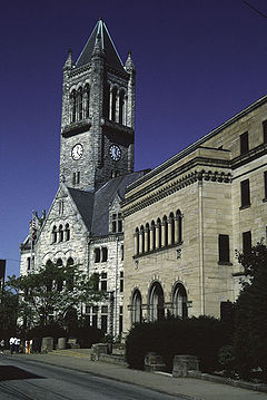 Fayette County Courthouse
Seal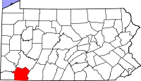
Location in the state of Pennsylvania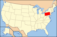
Pennsylvania's location in the U.S.Founded September 26, 1783 Seat Uniontown Largest city Uniontown Area
- Total
- Land
- Water
798 sq mi (2,067 km²)
790 sq mi (2,046 km²)
8 sq mi (21 km²), 0.98%Population
- (2010)
- Density
136,606
173/sq mi (66.7/km²)Website www.co.fayette.pa.us Fayette County is a county located in the U.S. state of Pennsylvania. As of the 2010 census, the population was 136,606. The county is part of the Pittsburgh Metropolitan Statistical Area.
Fayette County was created on September 26, 1783, from part of Westmoreland County and named after the Marquis de Lafayette. Its county seat is Uniontown.[1]
Contents
History
The first Europeans in Fayette County were explorers, who used an ancient American Indian trail that bisected the county on their journey across the Appalachian Mountains. In 1754, when ownership the area was still in dispute, 22-year-old George Washington fought against the French at Jumonville Glen and Fort Necessity. British forces under Washington and General Edward Braddock improved roads throughout the region, making the future Fayette County an important supply route. During the American Revolution, Fayette County was pllagued by attacks from British-allied Indians and remained an isolated frontier region. Also retarding settlement was a border dispute with Virginia; Virginia's District of West Augusta and Pennsylvania's Westmoreland County both claim the area. In 1780 the dispute was settled in favor of Pennsylvania, and Fayette County was formed from Westmoreland County in 1783.
Fayette County settlers provided the new United States government with first test in the 1793 Whiskey Rebellion, when farmers rebelled against tax collectors to protest of a new liquor tax. President George Washington called out the militias to restore order. Fayette County continued to be important to travelers in the early 1800s. The National Road provided a route through the mountains for settlers heading west. The shipyards in Brownsville on the Monongahela River built ships for both the domestic and international trade.
As Pittsburgh developed in the mid-19th century, Fayette County become a center of coal mining and coke production. From the 1880s to the early 1900s, an explosion in steel production became nationally important. New immigrants were attracted to Fayette County to seek jobs. The Scottish and German farming communities were soon overshadowed by new populations from Southern and Eastern Europe. The region's wealth nevertheless remained concentrated in the old English and Scottish families with connections to Pittsburgh.
By World War II, Fayette County had a new unionized working class that enjoyed increased prosperity. In the 1950s, however, the coal industry fell into decline; in the 1970s, the collapse of American steel brought hard times to the County. Industrial restructuring meant the loss of the union jobs which had brought so many families to the middle class. Only a few mines now remain, but natural resources remain crucial to the local economy. The region is slowly transitioning itself toward the service sector, with jobs in fields such as telemarketing.
Geography
According to the U.S. Census Bureau, the county has a total area of 798 square miles (2,066.8 km2), of which 790 square miles (2,046.1 km2) is land and 8 square miles (20.7 km2) (0.98%) is water. The western portion of the county contains rolling foothills and two valleys along the Monongahela River and Youghiogheny Rivers. The eastern portion of the county is highly mountainous and forested. Many coal mines are located within the area.[2]
Adjacent counties
- Westmoreland County (north)
- Somerset County (east)
- Garrett County, Maryland (southeast)
- Preston County, West Virginia (south)
- Monongalia County, West Virginia (southwest)
- Greene County (west)
- Washington County (northwest)
National protected areas
Transportation
While Fayette County is a generally rural area and is not directly tied into the interstate system, it features four-lane access to the city of Pittsburgh and several of its major suburban areas. Future state highway plans call for the establishment of direct freeway connections with Pittsburgh to the north and Morgantown, West Virginia to the south.
U.S. and Pennsylvania Highways
 Pennsylvania Route 21- designated as the Roy E. Furman Highway, it serves as one of the main routes through Greene County, then crosses the Monongahela River in Masontown and terminates in Uniontown
 U.S. Route 40- a portion of the famous National Road, it connects in the west with Washington County and provides access to the Pittsbugh edge suburb of Washington; after forming part of a freeway bypass of Uniontown, it becomes a major two lane mountain highway heading toward Maryland
Business U.S. Route 40 (Brownsville)- recent designation for a 1.5-mile (2.4 km) two-lane section of the original path of US 40 that has been replaced by a realigned route; highway runs in its entirety through Redstone Township and was kept as part of the federal highway system to prevent a decrease in traffic for area businesses
Business U.S. Route 40 (Uniontown)- bypassed by a freeway through the more suburbanized areas of the small city, the original routing of US 40 has been turned into this downtown connector; from its western expressway terminus, the route runs as a narrow four-lane street toward the business district, at which its eastbound and westbound lanes split to become East Fayette St and East Main St respectively; the road then continues with a two-lane segment through hilly but populated South Union Township, before ending as US 40's freeway stretch transitions to a mountain climb
 Pennsylvania Route 43- part of the Mon-Fayette Expressway, it serves as a toll freeway currently connecting Uniontown to the southern Pittsburgh suburb of Jefferson Hills, with eventually plans to extend the route to the city limits; to the south, it currently connects with Springhill Township, and eventually will also provide freeway access to Morgantown, West Virginia
 Pennsylvania Route 51- provides the major connection between Uniontown and Pittsburgh city limits, which functions as a four-lane route except during its final mile as a major Uniontown city street
 Pennsylvania Route 88- winding riverfront highway that connects Pittsburgh's southern suburbs and the Monongahela Valley, before briefly entering Fayette County to terminate in Port Marion
 U.S. Route 119- provides access to Morgantown in the south as a rolling two-lane highway, before becoming Fayette County's main street; serves as part of a freeway bypass of Uniontown, then functions as a four lane route through Connellsville, before traveling toward the Pittsburgh edge suburb of Greensburg
 Pennsylvania Route 166- rural connecting route between Point Marion and Brownsville Township, this highway connects small communities along the Lower Monongahela Valley
 Pennsylvania Route 201- its trajectory shaped in almost the figure of an arch, this route provides access between Connellsville and southwestern Westmoreland County, and serves as a major cross-county truck route
 Pennsylvania Route 281- rural connecting route the between Maryland border and Somerset County, this highway also serves tiny Markleysburg and Henry Clay Township
 Pennsylvania Route 381- a rural mountain highway between the West Virginia border and Westmoreland County, the route runs through the heart of Fayette County's Laurel Highlands region; through the area surrounding Ohiopyle State Park, it is a designated as a scenic route
 Pennsylvania Route 653- mountain cut-off highway connecting Springfield Township with Somerset County; the portion of the route through Laurel Ridge State Park is designated as a scenic highway
 Pennsylvania Route 711- mountain highway terminating in Connellsville and connecting with Westmoreland County, this route is the backbone of the Laurel Highlands
Truck Pennsylvania Route 711- bypass of Downtown Connellsville that is partially cosigned with US 119 near its southern terminus and follows somewhat narrow but relatively flat city streets to avoid the hilly city center Pennsylvania Route 819- rural access route from Vanderbilt to the small Westmoreland County city of Mount Pleasant
 Pennsylvania Route 857- rural highway running from a freeway exit in South Union Township to the West Virginia border that serves a series of small towns bypassed by Route 43
 Pennsylvania Route 906- short, riverfront highway that terminates in Washington Township, just outside the Fayette City line; runs through Belle Vernon and then serves as the main access route to the Westmoreland County town of Monessen
 Pennsylvania Route 982- two lane access route connecting Bullskin Township with the city of Latrobe in Westmoreland County
Public Transportation
The primary provider of mass transportation within the region is Fayette Area Coordinated Transportation, which features local bus routes as well as four time-daily commuter service to Pittsburgh. Amtrak rail service along the Chicago-to-Washington-via-Cleveland Capitol Limited route stops at Connellsville Station. General aviation services are also provided at the Joseph A. Hardy Connellsville Airport.
Government
The County of Fayette is governed by a three-member publicly elected commission. The three commissioners serve in both executive and legislative capacities. By state law, the commission must have a minority party, guaranteeing a political split. Each member serves a four-year term.
The three current commissioners for Fayette County are Vince Vicities (Democrat), Vince Zapotosky (Democrat), and Angela Zimmerlink (Republican).
Vicities is the son of a former county commissioner, and worked in the office of the state auditor general and as director of Fayette County Waste Management prior to taking office in 1996. Zapotosky formerly worked as an aide to Congressman Frank Mascara and later was an administrator at Douglas Business School. Zimmerlink previously held a career in real estate.
The Fayette County Court of Common Pleas serves as the primary judicial arm in the region. Judges are elected to ten-year terms in accordance with Commonwealth law. Additionally, district judges serve throughout the county and rule on minor offences. Current judges are President Judge Gerald R. Solomon, John F. Wagner, Jr., Ralph C. Warman, Steve P. Leskinen, and Nancy Vernon.
Other county officials
- Clerk of Courts, Janice Snyder, Democrat
- Controller, Sean Lally, Democrat
- Coroner, Phillip Reilly, Democrat
- District Attorney, Jack Heneks, Democrat
- Prothonotary, Lance Winterhalter, Democrat
- Recorder of Deeds, Dave Malosky, Democrat
- Register of Wills, Don Redman, Democrat
- Sheriff, Gary Brownfield, Sr., Democrat
- Treasurer, Robert Danko, Democrat
Politics
As of November 2008, there are 91,386 registered voters in Fayette County. [1]
- Democratic: 62,879 (68.81%)
- Republican: 21,932 (24.00%)
- Other Parties: 6,575 (7.19%)
Fayette County tends to be Democratic-leaning in statewide and national elections. While Democratic politics are entrenched because of a strong union history, the county is generally socially conservative. In 2000, Democrat Al Gore won 57% of the vote and Republican George W. Bush won 40%. In 2004, Democrat John Kerry won 53% of the vote and Republican George W. Bush won 45%. In 2006, Democrat Governor Ed Rendell and Senator Bob Casey, Jr. won 59% and 65% of the vote in Fayette County. In 2008, Fayette County trended Republican and went for Republican John McCain 49.62% over Democrat Barack Obama 49.21%, a difference of 215 votes. In 2010, Republican Governor Tom Corbett and Senator Pat Toomey won 55% and 50.19% of the vote.
State Representatives
- Pete Daley, Democrat, 49th district
- Bill DeWeese, Democrat, 50th district
- Tim Mahoney, Democrat, 51st district
- Deberah Kula, Democrat, 52nd district
- Ted Harhai, Democrat, 58th district
- Mike Reese, Republican, 59th district
State Senator
- Rich Kasunic, Democrat, 32nd district
US Representatives
- Bill Shuster, Republican, 9th district
- Mark Critz, Democrat, 12th district
Demographics
Historical populations Census Pop. %± 1790 13,318 — 1800 20,159 51.4% 1810 24,714 22.6% 1820 27,285 10.4% 1830 29,172 6.9% 1840 33,574 15.1% 1850 39,112 16.5% 1860 39,909 2.0% 1870 43,284 8.5% 1880 58,842 35.9% 1890 80,006 36.0% 1900 110,412 38.0% 1910 167,449 51.7% 1920 188,104 12.3% 1930 198,542 5.5% 1940 200,999 1.2% 1950 189,899 −5.5% 1960 169,340 −10.8% 1970 154,667 −8.7% 1980 159,417 3.1% 1990 145,351 −8.8% 2000 148,645 2.3% 2010 136,606 −8.1% [3][4] As of the census[5] of 2010, there were 136,606 people, 59,969 households, and 41,198 families residing in the county. The population density was 188 people per square mile (73/km²). There were 66,490 housing units at an average density of 84 per square mile (32/km²). The racial makeup of the county was 95.30% White, 3.51% Black or African American, 0.11% Native American, 0.22% Asian, 0.01% Pacific Islander, 0.11% from other races, and 0.73% from two or more races. 0.38% of the population were Hispanic or Latino of any race. 19.8% were of German, 13.2% Italian, 11.4% Irish, 9.2% American, 8.4% Polish, 7.9% English and 6.6% Slovak ancestry according to Census 2000.
There were 59,969 households out of which 28.70% had children under the age of 18 living with them, 51.80% were married couples living together, 12.40% had a female householder with no husband present, and 31.30% were non-families. 28.00% of all households were made up of individuals and 14.50% had someone living alone who was 65 years of age or older. The average household size was 2.43 and the average family size was 2.96.
In the county, the population was spread out with 22.70% under the age of 18, 7.70% from 18 to 24, 27.20% from 25 to 44, 24.20% from 45 to 64, and 18.10% who were 65 years of age or older. The median age was 40 years. For every 100 females there were 91.80 males. For every 100 females age 18 and over, there were 87.60 males.
A study released in 2009 by PathWays PA, in partnership with the Pennsylvania Department of Labor and Industry, found that 35% of families in Fayette County were economically distressed, that is, failing to earn a wage that would adequately provide food, shelter, child care, health care, and other basic necessities.[6]
Municipalities
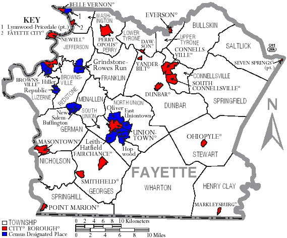
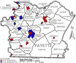 Map of Fayette County, Pennsylvania with Municipal Labels showing Cities and Boroughs (red), Townships (white), and Census-designated places (blue).
Under Pennsylvania law, there are four types of incorporated municipalities: cities, boroughs, townships, and, in at most two cases, towns. The following cities, boroughs and townships are located in Fayette County:
Cities
Boroughs
Townships
- Brownsville
- Bullskin
- Connellsville
- Dunbar
- Franklin
- Georges
- German
- Henry Clay
- Jefferson
- Lower Tyrone
- Luzerne
- Menallen
- Nicholson
- North Union
- Perry
- Redstone
- Saltlick
- South Union
- Springfield
- Springhill
- Stewart
- Upper Tyrone
- Washington
- Wharton
Census-designated places
Census-designated places are geographical areas designated by the U.S. Census Bureau for the purposes of compiling demographic data. They are not actual jurisdictions under Pennsylvania law. Other unincorporated communities, such as villages, may be listed here as well.
- Wickhaven
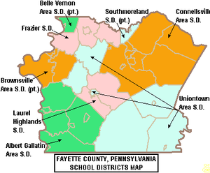 Map of Fayette County, Pennsylvania School Districts
Education
Colleges & Universities
- Penn State Fayette
Public School Districts
- Albert Gallatin Area School District
- Belle Vernon Area School District (also in Westmoreland County)
- Brownsville Area School District (also in Washington County)
- Connellsville Area School District
- Frazier School District
- Laurel Highlands School District
- Southmoreland School District (also in Westmoreland County)
- Uniontown Area School District
Private Schools
- All Saints Regional School - Masontown
- Apostolic Christian Academy - Dunbar
- Bible Baptist Academy - Uniontown
- Champion Christian School - Champion
- Chestnut Ridge Christian Academy - Uniontown
- Connellsville Area Catholic School - Connellsville
- Geibel Catholic High School - Connellsville
- Mount Carmel Christian School - Mount Pleasant
- Mount Moriah Christian School - Smithfield
- Mount Zion Christian Academy - Acme
- New Meadow Run Parochial School - Farmington
- Spring Valley School - Farmington
- St John Evangelist School - Uniontown
- St Mary (Nativity) School - Uniontown
- Verna Montessori School - Prittstown
Fixtures
- Fort Necessity is a reconstructed historic stockade that was originally built by George Washington to defend against an attack during the French and Indian War. Washington's loss at Fort Necessity was the only blemish on his military record. It is now operated as a national battlefield.[7]
- General Edward Braddock's Grave is across the highway from Fort Necessity. He was mortally wounded while attacking Fort Duquesne (at the "forks of the Ohio River" in present day Downtown Pittsburgh) during the French and Indian War. It is a unit of the national battlefield. Under an agreement with British government, the site of Braddock's grave is officially considered British soil.
- The National Road (also known as the Cumberland Road) bisects Fayette County. It was the first significant roadway to be paid for by the federal government, connecting Baltimore, Maryland to Vandalia, Illinois. US 40 follows the path of this historic toll road.
- Two historic fixtures from the National Road exist within Fayette County's borders. Searights Toll House is one of few remaining toll collection stops along the old route. The Washington Tavern, a unit of Fort Necessity National Battlefield, is a classic example of an early 19th century inn.
- The town of Perryopolis was designed by George Washington during his career as a surveyor. It includes a restored grist mill that once served as an (unsuccessful) business venture for the future president.
- Fallingwater, architect Frank Lloyd Wright's most famous home, is located atop a flowing waterfall in Stewart Township. His lesser known but equally impressive Kentuck Knob is also located within the same municipality.[8]
- Friendship Hill, the home of the little known but highly influential early 19th Century political figure Albert Gallatin, is maintained as a National Historic Site. [9]
- Fayette County's southern border is adorned with plaques that mark its significance as part of the Mason-Dixon Line
- A collection of waterfalls surrounding the Youghiogheny River Gorge are protected as part of Ohiopyle State Park.
- Laurel Ridge State Park contains an extensive hiking trail that traverses much of Pennsylvania's Appalachian foothills.
- The county contains the largest cave in Pennsylvania, Laurel Caverns, which is popular as both a tour and spelunking destination.
- A historic trading post that eventually was turned into a spectacular mansion is featured in Nemacolin Castle. The structure is well known for its connections to the Underground Railroad.
- The prestigious Nemacolin Woodlands Resort is located in rural Wharton Township. It features a five star hotel and has received a license for a slots casino.
- Mountainous western Fayette County is home to the Seven Springs Mountain Resort, which is the premier skiing destination for Greater Pittsburgh.
Notable Fayette Countians
- John Dickson Carr, mystery writer and three time Edgar Allan Poe Award winner
- Vinnie Colaiuta, world-renowned session and band drummer for a wide range of jazz, fusion, rock, funk, post bop, and other musical performers and groups
- Ernie Davis, 1961 Heisman Trophy Winner
- Fabian, 1960s pop musician
- Albert Gallatin, Secretary of the Treasury, U.S. House Majority leader, and founder of New York University
- Joe Hardy, founder of 84 Lumber, one of the country's largest privately owned companies
- Philander C. Knox, Secretary of State, U.S. Senator, and U.S. Attorney General
- Johnny Lujack, 1947 Heisman Trophy Winner
- George C. Marshall, 1953 Nobel Peace Prize Winner, Secretary of State, World War II Supreme Allied Commander, and author of the Marshall Plan
- Terry Mulholland, former Major League Baseball pitcher
- Chuck Muncie, former NFL running back
- Tamora Pierce, fantasy writer
- Edwin S. Porter, film pioneer and director of The Great Train Robbery
- Henry Miller Shreve, pioneering captain who opened the Mississippi River to steamboat navigation
- Saul Swimmer, documentary film maker best known for The Concert For Bangladesh; co-producer of The Beatles' Let It Be
- Sandy Stephens, the first African American quarterback for the University of Minnesota Golden Gophers, was born in Uniontown.
- Tory Epps, former NFL defensive lineman for the Atlanta Falcons and New Orleans Saints, was born and raised in Uniontown.
See also
- List of municipal authorities in Fayette County, Pennsylvania
- National Register of Historic Places listings in Fayette County, Pennsylvania
References
- ^ "Find a County". National Association of Counties. http://www.naco.org/Counties/Pages/FindACounty.aspx. Retrieved 2011-06-07.
- ^ http://patheoldminer.rootsweb.ancestry.com/fayecho1.html
- ^ http://factfinder2.census.gov
- ^ http://mapserver.lib.virginia.edu/
- ^ "American FactFinder". United States Census Bureau. http://factfinder.census.gov. Retrieved 2008-01-31.
- ^ Zlatos, Bill (May 12, 2009). "Poverty worse in Pa. than reported: study". Pittsburgh Tribune-Review. http://pittsburghlive.com/x/pittsburghtrib/news/s_624723.html. Retrieved May 13, 2009.
- ^ "Fort Necessity National Battlefield". National Park Service. http://www.nps.gov/fone/. Retrieved 2007-09-15.
- ^ "Fallingwater". Western Pennsylvania Conservancy. http://www.wpconline.org/fallingwaterhome.htm. Retrieved 2007-09-15.
- ^ "Friendship Hill National Historic Site (Estate of Albert Gallatin)". National Park Service. http://www.nps.gov/frhi/. Retrieved 2007-09-15.
External links
Municipalities and communities of Fayette County, Pennsylvania Cities 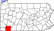
Boroughs Belle Vernon | Brownsville | Dawson | Dunbar | Everson | Fairchance | Fayette City | Markleysburg | Masontown | Newell | Ohiopyle | Perryopolis | Point Marion | Seven Springs‡ | Smithfield | South Connellsville | Vanderbilt
Townships Brownsville | Bullskin | Connellsville | Dunbar | Franklin | Georges | German | Henry Clay | Jefferson | Lower Tyrone | Luzerne | Menallen | Nicholson | North Union | Perry | Redstone | Saltlick | South Union | Springfield | Springhill | Stewart | Upper Tyrone | Washington | Wharton
CDPs Unincorporated
communitiesAcme | Adah | Farmington | Gans | Grindstone | Lake Lynn | Lemont Furnace | McClellandtown | Rowes Run | Star Junction | Whitsett | Wickhaven
Footnotes ‡This populated place also has portions in an adjacent county or counties
50 largest metropolitan statistical areas in the United States by population - New York
- Los Angeles
- Chicago
- Dallas–Fort Worth
- Philadelphia
- Houston
- Washington
- Miami
- Atlanta
- Boston
- San Francisco–Oakland
- Detroit
- Riverside–San Bernardino
- Phoenix
- Seattle
- Minneapolis–St. Paul
- San Diego
- St. Louis
- Tampa–St. Petersburg
- Baltimore
- Memphis
- Louisville
- Richmond
- Oklahoma City
- Hartford
- New Orleans
- Buffalo
- Raleigh
- Birmingham
- Salt Lake City
 Commonwealth of Pennsylvania
Topics - Cities
- Politics
- Government
- Delegations
- History
- Geography
- Geology
- Pennsylvanians
- State parks
- Symbols
- Visitor attractions
Metro areas Cities Largest
municipalities- Baldwin
- Berwick
- Bethel Park
- Brentwood
- Carlisle
- Chambersburg
- Columbia
- Darby
- Dunmore
- Elizabethtown
- Emmaus
- Ephrata
- Franklin Park
- Hanover
- Indiana
- Kingston
- Lansdale
- Lansdowne
- Monroeville
- Munhall
- Murrysville
- Norristown
- Penn Hills
- Phoenixville
- Plum
- Pottstown
- State College
- West Chester
- West Mifflin
- Whitehall
- Wilkinsburg
- Wyomissing
- Yeadon
Regions - Allegheny Mountains
- Allegheny National Forest
- Allegheny Plateau
- Atlantic Coastal Plain
- Blue Ridge
- Coal Region
- Cumberland Valley
- Delaware Valley
- Dutch Country
- Endless Mountains
- Happy Valley
- Laurel Highlands
- Lehigh Valley
- Main Line
- Northeast
- Northern Tier
- Northwestern
- Oil Region
- Pennsylvania Highlands
- Piedmont
- The Poconos
- Ridge and Valley
- South Central
- Susquehanna Valley
- Western
- Wyoming Valley
Counties - Adams
- Allegheny
- Armstrong
- Beaver
- Bedford
- Berks
- Blair
- Bradford
- Bucks
- Butler
- Cambria
- Cameron
- Carbon
- Centre
- Chester
- Clarion
- Clearfield
- Clinton
- Columbia
- Crawford
- Cumberland
- Dauphin
- Delaware
- Elk
- Erie
- Fayette
- Forest
- Franklin
- Fulton
- Greene
- Huntingdon
- Indiana
- Jefferson
- Juniata
- Lackawanna
- Lancaster
- Lawrence
- Lebanon
- Lehigh
- Luzerne
- Lycoming
- McKean
- Mercer
- Mifflin
- Monroe
- Montgomery
- Montour
- Northampton
- Northumberland
- Perry
- Philadelphia
- Pike
- Potter
- Schuylkill
- Snyder
- Somerset
- Sullivan
- Susquehanna
- Tioga
- Union
- Venango
- Warren
- Washington
- Wayne
- Westmoreland
- Wyoming
- York
Categories:- Pennsylvania counties
- Fayette County, Pennsylvania
- 1783 establishments in the United States
- Pittsburgh metropolitan area
- Populated places established in 1783


Wikimedia Foundation. 2010.