- Bedford County, Pennsylvania
-
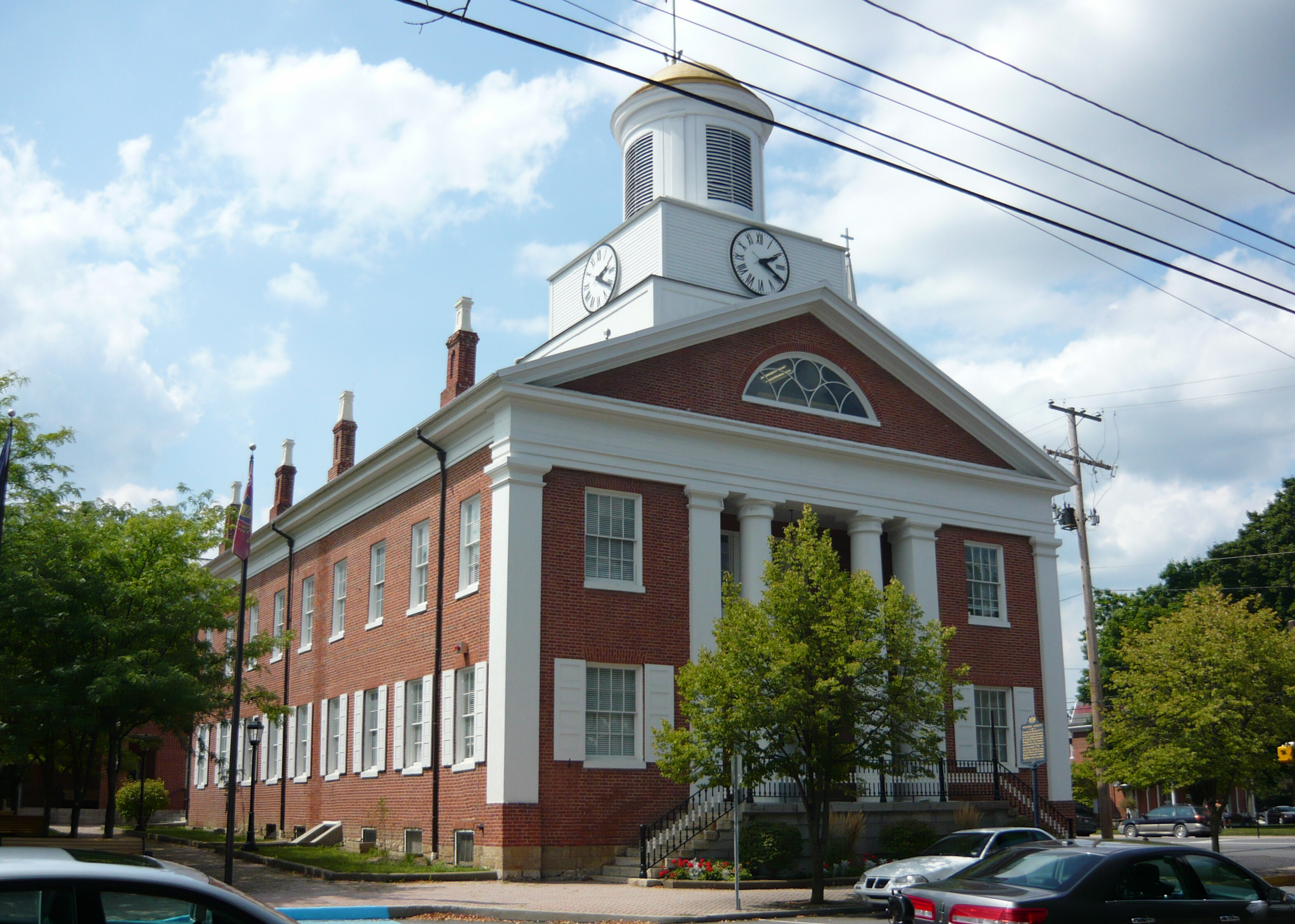
Bedford County, Pennsylvania 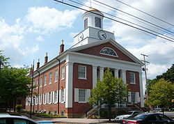 Bedford County Courthouse
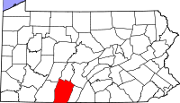
Location in the state of Pennsylvania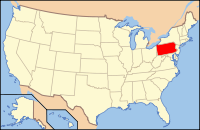
Pennsylvania's location in the U.S.Founded March 9, 1771 Seat Bedford Largest city Bedford Area
- Total
- Land
- Water
1,017 sq mi (2,634 km²)
1,015 sq mi (2,629 km²)
3 sq mi (8 km²), 0.28%Population
- (2010)
- Density
49,762
49/sq mi (18.9/km²)Website bedford.pacounties.org Bedford County is a county located in the U.S. state of Pennsylvania. As of the 2010 census, the population was 49,762. The county seat is Bedford. It is part of the Altoona, Pennsylvania, Metropolitan Statistical Area.
Contents
History
Robert MacRay opened the first trading post in Raystown (which is now Bedford) on the land that is now Bedford County in 1750. The settlers had a difficult time dealing with raids from Indians and the fighting between the French and the British.
In 1759, after the capture of Fort Duquesne in Allegheny County, a road was built between the fort (which was renamed to Fort Pitt) to the newly built Fort Bedford in Raystown. This road followed Indian trails and became "Forbes Road" which passed through Bedford and is now Route 30. When the Pennsylvania Turnpike was built, this interstate toll road became the main highway through Bedford County.
Bedford County was created on March 9, 1771 from part of Cumberland County and named in honor of the Fort Bedford.
The area quickly increased in population once safety became more established. The land with its lush farmland and woodland became an attractive site. It also formed an important center on the way to Pittsburgh and farther west of Pennsylvania. George Washington stayed in the county in response to the Whiskey Rebellion in 1794.
The Bedford Springs Hotel became an important site for the wealthy. Under President James Buchanan, the hotel became the summer White House. The U.S. Supreme Court met at the hotel once. It was the only time that the high court met outside of the Capital.
The 19th century featured a population boom in the county with the population doubling in size between 1870 and 1890. Railroads passing through the town connected the county with the mining industry. The story of the Lost Children of the Alleghenies originates from Blue Knob State Park in the county.
- A road in New Paris borough offers an example of the "Gravity hill" phenomenon.
 View from Glade Pike on Dry Ridge.
Law and Government
Pennsylvania State Senate
- John Eichelberger, Republican, Pennsylvania's 30th Senatorial District
Pennsylvania House of Representatives
- Dick L. Hess, Republican, Pennsylvania's 78th Representative District
- Carl Walker Metzgar, Republican, Pennsylvania's 69th Representative District
United States House of Representatives
- Bill Shuster, Republican, Pennsylvania's 9th congressional district
Geography
According to the U.S. Census Bureau, the county has a total area of 1,017 square miles (2,634.0 km2), of which 1,015 square miles (2,628.8 km2) is land and 3 square miles (7.8 km2) (0.28%) is water.
Adjacent counties
- Blair County (north)
- Huntingdon County (northeast)
- Fulton County (east)
- Allegany County, Maryland (southwest)
- Somerset County (west)
- Cambria County (northwest)
Significant Topographic Features
Transportation
Major Highways


 Interstate 70/Interstate 76 (PA Turnpike)
 Interstate 99
 U.S. Route 30
 U.S. Route 220
 State Route 26
 State Route 36
 State Route 56
 State Route 96
Airports
Bedford County Airport is a public use airport in Bedford County. It is owned by the Bedford County Airport Authority and is located four nautical miles (7.4 km) north of the central business district of the borough of Bedford, Pennsylvania.
Geology
 Blue Knob Mountain (3,146 ft)from HelixvilleMain article: Geology of Bedford County, Pennsylvania
Bedford County is situated along the western border of the Ridge and Valley physiographic province, which is characterized by folded and faulted sedimentary rocks of early to middle Paleozoic age. The northwestern border of the county is approximately at the Allegheny Front, a geological boundary between the Ridge and Valley Province and the Allegheny Plateau (characterized by relatively flat-lying sedimentary rocks of late Paleozoic age). (PA Geological Survey Map 13)
The stratigraphic record of sedimentary rocks within the county spans from the Cambrian Warrior Formation to the Pennsylvanian Conemaugh Group (in the Broad Top area). No igneous or metamorphic rocks of any kind exist within the county.
The primary mountains within the county (From west to east: Wills, Evitts, Dunning, and Tussey mountains) extend from the southern border with Maryland to the northeast into Blair County, and are held up by the Silurian Tuscarora Formation, made of quartz sandstone and conglomerate. Chestnut Ridge is a broad anticline held up by the Devonian Ridgeley Member of the Old Port Formation, also made of sandstone and conglomerate. Broad Top, located north of Breezewood, is a plateau of relatively flat-lying rocks that are stratigraphically higher, and thus younger (Mississippian and Pennsylvanian), than most of the other rocks within the county (Cambrian through Devonian). Broad Top extends into Huntingdon County to the north and Fulton County to the east.
The Raystown Branch of the Juniata River is the main drainage in the northern two-thirds of the county. The river flows to the east through the mountains within the county through several water gaps caused by a group of faults trending east-west through the central part of the county. The river then turns north and flows into Raystown Lake in Huntingdon County. The southern third of the county is drained by several tributaries of the Potomac River. Both the Potomac and Juniata rivers are part of the Chesapeake Bay Watershed.
Several limestone quarries exist in Bedford County, most of which are owned and operated by New Enterprise Stone and Lime Company. Quarry locations include Ashcom, New Paris, Kilcoin, and Sproul. [1].
Two coal fields exist within Bedford County. One is the Broad Top Field in the northeastern corner of the county, and the other is the Georges Creek Field along the southwestern border [2]. Both fields contain bituminous coal. There are abandoned mines in both areas and acid mine drainage is an environmental problem in the Broad Top area, where several fishless streams exist as a result of the discharge from the abandoned mines. [3].
Natural gas fields and storage areas exist in southeastern Bedford County, primarily within folded Devonian rocks south of Breezewood. Another deep gas field exists in the vicinity of Blue Knob on the border with Blair County to the north. (PA Geological Survey Map 10)
Demographics
Historical populations Census Pop. %± 1790 13,132 — 1800 12,039 −8.3% 1810 15,746 30.8% 1820 20,248 28.6% 1830 24,502 21.0% 1840 29,335 19.7% 1850 23,052 −21.4% 1860 26,736 16.0% 1870 29,635 10.8% 1880 34,929 17.9% 1890 38,644 10.6% 1900 39,468 2.1% 1910 38,879 −1.5% 1920 38,277 −1.5% 1930 37,309 −2.5% 1940 40,809 9.4% 1950 40,775 −0.1% 1960 42,451 4.1% 1970 42,353 −0.2% 1980 46,784 10.5% 1990 47,919 2.4% 2000 49,976 4.3% 2010 49,762 −0.4% [1][2] As of the census[3] of 2000, there were 49,984 people, 19,768 households, and 14,489 families residing in the county. The population density was 49 people per square mile (19/km²). There were 23,529 housing units at an average density of 23 per square mile (9/km²). The racial makeup of the county was 98.54% White, 0.36% Black or African American, 0.11% Native American, 0.29% Asian, 0.01% Pacific Islander, 0.16% from other races, and 0.54% from two or more races. 0.53% of the population were Hispanic or Latino of any race. 42.8% were of German, 17.4% American, 8.1% English and 8.1% Irish ancestry according to Census 2000.
There were 19,768 households out of which 30.70% had children under the age of 18 living with them, 61.70% were married couples living together, 7.70% had a female householder with no husband present, and 26.70% were non-families. 23.50% of all households were made up of individuals and 11.50% had someone living alone who was 65 years of age or older. The average household size was 2.50 and the average family size was 2.95.
In the county, the population was spread out with 23.60% under the age of 18, 7.20% from 18 to 24, 28.10% from 25 to 44, 24.60% from 45 to 64, and 16.50% who were 65 years of age or older. The median age was 40 years. For every 100 females there were 97.20 males. For every 100 females age 18 and over, there were 94.40 males.
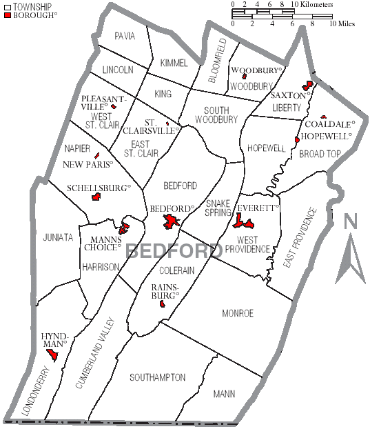
Municipalities
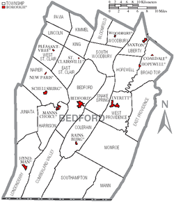 Map of Bedford County, Pennsylvania with Municipal Labels showing Boroughs (red) and Townships (white).
Under Pennsylvania law, there are four types of incorporated municipalities: cities, boroughs, townships, and, in only one case (Bloomsburg, Columbia County), towns. The following boroughs and townships are located in Bedford County:
Boroughs
Townships
- Bedford Township
- Bloomfield Township
- Broad Top Township
- Colerain Township
- Cumberland Valley Township
- East Providence Township
- East St. Clair Township
- Harrison Township
- Hopewell Township
- Juniata Township
- Kimmel Township
- King Township
- Liberty Township
- Lincoln Township
- Londonderry Township
- Mann Township
- Monroe Township
- Napier Township
- Pavia Township
- Snake Spring Township
- South Woodbury Township
- Southampton Township
- West Providence Township
- West St. Clair Township
- Woodbury Township
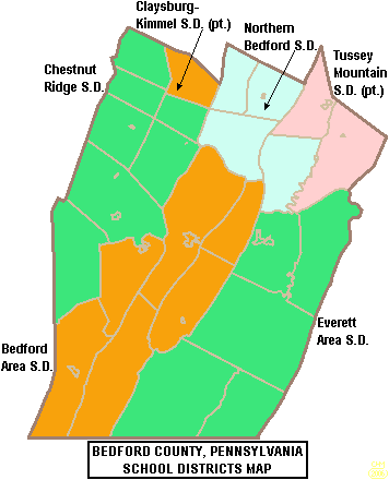
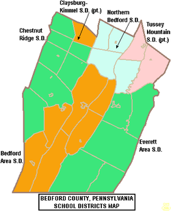 Map of Bedford County, Pennsylvania School Districts
Education
Public School Districts
- Bedford Area School District
- Chestnut Ridge School District
- Claysburg-Kimmel School District (also in Blair County)
- Everett Area School District
- Northern Bedford County School District
- Tussey Mountain School District (also in Huntingdon County)
Recreation
There are 3 Pennsylvania state parks in Bedford County.
- Blue Knob State Park site of the Blue Knob All Seasons Resort
- Shawnee State Park
- Warriors Path State Park
See also
- List of municipal authorities in Bedford County, Pennsylvania
- National Register of Historic Places listings in Bedford County, Pennsylvania
References
- "THE KERNEL OF GREATNESS: An Informal Bicentennial History of Bedford County (Pennsylvania)", by Bedford County Heritage Commission (Author), B/W Illus (Illustrator), 1971, ASIN B000KYDYOE
Municipalities and communities of Bedford County, Pennsylvania Boroughs Bedford | Coaldale | Everett | Hopewell | Hyndman | Manns Choice | New Paris | Pleasantville | Rainsburg | St. Clairsville | Saxton | Schellsburg | Woodbury

Townships Bedford | Bloomfield | Broad Top | Colerain | Cumberland Valley | East Providence | East St. Clair | Harrison | Hopewell | Juniata | Kimmel | King | Liberty | Lincoln | Londonderry | Mann | Monroe | Napier | Pavia | Snake Spring | South Woodbury | Southampton | West Providence | West St. Clair | Woodbury
Unincorporated
communitiesBreezewood | Chaneysville | Defiance | Loysburg | Mount Dallas | Osterburg | Riddlesburg | State Line
Categories:- Pennsylvania counties
- Bedford County, Pennsylvania
- States and territories established in 1771


Wikimedia Foundation. 2010.