- Montour County, Pennsylvania
-
Montour County, Pennsylvania 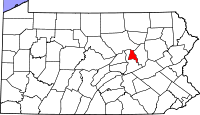
Location in the state of Pennsylvania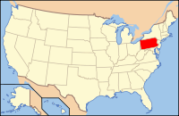
Pennsylvania's location in the U.S.Founded May 3, 1850 Seat Danville Largest city Danville Area
- Total
- Land
- Water
132 sq mi (342 km²)
131 sq mi (339 km²)
2 sq mi (5 km²), 1.17%Population
- (2010)
- Density
18,267
139/sq mi (53.8/km²)Website www.montourco.org Montour County is located in the U.S. state of Pennsylvania. In 2010, the county's population was 18,267. Its county seat is Danville[1]. It is named for Andrew Montour,[2] a prominent métis interpreter who served with George Washington during the French and Indian War. The county is part of the Bloomsburg–Berwick Micropolitan Statistical Area.
Contents
Geography
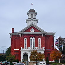 Montour County Courthouse in Danville.
According to the U.S. Census Bureau, the county has a total area of 132 square miles (352 km²), the smallest county in Pennsylvania, of which 131 square miles (369 km²) is land and 2 square miles (4 km²) (1.17%) is water.
Adjacent counties
- Lycoming County (north)
- Columbia County (east)
- Northumberland County (southwest)
Demographics
Historical populations Census Pop. %± 1850 13,239 — 1860 13,053 −1.4% 1870 15,344 17.6% 1880 15,468 0.8% 1890 15,645 1.1% 1900 15,526 −0.8% 1910 14,868 −4.2% 1920 14,080 −5.3% 1930 14,517 3.1% 1940 15,466 6.5% 1950 16,001 3.5% 1960 16,730 4.6% 1970 16,508 −1.3% 1980 16,675 1.0% 1990 17,735 6.4% 2000 18,239 2.8% 2010 18,267 0.2% [3][4] As of the census of 2000[5], there were 18,236 people, 7,085 households, and 4,817 families residing in the county. The population density was 140 people per square mile (54/km²). There were 7,627 housing units at an average density of 58 per square mile (23/km²). The racial makeup of the county was 96.67% White, 1.01% Black or African American, 0.07% Native American, 1.28% Asian, 0.38% from other races, and 0.59% from two or more races. 0.92% of the population were Hispanic or Latino of any race. 33.2% were of German, 13.2% American, 8.1% Irish, 6.6% English, 5.7% Italian and 5.6% Polish ancestry according to the 2000 census.
There were 7,085 households out of which 30.00% had children under the age of 18 living with them, 56.30% were married couples living together, 8.90% had a female householder with no husband present, and 32.00% were non-families. 28.00% of all households were made up of individuals and 12.00% had someone living alone who was 65 years of age or older. The average household size was 2.43 and the average family size was 2.98.
In the county, the population was spread out with 24.40% under the age of 18, 6.40% from 18 to 24, 28.20% from 25 to 44, 24.00% from 45 to 64, and 17.10% who were 65 years of age or older. The median age was 40 years. For every 100 females there were 90.50 males. For every 100 females age 18 and over, there were 86.00 males.
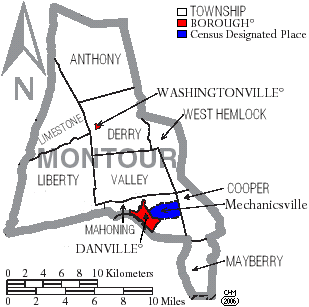
Municipalities
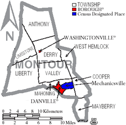 Map of Montour County, Pennsylvania with Municipal Labels showing Boroughs (red), Townships (white), and Census-designated places (blue).
Under Pennsylvania law, there are four types of incorporated municipalities: cities, boroughs, townships, and, in one case, towns. The following boroughs and townships are located in Montour County:
Boroughs
Townships
Census-designated place[6]
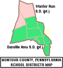
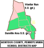 Map of Montour County, Pennsylvania Public School Districts
Education
Public School Districts
- Danville Area School District (also in Northumberland County)
- Warrior Run School District (also in Northumberland and Union Counties)
Private Schools
As reported by the Pennsylvania Department of Education - EdNA. April 2010.
- Breezy Meadow - Danville[7]
- Chillisquaque Valley Parochial School - Bloomsburg
- County Line Parochial School - Danville
- Creek Side School[8] - Turbotville
- Danville Mennonite School - Danville
- Limestone Mennonite Parochial School - Milton
- Ridgeview Amish School - Watsontown
- St Cyril Kindergarten - Danville
- St Joseph School - Danville
See also
- List of municipal authorities in Montour County, Pennsylvania
- National Register of Historic Places listings in Montour County, Pennsylvania
References
- ^ "Find a County". National Association of Counties. http://www.naco.org/Counties/Pages/FindACounty.aspx. Retrieved 2011-06-07.
- ^ Donehoo, Dr. George P. (1999) [1928] (PDF). A History of the Indian Villages and Place Names in Pennsylvania (Second Reprint Edition ed.). Lewisburg, Pennsylvania: Wennawoods Publishing. pp. 290. ISBN 1-889037-11-7. http://www.srbc.net/docs/IndianNamesDataChart.PDF. Retrieved 2007-03-07. "ISBN refers to a 1999 reprint edition, URL is for the Susquehanna River Basin Commission's web page of Native American Place names, quoting and citing the book. Some older sources say the county was named for Madame Montour, Andrew's mother."
- ^ http://factfinder2.census.gov
- ^ http://mapserver.lib.virginia.edu/
- ^ "American FactFinder". United States Census Bureau. http://factfinder.census.gov. Retrieved 2008-01-31.
- ^ Census-designated places are geographical areas designated by the U.S. Census Bureau for the purposes of compiling demographic data. They are not actual jurisdictions under Pennsylvania law. Other unincorporated communities, such as villages, may be listed here as well.
- ^ http://edna.ed.state.pa.us/Entity.asp?txtAUN=216470003&txtSchool=0&txtInst=43405
- ^ http://www.localschooldirectory.com/private-school/53237/PA
Municipalities and communities of Montour County, Pennsylvania Boroughs 
Townships CDP Unincorporated
communitiesCategories:- Pennsylvania counties
- Montour County, Pennsylvania
- 1850 establishments in the United States
- Bloomsburg-Berwick micropolitan area


Wikimedia Foundation. 2010.