- Lawrence County, Pennsylvania
-
Lawrence County, Pennsylvania  Lawrence County Courthouse
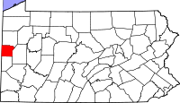
Location in the state of Pennsylvania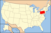
Pennsylvania's location in the U.S.Founded March 20, 1849 Seat New Castle Largest city New Castle Area
- Total
- Land
- Water
363 sq mi (940 km²)
361 sq mi (935 km²)
2 sq mi (5 km²), 0.63%Population
- (2010)
- Density
91,108
252/sq mi (97.4/km²)Website www.co.lawrence.pa.us Lawrence County is a county located in the U.S. state of Pennsylvania. In 2010, its population was 91,108. The county was added to the Pittsburgh Metropolitan Statistical Area in 2003. The county seat is New Castle[1].
Lawrence County was created on March 20, 1849, from parts of Beaver and Mercer counties. It was named after the USS Lawrence, Oliver Hazard Perry's original flagship at the Battle of Lake Erie during the War of 1812.
Contents
Geography
According to the U.S. Census Bureau, the county has a total area of 363 square miles (940.2 km2), of which 360 square miles (932.4 km2) is land and 2 square miles (5.2 km2) (0.63%) is water. Major waterways are the Shenango River, Neshannock Creek and the Mahoning River which form the Beaver River. Also, the Slippery Rock Creek and Connoquenessing Creak empty into the Beaver River.
Adjacent counties
- Mercer County (north)
- Butler County (east)
- Beaver County (south)
- Columbiana County, Ohio (southwest)
- Mahoning County, Ohio (west)
Government and politics
As of November 2008, there are 62,505 registered voters in Lawernce County [1].
- Democratic: 34,728 (55.56%)
- Republican: 22,509 (36.01%)
- Other Parties: 5,268 (8.43%)
County commissioners
- Dan Vogler, Chairman, Republican
- Bob Del Signore, Republican
- Steve Craig, Democrat
Other county officials
- Clerk of Courts and Prothonotary, Helen Morgan, Democrat
- Controller, David Gettings, Republican
- District Attorney, Joshua Lamancusa, Democrat
- Register of Wills and Recorder of Deeds, Janet Kalajainen, Democrat
- Sheriff, Perry Quahliero, Democrat
- Treasurer, Richard Rapone, Democrat
State Representatives
- Christopher Sainato, Democrat, 9th district
- Jaret Gibbons, Democrat, 10th district
- Michele Brooks, Republican, 17th district
State Senators
- Elder Vogel, Republican, 47th district
- Robert D. Robbins, Republican, 50th district
US Representative
- Jason Altmire, Democrat, 4th district
Demographics
Historical populations Census Pop. %± 1850 21,079 — 1860 22,999 9.1% 1870 27,298 18.7% 1880 33,312 22.0% 1890 37,517 12.6% 1900 57,042 52.0% 1910 70,032 22.8% 1920 85,545 22.2% 1930 97,258 13.7% 1940 96,877 −0.4% 1950 105,120 8.5% 1960 112,965 7.5% 1970 107,374 −4.9% 1980 107,150 −0.2% 1990 96,246 −10.2% 2000 94,639 −1.7% 2010 91,108 −3.7% [2][3] As of the census[4] of 2000, there were 94,643 people, 37,091 households, and 25,889 families residing in the county. The population density was 263 people per square mile (101/km²). There were 39,635 housing units at an average density of 110 per square mile (42/km²). The racial makeup of the county was 94.98% White, 3.61% Black or African American, 0.10% Native American, 0.27% Asian, 0.01% Pacific Islander, 0.19% from other races, and 0.84% from two or more races. 0.56% of the population were Hispanic or Latino of any race. 26.1% were of Italian, 21.7% German, 9.3% Irish, 6.8% English and 6.8% Polish ancestry according to Census 2000.
There were 37,091 households out of which 28.80% had children under the age of 18 living with them, 54.50% were married couples living together, 11.50% had a female householder with no husband present, and 30.20% were non-families. 27.00% of all households were made up of individuals and 14.40% had someone living alone who was 65 years of age or older. The average household size was 2.47 and the average family size was 3.00.
In the county, the population was spread out with 23.10% under the age of 18, 8.30% from 18 to 24, 25.70% from 25 to 44, 23.60% from 45 to 64, and 19.30% who were 65 years of age or older. The median age was 40 years. For every 100 females there were 90.60 males. For every 100 females age 18 and over, there were 86.90 males.
Municipalities
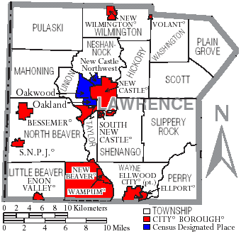
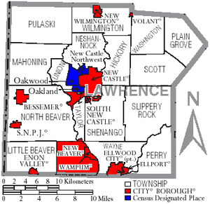 Map of Lawrence County, Pennsylvania with Municipal Labels showing Cities and Boroughs (red), Townships (white), and Census-designated places (blue).
Under Pennsylvania law, there are four types of incorporated municipalities: cities, boroughs, townships, and, in at most two cases, towns. The following cities, boroughs and townships are located in Lawrence County:
Cities
Boroughs
- Bessemer
- Ellport
- Ellwood City
- Enon Valley
Townships
- Hickory Township
- Little Beaver Township
- Mahoning Township
- Neshannock Township
- North Beaver Township
- Perry Township
- Plain Grove Township
- Pulaski Township
- Scott Township
- Shenango Township
- Slippery Rock Township
Census-designated places
Census-designated places are geographical areas designated by the U.S. Census Bureau for the purposes of compiling demographic data. They are not actual jurisdictions under Pennsylvania law. Other unincorporated communities, such as villages, may be listed here as well.
Other Communities
Various unincorporated communities that lie within and are part of official municipalities.
- Castlewood (Shenango Twp)
- Chewton (Wayne Twp)
- Eastbrook (Hickory Twp)
- Edinburg (Mahoning Twp)
- Energy (Slippery Rock Twp)
- Frizzleburg (Pulaski Twp)
- Harlansburg (Scott Twp)
- Hillsville (Mahoning Twp)
- Moravia (Taylor Twp)
- Mount Jackson (North Beaver Twp)
- New Bedford (Pulaski Twp)
- West Pittsburg (Taylor Township)
- Wurtemburg (Taylor Twp)
Education
 Map of Lawrence County, Pennsylvania Public School Districts
Public School Districts
- Blackhawk School District (part)
- Ellwood City Area School District (part)
- Laurel School District
- Mohawk Area School District
- Neshannock Township School District
- New Castle Area School District
- Shenango School District
- Union Area School District
- Wilmington Area School District (part)
Colleges
- Butler Community College Lawrence Crossing Campus
- Erie Business College
- Westminster College
Transportation
Airports
- New Castle Municipal Airport (Union Twp)
Public Transit
Major Roads
 Interstate 76
 Interstate 79
 Interstate 376
 Pennsylvania Route 18
 Pennsylvania Route 65
 Pennsylvania Route 388
 Pennsylvania Route 551
 U.S. Route 19
 U.S. Route 224
 U.S. Route 422
Recreation
Parks
- Cascade Park (New Castle)
- Ewing Park (Ellwood City)
- Gaston Park (New Castle)
- McConnells Mill State Park (Slippery Rock Twp)
- Pearson Park (Neshannock Twp)
- West Park Nature Center (Union Twp)
State Game Lands
- SGL 148 (New Beaver)
- SGL 150 (Pulaski Twp)
- SGL 151 (Washington Twp)
- SGL 178 (Neshannock Twp)
- SGL 216 (Scott Twp)
Trails
See also
- List of municipal authorities in Lawrence County, Pennsylvania
- National Register of Historic Places listings in Lawrence County, Pennsylvania
References
- ^ "Find a County". National Association of Counties. http://www.naco.org/Counties/Pages/FindACounty.aspx. Retrieved 2011-06-07.
- ^ http://factfinder2.census.gov
- ^ http://mapserver.lib.virginia.edu/
- ^ "American FactFinder". United States Census Bureau. http://factfinder.census.gov. Retrieved 2008-01-31.
External links
- Tourism - http://www.visitlawrencecounty.com/
- Government - http://www.co.lawrence.pa.us/
- Economic Development - http://www.lawrencecounty.com/
- Chamber of Commerce - http://www.lawrencecountychamber.com/
- Fishing - http://www.fish.state.pa.us/
- Hunting - http://www.pgc.state.pa.us/
- History - http://www.portal.state.pa.us/portal/server.pt/community/phmc_home/1426
Municipalities and communities of Lawrence County, Pennsylvania City 
Boroughs Bessemer | Ellport | Ellwood City‡ | Enon Valley | New Beaver | New Wilmington | S.N.P.J. | South New Castle | Volant | Wampum
Townships Hickory | Little Beaver | Mahoning | Neshannock | North Beaver | Perry | Plain Grove | Pulaski | Scott | Shenango | Slippery Rock | Taylor | Union | Washington | Wayne | Wilmington
CDPs Unincorporated
communitiesHarlansburg | Rose Point | West Pittsburg
Footnotes ‡This populated place also has portions in an adjacent county or counties
 Commonwealth of Pennsylvania
Topics - Cities
- Politics
- Government
- Delegations
- History
- Geography
- Geology
- Pennsylvanians
- State parks
- Symbols
- Visitor attractions
Metro areas Cities Largest
municipalities- Baldwin
- Berwick
- Bethel Park
- Brentwood
- Carlisle
- Chambersburg
- Columbia
- Darby
- Dunmore
- Elizabethtown
- Emmaus
- Ephrata
- Franklin Park
- Hanover
- Indiana
- Kingston
- Lansdale
- Lansdowne
- Monroeville
- Munhall
- Murrysville
- Norristown
- Penn Hills
- Phoenixville
- Plum
- Pottstown
- State College
- West Chester
- West Mifflin
- Whitehall
- Wilkinsburg
- Wyomissing
- Yeadon
Regions - Allegheny Mountains
- Allegheny National Forest
- Allegheny Plateau
- Atlantic Coastal Plain
- Blue Ridge
- Coal Region
- Cumberland Valley
- Delaware Valley
- Dutch Country
- Endless Mountains
- Happy Valley
- Laurel Highlands
- Lehigh Valley
- Main Line
- Northeast
- Northern Tier
- Northwestern
- Oil Region
- Pennsylvania Highlands
- Piedmont
- The Poconos
- Ridge and Valley
- South Central
- Susquehanna Valley
- Western
- Wyoming Valley
Counties - Adams
- Allegheny
- Armstrong
- Beaver
- Bedford
- Berks
- Blair
- Bradford
- Bucks
- Butler
- Cambria
- Cameron
- Carbon
- Centre
- Chester
- Clarion
- Clearfield
- Clinton
- Columbia
- Crawford
- Cumberland
- Dauphin
- Delaware
- Elk
- Erie
- Fayette
- Forest
- Franklin
- Fulton
- Greene
- Huntingdon
- Indiana
- Jefferson
- Juniata
- Lackawanna
- Lancaster
- Lawrence
- Lebanon
- Lehigh
- Luzerne
- Lycoming
- McKean
- Mercer
- Mifflin
- Monroe
- Montgomery
- Montour
- Northampton
- Northumberland
- Perry
- Philadelphia
- Pike
- Potter
- Schuylkill
- Snyder
- Somerset
- Sullivan
- Susquehanna
- Tioga
- Union
- Venango
- Warren
- Washington
- Wayne
- Westmoreland
- Wyoming
- York
Categories:- Pennsylvania counties
- Lawrence County, Pennsylvania
- Populated places established in 1849


Wikimedia Foundation. 2010.