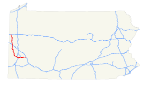
- Interstate 376
-
"Penn–Lincoln Parkway", "Parkway West", and "Parkway East" redirect here. For the highway known as Parkway North, see Interstate 279.
Interstate 376
Route information Maintained by PennDOT and Pennsylvania Turnpike Commission Length: 84.70 mi[1] (136.31 km) Existed: 1972, extended 2009 – present Major junctions West end:  I-80 near Hermitage
 US 422 in New Castle

 I-76 / Penna. Tpk. in Big Beaver
 Toll PA 576 near Pittsburgh International Airport
 I-79 near Pittsburgh
 I-279 in Pittsburgh
 I-579 in Pittsburgh
 US 30 in Wilkinsburg
East end:  I-76 / Penna. Tpk. / US 22 in Monroeville
Highway system Auxiliary route of the Interstate Highway System
Main • Auxiliary • BusinessRoads in Pennsylvania
Interstate • US • State • Legislative←  PA 374
PA 376  →
→Interstate 376 (I-376) is a major auxiliary route of the Interstate Highway System in the U.S. state of Pennsylvania, located entirely within the Allegheny Plateau. It runs from I-80 near Sharon south and east to a junction with the Pennsylvania Turnpike (I-76, its parent) in Monroeville, after having crossed the Turnpike earlier in its route. The route serves Pittsburgh, Pennsylvania and its surrounding areas, and is the main access road to Pittsburgh International Airport (PIT).[2] Within Allegheny County, the route runs along the majority of the Penn-Lincoln Parkway, known locally as the Parkway West and the Parkway East. The route is also known by several other names in various jurisdictions. It is currently the fifth-longest auxiliary Interstate route in the system, and second only to I-476 within the Commonwealth of Pennsylvania.
I-376 is signed east–west despite running north–south for nearly three-quarters of its length; however, it does run east–west through the majority of Allegheny County. This is due to the fact that when the route was first conceived, it was an east–west highway that only connected I-279 in Downtown Pittsburgh to the Turnpike in Monroeville. Despite the route's direction, it serves as a major artery through Pittsburgh's West End, with I-79 being the primary route through Pittsburgh's North Hills. Since its 2009 extension, the route has also served as access to Youngstown, Ohio (through both I-76 & I-80) and, ultimately, Akron, Ohio via I-76, Columbus, Ohio via I-76 & I-71, and Cleveland via I-80.[3]
A 16-mile (26 km) stretch, from exit 15 where I-376 ends its brief concurrency with U.S. Route 422 (US 422) to exit 31 where I-376 has its first intersection with Pennsylvania Route 51 (PA 51), is tolled and is maintained by the Pennsylvania Turnpike Commission, while the remainder of the highway is maintained by PennDOT. Near the airport, I-376 also has a business loop route (BL-376).
Contents
Route description
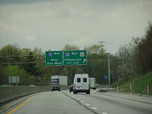 I-376 branches from I-76 near Monroeville; this view is looking westbound along Pennsylvania Turnpike/I-76.
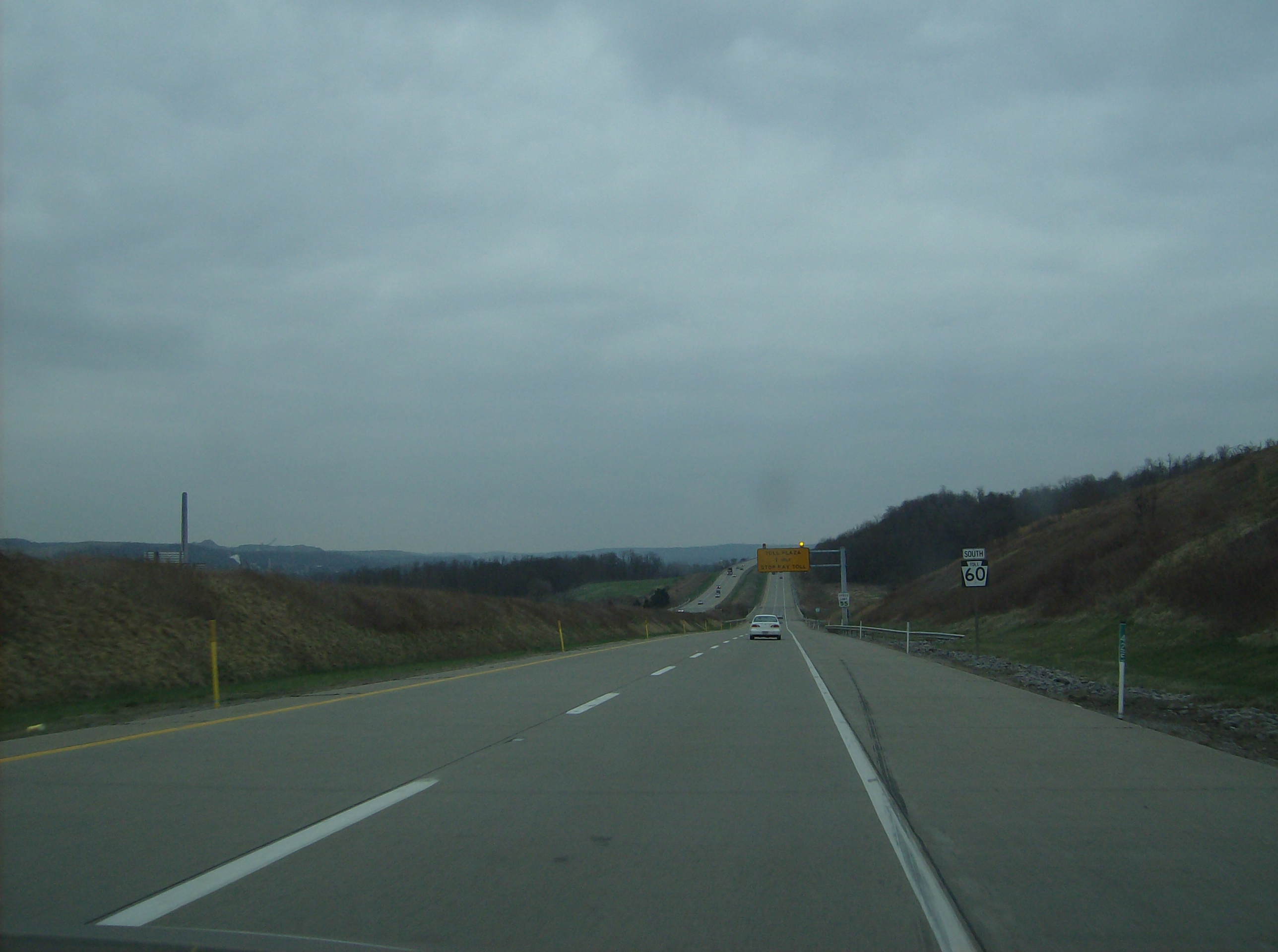
Since November 6, 2009, I-376 has had its western terminus at a cloverleaf interchange with I-80 located four miles east of Ohio within the Glaciated Allegheny Plateau. From there, it travels in a southern direction, following the former route of PA 60 along the Beaver Valley Expressway. Paralleling Pennsylvania Route 18, I-376 has its first official interchange with that state highway in West Middlesex, though as PA 760 it also meets that same route about a mile west-northwest of where the Interstate designation now begins (at I-80).
I-376 soon meets US 422 and forms an overlap with that highway along the west side of New Castle. After an interchange with US 224 in Union Township, I-376 eastbound widens to three (and eventually four) lanes in preparation of its split from US 422. Southwest of the city in Taylor Township, I-376 finally exits the roadway to the south with two lanes, leaving US 422 to circle around the southern edge of the city with the other two lanes. At this point, I-376 becomes a tolled freeway.
I-376 continues southward, still paralleled by PA 18, with both that road and the Beaver River to the east. Shortly after entering Beaver County near Koppel, the route interchanges with its parent I-76 – the Mainline of the Pennsylvania Turnpike – for the first time. It also has an indirect connection with Pennsylvania Route 351 at this interchange. Around this area, I-376 crosses into the Unglaciated Allegheny Plateau, where it remains for the remainder of its length. I-376 then passes to the east of West Mayfield and becomes a non-tolled highway again at its first interchange with Pennsylvania Route 51 in Chippewa Township, just west of Beaver Falls. The freeway then weaves through mountainous terrain, interchanging with Pennsylvania Route 68 in Vanport just before crossing the Vanport Bridge over the Ohio River. It then has its second interchange with PA 18 near Kobuta and continues south from there. I-376 passes to the west of Aliquippa before leaving Beaver County and entering Allegheny County.
Approaching Pittsburgh International Airport (PIT), the freeway diverges to the south onto the Southern Expressway, while Business Loop 376 (the former Business Route of PA 60) branches off to the east. I-376 circles around the southern edge of the airport, interchanging with the north edge of the Southern Beltway (Pennsylvania Route 576) at the main entrance to PIT then recombining with BL-376 shortly thereafter. Now traveling east-southeastward, the route features a recently rebuilt cloverleaf interchange with the Penn-Lincoln Parkway (US 22 and US 30) and Steubenville Pike (now the northern/western terminus of what remains of Pennsylvania Route 60) in Robinson Township. The two U.S. Highways join I-376 here, continuing east-southeastward bearing the Penn-Lincoln Parkway name, and soon reach an interchange with I-79. From that point eastward, along what was known for many years as I-279, the Parkway West freeway (now designated I-376) runs east-southeast through Rosslyn Farms and Carnegie before turning northeast and passing through Green Tree.
Entering the city of Pittsburgh along the former I-279, the Parkway West winds its way northeast to I-376's second interchange with PA 51 at Saw Mill Run Boulevard, which is also part of a spread-out and somewhat confusing series of ramps linking Banksville Road (US 19) and US 19 Truck. This junction, located just before the freeway passes under Mount Washington in the Fort Pitt Tunnel, features the infamous wrong-way concurrency of US 19 Truck. In addition to running concurrent with its parent route the wrong way, US 19 Truck is wrong-way concurrent onto itself, with both north and southbound traffic of US 19 Truck briefly running on I-376 eastbound.[4]
At the northeastern portal of the tunnel, I-376 emerges onto the double-deck Fort Pitt Bridge, crossing over the Monongahela River. There are single-lane westbound exit and eastbound entrance ramps connecting Carson Street to the freeway between the tunnel's portal and the bridge. Once across the river, the route touches down in Downtown Pittsburgh at the famous Golden Triangle in Point State Park. Here, the now-truncated I-279 begins, branching off to cross the twin Fort Duquesne Bridge and heading out through the North Side to eventually meet up with its parent Interstate. From this same complex interchange, which also includes access ramps for Liberty Avenue, the I-376/US 22/US 30 freeway (named the Penn-Lincoln Parkway East from this point on) turns east to follow the left upstream bank of the Monongahela River through the south side of the downtown area - as well that of as its adjacent neighborhoods, Soho and Oakland. The Parkway East eventually turns away from the river near the southwestern corner of Schenley Park and runs along that park's southern border before passing through Squirrel Hill Tunnel under Squirrel Hill.
Exiting the city of Pittsburgh near the southeastern corner of Frick Park, US 30 leaves the Parkway East freeway shortly thereafter at Pennsylvania Route 8 in the suburb of Wilkinsburg. I-376 continues a general easterly stretch through Churchill, Wilkins Township, Penn Hills, and finally Monroeville, where it eventually meets the toll plaza of the Pittsburgh Interchange leading back onto the Pennsylvania Turnpike's mainline. Just before that plaza, US 22 exits the freeway as well, joining the William Penn Highway (its original routing prior to the construction of the Penn-Lincoln Parkway). I-376 then finally reaches its eastern terminus, at its parent I-76.
History
Northern portion of the Beaver Valley Expressway and the New Castle Bypass
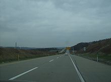
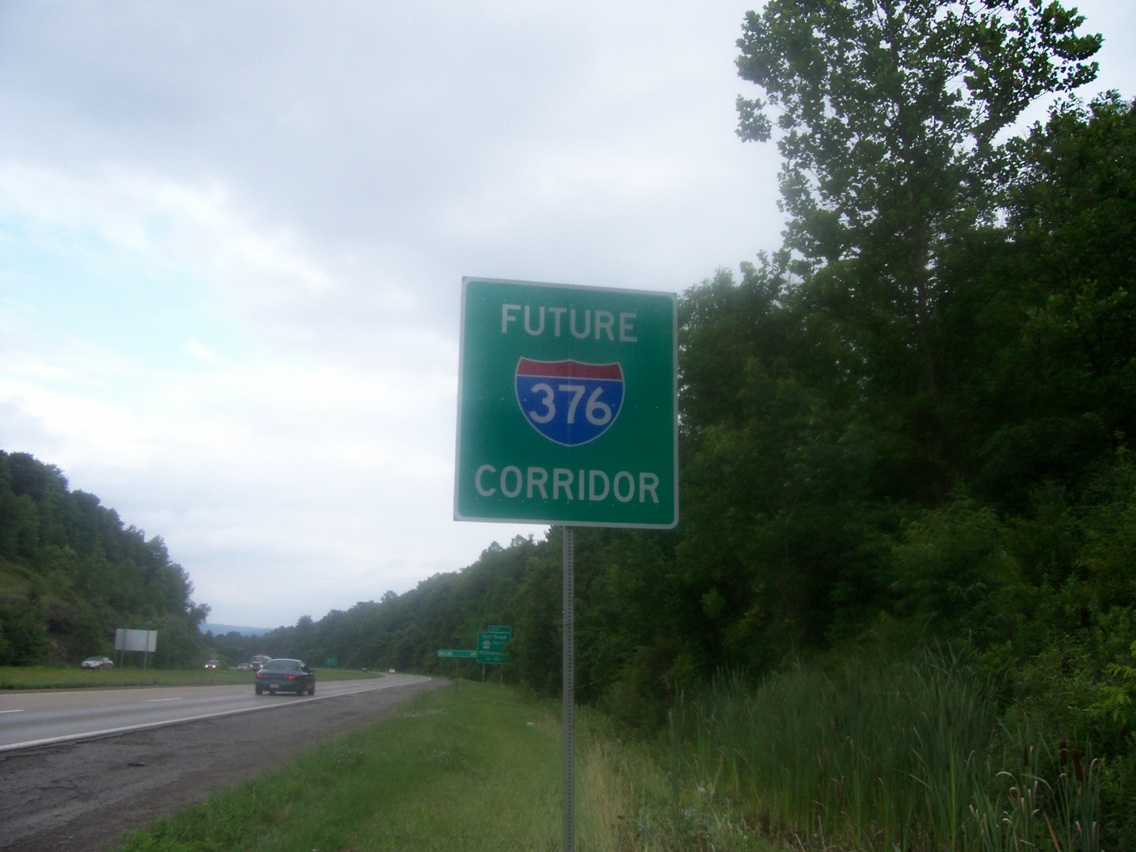
 Signs reading "Future I-376 Corridor" were posted along PA 60 from late April 2006 until 2010. This one was located on the New Castle Bypass.
The northern portion of the Beaver Valley Expressway opened in various stages between 1968 and 1977. The section of I-376 running concurrent with US 422 is officially known as the New Castle Bypass, which also bypasses the southern portion of New Castle after I-376 and US 422 split.
The first section that opened was in 1968 from the present-day exit 2 with PA 18 and where PA 18 intersects with the present-day PA 760 just north of I-80 and the western terminus of I-376.[5][6] This section would actually receive the PA 18 designation while the former alignment would receive a business route designation as PA 18 Business, since it served as a bypass of West Middlesex.[7] PA 18 Business was decommissioned in 1978 when PA 18 returned to the alignment (where it has remained to this day) when PA 60 was extended all the way to Hermitage.[8][9] PA 60 was eventually extended to Sharon in 1997, ending at US 62 Business.[10]
Until the James E. Ross Highway opened, the present-day exit 12A marked the southern terminus of the northern section of PA 60 as an "END 60" sign was located near the exit. The sign was removed when the first leg of the James E. Ross highway opened in 1991, and a "No re-entry this exit" sign has sat on the site since, due to exit 12A being an indirect connection to US 422 westbound without a direct re-entry ramp.
James E. Ross Highway
 A "Toll I-376" trailblazer on the tolled section of I-376.
One of the newest sections of I-376, it opened to PA 108 in 1991 and the remaining route in 1992 as the "missing link" between two sections of PA 60, when that route's designation was on the highway.[11] Previously, in order to continue on the highway, travelers had to use US 422, PA 168, PA 18, PA 251, and PA 51 before returning to the highway. Except for PA 251 (which passes over I-376 near the eastern toll plaza), I-376 has interchanges with all of the aforementioned routes.
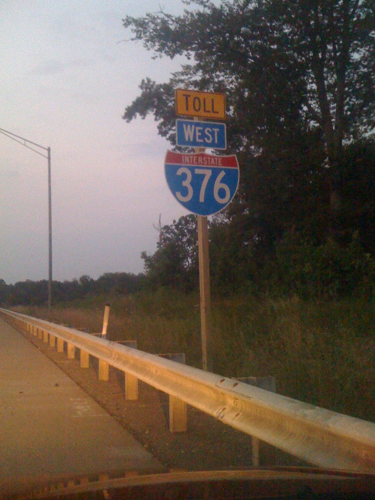
This section of I-376 is signed as "Toll I-376", with a black-on-yellow "Toll" sign above the I-376 trailblazer. This makes I-376 one of the first tolled Interstates with such a marker, which was a new addition to the 2009 edition of the Manual on Uniform Traffic Control Devices.[12]
Southern portion of the Beaver Valley Expressway and the Southern Expressway
Much like the northern section of the Beaver Valley Expressway, the southern portion of the Beaver Valley Expressway opened in various stages between 1971 and 1976.[5][13] The southern portion of the Beaver Valley Expressway and the Southern Expressway had the PA 60 designation for their entire lengths from their openings until the 2009 rebranding to I-376.
The Southern Expressway, which opened in 1992,[14][15] is the newest portion of I-376, and also has the distinction of being the last freeway to open in the Pittsburgh area that was not a toll road.[16] I-376 then merges with US 22 and US 30 at exit 60 south of Pittsburgh International Airport, which also marks the northern terminus of PA 60.
Parkway West
The first section of the Parkway West opened October 15, 1953, running from PA 60 (Steubenville Pike, then US 22/US 30) near Pittsburgh International Airport east to Saw Mill Run Boulevard (PA 51 and US 19). At Steubenville Pike, it connected to PA 60—the Airport Parkway—which had been built ca. 1950[17] as a high-speed surface road to provide access to the airport. The Fort Pitt Bridge opened June 19, 1959, and the Fort Pitt Tunnels completed the route on September 1, 1960. The final piece, from PA 60 west to the US 22/US 30 split at Imperial, opened in 1964.[18][19] Early plans for that section would have instead taken it from PA 60 where it splits with PA Route 60 Business northwest to US 30 near Campmeeting Road at Clinton.[20] The best-known landmark on I-376 is the Fort Pitt Tunnel and Bridge due to its "surprising" view of the Pittsburgh skyline.[citation needed]
The Parkway West has had the US 22 and US 30 designations for its entire history, using the West End Bypass (Pennsylvania Route 51) and Carson Street (Pennsylvania Route 837) as detours until the Fort Pitt Tunnel opened. From 1959 to 1964, I-70 also occupied this section east of PA 50 in Carnegie.[6] From 1963 to 1970, I-79 occupied the Parkway West, until it swapped positions with I-279. I-76 replaced I-79 afterwards until 1972, when its move to the Turnpike prompted I-279 to take its place. When I-376 was extended onto the Parkway West in 2009, I-279 was truncated to its current southern terminus at the former western terminus of I-376.[21]
Parkway East
The Parkway East opened June 5, 1953, from PA 885 (Bates Street) near the Hot Metal Bridge east through the Squirrel Hill Tunnel to US 22 Business (then US 22) at Churchill. In late 1956, it opened from the Boulevard of the Allies (then US 22/US 30) near the Birmingham Bridge east to Bates Street, with the eastbound lanes opening September 10 and westbound opening September 29. The other downtown sections opened in 1958 and 1959, and the extension east to the Pennsylvania Turnpike in Monroeville opened October 27, 1962.[1]
Like its western sister, the Parkway East has always had the US 22 and US 30 designations. Until 1961, it also carried the PA 80 designation until that route was decommissioned due to Pennsylvania needing the designation for I-80 to the north. From 1959 to 1964, the route carried the I-70 designation. When I-70 moved to its current alignment (replacing I-70S) in 1964, the route received the Interstate 76 designation.[22] Finally, in 1972, after I-76 west of Monroeville moved to the Pennsylvania Turnpike and replaced I-80S, the highway received the I-376 designation.
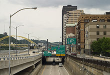
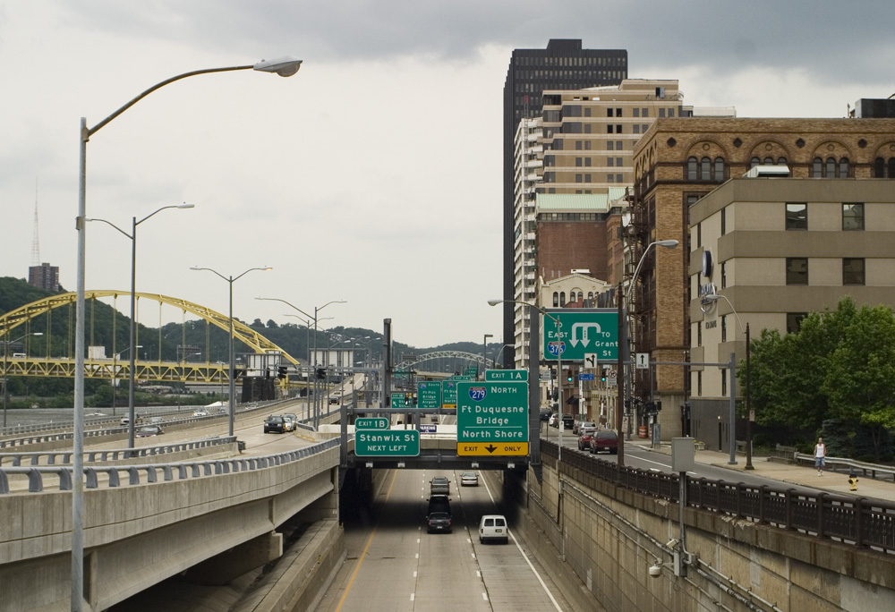
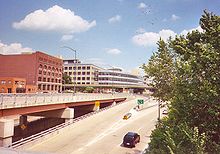 I-376 eastbound in downtown Pittsburgh.
2009 extensions
As part of the Safe, Accountable, Flexible, Efficient Transportation Equity Act: A Legacy for Users in 2005, the U.S. Congress had designated an expansion of I-376 past I-79 and along present day US 22/US 30 and PA 60 through the Pittsburgh International Airport and north to I-80 near Sharon, Pennsylvania. This was done because the Airport held the dubious distinction of being the only major airport in the United States without direct access to an Interstate highway.[2]
This routing required some major infrastructure work on US 22 west of Downtown Pittsburgh (particularly at the US 22/US 30 cloverleaf in Robinson Township) and safety improvements to PA 60; though both were limited access freeways before the extension, they were not up to Interstate Highway standards in all areas. The improvements to both the US 22/US 30 cloverleaf in Robinson Township and the Lawrence County leg of the route, as well as replacing all of the signs with the I-376 shield, were funded by the American Recovery and Reinvestment Act of 2009.[23]
The designation of I-279 from Downtown west through the Fort Pitt Tunnel to I-79 was officially dropped and replaced by that of I-376 on June 10, 2009.[24][21] I-279 still exists between I-376 in the Golden Triangle and I-79 in Franklin Park. On November 6, 2009, officials announced the initial transition was complete.[23]
On January 21, 2010, the remainder of the route except for the James E. Ross highway started receiving the I-376 signs. The stretch of PA 60 from I-80 in Shenango Township of Mercer County north past PA 18 (where the freeway terminates and the highway reverts to being a two lane arterial) to the former northern terminus of PA 60 in Sharon became PA 760.[25] On August 1, 2010, signage along Turnpike 60 was officially changed to Toll I-376,[26] and unlike other tolled highways with Interstate designation it is not grandfathered from Interstate standards. Having been built in the early 1990s, this section was already up to Interstate standards.
Despite PennDOT giving motorists over four years of advance notice on the I-376 extension, some local drivers were confused after the transition was complete, thinking that the I-376 extension was going to be an all-new highway instead of a renaming of PA 60.[3]
Exit list
County Location Mile[27] Old exit[28] New exit[28] Destinations Notes Mercer Shenango Township 0.0  PA 760 north – Sharon
Continuation beyond I-80 0.4 1 I-80 – Youngstown, MercerSigned as exits 1A (west) and 1B (east) 0.6 1C  PA 318 – Mercer, West Middlesex
Eastbound exit and westbound entrance 1.7 2  PA 18 – West Middlesex
Lawrence Pulaski Township 5.1 25 5  PA 208 – New Wilmington, Pulaski
Neshannock Township 9.3 24 9 To PA 18 / Mitchell RoadNeshannock Township–
Union Township12.5 12 US 422 west / Sampson Street (US 422 Bus. east) – YoungstownWest end of US 422 overlap; signed as exits 12A (west) and 12B (east) eastbound Union Township 13.4 13  US 224 (State Street) – Poland
Was reconfigured for both directions after I-376 designation; previously only served PA 224 west traffic, with a separate ramp for PA 224 east traffic 14.9 45 15 US 422 east – ButlerEast end of US 422 overlap; former exit 20; western terminus of Toll section North Beaver Township 16.3 43, 19 17  PA 108 – Mt. Jackson
Tolls collected at eastbound exit and westbound entrance 18.6 Mainline West Toll Plaza 18[29] 20.2 40, 18 20  PA 168 – Moravia
Tolls collected at eastbound entrance and westbound exit Beaver Big Beaver 26.0 33, 17 26  I-76 / Penna. Tpk. / PA 351 – Ohio, Harrisburg
No tolls collected at this exit 28.7 31, 16 29  PA 551 to PA 18 – Beaver Falls
Tolls collected at eastbound exit and westbound entrance Chippewa Township 30.9 Mainline East Toll Plaza 30[29] 31.2 29, 15 31  PA 51 – Chippewa
Eastern terminus of Toll section Brighton Township 36.0 14 36 Brighton Vanport Township 38.3 13 38  PA 68 – Beaver, Midland
Signed as exits 38A (west) and 38B (east) westbound Ohio River 38.6 Vanport Bridge Center Township 39.4 12 39 PA 18 – Monaca, Shippingport42.4 42 11 Center Hopewell Township 45.9 10 45 Aliquippa 48.7 9 48  PA 151 – Hopewell
Allegheny Findlay Township 51.2 8 50  I-376 Bus. east – Moon
Eastbound exit and westbound entrance 51.3 8 51 To I-376 Bus. east / Flaugherty Run Road – MoonWestbound exit and eastbound entrance 52.6 7 52 To US 30 – Clinton54.1 6 53 Toll PA 576 east to US 22 – Pittsburgh International Airport57.3 4 56 McClaren Road Moon Township 58.3 3  I-376 Bus. west / Orange Belt west – Moon
West end of Orange Belt overlap 59.4 2 58 Montour Run Road North Fayette Township 60.3 1 59 Robinson Town Centre Boulevard Robinson Township 60.9 60A US 22 west / US 30 west / Orange Belt east – WeirtonWest end of US 22/US 30 overlap; east end of Orange Belt overlap 61.0 60B  PA 60 south – Crafton
61.6 61 Ridge Road Robinson Township–
Collier Township63.0 62 Campbells Run Road Westbound exit and eastbound entrance Collier Township 64.2 1A 64A I-79 – Erie, WashingtonRosslyn Farms 65.4 1B 64B Rosslyn Farms Westbound exit and eastbound entrance Carnegie 65.9 Buses only (West Busway) Eastbound exit and westbound entrance 66.3 2 65  PA 50 west – Carnegie, Heidelberg
Green Tree 68.1 4A 67  PA 121 – Green Tree, Mount Lebanon, Crafton
Pittsburgh 69.0 4B 68 Parkway Center Drive Westbound exit and eastbound entrance 69.5 5A 69A  US 19 south (Banksville Road)
West end of US 19/US 19 Truck overlap; eastbound exit is via exit 69C 69.8 5B 69B 

US 19 Truck south / PA 51 south – UniontownWestbound exit is via exit 69A 69.9 5C 69C US 19 north / PA 51 north – West EndEast end of US 19 overlap; eastbound exit and westbound entrance 70.0 Fort Pitt Tunnel under Mount Washington 69.9 5C 69C  PA 837 to PA 51 – West End
Westbound exit and eastbound entrance 70.6 Fort Pitt Bridge over the Monongahela River 70.8 6B 70A Boulevard of the Allies, Liberty Avenue – Mellon Arena Eastbound exit and westbound entrance 70.9 6C 70B Fort Duquesne Boulevard – Convention Center, Strip District Eastbound exit and westbound entrance 71.0 1A 70C 
I-279 / US 19 Truck north – Fort Duquesne Bridge, North ShoreEast end of US 19 Truck overlap 71.1 1B, 1[5] 70D Stanwix Street No eastbound exit 71.3 1C 71A Grant Street 72.0 1D 71B Second Avenue Westbound exit only 72.8 2A 72A Forbes Avenue – Oakland Eastbound exit and westbound entrance 72.8 2B 72B  To I-579 (Crosstown Blvd) / PA 885 north (Boulevard of the Allies) / Liberty Bridge
Westbound exit and eastbound entrance; access to I-579 and Liberty Bridge is via Boulevard of the Allies, which is listed between them on overhead signs; no PA-885 shield is shown 73.7 3 73 PA 885 (Bates Street) – Oakland, GlenwoodWestbound exit and eastbound entrance; signed as exits 73A (south) and 73B (north) 75.3 5 74  Blue Belt – Squirrel Hill, Homestead
75.6 Squirrel Hill Tunnel under Squirrel Hill Swissvale–
Edgewood77.1 7 77 Edgewood, Swissvale Wilkinsburg 78.7 8A 78A US 30 east – Forest HillsEast end of US 30 overlap; no westbound exit 78.9 8B 78B  PA 8 north – Wilkinsburg
Churchill 79.6 9 79A Greensburg Pike Eastbound exit and westbound entrance 80.3 10A 79B  PA 130 – Churchill
80.9 10B 80 
US 22 Bus. east – Monroeville, Wilkins TownshipEastbound exit and westbound entrance Penn Hills 81.5 11 81 
 PA 791 north / Yellow Belt – Penn Hills
Monroeville 84.9 14A 84A  PA 48 south / Orange Belt – Monroeville
Eastbound exit and westbound entrance 85.1 14B 84B Orange Belt – PlumEastbound exit and westbound entrance 85.2 16
US 22 Bus. west – MonroevilleWestbound exit and eastbound entrance 85.2 17[5] US 22 east – Murrysville85.3 15 I-76 / Penna. Tpk.Eastbound exit and westbound entrance 1.000 mi = 1.609 km; 1.000 km = 0.621 mi Business Loop 376
Interstate 376 Business
Location: Allegheny County, Pennsylvania Existed: 2009–present 
Business Loop 376 (BL-376), known locally as the Airport Parkway, is a 6-mile Interstate Business Loop in Moon Township and Findlay Township, Pennsylvania. Its western terminus is at I-376 and Flaugherty Run Road (Exits 50 and 51) north of Pittsburgh International Airport (PIT). Its eastern terminus is at I-376's Exit 57, southeast of the PIT airport.
Before November 6, 2009, and after the Southern Expressway was completed in 1992, this road was known as Pennsylvania Route 60 Business.[15] Prior to that, this route had the regular PA 60 designation.[6][30] Much of the road is up to freeway standards, but several signaled at-grade intersections remain, making this multi-lane divided road a true expressway (unlike many of Pennsylvania's freeways, which are often misleadingly named using the suffix Expressway). Along with the business loop of Interstate 83 in York, Pennsylvania, BL-376 is one of only two business Interstate routes found in the Commonwealth of Pennsylvania.
References
- ^ a b Kitsko, Jeffrey J. (March 17, 2010). "Interstate 376". Pennsylvania Highways. http://www.pahighways.com/interstates/I376.html. Retrieved August 20, 2011.[unreliable source?]
- ^ a b "Some local roads to get I-376 designation". Pittsburgh Business Times. October 17, 2005. http://pittsburgh.bizjournals.com/pittsburgh/stories/2005/10/17/daily4.html.
- ^ a b "Confusion Lingers Over the New Interstate 376". Boardman Township, OH: WKBN-TV. June 4, 2010. http://www.wkbn.com/content/news/local/story/Confusion-Lingers-Over-the-New-Interstate-376/FrQIIiJURkS3V8kIBKKMaw.cspx. Retrieved June 8, 2010.
- ^ Reichard, Timothy. "I-279/US 19/Truck US 19/US 22/US 30 Multiplexes". Central PA/MD Roads. http://www.m-plex.com/roads/pamplex/mp_i279_us19_trkus19_us22_us30.html. Retrieved August 20, 2011.[unreliable source?]
- ^ a b c d Pennsylvania Department of Highways (1970) (PDF). Official Map of Pennsylvania (Map). ftp://ftp.dot.state.pa.us/public/pdf/BPR_pdf_files/Maps/Statewide/Historic_OTMs/1970fr.pdf. Retrieved April 13, 2010.
- ^ a b c Pennsylvania Department of Highways (1960) (PDF). Official Map of Pennsylvania (Map). ftp://ftp.dot.state.pa.us/public/pdf/BPR_pdf_files/Maps/Statewide/Historic_OTMs/1960fr.pdf. Retrieved April 13, 2010.
- ^ Kitsko, Jeffrey J. (March 17, 2010). "PA 1–PA 50". Pennsylvania Highways. http://www.pahighways.com/state/PA1-50.html#BUSPA18. Retrieved August 20, 2011.[unreliable source?]
- ^ Pennsylvania Department of Transportation (1980) (PDF). Commonwealth of Pennsylvania Official Transportation Map (Map). ftp://ftp.dot.state.pa.us/public/pdf/BPR_pdf_files/Maps/Statewide/Historic_OTMs/1980fr.pdf. Retrieved April 13, 2010.
- ^ Pennsylvania Department of Transportation (1987) (PDF). General Highway Map—Mercer County, Pennsylvania (Map). ftp://ftp.dot.state.pa.us/public/pdf/BPR_PDF_FILES/Maps/Type_10_GHS_Historical_Scans/Mercer_1987.pdf. Retrieved April 13, 2010.
- ^ Pennsylvania Department of Transportation (1997) (PDF). General Highway Map—Mercer County, Pennsylvania (Map). ftp://ftp.dot.state.pa.us/public/pdf/BPR_PDF_FILES/Maps/Type_10_GHS_Historical_Scans/Mercer_1997.pdf. Retrieved April 13, 2010.
- ^ Staff (November 19, 1992). "Route 60: Toll road completes an unfinished dream" (Editorial). The Beaver County Times: p. A6. http://news.google.com/newspapers?id=SLYiAAAAIBAJ&sjid=CLUFAAAAIBAJ&dq=beaver%20valley%20expressway&pg=2399%2C4736539. Retrieved April 14, 2010.
- ^ Staff (August 1, 2011). "Standard Highway Signs and Markings (SHSM) Interim Releases for New and Revised Signs". Manual on Uniform Traffic Control Devices. Federal Highway Administration. http://mutcd.fhwa.dot.gov/shsm_interim/index.htm. Retrieved August 20, 2011.
- ^ Citgo (1971). Pennsylvania (Map). Cartography by H.M. Gousha Company (1971 ed.).
- ^ Donovan, Sandra Fischione (August 28, 1990). "Casey flying high over expressway". The Beaver County Times: pp. A1, A8. http://news.google.com/newspapers?id=oLQiAAAAIBAJ&sjid=E7UFAAAAIBAJ&dq=southern%20expressway%20pittsburgh&pg=2869%2C5392975. Retrieved April 14, 2010.
- ^ a b Thorner, Jim (September 16, 1992). "Airport Expressway is born". The Weekly Times (The Beaver County Times): p. 1. http://news.google.com/newspapers?id=GbsiAAAAIBAJ&sjid=FLUFAAAAIBAJ&dq=airport%20expressway%20pittsburgh&pg=2257%2C4243752. Retrieved April 14, 2010.
- ^ Kitsko, Jeffrey J. (January 29, 2010). "Southern Expressway". Pittsburgh Highways. http://pittsburgh.pahighways.com/expressways/sexpressway.html. Retrieved August 20, 2011.[unreliable source?]
- ^ Staff (2009). "Database Search". National Bridge Inventory. Federal Highway Adminstration. http://nationalbridges.com/. Retrieved August 20, 2011.
- ^ Kitsko, Jeffrey J. (April 12, 2010). "Interstate 279". Pennsylvania Highways. http://www.pahighways.com/interstates/I279.html. Retrieved August 20, 2011.[unreliable source?]
- ^ Kitsko, Jeffrey J. (April 12, 2010). "US 22: William Penn Highway". Pennsylvania Highways. http://www.pahighways.com/us/US22.html. Retrieved August 20, 2011.[unreliable source?]
- ^ Pennsylvania Department of Highways (1950) (PDF). General Highway Map—Allegheny County, Pennsylvania (Map). ftp://ftp.dot.state.pa.us/public/pdf/BPR_PDF_FILES/Maps/Type_10_GHS_Historical_Scans/Allegheny_1950_Sheet_1.pdf. Retrieved August 20, 2011.
- ^ a b Schmitz, Jon (June 11, 2009). "Roads unite to form new Interstate 376". Pittsburgh Post-Gazette. http://www.post-gazette.com/pg/09162/976662-147.stm. Retrieved June 12, 2009.
- ^ Weingroff, Richard (April 07, 2011). "Was I-76 Numbered to Honor Philadelphia for Independence Day, 1776?". Ask the Rambler. http://www.fhwa.dot.gov/infrastructure/i76.cfm. Retrieved August 20, 2011.
- ^ a b Schmitz, Jon (November 6, 2009). "Highway now I-376 from Monroeville to Mercer". Pittsburgh Post-Gazette. http://www.post-gazette.com/pg/09310/1011377-455.stm?cmpid=latest.xml. Retrieved August 20, 2011.
- ^ "PennDOT Begins Sign Work to Convert Parkway West (I-279) to I-376" (Press release). Pennsylvania Department of Transportation District 11. June 10, 2009. http://www.dot.state.pa.us/penndot/districts/district11.nsf/37fc68a0aa7b94e9852570a70047899c/fe6cdfe66974764c852575d1004590a9?OpenDocument. Retrieved June 12, 2009.
- ^ Pennsylvania Department of Transportation (2010) (PDF). Mercer County, Pennsylvania Highway Map (Map). ftp://ftp.dot.state.pa.us/public/pdf/BPR_pdf_files/Maps/GHS/Roadnames/mercer_GHSN.PDF. Retrieved April 14, 2010.
- ^ "Effective August 1 New Signage Marks Turnpike 60 Conversion to I-376" (Press release). Pennsylvania Turnpike Commission. July 26, 2010. http://www.paturnpike.com/press/2010/20100726160344.htm. Retrieved July 30, 2010.
- ^ Google, Inc. Google Maps – Overview Map of I-376 (Map). Cartography by Google, Inc. http://maps.google.com/maps?saddr=Unknown+road&daddr=40.4432663,-79.8554494+to:40.5732879,-80.2848301+to:I-376+W&hl=en&sll=40.511711,-79.899445&sspn=0.50272,0.465546&geocode=FfoSaQId4Pk--w%3BFYIdaQIdp4A9-ykHpTCBPew0iDGg3KXe-TzFig%3BFWcZawIdYvM2-yl3Nuskc2g0iDH1YZJy5ZubiA%3BFSpkdAIdao40-w&mra=dme&mrsp=0&sz=11&via=1,2&vpsrc=0&z=11. Retrieved August 20, 2011.
- ^ a b Staff (August 19, 2009). "I-376 Corridor New Exit Numbers" (PDF). Pennsylvania Department of Transporation District 11-0. ftp://ftp.dot.state.pa.us/public/Districts/District11/traffic/I-376_Exits.pdf. Retrieved November 2009.
- ^ a b New Signage Marks Turnpike 60 Conversion to I-376 Pennsylvania Turnpike Commission 2010-07-02
- ^ Sun Oil Company (1964). Pennsylvania (Map). Cartography by H.M. Gousha Company (1964–65 ed.).
External links
Auxiliary routes of Interstate 76 
Interstate Highways in Pennsylvania Current Unbuilt 695 • 895Former Future Pennsylvania Turnpike Commission Completed highways Mainline Turnpike • Northeast Extension • James E. Ross Highway • Amos K. Hutchinson Bypass (Turnpike 66)
Partially-completed highways Tunnels Aborted expansion plans Historical Tolling systems Categories:- Interstate 70
- Three-digit Interstate Highways
- Interstate Highways in Pennsylvania
- Transportation in Pittsburgh, Pennsylvania
- Lincoln Highway
- U.S. Route 30
- Interstate 76 (east)
- Tolled sections of Interstate Highways


Wikimedia Foundation. 2010.