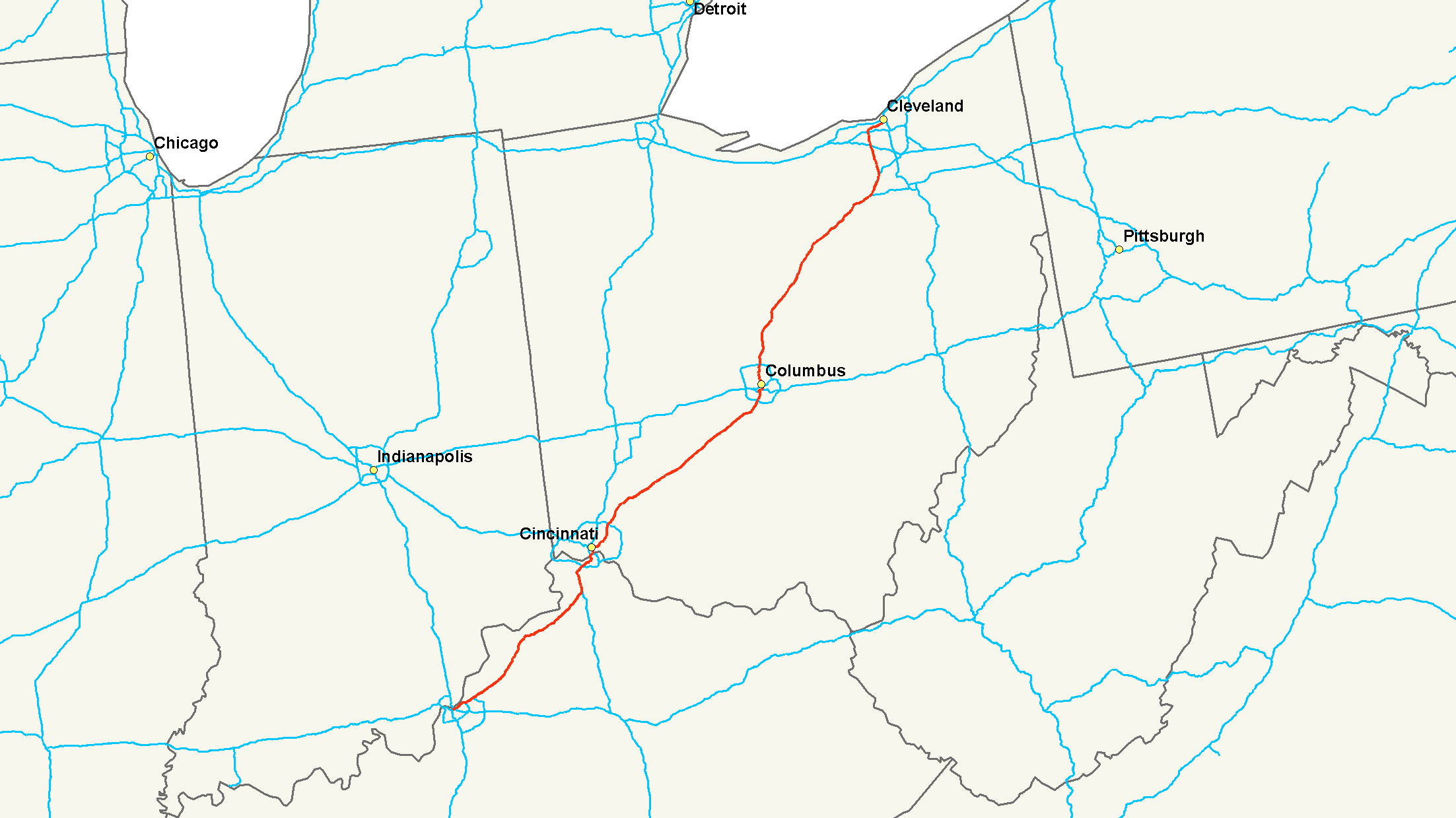
- Interstate 71
-
Interstate 71

Route information Maintained by Kentucky Transportation Cabinet and Ohio DOT Length: 343.78 mi[1][2] (553.26 km) Major junctions South end: 
 I-64 / I-65 in Louisville, KY
 I-75 near Cincinnati, Ohio
 I-70 in Columbus, OH
 I-76 in Seville, OH

 I-80 / Ohio Tpk. in Strongsville, OH
North end: 
 I-90 / I-490 in Cleveland, OH
Highway system Main route of the Interstate Highway System
Main • Auxiliary • Business←  KY 70
KY 70KY KY 72  →
→← I-70OH SR 72  →
→Interstate 71 (I-71) is an Interstate Highway in the Great Lakes/Midwestern and Southeastern region of the United States. Its southern terminus is at an interchange with Interstate 64 and Interstate 65 (the Kennedy Interchange) in Louisville, Kentucky. Its northern terminus is at an interchange with Interstate 90 in Cleveland, Ohio. I-71 runs concurrently with Interstate 75 from a point about twenty miles (30 km) south of Cincinnati, Ohio into downtown Cincinnati. Almost three quarters of the route lies east of I-75, thereby putting it out of its proper place in the Interstate grid.
While I-71 is designated a north–south highway, it is a major east–west route for cross-country traffic. It links I-80 and I-90 to I-70, and ultimately (via I-65) links to I-40.[citation needed]
Contents
Route description
Lengths mi[3] km KY 97.42 156.78 OH 248.15 399.36 Total 345.57 556.14 Kentucky
In Kentucky, I-71 begins east of Downtown Louisville at the Kennedy Interchange, where it meets I-64 and I-65. This interchange is sometimes called "Spaghetti Junction". From Louisville, it roughly follows the Ohio River in a diagonal path toward Northern Kentucky. Between Louisville and Cincinnati, I-71 is largely a two-lane highway, except for a couple of miles in Sparta in which it runs three lanes each way. I-71 merges with Interstate 75 near Walton and intersects Interstate 275, the Cincinnati beltway. After passing through Covington, the freeway crosses the Ohio River via the lower level of the Brent Spence Bridge and continues into Cincinnati.
Ohio
In Cincinnati, I-71 splits immediately from I-75 and heads due east onto Fort Washington Way, where it continues through downtown Cincinnati concurrently with US-50 for less than a mile. Just east of downtown, US-50 splits from I-71 and continues east; I-71 bends north and receives Interstate 471, a spur from southeast of the city. I-71 then heads in a general northeast direction through urban Cincinnati and into its surrounding suburbs. After another interchange with the Interstate 275 beltway, the freeway leaves the metropolitan area and heads towards Columbus. It continues northeast until it reaches South Lebanon, Ohio, where it begins cutting east across the flat plains of southwest Ohio. The freeway crosses the Little Miami River on the Jeremiah Morrow Bridge, which is a continuous truss bridge and the tallest bridge in Ohio at 239 feet above the river. I-71 heads towards Columbus then intersects with the bypass I-270 before heading north into urban Columbus, where it junctions I-70 and exits out of Columbus. The highway continues north until near Delaware, where it again turns northeast. Beginning its path to Cleveland, I-71 enters the rolling farm country on the edges of the Allegheny Plateau. It continues in this fashion to Lodi/Westfield Center and its junction with I-76. Heading north to Medina, it meets the terminus of I-271. The highway then continues north into urban Cuyahoga County and Cleveland's suburbs, intersecting the Ohio Turnpike/I-80. Passing Cleveland Hopkins International Airport, I-71 meets I-480 and enters Cleveland's west side, continuing on to downtown. It junctions with State Route 176 and terminates at Interstate 90 on the Innerbelt.
History
Ohio
Much of Interstate 71 in Ohio was intended to be State Route 1. State Route 1 was originally planned in the 1950s as a second Ohio Turnpike extending southwest to northeast across the state. It was planned to run from Cincinnati to Conneaut and connect with an extension built across the panhandle of Pennsylvania to the New York State Thruway. As the highway was being planned, the Federal Aid Highway Act of 1956 was enacted, and the project was converted from a toll road to a freeway. It was designated as State Route 1, since the Interstate Highway numbering system had not yet been implemented. Portions of the freeway began to be completed and opened in 1959 with the new Interstate Highway funding, and they were marked as State Route 1 as well as with their new Interstate Highway number. Since large gaps existed along the corridor where no freeway had yet been completed, existing two-lane or four-lane highways were also designated as State Route 1 in order to complete the route.
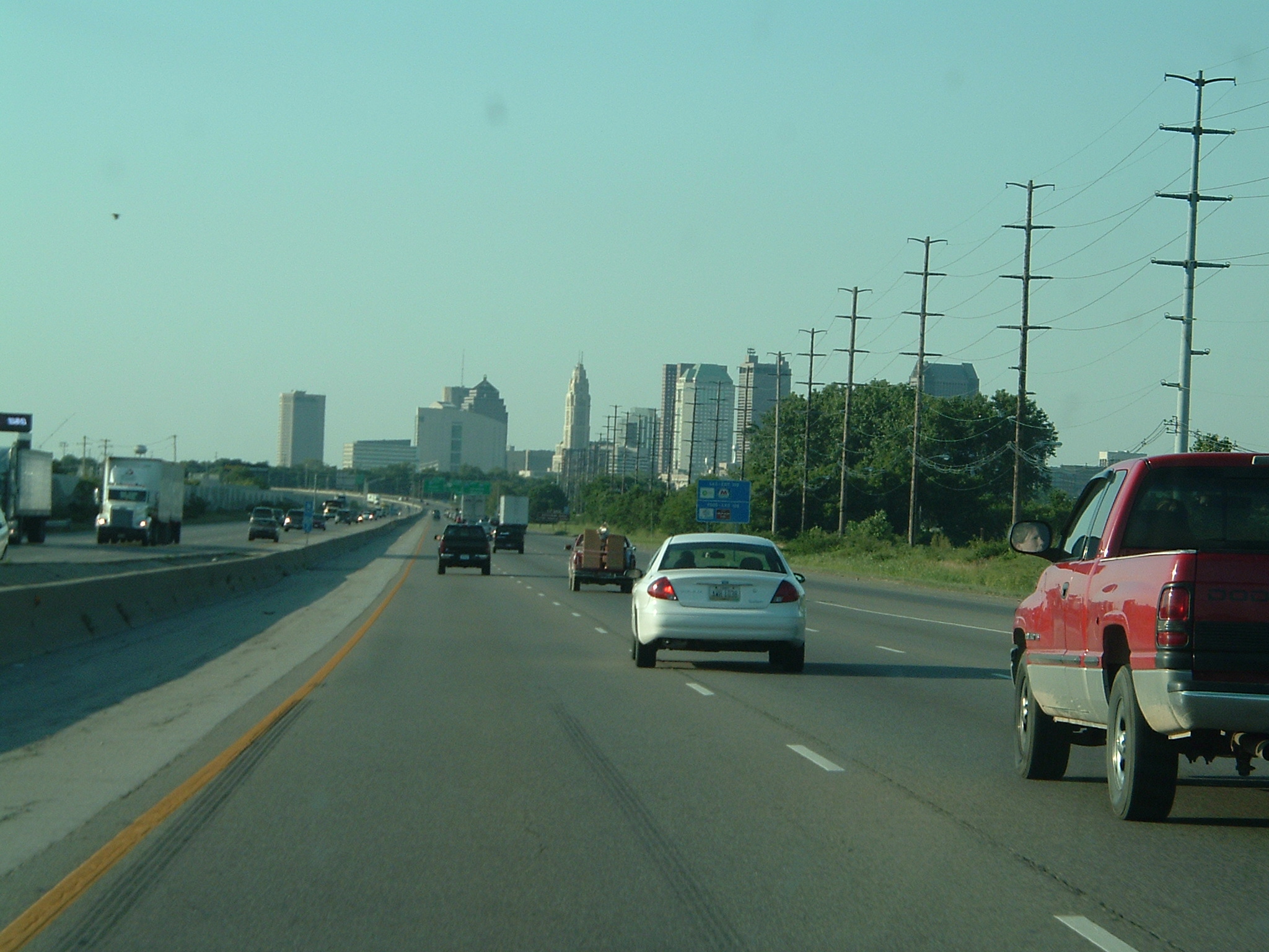
 Heading northbound into Columbus from the south
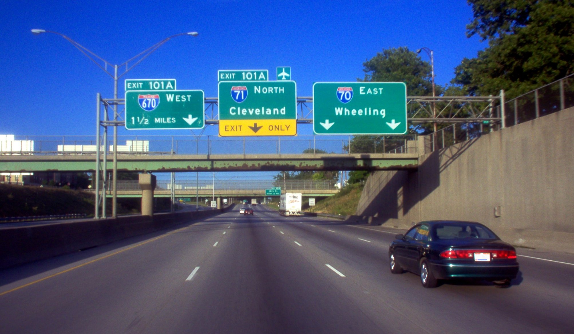
 Intersection of I-70 and I-71 in Columbus, Ohio.
In 1960, State Route 1 followed Central Ave. in Cincinnati, to John Street, to Lincoln Park Drive (now Ezzard Charles Drive), to Freeman Avenue, to Western Avenue, to Spring Grove Avenue, to Colerain Avenue to Interstate 75 (at what is now the I-75/I-74 interchange); Interstate 75 from current I-74 interchange to West Carrollton; U.S. Highway 25 (Dixie Drive) from West Carrollton to Interstate 70; Interstate 70 from Dixie Drive to near Enon (current I-70/OH-4 split); State Route 4 from near Enon to Springfield; U.S. Highway 40 from Springfield to Columbus; Broad St. (US 40) in Columbus, to 4th Street, to Summit/3rd Street (US 23), to Hudson Street, to Interstate 71; I-71 from Columbus to just east of Medina (the only portion of Interstate 71 complete at the time); State Route 18 from near Medina to Montrose; U.S. Highway 21 from Montrose to Brecksville; State Route 82 from Brecksville to Aurora; (an alternate State Route 1 ran from Twinsburg southeast along State Route 14 to Streetsboro and then on State Route 43 to Aurora, in order to connect Highway 1 to the Ohio Turnpike;) State Route 306 from Aurora to State Route 84; State Route 84 from State Route 306 to just west of what was then State Route 44; due south to Interstate 90 along what is now a section of State Route 44; and finally Interstate 90 to the Pennsylvania state line.
In Columbus, the portion of Interstate 71 that bounds Worthington's eastern edge was originally called the North Freeway. Costing US$13.8 million, it was constructed south from Route 161, arriving at 11th Avenue by August 1961. It took another year to construct the portion between 11th Avenue and 5th Avenue, mainly due to the need to construct a massive underpass under the Pennsylvania Railroad's Grogan Yard. Today, only two tracks cross the viaduct, and the rest of the structure supports a large, weedy field. By August 1962, the freeway had reached Fifth Avenue, and it reached downtown in November 1962.
The Highway 1 signage was removed in 1966 as the Interstate Highway numbers adequately marked the route and the state highway numbering was superfluous. The present day route of what was once planned as State Route 1 is Interstate 71 from Cincinnati to just northeast of Medina, Interstate 271 for its entire length from northeast of Medina to Willoughby Hills, and Interstate 90 from Willoughby Hills to the Pennsylvania state line at Conneaut.
Upon its completion, I-71 replaced State Route 3 as the primary highway link between Cincinnati, Columbus, and Cleveland.
Recently, the interchange at milepost 121 north of Columbus was reconstructed to allow access to the eastern extension of Gemini Place. Before that, it was a simple diamond interchange with Polaris Parkway (Ohio State Route 750).
Exit list
State County Location Mile[1][2] # Destinations Notes Kentucky Jefferson Louisville 0.000 I-65 – Nashville, IndianapolisSouthbound exit and northbound entrance 0.000 1 I-64 west – St. LouisSouthbound exit and northbound entrance 0.000 I-64 east – LexingtonNorthbound exit and southbound entrance 1.724 2 Zorn Avenue Indian Hills 4.966 5  I-264 (Watterson Expressway)
Louisville 9.063 9 

 I-265 south (Gene Snyder Freeway) / KY 841 to US 42
Signed as exits 9A (south) and 9B (north) Oldham 14.488 14  KY 329 – Crestwood, Pewee Valley
17.478 17  KY 146 – Buckner, Crestwood, Pewee Valley
18.507 18  KY 393 – Buckner
La Grange 21.869 22  KY 53 – La Grange, Ballardsville
Henry 27.840 28  KY 153 to KY 146 – Sligo, New Castle
Campbellsburg 33.505 34  US 421 – Campbellsburg, New Castle, Bedford
Carroll 42.802 43 
 KY 389 to KY 55 – Prestonville, English
44.312 44  KY 227 – Worthville, Carrollton
Gallatin 54.980 55 
 KY 1039 to KY 465 – Vevay
Serves Kentucky Speedway 56.673 57  KY 35 – Sparta, Warsaw
Serves Kentucky Speedway Glencoe 61.774 62  US 127 – Glencoe, Owenton
Boone 72.195 72  KY 14 – Verona
77.724 77 I-75 south – LexingtonSouth end of I-75 overlap 79.556 175  KY 338 – Richwood
Florence 82.275 178  KY 536 (Mt. Zion Road)
84.298 180 US 42 / US 127 – Union, Florence84.694 180A Mall Road (KY 3157) Southbound exit and northbound entrance; serves Florence Mall 85.449 181  KY 18 – Florence, Burlington
86.652 182  KY 1017 (Turfway Road)
Kenton Erlanger 87.967 184  KY 236 – Erlanger
Signed as exits 184A (east) and 184B (west) southbound 88.900 185 
 I-275 to I-471 – Cincinnati/Northern Kentucky International Airport
Fort Mitchell 90.539 186  KY 371 (Buttermilk Pike)
91.913 188  US 25 / US 42 / US 127 (Dixie Highway) – Fort Mitchell
Fort Wright 92.870 189  KY 1072 (Kyles Lane) – Fort Wright, Park Hills
Covington 94.707-
94.858191 12th Street (KY 1120), Pike Street (US 25 / US 42 / US 127) – Covington 95.414-
95.507192 5th Street (KY 8) – Covington, Newport Brent Spence Bridge over the Ohio River (state line) Ohio Hamilton Cincinnati 0.22-
0.501A  I-75 north / US 50 west (River Road) / Fifth Street – Dayton
North end of I-75 overlap; south end of US 50 overlap 1 Second Street, Third Street – Downtown Cincinnati, Riverfront 1.11  US 50 east (Columbia Parkway) to I-471 / US 52
North end of US 50 overlap; northbound exit and southbound entrance Lytle Tunnel - Sharp turn 40 MPH (70 km/h) in both directions
1.99 1J I-471 south – NewportSouthbound exit and northbound entrance 2.33-
2.482 US 42 (Reading Road) / Florence Avenue, Gilbert Avenue3.33 3 William Howard Taft Road Southbound exit and northbound entrance 4.46-
6.035 Montgomery Road (US 22 / SR 3), Dana Avenue Norwood 6.75-
6.966  SR 561 (Edwards Road, Smith Road)
Cincinnati 8.04 8A Ridge Avenue south Northbound exit and southbound entrance 8.04 8B  SR 562 – Norwood
Signed as exit 7 southbound 8.51 8C Ridge Avenue north Northbound exit and southbound entrance 8.75 8 Kennedy Avenue, Ridge Avenue Southbound exit and northbound entrance 9.91-
9.929 Red Bank Road – Fairfax Silverton 10.68 10 Stewart Road Northbound exit and southbound entrance 11.81 11 Kenwood Road Northbound exit and southbound entrance 12.44 12 
 US 22 / SR 3 (Montgomery Road)
Montgomery 14.13 14  SR 126 (Ronald Reagan Cross County Highway)
15.80 15 Pfeiffer Road 17.51-
17.5417  I-275 to SR 32 / I-75
Signed as exits 17A (east) and 17B (west) southbound 19.88-
19.9719 Mason Montgomery Road, Fields Ertel Road Warren Mason 23.53 24 Western Row Road, Kings Island Drive Northbound exit and southbound entrance 25.30 25  SR 741 north (Kings Mills Road) – Mason
28.33 28  SR 48 – South Lebanon, Lebanon
32.56 32  SR 123 – Morrow, Lebanon
36.74 36 Wilmington Road Clinton 45.11 45  SR 73 – Waynesville, Wilmington
50.74-
50.7550  US 68 – Xenia, Wilmington
Greene 58.01 58 SR 72 – Sabina, JamestownFayette Octa 65.33 65  US 35 (SR 435) – Xenia, Washington Court House
Jeffersonville 69.49 69 
 SR 41 / SR 734 – South Solon, Jeffersonville, Washington Court House
75.03 75  SR 38 – Bloomingburg, Midway
Madison 84.27 84  SR 56 – Mount Sterling, London
Franklin 94.15 94  US 62 / SR 3 – Grove City, Orient, Harrisburg
97.16 97  SR 665 (London-Groveport Road)
Grove City 100.60 100 Stringtown Road – Grove City 101.68 101  I-270 – Dayton, Wheeling
Signed as exits 101A (east) and 101B (west) northbound Columbus 103.86 104  SR 104 / Frank Road
105.43 105 Greenlawn Avenue 106 106A I-70 west – DaytonSouth end of I-70 overlap 106 99B  SR 315 north
107.07-
107.17100A  US 23 south (High Street) / Front Street
No northbound entrance; southbound exit is via exit 100B 107.41 100B US 23 north (Fourth Street) / Livingston Avenue (US 33)107.90-
108.10107 I-70 east – WheelingNorth end of I-70 overlap 108.20 108A Main Street No northbound exit 108.63 108B  US 40 (Broad Street)
108.93 109C Spring Street Southbound exit and northbound entrance 109.38 109B SR 3 (Cleveland Avenue) / Leonard AvenueNo entrance ramps 109.16-
109.61109A  I-670 – Port Columbus International Airport, Dayton
Signed as exits 109A (west) and 109B (east, combined with Leonard Avenue exit) northbound 110.16 110A Fifth Avenue No northbound exit 110.68 110B 11th Avenue 111.15 111 17th Avenue 112.33 112 Hudson Street 112.98 113 Weber Road 113.46 114 North Broadway 114.53 115 Cooke Road 115.58 116 Morse Road, Sinclair Road 117.53 117  SR 161 (Dublin-Granville Road)
119.21-
119.23119 I-270 – Dayton, WheelingSigned as exits 119A (east) and 119B (west) southbound Delaware 121.45-
121.92121  SR 750 (Polaris Parkway) / Gemini Place
130.64 131 
 US 36 / SR 37 – Delaware, Sunbury
Morrow 140.15 140  SR 61 – Cardington, Sunbury, Mount Gilead
151.09 151  SR 95 – Fredericktown, Mount Gilead
Richland Bellville 165.25 165  SR 97 – Lexington, Bellville
Mansfield 168.81 169  SR 13 – Mansfield, Bellville
172.97 173  SR 39 – Mansfield, Lucas
176.91 176  US 30 – Mansfield, Wooster
Ashland 186.71 186  US 250 – Ashland, Wooster
Wayne 196.31 196  SR 301 – West Salem
Northbound exit and southbound entrance 197.92 198  SR 539 – West Salem, Congress
Medina Lodi 203.89 204  SR 83 – Lodi, Wooster
Seville 209.51 209  I-76 / US 224 – Lodi, Akron
Medina Twp. 218.86 218  SR 18 – Akron, Medina
Medina Twp. 220.71 220  I-271 north – Erie
Northbound exit and southbound entrance Medina Twp. 222.91 222 SR 3 – Hinckley, MedinaBrunswick 226.03 226  SR 303 – Brunswick, Hinckley
Cuyahoga Strongsville 231.26 231  SR 82 (Royalton Road) – Strongsville, North Royalton
Signed as exits 231A (east) and 231B (west) southbound 233.06 233 I-80 / Ohio Tpk. – Toledo, YoungstownMiddleburg Heights 234.21 234 US 42 – Strongsville, Parma Heights235.37 235 Bagley Road – Berea, Middleburg Heights Brook Park 237.53 237 Snow Road, Engle Road – Cleveland Hopkins International Airport Signed as exits 237A (east) and 237B (west) southbound 238.77 238  I-480 – Cleveland Hopkins International Airport, Toledo, Youngstown
Northbound exit and southbound entrance Cleveland 239.26 238  I-480 west / SR 237 south – Cleveland Hopkins International Airport, Berea, Toledo
Southbound exit and northbound entrance 240.57 240 West 150th Street 241.85 242A West 130th Street Signed as exit 242 southbound 242.41 242B Bellaire Road Northbound exit and southbound entrance Linndale Cleveland 244.5 244 Denison Avenue, West 65th Street Northbound exit and southbound entrance 245.48-
246.20245 US 42 / SR 3 / (Pearl Road, West 25th Street) / Fulton Road246.6 246  SR 176 south – Parma
Southbound exit and northbound entrance 246.98 247A West 14th Street, Clark Avenue Northbound exit and southbound entrance 247.56 247B  I-490 east to I-77
Northbound exit and southbound entrance 247.56 247B I-90 west – ToledoNorthbound exit and southbound entrance 247.81 I-90 east – Downtown ClevelandNorthbound exit and southbound entrance Auxiliary routes
- I-471 - links downtown Cincinnati with Interstate 275
- I-271 - provides access to Cleveland's eastern suburbs and enables travelers on Interstate 71 to access Interstate 90 east without going through Cleveland proper.
Auxiliary routes of Interstate 71 
See also
- Carrollton bus disaster, a drunk-driving tragedy involving a school bus that occurred on I-71
- Sports rivalries involving cities on I-71
- The I-71 Rivalry: Cincinnati Bengals–Cleveland Browns (NFL)
- The Keg of Nails: Cincinnati Bearcats–Louisville Cardinals (NCAA Football)
References
- ^ a b Kentucky Transportation Cabinet, HIS Expanded Milepoint Route Log Extract, updated October 31, 2007
- ^ a b Ohio Department of Transportation Office of Technical Services: Straight Line Diagrams, current as of January 1, 2007
- ^ "Route Log and Finder List: Table 1 - Interstate System". FHWA. http://www.fhwa.dot.gov/reports/routefinder/table1.cfm. Retrieved 2007-07-09.
External links
- I-71 on Cincinnati-Transit.net
- Interstate-guide.com: Interstate 71
- Historic photo; 1963 aerial view of I-71 construction between 17th and 5th avenues in Columbus, Ohio
- Historic photo; gasoline tanker crash and fire collapses Cleveland Avenue overpass in Columbus, Ohio 6/28/1966
- Historic photo; rebuilding the Cleveland Avenue overpass after it is was destroyed by a gasoline tanker fire in 1966
Main Interstate Highways (major interstates highlighted)
4 5 8 10 12 15 16 17 19 20 22 24 25 26 27 29 30 35 37 39 40 43 44 45 49 55 57 59 64 65 66 68 69 70 71 72 73 74 75 76 (W) 76 (E) 77 78 79 80 81 82 83 84 (W) 84 (E) 85 86 (W) 86 (E) 87 88 (W) 88 (E) 89 90 91 93 94 95 96 97 99 H-1 H-2 H-3 Unsigned A-1 A-2 A-3 A-4 PRI-1 PRI-2 PRI-3 Lists Primary Main - Intrastate - Suffixed - Temporary - Future - Gaps Auxiliary Main - Future - Unsigned Other Standards - Business - Bypassed - Tolled Categories:- Interstate Highway System
- Interstate Highways in Kentucky
- Interstate Highways in Ohio
- Interstate 75
- Transportation in Louisville, Kentucky
- Transportation in Cincinnati, Ohio

Wikimedia Foundation. 2010.