- Interstate 84 (west)
Infobox road
route=84
route_type=reg
type=I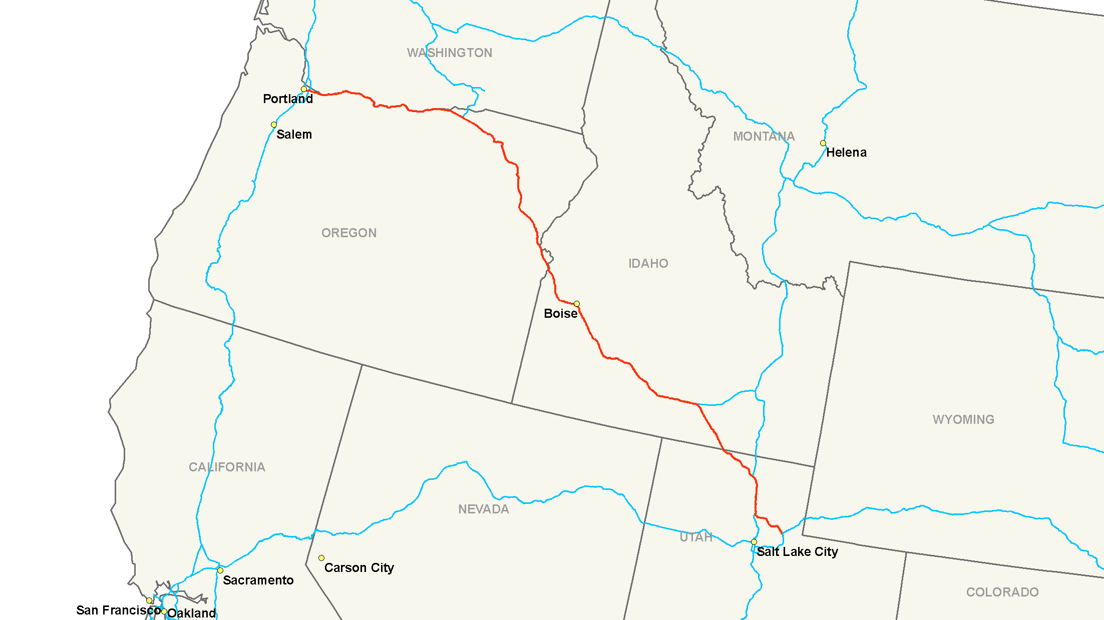
length_mi=770
year_established=1966
direction_a=West
direction_b=East
length_km=1239
terminus_a=
terminus_b=
junction=
commons=categoryInterstate 84 (I-84) is an
interstate highway in theWestern United States that runs fromPortland, Oregon (intersecting I-5) toEcho, Utah (intersecting I-80 [cite web |url=http://maps.google.com/maps?ll=40.976529,-111.444626&spn=0.114256,0.236464&hl=en |title=Google map of Echo, Utah|accessdate=2007-12-14|publisher=Google ] ) and via I-86Pocatello, Idaho (intersecting with I-15). It follows roughly the same route as theOregon Trail . (There is also a separate I-84 in theNortheastern United States .)Starting in Portland, where it is referred to as the
Banfield Expressway , the interstate runs through theColumbia River Gorge parallel to theHistoric Columbia River Highway to The Dalles. It then continues along theColumbia River until it veers in a southeasterly direction at Boardman. East ofPendleton it heads through the Blue Mountains region of eastern Oregon and then crosses theSnake river intoIdaho .Crossing central Idaho, I-84 passes through Boise (a spur,
I-184 connects to the city center), near Twin Falls and through Burley and Rupert. East of Rupert it veers to the southeast and crosses theUtah border. The highway runs concurrently with I-15 between Tremonton and Ogden, running through Brigham City. I-84 terminates at an intersection with I-80 in Summit County near Echo.The western section of I-84 was known as I-80N until
May 1 ,1980 cite web| url = http://www.dot.utah.gov/main/uconowner.gf?n=200609181109591|title = Highway Resolutions - Route 84|publisher = Utah Department of Transportation|accessdate = 2008-05-18] . There was also an I-80S, which is now numbered I-76. Changes in federal guidelines discouraged the use of suffix letters on interstate highways. As a result these two were renumbered. [The only remaining such split is I-35E and I-35W, which exists in the Dallas/Fort Worth area and the Minneapolis/St. Paul area.]Route description
-
OR
375
603
-
ID
276
444
-
UT
119
192
-
Total
770
1239Oregon
In the
Portland metropolitan area , I-84 is sometimes referred to as the Banfield Freeway or simply "the Banfield", although the official name is the Banfield Expressway. The freeway is named afterThomas H. Banfield , chairman of the Oregon Transportation Commission from 1943-1950.East of
Pendleton, Oregon , I-84 traverses the infamous Cabbage Hill grade (a 6% grade). This grade is legendary for the fact that the westbound lanesswitchback twice on its descent into Pendleton. Eastbound lanes feature what are the tightest curves on the Interstate system, even though those curves are on the uphill (eastbound) direction. This grade is also well known due to the fact that it features such a great distance between eastbound and westbound lanes, nearly convert|2|mi|km between directions of travel at points.Idaho
I-84 enters Idaho at a crossing of the
Snake River just east ofOntario, Oregon . From there, it continues on to the major cities of theBoise metropolitan area , including Caldwell, Nampa, Meridian, and Boise (whereI-184 connects travelers to downtown). FromBoise , I-84 continues on towardsTwin Falls after passing near several small towns (such as Mountain Home, Glenns Ferry, and Jerome).Just east of Jerome I-84 passes within 5 miles (8 kilometers) of Twin Falls, but does not cross the Snake River Canyon or into Twin Falls County. Access to Twin Falls is afforded by an intersection with US 93.
After Twin Falls, I-84 continues through Burley and Heyburn. Approximately 7 miles (11.3 kilometers) east of Declo in rural Cassia County, I-84 splits into two branches. One continues as I-84, heading southeast towards Utah. The other is straighter and is known as I-86, heading to American Falls and Pocatello.
Utah
From Idaho, I-84 enters Utah at a point approximately 7 miles (11.3 kilometers) from Snowville in Box Elder County. It proceeds southeast towards Tremonton where I-84 joins the route of I-15.
Just south, at
Corinne, Utah , I-84 joins the route of theFirst Transcontinental Railroad which the highway follows to the its terminus. I-15/I-84 pass to the west of Ogden where I-84 separates from I-15 and follows theWeber River . As the freeway passes through Weber Canyon it also passes through several small farming communities, including Morgan, where theBrowning Arms Company headquarters can be seen from the freeway. Also visible in the canyon is Devil's Slide, an unusual rock formation just off the freeway. [cite web
url = http://content.cdlib.org/ark:/13030/tf8b69p56f/
title = The Devil's Slide, Weber Canyon, Utah
author = Unknown
accessdate = 2007-01-06
publisher = California Digital Library, Board of Regents, University of California. Featuring content donated by Bancroft Library] Farther up the canyon is the convert|1000|mi|km|sing=on tree, planted byUnion Pacific Railroad workers to mark convert|1000|mi|km from the railroad's origin inOmaha, Nebraska . [cite web
url = http://library.usu.edu/Specol/photoarchive/p0019/p00190019.html
title = Sun Pictures of Rocky Mountain Scenery, Photographic Collection
author = F.V. Hayden and Daniel M. Davis
accessdate = 2007-01-06
publisher =Utah State University Special Collections and Archives] The freeway ends at Echo, a near ghost town that before served as a stopover for the railroad, at a junction withInterstate 80 . Also near the junction is Echo Reservoir and Echo Dam.The Utah sections of I-84 not concurrent with Interstate 15 are defined at Utah Code Annotated § 72-4-114(4). [ [http://le.utah.gov/~code/TITLE72/htm/72_04016.htm Utah Code Annotated for overlap with I-15] ]
History
American Association of State Highway and Transportation Officials established guidelines recommending that "suffixed" highways, such as I-80N, be renumbered. In 1977, Idaho officials recommended that I-80N be renumbered to I-84. The motion was seconded by officials in Utah, but opposed by Oregon and Washington. The motion passed onJuly 7 ,1977 , and the states were given untilJuly 1 ,1980 to implement a co-ordinated renumbering strategy.After renumbering, I-84 violated the Interstate Highway Numbering Convention by being south of I-82. The Portland segment of then-I-80N was proposed to run on the
Mount Hood Freeway . Plans for this were officially dropped in 1978 after a successful freeway revolt.Major intersections
*
*
*
*
*
*.
*Auxiliary routes
*
Boise, Idaho - I-184ee also
*
Interstate 86 (west)
*Interstate 84 (east) References
Wikimedia Foundation. 2010.