- Interstate 15
Infobox road
type=I
route=15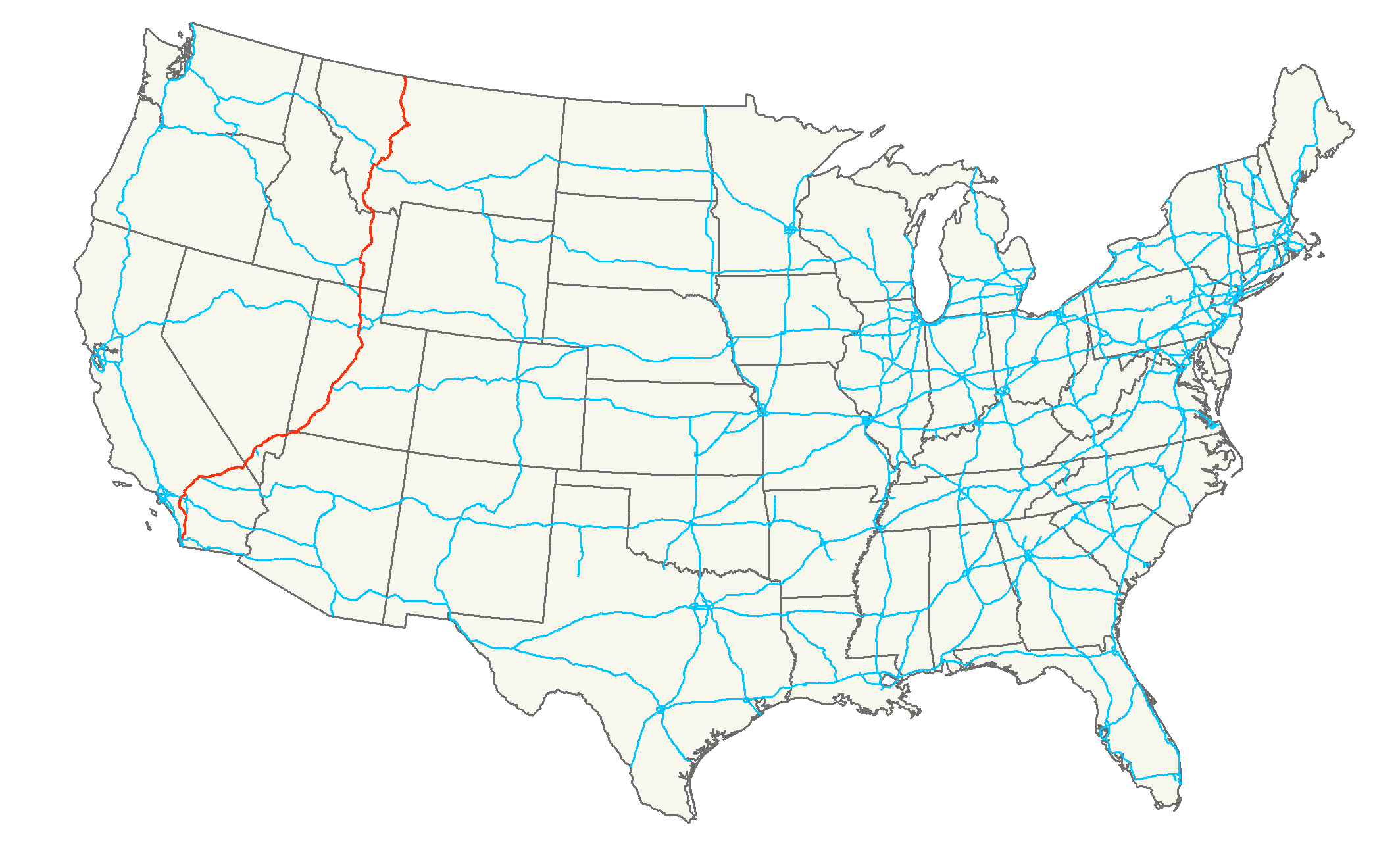
length_mi=1433.52
length_round=2
length_ref=cite web|publisher=Interstate Guide|url=http://www.interstate-guide.com/i-015.html|title=Interstate 15 @ Interstate-Guide.com|accessdate=2008-02-15]
established=1957
direction_a=South
terminus_a=
junction=
direction_b=North
terminus_b=Jct|state=AB|Hwy|4 at Canadian border near Sweetgrass, MT
commons=categoryInterstate 15 (I-15) is the fourth-longest north-south transcontinental interstate highway in the
United States , traveling through the states ofCalifornia ,Nevada ,Arizona ,Utah ,Idaho , andMontana . The Utah and Arizona portions have been officially designated the 'Veterans Memorial Highway'.cite web
url = http://www.rockymountainroads.com/i-015a_ut.html
title = Utah@Rocky Mountain Roads - Interstate 15
accessdate = 01-02-2008
publisher = Aaroads]Since I-15's inception, it has served as a long-haul route for
North America n commerce. It is now officially chartered for this purpose. From the junction ofInterstate 515 in Las Vegas to the Canadian border I-15 forms part of theCANAMEX Corridor , aHigh Priority Corridor , as a result of theNorth American Free Trade Agreement .cite web
url = http://www.canamex.org/
title = CANAMEX CORRIDOR, The safe, smart and secure corridor
accessdate =01.02.2008
publisher = Canamex Corridor Project]Local portions were built to connect the Inland Empire with San Diego in California, facilitate tourism access to Las Vegas, interconnect all of the
Metropolitan Statistical Area s in Utah except Logan, and provide freeway bypasses for Pocatello, Idaho Falls and Great Falls.Since I-15's initial construction, California, Nevada, and Utah have consistently ranked in the fastest growing areas of the United States. As a result, the I-15 corridor has substantially increased in population and commuter traffic has increased the traffic burden on the freeway. Current population estimates are that more than 75 percent of Utah's populationcite web
url = http://www.utah.com/visitor/state_facts/population.htm
title = Population-Visitor Center- Utah.com
accessdate = 01-02-2008
publisher = Utah Travel Industry] , 19 percent of California's population, and more than 70 percent of Nevada's populationcite web
url = http://www.nsbdc.org/what/data_statistics/demographer/pubs/pop_increase/
title = 2006 Estimates by County
accessdate = 01-02-2008
publisher = Nevada Small Business Development Center] live in counties where Interstate 15 is the primary transportation corridor. Similarly, in California, I-15 is seeing more commuter traffic due to the growth of theMojave Desert communities of Victorville andBarstow, California . In all of these states, I-15 has recently been or is currently in the process of being upgraded to increase capacity.cite web
url = http://www.dot.utah.gov/main/f?p=100:pg:8021324352851618309:::1:T,V:69,
title = Utah Department of Transportation, Projects Under Construction
accessdate = 01-02-2008
publisher = Utah Department of Transportation] [cite web
url = http://www.nevadadot.com/traveler/construction_projects/construction/district.asp?district=1
title = District 1 Construction Report
accessdate = 01-02-2008
publisher = Nevada Department of Transportation] [cite web
url = http://www.dot.ca.gov/dist8/projects/15/I-15%20Brstw%20-STLN.revsd%206-2004%20copy.pdf
title = Interstate 15 Major Improvements
publisher = California Department of Transportation] The Arizona, Idaho and Montana portions have retained their rural, long-haul character. Although Arizona has also grown substantially since I-15's inception, I-15 only serves an isolated corner of the state.Due to this rapid area growth, the I-15 corridor is the focus of several
mass transit projects. TheLas Vegas Monorail ,FrontRunner commuter rail system and TRAXlight rail in Salt Lake City are mass transit lines loosely parallel to I-15 that are now in operation. Between Los Angeles and Las Vegas has long been proposed as a maglev train route; in 2004 theCalifornia-Nevada Interstate Maglev project held public meetings on the plan. [cite web
author = Staff.
url = http://www.progressiverailroading.com/transitnews/article.asp?id=4809
title = FRA to begin environmental study for California-to-Nevada Maglev project
accessdate = 04.21.2007.]Route description
-
CA
287
462
-
NV
124
200
-
AZ
29
47
-
UT
401
645
-
ID
196
315
-
MT
396
637
-
Total
1,433
2,307This highway's southern terminus is in
San Diego, California atInterstate 8 , 18 miles (29 km) north of the international border with Mexico. However, work is being done to extend this toInterstate 5 . The current work on this extension is signed State Route 15. There is a continuous freeway between I-8 and I-5, but various intersections and acceleration/deceleration lanes are not up to interstate standards. The northern terminus is inSweetgrass, Montana at the international border between theUnited States andCanada , where it becomesAlberta Highway 4 .California
North of its junction with the Riverside Freeway, State Route 91, in the Inland Empire near Corona, the route roughly follows the former routes of
U.S. Highway 91 andU.S. Highway 395 . North of Devore, the highway follows the approximate alignment of historicU.S. Highway 66 along with U.S. 91 and 395. U.S. 395 breaks away at Hesperia and the route continues the approximate route of co-signed 66 and 91 until about the Mojave River, 35 miles (56 km) to the north. At that point, I-15 follows the old route of U.S. 91 exclusively. For many parts of the highway, high-voltage power lines, likePath 46 andPath 27 , almost all from theHoover Dam , follow the freeway. Many of these link distant power stations to theLos Angeles metropolitan area.The starting point of Interstate 15 was originally planned to be in San Bernardino at an interchange with the San Bernardino Freeway, I-10. This was logical as I-15 was following the old alignment of the historic Route 66 which passed through San Bernardino. The segment was completed accordingly. However, legislation was later passed to extend the interstate to San Diego. But instead of extending the existing freeway from the I-10 interchange south, the
California Department of Transportation made a new segment in Devore that 'branched' off of the original alignment and bypassed San Bernardino altogether. This segment's alignment is generally northeast to southwest for about 15 miles (24 km). Then, in Fontana/Rancho Cucamonga, its directional alignment shifts to north-south where it eventually junctions with Interstate 10 (about 15 miles or 24 kilometers west of the original interchange in San Bernardino). The segment that had been built from Devore to San Bernardino was retained as an interstate, but was re-numbered as Interstate 215. Note that during the construction of I-15's present alignment, and for some time afterwards, I-215 was numbered as I-15E, and its actual mileage would begin at Interstate 10.Nevada
Interstate 15 begins in Primm, continues through Las Vegas along the
Las Vegas Strip corridor. Then the interstate crosses the border withArizona in Mesquite. The whole interstate inNevada runs entirely in Clark County, for a distance of convert|123.77|mi|km.Arizona
I-15 just clips the northwestern corner of
Arizona with a total length of 29.4 miles (47 km). [Arizona Department of Transportation Project 015 MO 000 H577901C, sheet 73 of 103 - revised May 2005] The stretch is separated from the rest of the state and has one major exit, at Beaver Dam/Littlefield, Arizona . It includes a spectacular section where the road twists between the narrow walls of theVirgin River Gorge .Utah
I-15 continues through
Utah for just over 400 miles (640 km). It is the main north-south connection for the state. The highway approximately follows the old alignment ofU.S. Highway 91 from St. George to Brigham City. The highway passes through the fast-growing Dixie region, which includes St. George, Cedar City, and eventually most of the major cities and suburbs along theWasatch Front , including Provo, Orem, Sandy, West Jordan, Salt Lake City, Layton, and Ogden. Near Cove Fort,Interstate 70 begins its journey eastward across the country. The interstate merges with I-80 for about 3 miles (5 km) from South Salt Lake to just west ofDowntown Salt Lake City and also merges with Interstate 84 from Ogden to Tremonton. Along nearly its entire length through the state, I-15 winds its way along the western edge of a nearly continuous range of mountains (theWasatch Range in the northern half of the state). The only exceptions are when it passes through the mountains south of Cedar City and again north of Cove Fort.Idaho
I-15 passes through
Idaho for nearly 200 miles (320 km). The highway runs through Pocatello, Blackfoot, and Idaho Falls.Montana
Interstate 15 continues onward through nearly 400 miles (640 km) of
Montana through the cities of Butte, Helena and Great Falls, intersecting withInterstate 90 ,Interstate 115 andInterstate 315 . At Sweetgrass, I-15 terminates upon crossing the international border intoAlberta ,Canada ; however, I-15 signage is present onAlberta Highway 4 southbound fromLethbridge to the U.S.-Canada Border.History
Interstate 15 was constructed along the route of
U.S. Route 91 . Once Interstate 15 was relatively intact U.S. 91 was decommissioned, except for one part in Northern Utah/Southern Idaho where Interstate 15 instead followed the route of formerU.S. Route 191 .Interstate 15 had an eastern branch bypassing
San Bernardino, California , and a western branch inIdaho . I-215 around San Bernardino was I-15E [http://www.interstate-guide.com/i-215_ca.html Interstate-Guide.com entry for Interstate 215 California] , and the western I-86 was once called I-15W. [http://www.interstate-guide.com/i-086_west.html Interstate-Guide.com entry for I-86 Western]Future
Redesignation of SR 15 in San Diego as I-15 will eventually occur when the freeway's interchange with SR 94 is updated to
Interstate standards . The interchange currently has left-exits and blind merges, and is due to be updated with a long-awaited widening of SR 94 in2008 . At that time SR 15 will be resigned as part of I-15.Major intersections
Listed in order from south to north:
California
*Interstate 8 in San Diego
*Interstate 215 in Murrieta
*Interstate 10 in Ontario
*Interstate 215 in Devore
*Interstate 40 in BarstowNevada
*
Las Vegas Beltway ("I-215" to the east, "CC 215" to the west) in unincorporated Clark County (Paradise) nearMcCarran International Airport
*U.S. Route 95 (also U.S. Route 93 and Interstate 515 to the east) in Las VegasArizona
Interstate 15 does not intersect any interstate highway in Arizona.
Utah
*Interstate 70 in Cove Fort
*Interstate 215 in Murray
*Interstate 80 in South Salt Lake; they merge for about 3 mi (5 km) into Salt Lake City
*Interstate 215 in North Salt Lake
*Interstate 84 in Ogden; they stay merged until TremontonIdaho
*Interstate 86 in Pocatello
Montana
*Interstate 90 in Butte; they are merged for 9 miles (14.5 km)
*Interstate 115 in Butte.Auxiliary routes
*Inland Empire, California - I-215
*Spur toHenderson, Nevada outside Las Vegas - I-515
*BeltwayLas Vegas, Nevada - I-215
*Salt Lake City, Utah - I-215
*Butte, Montana - I-115
*Great Falls, Montana - I-315ee also
*State Route 15
*U.S. Route 66
*U.S. Route 91 References
External links
*http://www.dot.ca.gov/dist11/facts/I-15managed.pdf
*2005 Rand McNally "The Road Atlas 2005" - newest feature- interstate mileage by stateCalifornia
* [http://www.cahighways.org/009-016.html#015 California Highways: SR 15]
* [http://www.dot.ca.gov/hq/traffops/signtech/calnexus/reports/fifteennorth.htm Cal-NExUS: Route 15 North]
* [http://www.dot.ca.gov/hq/traffops/signtech/calnexus/reports/fifteensouth.htm Cal-NExUS: Route 15 South]Arizona
* [http://www.interstate50th.org/history/2006-12-14.shtml I-15 Completed December 14, 1973]
Wikimedia Foundation. 2010.