- Corona, California
-
Corona — City — A view of Corona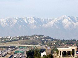

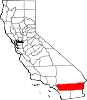
SealNickname(s): The Circle City, Crown Town Location of Corona, California
Coordinates: 33°52′N 117°34′W / 33.867°N 117.567°WCoordinates: 33°52′N 117°34′W / 33.867°N 117.567°W Country  United States
State  California
County Riverside Government - Type Council-Manager - Mayor Stan Skipworth Area[1] - Total 38.930 sq mi (100.829 km2) - Land 38.825 sq mi (100.558 km2) - Water 0.105 sq mi (0.272 km2) 0.27% Elevation 678 ft (206 m) Population (2010) - Total 152,374 - Rank 3rd in Riverside County
33rd in California
159th in the United States- Density 3,914.1/sq mi (1,511.2/km2) Time zone PST (UTC-8) - Summer (DST) PDT (UTC-7) ZIP codes 92877-92883 Area code(s) 951 FIPS code 06-16350 GNIS feature ID 1652691 Website City of Corona Corona is a city in Riverside County, California, United States. As of the 2010 census, the city had a population of 152,374, up from 124,966 at the 2000 census. The city of Norco and Riverside lie to the northeast, Chino Hills to the northwest, Yorba Linda, and the Cleveland National Forest to the southwest; unincorporated areas of Riverside County line all of its other borders.
Contents
History
Corona, founded at the height of the Southern California citrus boom in 1886, is advantageously situated at the upper end of the Santa Ana River Canyon, the only significant pass through the Santa Ana Mountains. The town of Corona once laid claim to the title "Lemon Capital of the World." A museum there presents the lemon's former role in the local economy. The city derived its name (and its nickname, The Circle City) from the curious layout of its streets, with a standard grid enclosed by the circular Grand Boulevard, one mile in diameter. The street layout was designed by Hiram Clay Kellogg, a civil engineer from Anaheim who was an influential figure in the early development of Orange County.[citation needed]
The origin of the city was in May, 1886, when the South Riverside Land and Water Company was incorporated, its members including ex-Governor of Iowa, Samuel Merrill, R.B. Taylor, George L. Joy, A.S. Garretson, and Adolph Rimpau, as a citrus growers’ organization, it purchased the lands of Rancho La Sierra of Bernardo Yorba, and the Rancho Temescal grant and the colony of South Riverside was laid out. They also secured the water rights to Temescal Creek, its tributaries and Lee Lake. Dams and pipelines were built to carry the water to the colony. In 1889 the Temescal Water Company was incorporated, to supply water for the new colony. This company purchased all the water-bearing lands in the Temescal valley and began drilling artesian wells.[2]
In 1896, South Riverside was renamed Corona for Grand Boulevard, a 3 mile circular drive that is around the central city and was the site of three international automobile races in 1913, 1914 and 1916.[3] The city of Corona has been popular among celebrities drawn to its upscale areas. Desi Arnaz and Lucille Ball spent time at their ranch, located in south Corona, and played golf often at Cresta Verde Golf Course in the northeastern section of the city.[4] After their divorce, Mr. Arnaz continued to live in Corona.
In recent years Corona has been known as the Gateway to the Inland Empire. Prior to the 1980s, the city was a largely agricultural community, dominated by citrus orchards, ranches, and dairy farms. High real estate prices in Los Angeles and Orange counties made the area's land desirable to developers and industrialists, and by the late 1990s Corona was considered a major suburb of Los Angeles.[citation needed]
Corona has become a bedroom community for Orange County and the larger cities of the Inland Empire. The development of commerce and industry in the city has been accelerated by access to the area via the Riverside Freeway, with many firms leaving northern Orange County to be closer to their employees' homes in Corona and Riverside. The construction of the nearby Chino Valley Freeway has linked Corona to the Pomona and San Gabriel valleys.
Corona County proposal
In 2002 the city government considered an initiative to secede from Riverside County and form an autonomous Corona County because the city government and some residents were dissatisfied with how services were handled in nearby areas. The effort was also considered by areas in other cities in the western part of the county including Murrieta. Whether nearby cities such as Norco, California would have been included in the new county are unknown. The proposed county would have been bordered by San Bernardino County to the northwest and by Orange County to the west.[5]
2008 Freeway Complex Fire
The city was the first to be affected by the Freeway Complex Fire, but was in the Yorba Linda/Corona Line.
Geography and climate
Corona is located at 33°52′N 117°34′W / 33.867°N 117.567°W (33.8700, -117.5678).[6]
According to the United States Census Bureau, the city has a total area of 38.9 square miles (101 km2), of which, 38.8 square miles (100 km2) of it is land and 0.1 square miles (0.26 km2) of it (0.27%) is water.
In recent years, there are talks to construct a proposed 10-mile automobile and fast-speed train tunnel under Santiago Peak to connect Interstate 15 in Corona with Interstate 5 and the 55 Freeway of Orange County, to cut down on commuter traffic on the already crowded or high-traffic 91 Freeway.
Corona experiences a warm Mediterranean climate (Köppen climate classification CSa) and has mild winters and hot summers. Most of the rainfall (as in all of Southern California) occurs during winter and early spring. The winter low temperatures can get cold enough for frost, with rare snowfall seen on the local foothills. Winter days are pleasant, with the mercury staying around 65 degrees Fahrenheit (occasionally warming into the 70s). Summertime is hot, with highs averaging in the low 90s. During the hottest months, daytime temperatures in Corona often exceed 100 degrees.[7]
Climate data for Corona Month Jan Feb Mar Apr May Jun Jul Aug Sep Oct Nov Dec Year Record high °F (°C) 93
(34)91
(33)100
(38)100
(38)107
(42)110
(43)110
(43)110
(43)114
(46)108
(42)99
(37)94
(34)114
(46)Average high °F (°C) 68
(20)70
(21)71
(22)77
(25)80
(27)87
(31)92
(33)93
(34)90
(32)83
(28)74
(23)68
(20)79.4 Average low °F (°C) 42
(6)43
(6)45
(7)48
(9)52
(11)56
(13)60
(16)61
(16)59
(15)52
(11)45
(7)40
(4)50.3 Record low °F (°C) 23
(−5)26
(−3)28
(−2)30
(−1)32
(0)42
(6)47
(8)43
(6)41
(5)29
(−2)26
(−3)22
(−6)22
(−6)Precipitation inches (mm) 2.72
(69.1)2.88
(73.2)2.31
(58.7).68
(17.3).16
(4.1).02
(0.5).02
(0.5).12
(3).23
(5.8).36
(9.1)1.03
(26.2)1.47
(37.3)12
(305)Source: [8] Economy
Some businesses headquartered in Corona:
- Fender Musical Instruments Corporation guitar manufacturer. Includes the Fender Custom Shop and the Fender Center for Music Education, commonly known as the Fender Museum.
- Hansen Natural Corporation, a soft drinks manufacturer. Corona also serves as the corporate base for its Monster Energy products.
- Watson Pharmaceuticals, the 5th largest pharmaceutical company in the United States based on number of prescriptions dispensed.
- West Coast Customs, a car remodeling company featured on the MTV show Pimp My Ride, and now on Discovery Channel show Street Customs.
Top employers
According to the City's 2010 Comprehensive Annual Financial Report,[9] the top employers in the city are:
# Employer # of Employees 1 Corona-Norco Unified School District 4,906 2 Corona Regional Medical Center 1,171 3 Watson Pharmaceuticals 1,045 4 City of Corona 894 5 Kaiser Permanente 655 6 Fender 650 7 All American Asphalt 650 8 TWR Framing 400 9 Dart Container 360 10 Core-Mark 308 Demographics
Historical populations Census Pop. %± 1900 1,434 — 1910 3,540 146.9% 1920 4,129 16.6% 1930 7,018 70.0% 1940 8,764 24.9% 1950 10,223 16.6% 1960 13,336 30.5% 1970 27,519 106.4% 1980 37,791 37.3% 1990 76,095 101.4% 2000 124,966 64.2% 2010 152,374 21.9% 2010
The 2010 United States Census[10] reported that Corona had a population of 152,374. The population density was 3,914.0 people per square mile (1,511.2/km²). The racial makeup of Corona was 90,925 (59.7%) White, 8,934 (5.9%) African American, 1,153 (0.8%) Native American, 15,048 (9.9%) Asian, 552 (0.4%) Pacific Islander, 28,003 (18.4%) from other races, and 7,759 (5.1%) from two or more races. Hispanic or Latino of any race were 66,447 persons (43.6%).
The Census reported that 151,863 people (99.7% of the population) lived in households, 229 (0.2%) lived in non-institutionalized group quarters, and 282 (0.2%) were institutionalized.
There were 44,950 households, out of which 22,735 (50.6%) had children under the age of 18 living in them, 27,357 (60.9%) were opposite-sex married couples living together, 5,971 (13.3%) had a female householder with no husband present, 3,004 (6.7%) had a male householder with no wife present. There were 2,690 (6.0%) unmarried opposite-sex partnerships, and 289 (0.6%) same-sex married couples or partnerships. 6,455 households (14.4%) were made up of individuals and 2,224 (4.9%) had someone living alone who was 65 years of age or older. The average household size was 3.38. There were 36,332 families (80.8% of all households); the average family size was 3.72.
The population was spread out with 45,674 people (30.0%) under the age of 18, 15,504 people (10.2%) aged 18 to 24, 44,215 people (29.0%) aged 25 to 44, 35,801 people (23.5%) aged 45 to 64, and 11,180 people (7.3%) who were 65 years of age or older. The median age was 32.5 years. For every 100 females there were 97.0 males. For every 100 females age 18 and over, there were 94.5 males.
There were 47,174 housing units at an average density of 1,211.8 per square mile (467.9/km²), of which 30,210 (67.2%) were owner-occupied, and 14,740 (32.8%) were occupied by renters. The homeowner vacancy rate was 2.3%; the rental vacancy rate was 5.3%. 103,170 people (67.7% of the population) lived in owner-occupied housing units and 48,693 people (32.0%) lived in rental housing units.
2000
As of the census[11] of 2000, there were 124,996 people, 37,839 households, and 30,384 families residing in the city. The population density was 3,555.5 people per square mile (1,372.7/km²). There were 39,271 housing units at an average density of 1,117.3 per square mile (431.4/km²). The racial makeup of the city was 75.0% White, 6.4% Black or African American, 0.9% Native American, 7.5% Asian, 0.3% Pacific Islander, 17.5% from other races, and 5.3% from two or more races. 25.5% of the population were Hispanic or Latino of any race.
There were 37,839 households out of which 49.6% had children under the age of 18 living with them, 63.8% were married couples living together, 11.2% had a female householder with no husband present, and 19.7% were non-families. 14.4% of all households were made up of individuals and 3.8% had someone living alone who was 65 years of age or older. The average household size was 3.3 and the average family size was 3.6.
In the city the population was spread out with 33.4% under the age of 18, 8.9% from 18 to 24, 35.1% from 25 to 44, 16.8% from 45 to 64, and 5.8% who were 65 years of age or older. The median age was 30 years. For every 100 females there were 98.0 males. For every 100 females age 18 and over, there were 95.6 males.
The median income for a household in the city was $98,615, and the median income for a family was $83,505 (these figures had risen to $88,620 and $95,450 respectively as of a 2007 estimate[12]). Males had a median income of $44,752 versus $31,884 for females. The per capita income for the city was $21,001. About 6.0% of families and 8.3% of the population were below the poverty line, including 10.1% of those under age 18 and 7.3% of those age 65 or over.
Neighborhoods
North Corona
The north part of the city of Corona borders the city of Norco. This area (north of the 91 Freeway) is primarily residential and commercial. The makeup is primarily middle and upper-middle income, with most housing being built after the late 1990s, and is known for being well maintained and very safe. Ethnically, this part of the city is primarily white, with a significant Asian American population as well. This area is home to well rated schools as well as shopping including Costco, Home Depot, and others.
Central Corona
The central city area includes the inner circle of Grand Avenue as well as all areas south of the 91 Freeway and north of Ontario Avenue. This is the oldest area of the city by far, with most housing having been built around 1910. This part of the city has a mixed Hispanic and white population.
South Corona
South Corona is the newest and most upscale part of the city, and is located south of Ontario Avenue. Most housing stock was built between the early 2000s to the present, and ranges from suburban neighborhoods to custom built mansions in the foothills. This area has the highest rated schools in the city (as well as some of the highest in the region) and is known for being very clean, safe, and well maintained. It is primarily upper-middle class and upper class income levels. Most of the residents of south Corona are of Caucasian descent, and it is the most expensive part of the city. Many professional athletes and celebrities call this area home. The south Corona area also extends into west Corona.
Politics
In the state legislature Corona is located in the 37th Senate District, represented by Republican Bill Emmerson, and in the 71st Assembly District, represented by Republican Jeff Miller. Federally, Corona is located in California's 44th congressional district, which has a Cook PVI of R +6[13] and is represented by Republican Ken Calvert.
Infrastructure
Transportation
The city is served by Chino Valley (SR 71), Ontario (I-15), and Riverside (SR 91) freeways, as well as the 91 Line of the Metrolink commuter rail system. The city's downtown area is circled by Grand Boulevard, which is very unusual for being perfectly circular. The street is approximately 1 mile in diameter.
Corona Municipal Airport (FAA designator: AJO) serves the city and has a 3,200-foot (980 m) runway. On January 20, 2008, two small passenger aircraft collided over Corona, killing all four men aboard the planes and another man on the ground. In the past ten years, there have been five fatal plane crashes around Corona.
Healthcare
Corona Regional Medical Center is a General Acute Care Hospital with Basic Emergency Services as of 2005.[14]
Education
The city of Corona is a part of the Corona-Norco Unified School District.[15]
There are eight high schools in Corona: Corona, Centennial, Lee V. Pollard (formerly Buena Vista), Orange Grove, Santiago, Norco, John F. Kennedy Middle College High School and Eleanor Roosevelt High School.
There are seven middle schools in Corona: Auburndale, Citrus Hills, Corona Fundamental, El Cerrito, Raney, Norco, and River Heights.
There are also 31 elementary schools in the city: John Adams, Susan B. Anthony, Clara Barton, Cesar Chavez, Corona Ranch, Coronita, Eastvale, Dwight Eisenhower, Foothill, Ben Franklin, Garretson, Harada, Highland, Home Gardens, Jefferson, Lincoln Alternative, William McKinley, Norco, Orange, Parkridge, Prado View, Promenade, Rosa Parks, Riverview, Sierra Vista, Stallings, Temescal Valley, Dr. Bernice Todd, Vandermolen, Vicentia, Victress Bower, George Washington and Woodrow Wilson.
Students interested in Catholic education services can attend St. Edwards Catholic School in Corona.
Utilities
Southern California Edison services most of the electricity and a small part of the city is serviced by Corona Department of Water and Power. Waste Management Inc. provides waste disposal for the city.
Cemetery
The Corona Sunnyslope Cemetery[16][17] is a non-profit cemetery established in 1892.[18]
Religion
Many different religions are practiced in Corona. There are many different mainline and evangelical Protestant congregations in the city. There are also several Roman Catholic churches, including St. Edwards in central Corona, Corpus Christi in east Corona, St. Matthew in west Corona and St. Mary Magdalene in south Corona. Santa Clara de Asis Catholic Church in neighboring Yorba Linda also includes residents of west Corona. The Islamic Society of Corona/Norco has a mosque in the city and the Jewish community has purchased land and is constructing a temple. There is a significant Church of Jesus Christ of Latter-day Saints community in Corona with many churches throughout town.[citation needed] The influx of Asian-Americans has brought in an increase of people in eastern religions: Buddhism, Confucianism, Hinduism, Shintoism, and Taoism.[citation needed]
Notable natives and residents
- Travis Barker - drummer for Blink 182
- Larissa Hodge - (Bootz) reality television participant (Flavor of Love 2), (Flavor of Love Girls: Charm School)
- Tyler Hoechlin - actor, baseball player
- Kerry King - guitarist for Slayer[citation needed]
- Crystal Lewis - Christian music singer, TV actress.[19]
- Billy Marks - professional skateboarder
- Taylor Martinez — quarterback for the Nebraska Cornhuskers
- Taryne Mowatt - Arizona Wildcats All-American softball pitcher & two-time ESPN ESPY Award winner
- Ricky Nolasco - Major League Baseball pitcher for the Florida Marlins
- Lonie Paxton - football player for the Denver Broncos
- Jenni Rivera - vocalist/songwriter of banda music
- D.J. Strawberry - professional basketball player
- Jodie Sweetin - actress known for her role as Stephanie Tanner on the television sitcom Full House[20]
- Gary Webb - investigative journalist whose work disclosed the role of the CIA, via the Nicaragua Contras, in bringing crack cocaine into Los Angeles
Missing time capsules
Corona has been referred to as the 'record holder in the fumbled time capsule category' with 17 time capsules buried - and lost.[21]
See also
- Rancho Temescal (Serrano)
References
- ^ U.S. Census
- ^ Ellerbe, History of Temescal Valley, pp.18-19
- ^ Hoover, Mildred B.; Hero & Ethel Rensch, and William N. Abeloe (1966). Historic Spots in California. Stanford University Press. ISBN 978-0804744829.
- ^ www.crestaverde.com
- ^ Santa Barbara News Press article on the county split proposal there with a brief mention of the proposed Corona County.
- ^ "US Gazetteer files: 2010, 2000, and 1990". United States Census Bureau. 2011-02-12. http://www.census.gov/geo/www/gazetteer/gazette.html. Retrieved 2011-04-23.
- ^ www.weather.com
- ^ "Corona weather averages". Weather. http://www.weather.com/outlook/health/fitness/wxclimatology/monthly/graph/USCA0252. Retrieved 29 May 2011.
- ^ City of Corona CAFR
- ^ All data are derived from the United States Census Bureau reports from the 2010 United States Census, and are accessible on-line here. The data on unmarried partnerships and same-sex married couples are from the Census report DEC_10_SF1_PCT15. All other housing and population data are from Census report DEC_10_DP_DPDP1. Both reports are viewable online or downloadable in a zip file containing a comma-delimited data file. The area data, from which densities are calculated, are available on-line here. Percentage totals may not add to 100% due to rounding. The Census Bureau defines families as a household containing one or more people related to the householder by birth, opposite-sex marriage, or adoption. People living in group quarters are tabulated by the Census Bureau as neither owners nor renters. For further details, see the text files accompanying the data files containing the Census reports mentioned above.
- ^ "American FactFinder". United States Census Bureau. http://factfinder.census.gov. Retrieved 2008-01-31.
- ^ Corona 2007 Income Estimates
- ^ "Will Gerrymandered Districts Stem the Wave of Voter Unrest?". Campaign Legal Center Blog. http://www.clcblog.org/blog_item-85.html. Retrieved 2008-02-10.
- ^ California Department of Health Services
- ^ Corona-Norco Unified School District, 2009, http://www.cnusd.k12.ca.us/cnusd/site/default.asp, retrieved 23 October 2009
- ^ 33°52′09″N 117°32′47″W / 33.8691826°N 117.5464378°W USGS Geographic Names Information System (GNIS)
- ^ Corona Sunnyslope Cemetery Find A Grave
- ^ Corona Sunnyslope Cemetery
- ^ "Autobiography: Crystal Lewis Official Website". www.crystallewis.com. http://www.crystallewis.com/2008/sub_auto.html. Retrieved 2010-06-14.
- ^ Dyball, Rennie. "Full House's Jodie Sweetin "I Can't Believe How Far I've Come" - Babies, Personal Success, Substance Abuse, Jodie Sweetin : People.com". www.people.com. http://www.people.com/people/archive/article/0,,20207282,00.html. Retrieved 2010-06-14.
- ^ "Most Wanted Time Capsules". The Crypt of Civilization. Oglethorpe University. http://www.oglethorpe.edu/about_us/crypt_of_civilization/most_wanted_time_capsules.asp. Retrieved 2011-03-01.
External links
Municipalities and communities of Riverside County, California County seat: Riverside Cities Banning | Beaumont | Blythe | Calimesa | Canyon Lake | Cathedral City | Coachella | Corona | Desert Hot Springs | Eastvale | Hemet | Indian Wells | Indio | Jurupa Valley | La Quinta | Lake Elsinore | Menifee | Moreno Valley | Murrieta | Norco | Palm Desert | Palm Springs | Perris | Rancho Mirage | Riverside | San Jacinto | Temecula | Wildomar
CDPs Aguanga | Anza | Bermuda Dunes | Cabazon | Cherry Valley | Coronita | Crestmore Heights | Desert Center | Desert Edge | Desert Palms | East Hemet | El Cerrito | El Sobrante | French Valley | Garnet | Glen Avon | Good Hope | Green Acres | Highgrove | Home Gardens | Homeland | Idyllwild-Pine Cove | Indio Hills | Lake Mathews | Lake Riverside | Lakeland Village | Lakeview | March ARB | Mead Valley | Meadowbrook | Mecca | Mesa Verde | Mira Loma | Mountain Center | North Shore | Nuevo | Oasis | Pedley | Ripley | Romoland | Rubidoux | Sky Valley | Sunnyslope | Temescal Valley | Thermal | Thousand Palms | Valle Vista | Vista Santa Rosa | Warm Springs | Whitewater | Winchester | Woodcrest
Unincorporated
communitiesAlberhill | Alessandro | Arcilla | Arnold Heights | Belltown | Biskra Palms | Bly | Bonnie Bell | Box Springs | Cactus City | Cahuilla | Cahuilla Hills | Chiriaco Summit | East Blythe | Edgemont | El Cariso | Gilman Hot Springs | La Cresta | Lost Lake | Mortmar | Murrieta Hot Springs | River Bend Lodge | Sun City Palm Desert
Indian
reservationsAgua Caliente Indian Reservation | Cabazon Indian Reservation | Cahuilla Reservation | Colorado River Indian Reservation | Los Coyotes Reservation | Morongo Reservation | Ramona Indian Reservation | Santa Rosa Indian Reservation | Soboba Reservation | Torres-Martinez Indian Reservation
Ghost towns Alamo Bonito | Auld | Bergman | Caleb | Eagle Mountain | Hell | La Placita | Midland | Pinacate | Saahatpa | Terra Cotta
Greater Los Angeles Area Central city Counties Satellite cities Cities
>200kCities and towns
100k–200kBurbank • Compton • Corona • Costa Mesa • Downey • East Los Angeles • El Monte • Fontana • Fullerton • Garden Grove • Inglewood • Lancaster • Mission Viejo • Moreno Valley • Murrieta • Norwalk • Ontario • Orange • Palmdale • Pasadena • Pomona • Rancho Cucamonga • Santa Clarita • Simi Valley • South Gate • Temecula • Thousand Oaks • Torrance • Ventura • Victorville • West CovinaArea regions Antelope Valley • Conejo Valley • Downtown Los Angeles • East Los Angeles • Gateway Cities • Greater Hollywood • Harbor Area • Inland Empire • Palos Verdes Hills • Pomona Valley • San Bernardino Valley • San Fernando Valley • San Gabriel Valley • Santa Ana Valley • Santa Clarita Valley • South Bay • South Los Angeles • Westside Los AngelesLandforms Los Angeles Basin • Baldwin Hills (range) • Calico Mountains • Catalina Island • Channel Islands • Coachella Valley • High Desert—Mojave Desert • Low Desert—Colorado Desert • San Fernando Valley • San Bernardino Mountains • San Gabriel Mountains • Santa Ana Mountains • Santa Monica Mountains • Santa Susana Mountains • Verdugo MountainsBodies of water Los Angeles River • Aliso Creek • Arroyo Seco • Ballona Creek • Bell Creek • Big Bear Lake • Coyote Creek • Lake Arrowhead • Lake Perris • Lake Piru • Malibu Creek • Pacific Ocean • Pyramid Lake • Rio Hondo • San Gabriel River • San Juan Creek • San Pedro Bay • Santa Ana River • Santa Clara River • Santa Margarita River • Santa Monica BayMayors of cities with populations exceeding 100,000 in California - Antonio Villaraigosa
(Los Angeles) - Jerry Sanders
(San Diego) - Chuck Reed
(San Jose) - Edwin M. Lee
(San Francisco) - Ashley Swearengin
(Fresno) - Kevin Johnson
(Sacramento) - Bob Foster
(Long Beach) - Jean Quan
(Oakland) - Harvey Hall
(Bakersfield) - Tom Tait
(Anaheim) - Miguel A. Pulido
(Santa Ana)
- Ronald O. Loveridge
(Riverside) - Ann Johnston
(Stockton) - Cheryl Cox
(Chula Vista) - Bob Wasserman
(Fremont) - Sukhee Kang
(Irvine) - Pat Morris
(San Bernardino) - Jim Ridenour
(Modesto) - Thomas E. Holden
(Oxnard) - Acquanetta Warren
(Fontana) - William H. Batey II
(Moreno Valley)^ - John Drayman
(Glendale)
- Cathy Green
(Huntington Beach)^ - Bob Kellar
(Santa Clarita)^ - William Dalton
(Garden Grove) - Susan Gorin
(Santa Rosa)^ - Jim Wood
(Oceanside) - Donald Kurth
(Rancho Cucamonga) - Paul S. Leon
(Ontario) - R. Rex Parris
(Lancaster) - Pat Hume
(Elk Grove) - James C. Ledford Jr.
(Palmdale) - Stan Skipworth
(Corona)^
- Dennis Donohue
(Salinas) - Elliot Rothman
(Pomona) - Frank Scotto
(Torrance) - Michael Sweeney
(Hayward) - Sam Abed
(Escondido) - Tony Spitaleri
(Sunnyvale) - Bill Bogaard
(Pasadena) - Carolyn Cavecche
(Orange) - F. Richard Jones
(Fullerton)^ - Jacqui Irwin
(Thousand Oaks)^ - Jesus Gamboa
(Visalia)
- Paul Miller
(Simi Valley) - William D. Shinn
(Concord)^ - Gina Garbolino
(Roseville) - Jamie L. Matthews
(Santa Clara) - Osby Davis
(Vallejo) - Rudy Cabriales
(Victorville) - Ernest Gutierrez
(El Monte) - Tom Bates
(Berkeley) - Rick Trejo
(Downey)^ - Eric R. Bever
(Costa Mesa)^ - James T. Butts, Jr.
(Inglewood)

^Mayor selected from city council
Other states: AL • AK • AZ • AR • CA • CO • CT • DE • FL • GA • HI • ID • IL • IN • IA • KS • KY • LA • ME • MD • MA • MI • MN • MS • MO • MT • NE • NV • NH • NJ • NM • NY • NC • ND • OH • OK • OR • PA • RI • SC • SD • TN • TX • UT • VT • VA • WA • WV • WI • WYCategories:- Corona, California
- Cities in Riverside County, California
- Populated places on the Santa Ana River
- Proposed counties of the United States
- Cities in Southern California
- Incorporated cities and towns in California
- Populated places in the United States with Hispanic plurality populations


Wikimedia Foundation. 2010.