- Lake Elsinore, California
-
For the lake see Lake Elsinore.
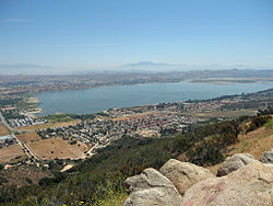
City of Lake Elsinore — City — View of Lake Elsinore and surrounding area 
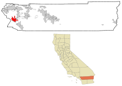
LogoLocation within Riverside County Coordinates: 33°40′53″N 117°20′43″W / 33.68139°N 117.34528°WCoordinates: 33°40′53″N 117°20′43″W / 33.68139°N 117.34528°W Country  United States
State  California
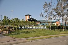
County Riverside Incorporated April 9, 1888 Government – Mayor Melissa A. Melendez – City Treasurer Allan Baldwin[1] Area[2] – Total 41.687 sq mi (107.970 km2) – Land 36.208 sq mi (93.779 km2) – Water 5.479 sq mi (14.19 km2) 13.14% Elevation 1,306 ft (395 m) Population (2010) – Total 51,821 – Density 1,243.1/sq mi (480/km2) Time zone PST (UTC-8) – Summer (DST) PDT (UTC-7) ZIP codes 92530-92532 Area code(s) 951 FIPS code 06-39486 GNIS feature ID 1652704 Website City of Lake Elsinore Lake Elsinore or LE is a city in western Riverside County, California. The population was 51,821 at the 2010 census. It is the home of the Lake Elsinore Storm baseball club of the California League which plays at the Lake Elsinore Diamond.
Contents
Geography
According to the United States Census Bureau, the city has a total area of 41.7 square miles (108.0 km²) of which 36.2 square miles (93.8 km²) of it is land and 5.5 square miles (14.2 km²), or 13.14%, is water.
Lake Elsinore, originally Laguna Grande, is the largest natural freshwater lake in Southern California and is situated at the lowest point within the 750-square-mile (1,900 km2) San Jacinto Watershed at the terminus of the San Jacinto River, where its headwaters are found on the western slopes of San Jacinto Peak with its North Fork, and Lake Hemet with its South Fork. Lake levels are healthy at 1,244 feet (above sea level) with a volume of 30,000 acre·ft (37,000,000 m3)[3] that often fluctuate, although much has been done recently to prevent the lake from drying up, flooding, or becoming stagnant. At 1,255 feet (383 m), the lake would spill into the outflow channel on its northeastern shore, known properly as Temescal Wash, flowing northwest along I-15, which feeds Temescal Creek, which dumps into the Santa Ana River just northwest of the City of Corona. It then flows to Orange County, out to the Pacific Ocean just south of Huntington State Beach.
Lake Elsinore is bordered by the Elsinore Mountains to the west, which are a part of the larger Santa Ana Mountain Range, and receive snowfall a few days each year. Included in the Santa Ana Mountains is the Cleveland National Forest and El Cariso. Lake Elsinore is a part of the Temecula Valley and northern portions are also considered part of Temescal Canyon.
Districts
Lake Elsinore is a city which encompasses a large geographical area. To better distinguish the wide range of neighborhoods, the city is organized into 12 districts. Each district beholds its own unique geography, culture, age, and history which together make Lake Elsinore a very diverse and culturally rich city. The neighborhoods are The Alberhill, Ballpark, Business, Countryclub Heights, East Lake, Historic, Lake Edge, Lake Elsinore Hills, Lake View, North Peak, Riverview Districts and Rosetta Canyon.
Demographics
2010
The 2010 United States Census[4] reported that Lake Elsinore had a population of 51,821. The population density was 1,243.1 people per square mile (480.0/km²). The racial makeup of Lake Elsinore was 31,067 (60.0%) White, 2,738 (5.3%) African American, 483 (0.9%) Native American, 2,996 (5.8%) Asian, 174 (0.3%) Pacific Islander, 11,174 (21.6%) from other races, and 3,189 (6.2%) from two or more races. Hispanic or Latino of any race were 25,073 persons (48.4%).
The Census reported that 51,389 people (99.2% of the population) lived in households, 224 (0.4%) lived in non-institutionalized group quarters, and 208 (0.4%) were institutionalized.
There were 14,788 households, out of which 8,026 (54.3%) had children under the age of 18 living in them, 8,735 (59.1%) were opposite-sex married couples living together, 2,071 (14.0%) had a female householder with no husband present, 1,155 (7.8%) had a male householder with no wife present. There were 1,165 (7.9%) unmarried opposite-sex partnerships, and 143 (1.0%) same-sex married couples or partnerships. 1,952 households (13.2%) were made up of individuals and 521 (3.5%) had someone living alone who was 65 years of age or older. The average household size was 3.48. There were 11,961 families (80.9% of all households); the average family size was 3.79.
The population was spread out with 16,990 people (32.8%) under the age of 18, 5,261 people (10.2%) aged 18 to 24, 15,731 people (30.4%) aged 25 to 44, 10,874 people (21.0%) aged 45 to 64, and 2,965 people (5.7%) who were 65 years of age or older. The median age was 29.8 years. For every 100 females there were 100.4 males. For every 100 females age 18 and over, there were 98.5 males.
There were 16,253 housing units at an average density of 389.9 per square mile (150.5/km²), of which 9,761 (66.0%) were owner-occupied, and 5,027 (34.0%) were occupied by renters. The homeowner vacancy rate was 4.6%; the rental vacancy rate was 6.8%. 32,891 people (63.5% of the population) lived in owner-occupied housing units and 18,498 people (35.7%) lived in rental housing units.
2000
As of the census[5] of 2000, there were 28,928 people, 8,817 households, and 6,877 families residing in the city. The population density was 855.7 people per square mile (330.4/km²). There were 9,505 housing units at an average density of 281.2 per square mile (108.6/km²). The racial makeup of the city was 65.6% White, 5.2% African American, 1.3% Native American, 2.1% Asian, 0.3% Pacific Islander, 20.3% from other races, and 5.2% from two or more races. Hispanic or Latino of any race were 38.1% of the population.
There were 8,817 households out of which 49.2% had children under the age of 18 living with them, 57.5% were married couples living together, 13.8% had a female householder with no husband present, and 22.0% were non-families. 16.2% of all households were made up of individuals and 5.5% had someone living alone who was 65 years of age or older. The average household size was 3.3 and the average family size was 3.7.
In the city the population was spread out with 36.0% under the age of 18, 9.3% from 18 to 24, 32.0% from 25 to 44, 16.0% from 45 to 64, and 6.7% who were 65 years of age or older. The median age was 29 years. For every 100 females there were 99.5 males. For every 100 females age 18 and over, there were 96.5 males.
In 2008 the median income for a household in the city was $56,440, and the median income for a family was $64,073.[6]
Climate
Lake Elsinore, generally has year-round pleasant weather:[7]
- On average, the warmest month is July.
- The highest recorded temperature was 115 °F (46 °C) in 1960.
- On average, the coolest month is December.
- The lowest recorded temperature was 10 °F (−12 °C) in 1974.
- The maximum average precipitation occurs in February.
Climate data for Lake Elsinore, California Month Jan Feb Mar Apr May Jun Jul Aug Sep Oct Nov Dec Year Average high °F (°C) 66
(19)68
(20)71
(22)77
(25)83
(28)91
(33)98
(37)98
(37)93
(34)84
(29)73
(23)67
(19)72 Average low °F (°C) 38
(3)40
(4)43
(6)46
(8)51
(11)56
(13)61
(16)62
(17)58
(14)51
(11)42
(6)37
(3)49 Precipitation inches (mm) 2.8
(71)2.96
(75.2)2.29
(58.2).56
(14.2).22
(5.6).02
(0.5).1
(3).12
(3).3
(8).36
(9.1).78
(19.8)1.58
(40.1)12.09
(307.1)Source: [8] Politics
In the state legislature Lake Elsinore is located in the 37th Senate District, represented by Republican Bill Emmerson, and in the 66th Assembly District, represented by Republican Kevin Jeffries. Federally, Lake Elsinore is located in California's 49th congressional district, which has a Cook PVI of R +10[9] and is represented by Republican Darrell Issa.
History
Native Americans have long lived in the area. The Luiseño were the earliest known inhabitants. Their pictographs can be found on rocks on the Santa Ana Mountains and in Temescal Valley and artifacts have been found all around Lake Elsinore and in the local canyons and hills.
Overlooked by the expedition of Juan Bautista de Anza, the largest natural lake in Southern California, was first seen by the Spanish Franciscan padre Juan Santiago, exploring eastward from the Mission San Juan Capistrano in 1797. In 1810, the water level of the Laguna Grande was first described by a traveler as being little more than a swamp about a mile long.[10] Later in the early 19th century the lake grew larger, providing a spot for Mexican rancheros, American trappers, the expedition of John C. Frémont and the immigrants during the California Gold Rush to camp and water their animals as they traveled along the southern shore of the lake on what later became the Southern Immigrant Trail and the route of the Butterfield Overland Mail.
On January 7, 1844, Julian Manriquez acquired the land grant to Rancho La Laguna a tract of almost 20,000 acres (81 km2) which included the lake, an adobe being built near the lake on its south shore at its western corner, which was described by Benjamin Ignatius Hayes who stayed there overnight January 27, 1850.[11]
In 1851 Abel Stearns acquired the rancho and sold it in 1858 to Augustin Machado. Augustin Machado built a seven room adobe ranch house and an outbuilding on the southwest side of the Lake, that stood until they were razed in 1964, at what is now 32912 Macy Avenue. Soon after Rancho La Laguna became a regular stop on the Butterfield Overland Mail route between Temecula 20 miles (32 km) to the south and the Temescal station 10 miles (16 km) to the north. Over the years a frame addition and frame second story had been added to it and it was used as the post office of the small settlement of Willard at the turn of the century. Today three palm trees still grow in front of the site along Macy Avenue in front of the property.[12][13]
As a result of the Great Flood of 1862, the level of the lake was very high and probably overflowed and that year the Union Army created a post at the lake to graze and water their horses. In the great 1862-65 drought, most of the cattle in Southern California died and the lake level fell, especially during 1866 and 1867, when practically no rain fell on the drainage area of the lake. However the lake was full again in 1872 when it overflowed down its outlet through Temescal Canyon.[14]
While and most of the old Californio families lost their Ranchos during the great drought, the La Laguna Rancho remained in the hands of the Machado family until 1873 when most of it was sold to an Englishman Charles A. Sumner. Juan Machado retained 500 acres (2.0 km2) on the northwest corner of the lake where his adobe still stands near the lake at 15410 Grand Avenue.
After 1872 the lake again evaporated to a very low level, but the great rains of the winter of 1883-84 filled it to overflowing in three weeks. Descriptions of the lake at this time say that large willow trees surrounding the low water shore line, growing 20 feet (6.1 m) or more below the high-water level when the lake filled in 1883-84, were of such size that they must have been thirty or more years old. This indicated that the high water of the 1860s and 1870s must have been of very short duration.[15]
On October 5, 1883, Franklin H. Heald and his partners Donald Graham and William Collier bought the remaining rancho intending to start a new town. In 1884 the California Southern Railroad built a line from Colton through the Cañon de Rio San Jacinto (now Railroad Canyon) to link with San Diego and a rail station La Laguna appeared near the corner of what is now Mission Trail Road and Diamond Drive. Lake Elsinore was incorporated as a city in San Diego County in 1888 and became part of Riverside County upon its creation in 1893 but was inhabited well before then. It was named Elsinore after the Danish city in Shakespeare's "Hamlet", which is now its sister city.
The rainfall until 1893 was greater than normal, and Lake Elsinore stayed high and overflowed naturally three or four years during that time. The lake water was purchased by the Temescal Water Company for the irrigation of lands at Corona, California, and its outlet channel was deepened, permitting gravity flow down the natural channel of Temescal Canyon to Corona for a year or more after the water level sank below the natural elevation of its outlet. As the lake surface continued to recede, a pumping plant was installed and pumping was continued a couple of seasons, but the concentration of salts in the lake, due to the evaporation and lack of rainfall, soon made the water unfit for irrigation and the project was abandoned by the company.[15]
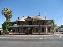
From the beginning, the mineral springs near the lake attracted visitors seeking therapeutic treatments. In 1887, the Crescent Bath House now known as "The Chimes" was built, it still stands in historic downtown and is a registered national historic site. By 1888, the economy was supported by coal and clay mining at what became the town of Terra Cotta, gold mining in the Pinacate Mining District, ranching and the agriculture of fruit and nuts.
After 1893 the lakes water level sank almost continuously for nearly ten years, with a slight rise every winter. Heavier precipitation, beginning in 1903, gradually filled the lake to about half the depth above its minimum level since 1883. Then in January, 1916, a flood rapidly raised the level to overflowing.[15]
In the 1920s Elsinore became a resort for the rich and the glamorous from Hollywood and also hosted teams for Olympic training and for high speed boat racing. The lake went dry in the mid 1930s but refilled by 1938. During World War II the lake was used to test seaplanes and a Douglas Aircraft plant making wing assemblies for B-17 bombers was located in the city.[16]
The lake ran dry during most of the 1950s and was refilled in the early 1960s. More than a week of heavy rains in 1980 flooded the lake, destroying surrounding homes and businesses. Since then there has been a multi-million dollar project put into place to maintain the water supply at a consistent level allowing for homes to be built close to the lake. Overflow water in the Lake spills out via Aberhill Creek, a tributary of Temescal Creek. In 2007 there was an aeration system added to help with the lake's ecosystem.
Lake Elsinore was a popular destination in the first half of the 1900s for celebrities to escape the urban Hollywood scene. Many of their homes still stand on the hills surrounding the lake, including Aimee's Castle (Aimee Semple McPherson), a uniquely shaped house perched on a hill above the water.
Despite its relatively small African-American population, it has the distinction of electing the first black mayor in the state of California. Tom Yarborough was elected in 1966, three years before Douglas Dollarhide became the mayor of Compton.
Rapid population growth altered the appearance and image of Lake Elsinore from a small lakeside town of 3,800 people in 1976 to a bedroom community of upper middle-class professionals. The city and its sphere of influence now has over 38,000 residents as of 2006 and formerly open hillsides have been converted into housing tracts that have nearly $500,000.00 homes. Alberhill and Rosetta Canyon being just two of the new housing areas.
Services
Public Safety
The Riverside County Sheriff's Department serves the entire Lake Elsinore Valley (including the nearby suburbs of Lakeland Village and Sedco Hills, and the newly-incorporated City of Wildomar) from its regional station in downtown Lake Elsinore (the city once had its own police department, but it was disbanded in 1979 for budgetary reasons).
The City of Lake Elsinore contracts for fire protection and emergency medical services(EMS) with the Riverside County Fire Department through a cooperative agreement with CAL FIRE (California Department of Forestry and Fire Protection). The City of Lake Elsinore currently has 3 paramedic engines operating out of its 3 stations and a 4th station currently under construction in Rosetta Canyon. The fire department also maintains a volunteer company which covers a rescue squad out of Station 94. The volunteers also cover reserve engines when the engines are available.
Fire station 10 is located downtown next to the post office which also has 2 Cal Fire engines for supplemental protection. Fire station 85 is located at McVicker Park and fire station 94 is located on the east side of the city off of Railroad Canyon Road. Rosetta Canyon station 97 will open sometime in the future.
Education
Public education within the most of the city of Lake Elsinore and the surrounding areas is provided by the Lake Elsinore Unified School District, which serves a student population of about 21,500.[17] The school district has 15 elementary schools, five middle schools, three high schools, and three alternative schools.[18]
A very small portion of northeastern Lake Elsinore in the Canyon Hills subdivision is located in the Menifee Union School District for grades K-8, and Perris Union High School District for grades 9-12.
Additionally, there are three private schools within the city of Lake Elsinore, including a K-12 preparatory academy.[19][20]
Cemetery
The Elsinore Valley Cemetery District[21] maintains a public cemetery in the city.[22][23] The cemetery was established in 1891 by Peter Wall.[24]
Lake Elsinore Diamond
Lake Elsinore Diamond serves as a site for the Single A baseball team of The Lake Elsinore Storm, which is a farm team for the San Diego Padres and was formerly a farm team for the Los Angeles Angels of Anaheim. Also, semi-pro football team, the Riverside-Elsinore Dolphins of the Western States Football League in 1996-98. The stadium now hosts the Banning-Elsinore Eagles of the California Football Association, a minor American football league. It may host the Murrieta Bandits, a professional soccer team in 2007, despite the team's office is based in Murrieta. At this time, neither football or soccer is played at "the Diamond". However, special events such as concerts with stars such as Willie Nelson and ZZ Top have appeared there.
(Lake) Elsinore Grand Prix
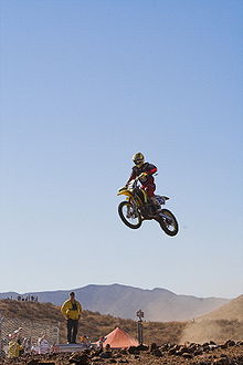
The Elsinore Grand Prix is a dirt bike race that takes place in and around the Lake Elsinore area. The annual race is usually held in mid-November. The popularity of the event hit its apex in the late 1960s and early 1970s drawing the likes of dirt bike greats such as Malcolm Smith and Steve McQueen to name a few. The race has always been set as an “open” format, meaning that anyone can ride, usually only about 200 or so take this event seriously, whereas the rest use it as an opportunity to have fun. In 1971 the documentary movie On Any Sunday by Bruce Brown included scenes from the grand prix.[25]
In the mid-1970s the Elsinore Grand Prix hit a snag, none of the big riders were participating and the event was drawing the wrong crowd, mostly violent motorcycle gangs. The grand prix was canceled indefinitely soon afterwards. In 1996 several dirt bike riders, with a hint of nostalgia, decided to lobby the City of Lake Elsinore to revive the Grand Prix. Promising that the violent motorcycle gang crowd drawn to the Grand Prix in the 1970s had gone and that dirt bike motorcycle riding was more of a family event, the city allowed the event to resume on a provisional basis.
In 1973 Honda named its CR-250M Elsinore—the first motorcycle designed by Honda for the dirt rather than a modified street bike—after the Elsinore GP race venue.[26]
Lake Elsinore is also a popular destination for motorcyclists riding east from San Juan Capistrano along the 33-mile (53 km) long Ortega Highway.[25]
Economy
One of the first outlet shopping malls in California was established in northwestern Lake Elsinore in the late 1990s on Collier Road at Nichols Road, just off Interstate 15; the mall now has its own automobile dealership. The mall has a wide variety of retailers, encompassing clothing and shoe stores, eateries, bookstores, perfumeries, home and garden boutiques, and electronics stores.[27]
The City's Visitors Bureau has also been making efforts to expand tourism in the area. Quality Inn, Best Western, and Holiday Inn Express hotels have recently been built within the city limits to accommodate tourists who attend the city's various events and enjoy the picturesque lake. Also Lake Elsinore Hotel & Casino has recently been remodeled to accommodate the growing need for hotel space in the region.
Top Employers
According to the City's 2009 Comprehensive Annual Financial Report,[28] the top employers in the city are:
# Employer # of Employees 1 Lake Elsinore Outlets 1,169 2 Lake Elsinore Unified School District 1,060 3 Costco 250 4 Walmart 225 5 Lowe's 200 6 The Home Depot 200 7 Target 200 8 Albertsons 195 9 Medley Communications 175 10 Lake Elsinore Storm 175 11 GBC Concrete and Masonry Construction 170 12 Stater Bros. 165 13 Pacific Clay 160 14 Lake Elsinore Hotel & Casino 130 15 Elsinore Valley Municipal Water District 120 References
- ^ California League of Cities, Elected City Treasurers
- ^ U.S. Census
- ^ http://www.swrcb.ca.gov/board_info/agendas/2002/july/0718-12.doc STATE WATER RESOURCES CONTROL BOARD
- ^ All data are derived from the United States Census Bureau reports from the 2010 United States Census, and are accessible on-line here. The data on unmarried partnerships and same-sex married couples are from the Census report DEC_10_SF1_PCT15. All other housing and population data are from Census report DEC_10_DP_DPDP1. Both reports are viewable online or downloadable in a zip file containing a comma-delimited data file. The area data, from which densities are calculated, are available on-line here. Percentage totals may not add to 100% due to rounding. The Census Bureau defines families as a household containing one or more people related to the householder by birth, opposite-sex marriage, or adoption. People living in group quarters are tabulated by the Census Bureau as neither owners nor renters. For further details, see the text files accompanying the data files containing the Census reports mentioned above.
- ^ "American FactFinder". United States Census Bureau. http://factfinder.census.gov. Retrieved 2008-01-31.
- ^ http://www.city-data.com/income/income-Lake-Elsinore-California.html
- ^ Lake Elsinore, CA: Weather Facts Retrieved 2009-05-07
- ^ "Lake Elsinore historic weather averages". Intellicast. http://www.intellicast.com/Local/History.aspx?location=USCA0580. Retrieved 20 July 2010.
- ^ "Will Gerrymandered Districts Stem the Wave of Voter Unrest?". Campaign Legal Center Blog. http://www.clcblog.org/blog_item-85.html. Retrieved 2008-02-10.
- ^ Water-supply paper, Volumes 425-429 By Geological Survey (U.S.), History of Elsinore Lake, p.255
- ^ Benjamin Ignatius Hayes, Edited and published by Marjorie Tisdale Wolcott, Pioneer notes from the diaries of Judge Benjamin Hayes, 1849-1875, Los Angeles, Priv. print., 1929. pp. 64-65
- ^ Mildred Brooke Hoover, Historic Spots in California, Third Edition, Stanford University Press, Stanford, 1966. p.390
- ^ Historical Topograpic Map, Elsinore, Edition Date: 1901, Scale 1/125000
- ^ Water-supply paper, Volumes 425-429 By Geological Survey (U.S.), History of Elsinore Lake, p.255]
- ^ a b c Water-supply paper, Volumes 425-429 By Geological Survey (U.S.), History of Elsinore Lake, p.255
- ^ Tom Hudson, Lake Elsinore Valley, its story 1776-1977, 2nd Ed., Published by author, 1988. ISBN 0-931700-01-9
- ^ Lake Elsinore Unified School District schools - district elementary, middle, and high school information
- ^ Lake Elsinore Unified School District
- ^ http://www.localschooldirectory.com/city-schools/Lake-Elsinore/CA
- ^ http://www.go2mountainside.com/
- ^ California Association of Public Cemeteries, Members
- ^ 33°41′40″N 117°20′29″W / 33.6944652°N 117.3414289°W USGS Geographic Names Information System (GNIS)
- ^ Elsinore Valley Cemetery Find A Grave
- ^ Shirley Brooks, "History of Elsinore Valley Cemetery", Lake Elsinore Genealogical Society accessdate=September 30, 2011
- ^ a b Richard Backus (March/April 2007). "Lake Elsinore, Calif., via the Ortega Highway". Motorcycle Classics. http://www.motorcycleclassics.com/touring-destination/2007-03-01/lake-elsinore-calif-via-the-ortega-hwy.aspx. Retrieved 2009-08-12.
- ^ "1973 CR250M by Honda - Bike Museum at Bob Logue Motorsports". http://www.hondamuseum.com/hallOfFame.asp?bike=HCR250M&name=1973%20CR250M. Retrieved 2010-06-02.
- ^ http://www.lakeelsinoreoutlet.com/index.cfm
- ^ City of Lake Elsinore, California Comprehensive Annual Financial Report, for the Year ended June 30, 2009
External links
- Lake Elsinore Official Site
- Lake Elsinore Valley Chamber of Commerce
- Lake Elsinore Unified School District Site

Temescal Valley Temescal Valley Temescal Valley
Canyon Lake
Lakeland Village
Unincorporated Riverside County
Canyon Lake  Lake Elsinore

Unincorporated Riverside County
El CarisoWildomar Menifee Municipalities and communities of Riverside County, California Cities Banning | Beaumont | Blythe | Calimesa | Canyon Lake | Cathedral City | Coachella | Corona | Desert Hot Springs | Eastvale | Hemet | Indian Wells | Indio | Jurupa Valley | La Quinta | Lake Elsinore | Menifee | Moreno Valley | Murrieta | Norco | Palm Desert | Palm Springs | Perris | Rancho Mirage | Riverside | San Jacinto | Temecula | Wildomar
CDPs Aguanga | Anza | Bermuda Dunes | Cabazon | Cherry Valley | Coronita | Crestmore Heights | Desert Center | Desert Edge | Desert Palms | East Hemet | El Cerrito | El Sobrante | French Valley | Garnet | Glen Avon | Good Hope | Green Acres | Highgrove | Home Gardens | Homeland | Idyllwild-Pine Cove | Indio Hills | Lake Mathews | Lake Riverside | Lakeland Village | Lakeview | March ARB | Mead Valley | Meadowbrook | Mecca | Mesa Verde | Mira Loma | Mountain Center | North Shore | Nuevo | Oasis | Pedley | Ripley | Romoland | Rubidoux | Sky Valley | Sunnyslope | Temescal Valley | Thermal | Thousand Palms | Valle Vista | Vista Santa Rosa | Warm Springs | Whitewater | Winchester | Woodcrest
Unincorporated
communitiesAlberhill | Alessandro | Arcilla | Arnold Heights | Belltown | Biskra Palms | Bly | Bonnie Bell | Box Springs | Cactus City | Cahuilla | Cahuilla Hills | Chiriaco Summit | East Blythe | Edgemont | El Cariso | Gilman Hot Springs | La Cresta | Lost Lake | Mortmar | Murrieta Hot Springs | River Bend Lodge | Sun City Palm Desert
Indian
reservationsAgua Caliente Indian Reservation | Cabazon Indian Reservation | Cahuilla Reservation | Colorado River Indian Reservation | Los Coyotes Reservation | Morongo Reservation | Ramona Indian Reservation | Santa Rosa Indian Reservation | Soboba Reservation | Torres-Martinez Indian Reservation
Ghost towns Alamo Bonito | Auld | Bergman | Caleb | Eagle Mountain | Hell | La Placita | Midland | Pinacate | Saahatpa | Terra Cotta
Categories:- Lake Elsinore, California
- Cities in Riverside County, California
- Incorporated cities and towns in California
- Inland Empire (California)
- Populated places in the United States with Hispanic plurality populations
Wikimedia Foundation. 2010.

