- Ontario, California
-
City of Ontario — City — 
SealNickname(s): The Gateway to Southern California Location within San Bernardino County in the state of California
Coordinates: 34°03′10″N 117°37′40″W / 34.05278°N 117.62778°WCoordinates: 34°03′10″N 117°37′40″W / 34.05278°N 117.62778°W Country  United States
State  California
County San Bernardino Government – Type Council-Manager – City Council Mayor Paul S. Leon
Jim Bowman
Alan D. Wapner
Sheila Mautz
Debra Dorst-Porada– City Treasurer James R. Milhiser – City Clerk Mary E. Wirtes, MMC – City Manager Chris Hughes Area[1] – Total 50.006 sq mi (129.515 km2) – Land 49.941 sq mi (129.345 km2) – Water 0.065 sq mi (0.170 km2) 0.13% Elevation 925 ft (282 m) Population (2010) – Total 163,924 – Rank 4th in San Bernardino County
29th in California
144th in the United States– Density 3,278.1/sq mi (1,265.7/km2) Time zone PST (UTC-8) – Summer (DST) PDT (UTC-7) ZIP codes 91758, 91761-91762, 91764 Area code(s) 909 FIPS code 06-53896 GNIS feature ID 1652764 Website www.ci.ontario.ca.us Ontario is a city located in San Bernardino County, California, United States, 35 miles east of downtown Los Angeles. Located in the western part of the Inland Empire region, it lies just east of the Los Angeles county line and is part of the Greater Los Angeles Area. As of the 2010 Census, the city had a population of 163,924, down from 170,373 at the 2000 census, making it the county's fourth most populous city after San Bernardino, Fontana, and Rancho Cucamonga.
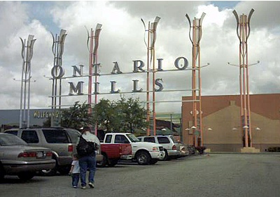
The city is home to the LA/Ontario International Airport which is the 15th busiest cargo airport in the United States. Ontario handles the mass of freight traffic between the ports of Los Angeles and Long Beach and the rest of the country.[2] It is also the home of Ontario Mills and former home of the Ontario Motor Speedway.
It takes its name from the Ontario Model Colony development established in 1882 by the Canadian engineer George Chaffey and his brothers William Chaffey and Charles Chaffey.[3] They named the settlement after their home province of Ontario, Canada.
Contents
History
The area that is now Ontario was part of the lands used for hunting and foraging by the semi-nomadic Tongva Serrano (Gabrieleño) Indians, who were known to roam as far south as the western San Bernardino Mountains. At the time of Mexican and later of American settlement, active Native American settlements were scattered across the entire valley. Remains of a Serrano village were discovered in the neighboring foothills of the present-day city of Claremont.
Juan Bautista de Anza friend of the land owner of Rancho Cucamonga [located at Township 1 South Range 7 West], Tiburcio Tapia, leaving him the assistance of the Cahuilla Indians from Anza, whom were under no control of any Spanish establishments. Other than the street and middle school named after De Anza, the only other artifact representing this expedition of De Anza and the Cahullia Tribe is a structure (still standing at 1007 East Main Street in the city's current Quiet Home Acquisition Project Area) and is not currently recognized for its significance. Following the 1819 establishment of San Bernardino Asistencia, which may have served as an outpost of the San Gabriel mission, it became part of a large, vaguely identified area called "San Antonio".
In 1826, Jedediah Smith passed through what is now Upland on the first overland journey to the West coast of North America via the National Old Trails Highway (present-day Foothill Blvd).
The 1834 secularization of California land holdings resulted in the land's transferral to private hands. In 1881, the Chaffey brothers purchased the land (which at that time also included the present-day city of Upland) and the water rights to it. They engineered a drainage system channeling water from the foothills of Mount Baldy down to the flatter lands below that performed the dual functions of allowing farmers to water their crops and preventing the floods that periodically afflict them. They also created the main thoroughfare of Euclid Avenue (California Highway 83), with its distinctive wide lanes and grassy median. The new "Model Colony" (called so because it offered the perfect balance between agriculture and the urban comforts of schools, churches, and commerce) was originally conceived as a dry town, early deeds containing clauses forbidding the manufacture or sale of alcoholic beverages within the town. The two named the town "Ontario" because they originally hailed from Ontario, Canada.
Ontario attracted farmers (primarily citrus) and ailing Easterners seeking a drier climate. To impress visitors and potential settlers with the "abundance" of water in Ontario, a fountain was placed at the Southern Pacific railway station. It was turned on when passenger trains were approaching and frugally turned off again after their departure. The original "Chaffey fountain," a simple spigot surrounded by a ring of white stones, was later replaced by the more ornate "Frankish Fountain," an Art Nouveau creation now located outside the Ontario Museum of History and Art.
Agriculture was vital to the early economy, and many street names recall this legacy. The Sunkist plant also remains as a living vestige of the citrus era. The Chaffey brothers left to found the settlements of Mildura, Australia and Renmark, Australia which met with varying success. Charles Frankish continued their work at Ontario.
Mining engineer John Tays refined the design of the novel "mule car," used from 1887 for public transportation on Euclid Avenue to 24th Street. At that point, the two mules were loaded onto a platform at the rear of the car and allowed to ride, as gravity propelled the trolley back down the avenue to the downtown Ontario terminus. Soon replaced by an electric streetcar, the mule car is commemorated by a replica in an enclosure south of C Street on the Euclid Avenue median.
Ontario was incorporated as a city in 1891, and North Ontario broke away in 1906, calling itself Upland. Ontario grew at an astronomical rate, increasing 10 times in the next half a century. The population of 20,000 in the 1960s again grew 10 times more by the year 2007. Ontario was viewed as an "Iowa under Palm trees," with a solid Midwestern/Mid-American foundation, but it had a large German and Swiss community. Tens of thousands of European immigrants came to work in agriculture, and in the early 1900s the first Filipinos and Japanese farm laborers arrived, later to display nursery ownership skills.
Ontario has over two centuries of Hispanic residents from the Californio period of Spanish colonial and Mexican rule in the 1840s, but the first wave of Mexican settlers was in the 1880s brought as workers in the railroad industry (see traquero) and another wave from the Mexican Revolution of the 1910s. Mexican Americans resided in the city's poorer southern side facing State Route 60 and Chino.
Economy
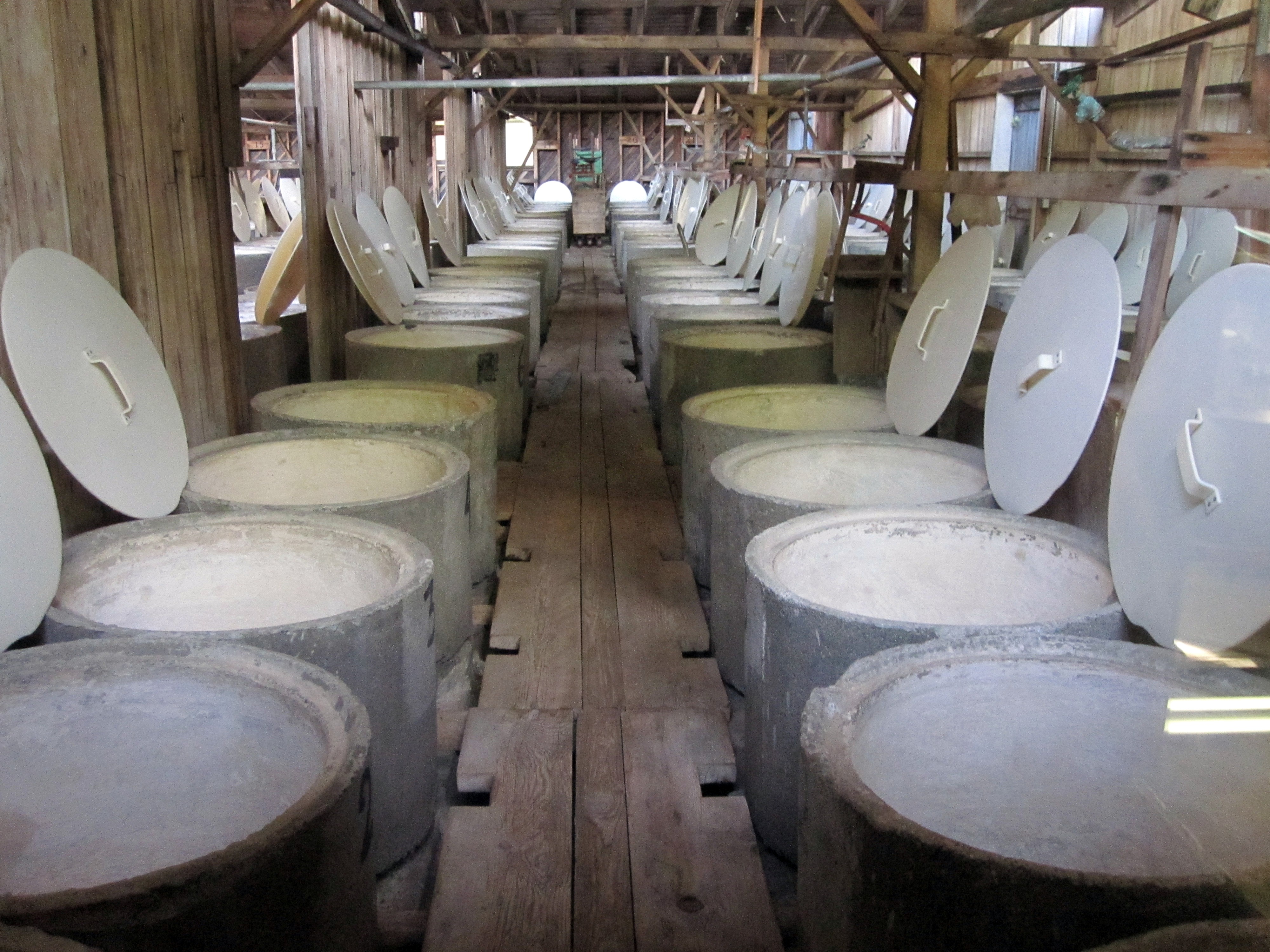
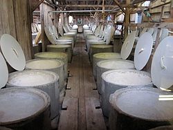 The olive vat room at Graber Olive House in Ontario, California. In 1894, two years after planting olive trees in Ontario, C. C. Graber began selling vat cured olives from the pictured vat room in vats similar to the ones pictured. Graber Olive House is the oldest operating olive packer in the United States.
In the years following Ontario's founding, the economy was driven by its reputation as a health resort. Shortly thereafter, citrus farmers began taking advantage of Ontario's rocky soil to plant lemon and orange groves. Agricultural opportunities also attracted vintners and olive growers. The Graber Olive House, which continues to produce olives, is a city historical landmark and one of the oldest institutions in Ontario. Dairy farming is also prevalent, as it continues to be in neighboring Chino.
A major pre-war industry was the city's General Electric plant that produced clothing irons. During and after World War II, Ontario experienced a housing boom common to many suburbs. The expansion of the Southern California defense industry attracted many settlers to the city.
Today, Ontario still has a manufacturing industry, the most notable of which is the Maglite corporation, which produces flashlights there. However, manufacturing has waned, and today Ontario's economy is dominated by service industries and warehousing. Much of southern Ontario still contains dairy farms and other agricultural farms. However, the area is currently under planning to be developed into a mixed-use area of residential homes, industrial and business parks, and town centers, collectively known as the New Model Colony.
Ontario is also home to the Famous Stars and Straps clothing company and to Shiekh Shoes.
Top employers
According to the City's 2009 Comprehensive Annual Financial Report,[4] the top employers in the city are:
# Employer # of Employees 1 LA/Ontario International Airport 7,690 2 United Parcel Service (UPS) 3,500 3 Pro’s Ranch Markets 1,575 4 City of Ontario 1,068 5 U.S. Merchants 1,000 6 Mag Instrument 900 7 Citizens Business Bank 719 8 The Icee Company 700 9 Marriott 624 10 Toyota 530 Entertainment and performing arts
 The Granada Theatre. Circa 1940
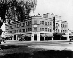
Built in 1925, it was leased to West Coast Junior Theater and by the 1940s was part of Fox West Coast Theater chain. The Granada Theater was designed by noted architect L.A. Smith.
Sports
 Ontario Reign LW#7 Todd Jackson
The Citizens Business Bank Arena is a sports arena which opened in late 2008. It is owned by Ontario, but is operated by Anschutz Entertainment Group. It is an 11,000-seat multi-purpose arena, and is home to the Ontario Reign, a team in the ECHL. It is the largest enclosed arena in the Inland Empire.
The first year Los Angeles Kings affiliate plays at the 9,736 -seat Citizens Business Bank Arena. Ontario has posted a respectable 5,207 per game average (5th) in a very crowded southern California entertainment market. Minor league teams often have to build a following with success over time, but Ontario Reign fans have offered strong support of this team right out of the gate.
Ontario was recently announced as the host of the 2010 ECHL Allstar Game. Ontario joins Stockton (2008), Fresno (2006), and Bakersfield (2011) as California franchises hosting the league's midseason showcase. The minor league ASG is expected to pump more than $1 million dollars into the local economy.
Traditions
Since 1959, Ontario has placed three-dimensional nativity scenes from the life of Jesus on the median of Euclid Avenue during the Christmas season. The scenes, featuring statues by the sculptor Rudolpho Vargas, were challenged in the 1998 as a violation of church-state separation under the California Constitution by atheist resident Patrick Greene, but the dispute was resolved when private organizations began funding the storage and labor involved in the set-up and maintenance of the scenery in its entirety.[5] As means to support the nativity scenes the Ontario Chamber of Commerce started "Christmas on Euclid". This is a craft fair extravaganza is held the first Saturday in December. High end artist/merchants come to sell their creations. The Ontario Rotary also participates in this event by having a classic car show that raises money for the library. Euclid Avenue is closed to traffic from "G" street to Holt for area residents to enjoy shopping for Christmas present and having a delicious meal. In 2009 the Ontario Kiwanis took over management of the event. The All-States Picnic, an Independence Day celebration, began in 1939 to recognize the varied origins of the city's residents. Picnic tables lined the median of Euclid Avenue from Hawthorne to E Street, with signs for each of the country's 48 states. The picnic was suspended during World War II, but when it resumed in 1948, it attracted 120,000 people. A 1941 Ripley's Believe It or Not! cartoon listed Ontario's picnic table as the "world's longest." As native Californians came to outnumber the out-of-state-born, the celebration waned in popularity until it was discontinued in 1981. It was revived in 1991 as a celebration of civic pride.[6] For over 50 years the first Saturday in June the Ontario Kiwanis and the Ontario Rotary partner for the annual "Pancake Breakfast and Car Show". Over 10,000 inland empire resident's come to eat delicious pancakes and view the over 400 cars that come to show off their gorgeous paint jobs and hope appreciate all the hard work they put into the cars.
Geography
Ontario is located at 34°3' North, 117°38' West (34.05, -117.63).[7]
According to the United States Census Bureau, the city has a total area of 50.0 square miles (129 km2). Of that, 49.9 square miles (129 km2) is land and 0.1 square miles (0.26 km2) is water. The total area is 0.13% water.
Surrounding municipalities
Destinations from Ontario 
Montclair Upland Rancho Cucamonga Pomona 
Fontana  Ontario

Chino Eastvale Jurupa Valley Climate
Climate data for Ontario Month Jan Feb Mar Apr May Jun Jul Aug Sep Oct Nov Dec Year Record high °F (°C) 93
(34)92
(33)97
(36)102
(39)112
(44)111
(44)114
(46)111
(44)117
(47)108
(42)96
(36)93
(34)117
(47)Average high °F (°C) 68
(20)69
(21)71
(22)76
(24)79
(26)84
(29)90
(32)92
(33)89
(32)80
(27)74
(23)68
(20)78.3 Average low °F (°C) 43
(6)45
(7)47
(8)49
(9)54
(12)58
(14)62
(17)62
(17)60
(16)55
(13)47
(8)42
(6)52.0 Record low °F (°C) 22
(−6)28
(−2)30
(−1)30
(−1)35
(2)42
(6)48
(9)48
(9)44
(7)33
(1)30
(−1)23
(−5)22
(−6)Precipitation inches (mm) 3.11
(79)4.26
(108.2)2.63
(66.8)1.20
(30.5).23
(5.8).09
(2.3).00
(0).03
(0.8).15
(3.8)1.05
(26.7)1.62
(41.1)2.45
(62.2)16.82
(427.2)Source: [8] Demographics
Historical populations Census Pop. %± 1890 683 — 1900 722 5.7% 1910 4,274 492.0% 1920 7,280 70.3% 1930 13,583 86.6% 1940 14,197 4.5% 1950 22,872 61.1% 1960 46,617 103.8% 1970 64,118 37.5% 1980 88,820 38.5% 1990 133,179 49.9% 2000 170,373 27.9% 2010 163,924 −3.8% 2010
After a long period of growth, Ontario showed a population decline between the 2000 and 2010 censuses.
The 2010 United States Census[9] reported that Ontario had a population of 163,924. The population density was 3,278.1 people per square mile (1,265.7/km²). The racial makeup of Ontario was 83,683 (51.0%) White, 10,561 (6.4%) African American, 1,686 (1.0%) Native American, 8,453 (5.2%) Asian, 514 (0.3%) Pacific Islander, 51,373 (31.3%) from other races, and 7,654 (4.7%) from two or more races. Hispanic or Latino of any race were 113,085 persons (69.0%).
The Census reported that 163,166 people (99.5% of the population) lived in households, 411 (0.3%) lived in non-institutionalized group quarters, and 347 (0.2%) were institutionalized.
There were 44,931 households, out of which 23,076 (51.4%) had children under the age of 18 living in them, 23,789 (52.9%) were opposite-sex married couples living together, 7,916 (17.6%) had a female householder with no husband present, 3,890 (8.7%) had a male householder with no wife present. There were 3,470 (7.7%) unmarried opposite-sex partnerships, and 384 (0.9%) same-sex married couples or partnerships. 6,741 households (15.0%) were made up of individuals and 2,101 (4.7%) had someone living alone who was 65 years of age or older. The average household size was 3.63. There were 35,595 families (79.2% of all households); the average family size was 3.98.
The population was spread out with 49,443 people (30.2%) under the age of 18, 19,296 people (11.8%) aged 18 to 24, 49,428 people (30.2%) aged 25 to 44, 34,703 people (21.2%) aged 45 to 64, and 11,054 people (6.7%) who were 65 years of age or older. The median age was 29.9 years. For every 100 females there were 99.0 males. For every 100 females age 18 and over, there were 96.8 males.
There were 47,449 housing units at an average density of 948.9 per square mile (366.4/km²), of which 24,832 (55.3%) were owner-occupied, and 20,099 (44.7%) were occupied by renters. The homeowner vacancy rate was 2.0%; the rental vacancy rate was 5.8%. 90,864 people (55.4% of the population) lived in owner-occupied housing units and 72,302 people (44.1%) lived in rental housing units.
2000
As of the census[10] of 2000, there were 158,007 people, 43,525 households, and 34,689 families residing in the city. The population density was 3,173.9 inhabitants per square mile (1,225.5/km²). There were 45,182 housing units at an average density of 907.6 per square mile (350.4/km²). The racial makeup of the city was 47.8% White, 7.5% African American, 1.1% Native American, 3.9% Asian, 0.4% Pacific Islander, 34.1% from other races and 5.3% were from two or more races. 59.9% were Hispanic or Latino of any race.
There were 43,525 households out of which 49.4% had children under the age of 18 living with them, 56.9% were married couples living together, 15.5% had a female householder with no husband present, and 20.3% were non-families. 15.1% of all households were made up of individuals and 4.6% had someone living alone who was 65 years of age or older. The average household size was 3.6 and the average family size was 4.0.
In the city the population was spread out with 34.4% under the age of 18, 11.2% from 18 to 24, 32.4% from 25 to 44, 16.1% from 45 to 64, and 5.9% who were 65 years of age or older. The median age was 28 years. For every 100 females there were 100.6 males. For every 100 females age 18 and over, there were 98.7 males.
The median income for a household in the city was $42,452, and the median income for a family was $44,031. Males had a median income of $31,664 versus $26,069 for females. The per capita income for the city was $14,244. 15.5% of the population and 12.2% of families were below the poverty line. 19.1% of those under the age of 18 and 7.6% of those 65 and older were living below the poverty line.
Government
Local government
The city is governed by a five-member council: Mayor Paul Leon, who was elected as mayor in 2005, re-elected in November 2006 and is the first Hispanic to serve in that position in the history of Ontario, Mayor pro tem Debra Dorst-Porada, Alan Wapner, Jim Bowman and Sheila Mautz. Councilmembers Bowman and Wapner being the longest tenured members on the council both with 17 years in office. Councilmember Bowman being the only member of the council that is a lifelong resident of Ontario.(66 years)
 The Ontario City Library following its 2006 reopening after extensive remodeling
According to the city’s most recent Comprehensive Annual Financial Report, the city's various funds had $399.4 million in revenues, $305.3 million in expenditures, $1,606.0 million in total assets, $317.6 million in total liabilities, and $412.4 million in cash and investments.[11]
The structure of the management and coordination of city services is:[12]
City Department Director City Manager Chris Hughes Deputy City Manager Al C. Boling City Attorney John E. Brown Administrative Services / Finance Director Grant D. Yee Development Director Otto Kroutil Public Works / Community Services Director Mohamed El-Amany / Mark Chase Fire Chief Dave Carrier Police Chief Eric Hopley Housing and Neighborhood Revitalization Director Brent D. Schultz Economic Development Director John Andrews Redevelopment Director John Andrews Politics
In the state legislature Ontario is located in the 32nd Senate District, represented by Democrat Gloria Negrete McLeod, and in the 61st Assembly District, represented by Democrat Norma Torres. Federally, Ontario is located in California's 43rd congressional district, which has a Cook PVI of D +13[13] and is represented by Democrat Joe Baca.
Education
Ontario has 25 public elementary schools, six public middle schools and five public high schools under the combined oversight of four school districts. There are also several private schools throughout the city as well as two private military schools. Ontario also has nine trade schools. Providence Christian College, a four-year Christian liberal arts college, opened in 2005. The University of La Verne College of Law and Chaffey College Ontario Campus are located in downtown Ontario. National University and Chapman University have a satellite campus near the Ontario Mills mall.
Transportation
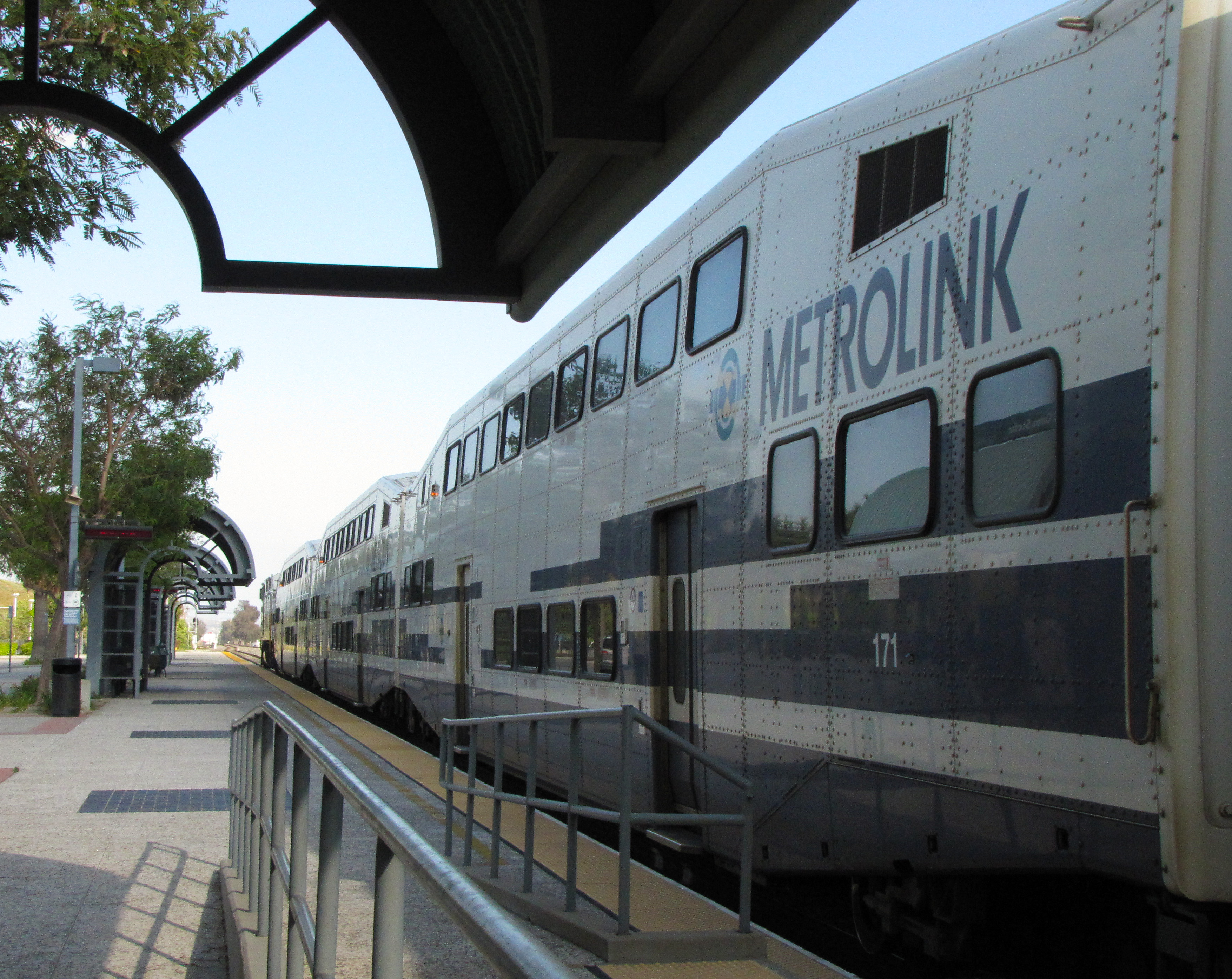
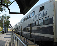 A Metrolink train at the East Ontario Station
The LA/Ontario International Airport provides domestic and limited international air travel. Because of the many manufacturing companies and warehouses in the city, the airport also serves as a major hub for freight, especially for FedEx and UPS. This airport is owned by the city of Los Angeles.
Because Ontario is a major hub for passengers and freight, the city is also served by several major freeways. Interstate 10 and the Pomona Freeway (State Route 60) run east-west through the city. Interstate 10 is north of the Ontario airport while the Pomona freeway is south of the airport. Interstate 15 runs in the north-south directions at the eastern side of the city. State Route 83, also known as Euclid Avenue, also runs in the north-south direction at the western side of the city.
Ontario also has a Metrolink station off of Haven Avenue. It connects Ontario with much of the Greater Los Angeles area, Orange County and the San Fernando Valley. Public bus transportation is provided by Omnitrans.
Tourism
The Ontario Mills mall is home to the only Kenny Rogers Roasters still operating within the United States.
Sister cities
Ontario has four sister cities around the world.[14] They are:
 Brockville, Ontario, Canada (since 1977)
 Guamuchil, Sinaloa, Mexico (since 1982)
- Mocorito, Sinaloa, Mexico (since 1982)
 Winterthur, Switzerland (since 1982)
Notable residents
- Hobie Alter, pioneer surfboard maker and catamaran builder
- Rod Barajas, MLB player for the Los Angeles Dodgers
- Jim Brulte, politician [15]
- Henry Bumstead, Academy Award-winning cinematic art director and designer
- Beverly Cleary, Author and Newbery Medal award winning Novelist.(1984),The Luckiest Girl and memoir My Own Two Feet
- Cle Kooiman, former soccer player
- Harry Chamberlin, inventor of the Chamberlin electro-mechanical keyboard[16]
- Del Crandall, former MLB player
- Landon Donovan, MLS player for the Los Angeles Galaxy and formerly Everton of the Premier League
- Prince Fielder, player for the Milwaukee Brewers
- Ana Patricia González, winner of Nuestra Belleza Latina 2010 (Our Latin Beauty 2010)[citation needed]
- Robert Graettinger, composer
- Alan Haskvitz, National Teachers Hall of Fame inductee, educator and author[17]
- Nick Leyva, former manager of the Philadelphia Phillies (1989–1991)[18]
- Christina "T" Lopez, singer, actress; former member of Latin girl dance-pop band Soluna[19]
- Anthony Muñoz, 1998 Pro Football Hall of Fame inductee
- Al Newman, former MLB player [20]
- Douglas Northway, Olympic bronze medalist, swimming[21]
- Joan O'Brien, Actress, graduate of Chaffey Union High School District.
- Joey Scarbury, singer[22]
- Robert Shaw, conductor[23]
- Mike Sweeney, MLB player for the Philadelphia Phillies, attended Ontario High School and led their baseball team to an undefeated record in 1991 which led to the state CIF title[24]
- Joseph Wambaugh, author[25]
- Frank Zappa, musician and composer
- Antonio Pierce, American Football player
References
- ^ U.S. Census
- ^ Ontario: Inland Empire Urban Center
- ^ History of Ontario Retrieved 2010-05-12.
- ^ City of Ontario CAFR
- ^ chaffey.org
- ^ dailybulletin.com
- ^ "US Gazetteer files: 2010, 2000, and 1990". United States Census Bureau. 2011-02-12. http://www.census.gov/geo/www/gazetteer/gazette.html. Retrieved 2011-04-23.
- ^ "Ontario average weather". Weather. http://www.weather.com/outlook/health/fitness/wxclimatology/monthly/graph/USCA0806. Retrieved 2011-10-08.
- ^ All data are derived from the United States Census Bureau reports from the 2010 United States Census, and are accessible on-line here. The data on unmarried partnerships and same-sex married couples are from the Census report DEC_10_SF1_PCT15. All other housing and population data are from Census report DEC_10_DP_DPDP1. Both reports are viewable online or downloadable in a zip file containing a comma-delimited data file. The area data, from which densities are calculated, are available on-line here. Percentage totals may not add to 100% due to rounding. The Census Bureau defines families as a household containing one or more people related to the householder by birth, opposite-sex marriage, or adoption. People living in group quarters are tabulated by the Census Bureau as neither owners nor renters. For further details, see the text files accompanying the data files containing the Census reports mentioned above.
- ^ "American FactFinder". United States Census Bureau. http://factfinder.census.gov. Retrieved 2008-01-31.
- ^ City Ontario CAFR Retrieved 2009-08-14
- ^ City of Ontario CAFR Retrieved 2009-08-14
- ^ "Will Gerrymandered Districts Stem the Wave of Voter Unrest?". Campaign Legal Center Blog. http://www.clcblog.org/blog_item-85.html. Retrieved 2008-02-10.
- ^ http://www.ci.ontario.ca.us/index.cfm/21956/11049
- ^ chaffey.org
- ^ [1]
- ^ chaffey.org
- ^ [2]
- ^ http://www.qvmagazine.com/qv29/soluna.html Soluna On Fire The Girls Of Soluna Like Us—They Really Do! - QV Magazine
- ^ Al Newman Statistics - The Baseball Cube
- ^ http://www.sports-reference.com/olympics/athletes/no/doug-northway-1.html Doug Northway Biography and Statistics
- ^ Joey Scarbury, born in Ontario, California, singer, Greatest American Hero June 7 in History
- ^ Alumni Hall of Fame
- ^ mikesweeney.org
- ^ chaffey.org
External links
- Chamber of Commerce
- Official City Website
- Convention & Visitors Bureau
- Ontario, California at the Open Directory Project
- “The Frankish Building: A Reflection of the Success of Ontario, California”, a National Park Service Teaching with Historic Places (TwHP) lesson plan
Categories:- Cities in San Bernardino County, California
- Populated places in California with Hispanic majority populations
- Ontario, California
- Incorporated cities and towns in California


Wikimedia Foundation. 2010.