- Santa Cruz County, California
-
County of Santa Cruz — County — 
SealLocation in the state of California California's location in the United States
Country United States State California Incorporated 1850 County seat Santa Cruz Area – Total 607.16 sq mi (1,572.5 km2) – Land 445.24 sq mi (1,153.2 km2) – Water 161.92 sq mi (419.4 km2) Population (2010) 262,382 – Density 589.3/sq mi (227.5/km2) Time zone Pacific Standard Time (UTC-8) – Summer (DST) Pacific Daylight Time (UTC-7) Website www.co.santa-cruz.ca.us Santa Cruz County is a county located on the Pacific coast of the U.S. state of California, on the California Central Coast. The county forms the northern coast of the Monterey Bay. (Monterey County forms the southern coast). As of the 2010 U.S. Census, its population was 262,382. The county seat is Santa Cruz. Santa Cruz County is a member of the regional governmental agency Association of Monterey Bay Area Governments and is one of 11 counties in the U.S. Census Bureau's definition of the San Francisco Bay Area Combined Statistical Area.
Contents
History
Santa Cruz County was one of the original counties of California, created in 1850 at the time of statehood.
In the original act, the county was given the name of "Branciforte" after the Spanish pueblo founded there in 1797; a major watercourse in the county, Branciforte Creek, bears this name. Less than two months later, the name was changed to "Santa Cruz" ("Holy Cross"). Mission Santa Cruz, established in 1791 and completed in 1794, was destroyed by an earthquake in 1857, but a smaller-scale replica was erected in 1931.
Geography
According to the 2000 census, the county has a total area of 607.16 square miles (1,572.5 km2), of which 445.24 square miles (1,153.2 km2) (or 73.33%) is land and 161.92 square miles (419.4 km2) (or 26.67%) is water.[1] Of California's counties, only San Francisco is physically smaller.
The county is a strip about ten miles (16 km) wide between the coast and the crest of the Santa Cruz Mountains at the northern end of the Monterey Bay. It can be divided roughly into four regions: the rugged "north coast"; the urban City of Santa Cruz, Soquel, Capitola, and Aptos; mountainous Bonny Doon, San Lorenzo River Valley; and fertile "south county", including Watsonville. Agriculture is concentrated in the coastal lowlands of the county's northern and southern ends. Most of the coastline is flanked by cliffs.
Cities and towns
Incorporated Cities:
Non-incorporated Towns and Communities:
Adjacent counties
 Santa Cruz
Counties and bodies of water adjacent to Santa Cruz County, California Transportation infrastructure
Major highways
 State Route 1
 State Route 9
 State Route 17
 State Route 35
 State Route 129
 State Route 152
 State Route 236
County routes
Public transportation
Santa Cruz County is served by the Santa Cruz Metropolitan Transit District bus system. A "Highway 17 Express" bus between Santa Cruz and San Jose is jointly operated by the SCMTD and the Santa Clara Valley Transportation Authority. Greyhound Lines bus service also serves Santa Cruz County.
Airports
Watsonville Municipal Airport is a public general aviation airport. There are two air carriers based at the airport offering on-demand air charter:
There is a notable private airport, Monterey Bay Academy Airport, which is a former military base.
The nearest airports for scheduled commercial travel include San Jose International Airport, Monterey Peninsula Airport, San Francisco International Airport, and Oakland International Airport.
Demographics
Historical populations Census Pop. %± 1850 643 — 1860 4,944 668.9% 1870 8,743 76.8% 1880 12,802 46.4% 1890 19,270 50.5% 1900 21,512 11.6% 1910 26,140 21.5% 1920 26,269 0.5% 1930 37,433 42.5% 1940 45,057 20.4% 1950 66,534 47.7% 1960 84,219 26.6% 1970 123,790 47.0% 1980 188,141 52.0% 1990 229,734 22.1% 2000 255,602 11.3% 2010 262,382 2.7% 2010
The 2010 United States Census reported that Santa Cruz County had a population of 262,382. The racial makeup of Santa Cruz County was 190,208 (72.5%) White, 2,766 (1.1%) African American, 2,253 (0.9%) Native American, 11,112 (4.2%) Asian, 349 (0.1%) Pacific Islander, 43,376 (16.5%) from other races, and 12,318 (4.7%) from two or more races. Hispanic or Latino of any race were 84,092 persons (32.0%).[4]
Population reported at 2010 United States Census The County Total
PopulationWhite African
AmericanNative
AmericanAsian Pacific
Islanderother
racestwo or
more racesHispanic
or Latino
(of any race)Santa Cruz County 262,382 190,208 2,766 2,253 11,112 349 43,376 12,318 84,092 Incorporated
cities and townsTotal
PopulationWhite African
AmericanNative
AmericanAsian Pacific
Islanderother
racestwo or
more racesHispanic
or Latino
(of any race)Capitola 9,918 7,963 123 59 424 10 869 470 1,957 Santa Cruz 59,946 44,661 1,071 440 4,591 108 5,673 3,402 11,624 Scotts Valley 11,580 9,958 101 57 590 18 292 564 1,158 Watsonville 51,199 22,399 358 629 1,664 40 23,844 2,265 41,656 Census-designated
placesTotal
PopulationWhite African
AmericanNative
AmericanAsian Pacific
Islanderother
racestwo or
more racesHispanic
or Latino
(of any race)Amesti 3,478 1,889 12 41 89 1 1,309 137 2,273 Aptos 6,220 5,420 58 43 247 8 175 269 611 Aptos Hills-Larkin Valley 2,381 1,936 12 5 55 1 295 77 541 Ben Lomond 6,234 5,692 32 51 70 11 98 280 515 Bonny Doon 2,678 2,474 9 15 51 5 48 76 168 Boulder Creek 4,923 4,429 54 31 81 5 119 204 366 Brookdale 1,991 1,790 9 12 19 8 66 87 202 Corralitos 2,326 1,980 16 12 48 1 190 79 532 Davenport 408 272 6 5 12 0 82 31 172 Day Valley 3,409 2,898 20 23 85 4 208 171 470 Felton 4,057 3,691 25 29 69 11 60 172 283 Freedom 3,070 1,452 44 31 100 0 1,285 158 2,170 Interlaken 7,321 3,856 58 128 302 2 2,573 402 5,261 La Selva Beach 2,843 2,399 27 23 116 3 146 129 372 Live Oak 17,158 12,636 240 171 773 41 2,444 853 4,796 Lompico 1,137 1,005 6 12 21 4 25 64 115 Mount Hermon 1,037 964 6 3 14 1 18 31 83 Pajaro Dunes 144 92 0 0 6 0 45 1 54 Paradise Park 389 371 2 3 3 0 4 6 15 Pasatiempo 1,041 925 5 6 34 1 22 48 85 Pleasure Point 5,846 4,847 63 45 144 5 506 236 1,140 Rio del Mar 9,216 8,310 61 50 313 7 188 287 899 Seacliff 3,267 2,758 28 40 100 4 189 148 482 Soquel 9,644 7,898 85 71 356 21 693 520 1,606 Twin Lakes 4,917 3,900 70 61 126 8 534 218 1,109 Zayante 705 647 10 6 4 0 18 20 57 Unincorporated
communitiesTotal
PopulationWhite African
AmericanNative
AmericanAsian Pacific
Islanderother
racestwo or
more racesHispanic
or Latino
(of any race)All others not CDPs (combined) 23,899 20,696 155 151 605 21 1,358 913 3,320 2000
As of the census[5] of 2000, there were 255,602 people, 91,139 households, and 57,144 families residing in the county. The population density was 574 people per square mile (222/km²). There were 98,873 housing units at an average density of 222 per square mile (86/km²).
There were 91,139 households out of which 31.90% had children under the age of 18 living with them, 48.00% were married couples living together, 10.20% had a female householder with no husband present, and 37.30% were non-families. 25.10% of all households were made up of individuals and 8.20% had someone living alone who was 65 years of age or older. The average household size was 2.71 and the average family size was 3.25.
In the county, the population was spread out with 23.80% under the age of 18, 11.90% from 18 to 24, 30.80% from 25 to 44, 23.50% from 45 to 64, and 10.00% who were 65 years of age or older. The median age was 35 years. For every 100 females there were 99.70 males. For every 100 females age 18 and over, there were 97.80 males.
The median income for a household in the county was $53,998, and the median income for a family was $61,941. Males had a median income of $46,291 versus $33,514 for females. The per capita income for the county was $26,396. About 6.70% of families and 11.90% of the population were below the poverty line, including 12.50% of those under age 18 and 6.30% of those age 65 or over.
Santa Cruz county residents tend to be well-educated. 38.3% of residents age 25 and older hold a bachelor's degree at least, significantly higher than the national average of 27.2% and the state average of 29.5%.[6][7]
Environmental features
Santa Cruz County is home to the following endangered species:[8]
- Brown Pelican
- California Clapper Rail
- California Red-legged Frog
- California Tiger Salamander
- Coho Salmon
- Marbled Murrelet
- Mount Hermon June Beetle
- Ohlone Tiger Beetle
- San Francisco garter snake
- Santa Cruz Long-toed Salamander
- Santa Cruz Tarweed
- Smith's Blue Butterfly
- Southern Sea Otter
- Steelhead Trout
- Tidewater Goby
- Western Snowy Plover
- Yellow-billed Cuckoo
- Zayante band-winged grasshopper
Año Nuevo State Marine Conservation Area, Greyhound Rock State Marine Conservation Area and Natural Bridges State Marine Reserve are marine protected areas off the coast of Santa Cruz County. Like underwater parks, these marine protected areas help conserve ocean wildlife and marine ecosystems.
Colleges and universities
Four-year universities:
- University of California, Santa Cruz (public) in Santa Cruz, California
- Bethany University (private, now defunct)[9] in Scotts Valley, California
Two-year colleges:
- Cabrillo College (public) in Aptos, California
Politics
Santa Cruz County vote
by party in presidential electionsYear GOP DEM Others 2008 19.9% 25,244 77.5% 98,745 2.9% 3,747 2004 24.9% 30,354 73.0% 89,102 2.2% 2,628 2000 27.3% 29,627 61.5% 66,618 11.2% 12,105 1996 26.9% 27,766 56.5% 58,250 16.5% 17,046 1992 21.9% 24,916 58.1% 66,183 20.1% 22,893 1988 36.8% 37,728 61.5% 63,133 1.7% 1,750 1984 45.2% 41,652 53.3% 49,091 1.5% 1,404 1980 43.5% 37,347 37.7% 32,346 18.8% 16,111 1976 43.1% 31,872 51.1% 37,772 5.9% 4,325 1972 49.9% 34,799 46.4% 32,336 3.8% 2,624 1968 50.8% 25,365 41.0% 20,492 8.2% 4,087 1964 41.3% 18,836 58.5% 26,714 0.2% 94 1960 59.6% 24,858 40.0% 16,659 0.5% 187 1956 63.6% 22,109 36.2% 12,574 0.3% 93 1952 67.1% 24,353 31.8% 11,536 1.1% 391 1948 57.7% 15,395 37.0% 9,862 5.4% 1,433 1944 53.8% 11,102 45.3% 9,357 0.9% 178 1940 50.9% 11,453 47.5% 10,683 1.6% 350 1936 46.1% 8,260 52.1% 9,326 1.8% 322 1932 40.1% 6,005 55.0% 8,246 4.9% 739 1928 68.5% 8,275 30.5% 3,688 0.9% 112 1924 60.8% 5,402 9.0% 801 30.1% 2,676 1920 66.3% 5,285 24.5% 1,957 9.2% 732 Santa Cruz County was a Republican stronghold for most of the 20th century; from 1920 to 1972 the only Democrats to carry Santa Cruz were Franklin D. Roosevelt in 1932 and 1936 and Lyndon B. Johnson in 1964. But the opening of UCSC in 1965 caused the county's political landscape to dramatically change. Today, it is a strongly Democratic county in presidential and congressional elections. The last Republican to carry the county was Ronald Reagan in 1980, and the last Republican to win a majority in the county was Richard Nixon in 1968. The last Republican to represent a significant portion of Santa Cruz in Congress was Burt L. Talcott, who was defeated in 1976 by Leon Panetta.[10]
Santa Cruz is part of California's 14th and 17th congressional districts, which are held by Democrats Anna Eshoo and Sam Farr, respectively. In the State Assembly Santa Cruz is in the 27th and 28th Assembly districts, which are held by Democrats Bill Monning and Anna Caballero, respectively. In the State Senate, Santa Cruz is part of the 11th and 15th districts, which are held by Democrat Joe Simitian and Republican Sam Blakeslee as of the 17 August 2010 special runoff election, respectively.
In 2008, 71.4% of voters in Santa Cruz County voted against Proposition 8, which amended the California Constitution to ban same-sex marriages.
Economy
Top employers
According to the County's 2010 Comprehensive Annual Financial Report,[11] the top employers in the county are:
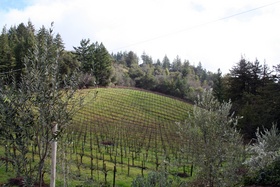
# Employer # of Employees 1 University of California, Santa Cruz 1,000-4,999 2 Pajaro Valley Unified School District 1,000-4,999 3 County of Santa Cruz 1,000-4,999 4 Dominican Hospital 1,000-4,999 5 Santa Cruz Beach Boardwalk 1,000-4,999 6 Cabrillo College 500-999 7 Santa Cruz City School District 500-999 8 City of Santa Cruz 500-999 9 Seagate Technology 500-999 10 Watsonville Community Hospital 500-999 11 West Marine 500-999 12 Plantronics 500-999 Winemaking and wineries
 Vineyard in the Santa Cruz Mountains
 Main article: Santa Cruz Mountain AVA
Winemaking—both the growing of the grapes and their vinting—is an important part of the economic and cultural life of Santa Cruz County. The wines of the David Bruce Winery and Ridge Vineyards were selected for tasting in the Paris Wine Tasting of 1976 (Tabor, p.167-169).
See also
- Hiking trails in Santa Cruz County
- List of school districts in Santa Cruz County, California
- National Register of Historic Places listings in Santa Cruz County, California
Sources
- Taber, George M. Judgment of Paris: California vs. France and the historic 1976 Paris Tasting that Revolutionized Wine. NY: Scribner, 2005.
References
- ^ "Census 2000 U.S. Gazetteer Files: Counties". United States Census. http://www.census.gov/tiger/tms/gazetteer/county2k.txt. Retrieved 2011-02-13.
- ^ flyairmonterey.com
- ^ specializedheli.com
- ^ "2010 Census P.L. 94-171 Summary File Data". United States Census Bureau. http://www2.census.gov/census_2010/01-Redistricting_File--PL_94-171/California/.
- ^ "American FactFinder". United States Census Bureau. http://factfinder.census.gov. Retrieved 2008-01-31.
- ^ Bookwalter, Genevieve (August 15, 2006). "Santa Cruz residents more educated than most". Santa Cruz Sentinel. http://www.santacruzsentinel.com/story.php?sid=40953. Retrieved 2008-02-06[dead link]
- ^ "Santa Cruz County QuickFacts from the US Census Bureau". January 2, 2008. http://quickfacts.census.gov/qfd/states/06/06087.html. Retrieved 2008-04-22
- ^ santacruzpl.org
- ^ McCord, Shanna (June 14, 2011). "Bethany University will close: Private funding didn't materialize". Santa Cruz Sentinel. http://www.santacruzsentinel.com/localnews/ci_18268515. Retrieved June 17, 2011.
- ^ "Santa Cruz County Election Results, November 2004 (pdf)" (PDF). http://www.ss.ca.gov/elections/sov/2004_general/sov_2004_entire.pdf. Retrieved 2006-05-04.
- ^ County of Santa Cruz CAFR
External links
- Santa Cruz County travel guide from Wikitravel
- Santa Cruz Wiki - The People's Guide to Santa Cruz, California
- Santa Cruz County official website
- Historical resources for Santa Cruz County -- from Santa Cruz Public Library
- Santa Cruz County Conference & Visitors Council - Visitor Information
- List of movies shot in Santa Cruz County
- Santa Cruz Metropolitan Transit District
- QuickFacts from the US Census Bureau
Municipalities and communities of Santa Cruz County, California Cities 
CDPs Amesti | Aptos | Aptos Hills-Larkin Valley | Ben Lomond | Bonny Doon | Boulder Creek | Brookdale | Corralitos | Davenport | Day Valley | Felton | Freedom | Interlaken | La Selva Beach | Live Oak | Lompico | Mount Hermon | Pajaro Dunes | Paradise Park | Pasatiempo | Pleasure Point | Rio del Mar | Seacliff | Soquel | Twin Lakes | Zayante
Unincorporated
communitiesOpal Cliffs | Summit | Swanton
Ghost
townCategories:- Santa Cruz County, California
- Metropolitan areas of California
- Counties in the San Francisco Bay Area
- California counties


Wikimedia Foundation. 2010.