- California State Route 152
Infobox road
state=CA
type=SR
route=152
section=452
maint=Caltrans 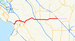
length_mi=104.419
length_ref=
length_round=3
length_notes=(plus about 1.5 mi (2.5 km) on US 101)
history=State highway in 1916; SR 152 in 1934
direction_a=West
terminus_a=jct|state=CA|SR|1 in Watsonville
junction=jct|state=CA|US|101 in Gilroy
jct|state=CA|I|5 near Santa Nella
jct|state=CA|SR|165 in Los Banos
direction_b=East
terminus_b=jct|state=CA|SR|99 near Chowchilla
previous_type=SR
previous_route=151
next_type=SR
next_route=153State Route 152 is a
state highway that runs near the latitudinal middle of theU.S. state ofCalifornia from Watsonville to Route 99 southeast of Merced. Its western portion provides the best access to and from Interstate 5 towardsouthern California for motorists in or near San Jose.This route is part of the
California Freeway and Expressway System [http://www.leginfo.ca.gov/cgi-bin/displaycode?section=shc&group=00001-01000&file=250-257 CA Codes (shc:250-257)] ] and is eligible for the State Scenic Highway System [http://www.leginfo.ca.gov/cgi-bin/displaycode?section=shc&group=00001-01000&file=260-284 CA Codes (shc:260-284)] ] .Route description
Route 152 begins near Route 1 as a series of local streets that run through downtown Watsonville, after which it becomes a winding two-lane highway that crosses the
Santa Cruz Mountains through the Hecker Pass to reach Gilroy where it is again carried on a series of local streets. It is then overlapped onto to North/South U.S. Route 101 for a small stretch before it separates and returns to heading West/East again.After exiting the large commercial developments near US 101, Route 152 consists of a single lane in each direction, with narrow shoulders, rain ditches on either side of the road, no center dividers, and posted speed limit of 55 mph (89 km/h), making it prone to head-on collisions. Headlights are required at all times along this portion. This segment is a significant bottleneck for traffic traveling along Route 152 between the
Bay Area and the Central Valley. Upon reaching Route 156 near Hollister, the road expands to two lanes in each direction, and climbs and curves and through the mountains of theDiablo Range , crossing them through thePacheco Pass into theSan Joaquin Valley .Route 152 continues as a four-lane divided
expressway , descending along the northern and eastern shore of the massiveSan Luis Reservoir . The route passes in between theSan Luis Dam and the O'Neill Forebay. The route continues east and passes a largePath 15 substation and then meets Interstate 5 as an expressway. It becomes a speed-limited city street while passing through Los Banos before returning to an expressway until its eastern terminus at Route 99. Here, eastbound 152 traffic merges on to southbound 99 a few miles northwest of the city of Madera, and approximately 25 miles (40 km) northwest of Fresno. Motorists wishing to travel north on Route 99 are advised to take Route 233 north through Chowchilla to connect to northbound 99. Another possible northbound route exists by exiting Route 152 at State Route 59, and proceeding directly north to the city of Merced, where Route 59 meets Route 99.afety
Between State Route 156 and Interstate 5, Route 152 lacked any kind of center divider and was the site of numerous head on traffic accidents, many of them fatal. In the 1990s a divider measuring from 3 to 6 feet (1 to 2 meters) tall was erected along the majority of the winding parts of the route from 156 to I-5. The barrier has prevented most head on collisions from happening by preventing cars from crossing the highway and striking oncoming traffic. Instead cars bounce back and hit traffic going the same direction. However, on
July 16 ,2005 a fatal multi-car head on collision occurred despite the barrier when a pickup went airborne over the center divider. This stretch of road remains one of the most dangerous in the Bay Area. Traffic accidents between Gilroy and Highway 99 before it was a divided highway were so many that it was given the name and known locally as "Blood Alley." (It should be noted that other state routes in the area have also been given this name from time to time.)On holiday weekends, eastbound Route 152 experiences significant backups at the intersection with State Route 156 caused by motorists who politely but illegally stop to allow cross-traffic to pass. Construction has begun on a fly-by overpass that would eliminate this safety hazard.
Between Gilroy and Watsonville, 152 west is a common route for weekend motorcycle and beach traffic over Hecker pass. The single lane windy mountain pass often causes vehicle collisions, especially with motorcycle riders who exceed their skill level.
History
The road became popular as a route east during the
California Gold Rush . TheButterfield Overland Mail ran along this route from 1858 to 1861. A portion of Route 152 from Bell Station toPacheco Pass was atoll road from sometime in the 1840s until 1878. In that year, Merced County and Santa Clara County purchased the road. It was eventually upgraded to a state route. Historic references say the portion of the route west of SR33 was named "Legislative Route 32" before being designated State Route 152. [Myer, Chuck, report: "Pacheco Past: A History of the Gateway to Santa Clara County", (San Jose, California: Pioneers of Santa Clara County, 1992), page 9.] [ Shumate, Dr. Albert, "Francisco Pacheco of Pacheco Pass", (Stockton, California: University of the Pacific, 1977). This information is repeated in other sources.]Additional landmarks
*
Pacheco Pass
*Gilroy Gardens
*San Luis Reservoir
*Casa de Fruta
*Merry Cherries Major intersections
:"Note: Except where prefixed with a letter,
postmile s were measured in 1964, based on the alignment as it existed at that time, and do not necessarily reflect current mileage. The numbers reset at county lines; the start and end postmiles in each county are given in the county column."References
External links
* [http://www.dot.ca.gov/hq/roadinfo/sr152 Caltrans: Route 152 road conditions]

Wikimedia Foundation. 2010.