- Chowchilla, California
-
City of Chowchilla — City — Location in Madera County and the state of California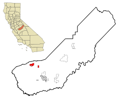
Coordinates: 37°07′23″N 120°15′37″W / 37.12306°N 120.26028°WCoordinates: 37°07′23″N 120°15′37″W / 37.12306°N 120.26028°W Country  United States
State  California
County Madera Area[1] - Total 7.661 sq mi (19.842 km2) - Land 7.661 sq mi (19.842 km2) - Water 0 sq mi (0 km2) 0% Elevation[2] 240 ft (73 m) Population (2010) - Total 18,720 - Density 2,443.5/sq mi (943.5/km2) Time zone Pacific (PST) (UTC-8) - Summer (DST) PDT (UTC-7) ZIP code 93610 Area code(s) 559 FIPS code 06-13294 GNIS feature ID 0277601 Website http://www.ci.chowchilla.ca.us/ Chowchilla is a city in Madera County, California, United States.[2] Chowchilla is located 15 miles (24 km) northwest of Madera,[3] at an elevation of 240 feet (73 m).[2] It is a principal city of the Madera–Chowchilla Metropolitan Statistical Area.[4] The population was 18,720 at the 2010 census, up from 11,127 at the 2000 census. The city is the location of two California Department of Corrections and Rehabilitation women's facilities, the Central California Women's Facility and Valley State Prison for Women. The name "Chowchilla" is derived from the Native American tribe of Chauchila (the spelling is inconsistent in reference guides) Yokut Indians which once lived in the area. The name itself evidently translates as "Murderers" and is apparently a reference to the warlike nature of the Chauchila tribe. The Chauchila Indians were inadvertently responsible for the first white men "discovering" Yosemite Valley, which occurred when the Chauchila Indians were being pursued by a band of whites. References to the Indian tribe still abound in Chowchilla, and the town's high school still retains the moniker of "Redskins" as their local mascot.
Contents
History
The first post office at Chowchilla opened in 1912.[3] Chowchilla incorporated in 1923.[3] The population includes that of both prisons and that should be included in the population information.
1976 bus kidnapping
Chowchilla was launched into national headlines on July 15, 1976 when an entire school bus of children was kidnapped. Twenty-six children and the adult bus driver were taken from the bus, which the kidnappers concealed in a drainage slough, and driven around in two vans for 11 hours before being forced, one by one, to climb into a hole in the ground. After passing through the hole the children and their driver found themselves trapped in the interior of a buried moving van. Although they did not know it, their place of confinement was in a quarry located in Livermore, California.
By stacking the 14 mattresses that were in the van, local farmer and part-time bus driver Ed Ray and some of the older children were able to reach the opening at the top of the truck, which had been covered with a metal lid and weighed down. They were able to wedge the lid open with a stick, and Ray was able to move the two 100-pound industrial batteries atop the lid. Ray and the boys were able to remove the remainder of the debris blocking the entrance. After 16 hours underground they emerged and walked to the guard shack at the entrance to the quarry. The guard alerted the authorities and all the victims were pronounced in good condition, and returned home to find that mass media had descended on the town.
Ray was able to remember the license plate number of one vehicle under hypnosis, which led to the capture of the kidnappers as they attempted to flee to Canada. A rough draft of a ransom note was found at the house of the owner of the quarry. The owner's son, Frederick Woods, and two friends, Richard and James Schoenfeld, were found guilty and sentenced to life in prison.[5] The ordeal was dramatized in the 1993 ABC-TV movie They've Taken Our Children: The Chowchilla Kidnapping (shown in the UK as Vanished Without a Trace) starring Karl Malden, which is sometimes shown on the Biography Channel. Interviews with many of the children, now adults, including Mike and bus driver Ray were broadcast on MSNBC Dark Heart Iron Hand.
After the children were recovered, it was observed that some circumstances of the abduction corresponded to details in "The Day the Children Vanished", a story written by Hugh Pentecost that had been published in the 1969 fiction anthology Alfred Hitchcock's Daring Detectives. A copy of this book was in the Chowchilla public library; police theorized that this was the source of the real-life kidnappers' inspiration.[6]
After being denied parole 20 times, one of the three kidnappers, Richard Schoenfeld, was deemed suitable for parole by the California Board on Parole Hearings on October 30, 2008. He was denied parole in August 2009.
James Schoenfeld has been denied parole 16 times. Frederick Woods was denied parole for the 12th time on January 5, 2009 and will be eligible again in 2012.[7] Richard Schoenfeld has been granted parole on April 5, 2011, and he will be released from prison on November 13, 2021.[8]
Geography
Chowchilla is located at 37°07′23″N 120°15′37″W / 37.12306°N 120.26028°W.[2]
According to the United States Census Bureau, the city has a total area of 7.7 square miles (20 km2), all of it land.
Climate
The climate of Chowchilla is Mediterranean. Chowchilla receives an average of about 12 inches of precipitation per year. The wettest months are January, February, and March with March being the wettest. Chowchilla has dry, hot summers, and mild to cool, rainy winters. Chowchilla experiences frequent fog from November to March and overcast days are common, especially in January. In 2005, Chowchilla had 20 consecutive cloudy, rainy days. There are days with moderate to heavy rain during the winter months. In January, the high temperature may drop as low as 45°F (9°C). During the summer, when there is usually no rain, the temperature may reach as high as 110°F (43°C). Snow in Chowchilla is rare.
Government and infrastructure
The city is the location of two California Department of Corrections and Rehabilitation women's facilities, the Central California Women's Facility and Valley State Prison for Women.[9] Central California Women's houses the state's female death row.[10]
High Speed Rail
Chowchilla is the proposed northern terminus of the first leg of the California high speed rail. [11]
Soccer
In the past few years Chowchilla has had good soccer players, Chowchilla High has been champions 2006, 2007, 2008, 2009, 2010, and 2011 for either Junior Varsity or Varsity. Since 2006 Chowchilla has a soccer teamed named Chowchilla Gladiators and they currently play in "CYSA" California Youth Soccer Association, and have been champions 3 times. For the 2010-2011 season they were named CYSA Central California Champions for the under 16 age group and as a recognition CYSA gave them each a medal saying "CYSA 2010-2011 Central California Champions". They also play tournaments in Las Vegas. Chowchilla Gladiators are linked up with the Chowchilla Union High soccer program and have a good relationship with the coaches. On July 9th 2011 Gladiators took 3rd place in the Porterville tournament
Education
There are two school districts in Chowchilla. The Chowchilla School District and The Chowchilla Union High School District.
School Districts in Chowchilla Chowchilla Union High School Serves Grades 9-12
Chowchilla School District Serves Grades K-8. Schools in the Chowchilla School District Stephens School, Fuller School, Ronald Reagan School, Fairmead School, Wilson School Chowchilla Seventh Day Adventist K-8
Demographics
2010
The 2010 United States Census[12] reported that Chowchilla had a population of 18,720. The population density was 2,443.5 people per square mile (943.4/km²). The racial makeup of Chowchilla was 11,533 (61.6%) White, 2,358 (12.6%) African American, 376 (2.0%) Native American, 395 (2.1%) Asian, 37 (0.2%) Pacific Islander, 3,313 (17.7%) from other races, and 708 (3.8%) from two or more races. Hispanic or Latino of any race were 7,073 persons (37.8%).
The Census reported that 11,311 people (60.4% of the population) lived in households, 6 (0%) lived in non-institutionalized group quarters, and 7,403 (39.5%) were institutionalized.
There were 3,673 households, out of which 1,693 (46.1%) had children under the age of 18 living in them, 1,932 (52.6%) were opposite-sex married couples living together, 586 (16.0%) had a female householder with no husband present, 260 (7.1%) had a male householder with no wife present. There were 275 (7.5%) unmarried opposite-sex partnerships, and 24 (0.7%) same-sex married couples or partnerships. 721 households (19.6%) were made up of individuals and 293 (8.0%) had someone living alone who was 65 years of age or older. The average household size was 3.08. There were 2,778 families (75.6% of all households); the average family size was 3.52.
The population was spread out with 3,583 people (19.1%) under the age of 18, 2,048 people (10.9%) aged 18 to 24, 7,343 people (39.2%) aged 25 to 44, 4,429 people (23.7%) aged 45 to 64, and 1,317 people (7.0%) who were 65 years of age or older. The median age was 34.7 years. For every 100 females there were 42.7 males. For every 100 females age 18 and over, there were 33.3 males.
There were 4,154 housing units at an average density of 542.2 per square mile (209.3/km²), of which 1,966 (53.5%) were owner-occupied, and 1,707 (46.5%) were occupied by renters. The homeowner vacancy rate was 6.2%; the rental vacancy rate was 7.9%. 5,920 people (31.6% of the population) lived in owner-occupied housing units and 5,391 people (28.8%) lived in rental housing units.
2000
As of the census[13] of 2000, there were 11,127 people, 2,562 households, and 1,908 families residing in the city. The population density was 1,567.4 people per square mile (605.1/km²). There were 2,711 housing units at an average density of 381.9 per square mile (147.4/km²). The racial makeup of the city was 63.46% White, 10.26% Black or African American, 2.60% Native American, 1.32% Asian, 0.26% Pacific Islander, 16.16% from other races, and 5.94% from two or more races. 28.20% of the population were Hispanic or Latino of any race.
There were 2,562 households out of which 40.2% had children under the age of 18 living with them, 55.3% were married couples living together, 13.2% had a female householder with no husband present, and 25.5% were non-families. 21.9% of all households were made up of individuals and 12.6% had someone living alone who was 65 years of age or older. The average household size was 2.94 and the average family size was 3.42.
In the city the population was spread out with 22.2% under the age of 18, 9.4% from 18 to 24, 42.8% from 25 to 44, 16.2% from 45 to 64, and 9.3% who were 65 years of age or older. The median age was 34 years. For every 100 females there were 51.1 males. For every 100 females age 18 and over, there were 39.8 males.
The median income for a household in the city was $30,729, and the median income for a family was $35,741. Males had a median income of $32,306 versus $20,538 for females. The per capita income for the city was $11,927. About 16.5% of families and 19.2% of the population were below the poverty line, including 27.1% of those under age 18 and 7.6% of those age 65 or over.
Politics
In the state legislature Chowchilla is located in the 14th Senate District, represented by Republican Tom Berryhill, and in the 25th Assembly District, represented by Republican Kristin Olsen. Federally, Chowchilla is located in California's 19th congressional district, which has a Cook PVI of R +10[14] and is represented by Republican Jeff Denham.
References
- ^ U.S. Census
- ^ a b c d U.S. Geological Survey Geographic Names Information System: Chowchilla, California
- ^ a b c Durham, David L. (1998). California's Geographic Names: A Gazetteer of Historic and Modern Names of the State. Quill Driver Books. p. 758. ISBN 9781884995149.
- ^ "Update of Statistical Area Definitions and Guidance on Their Uses (OMB Bulletin 09 - 01)" (CSV). Office of Management and Budget, Executive Office of the President. 2008-11-20. http://www.whitehouse.gov/omb/bulletins/fy2009/09-01.pdf. Retrieved 2008-12-17.
- ^ Chowchilla Calif school bus kidnapping - The Crime Library - The Crime library
- ^ "CRIME: Escape from an Earthen Cell". Time. July 26, 1976. http://www.time.com/time/magazine/article/0,9171,914378,00.html. Retrieved April 28, 2010.
- ^ '76 Chowchilla bus hijacker deemed 'suitable' for parole - Madera Tribune
- ^ Parole granted for one of three Chowchilla bus kidnappers - abc30.com
- ^ "Chowchilla city, California." U.S. Census Bureau. Retrieved on May 10, 2010.
- ^ "History of Capital Punishment in California." California Department of Corrections. Retrieved on August 16, 2010. "All male prisoners on condemned status are housed at a maximum-security custody level in three units at San Quentin State Prison. Females are housed in a maximum-security unit at Central California Women’s Facility in Chowchilla."
- ^ "[1]"
- ^ All data are derived from the United States Census Bureau reports from the 2010 United States Census, and are accessible on-line here. The data on unmarried partnerships and same-sex married couples are from the Census report DEC_10_SF1_PCT15. All other housing and population data are from Census report DEC_10_DP_DPDP1. Both reports are viewable online or downloadable in a zip file containing a comma-delimited data file. The area data, from which densities are calculated, are available on-line here. Percentage totals may not add to 100% due to rounding. The Census Bureau defines families as a household containing one or more people related to the householder by birth, opposite-sex marriage, or adoption. People living in group quarters are tabulated by the Census Bureau as neither owners nor renters. For further details, see the text files accompanying the data files containing the Census reports mentioned above.
- ^ "American FactFinder". United States Census Bureau. http://factfinder.census.gov. Retrieved 2008-01-31.
- ^ "Will Gerrymandered Districts Stem the Wave of Voter Unrest?". Campaign Legal Center Blog. http://www.clcblog.org/blog_item-85.html. Retrieved 2007-10-20.
External links
- From Sun to Darkness — The Chowchilla Kidnapping
- Madera Online - News for Madera & Chowchilla
- Chowchilla City Website
Municipalities and communities of Madera County, California Cities Chowchilla | Madera
CDPs Ahwahnee | Bass Lake | Bonadelle Ranchos-Madera Ranchos | Coarsegold | Fairmead | La Vina | Madera Acres | Nipinnawasee | Oakhurst | Parksdale | Parkwood | Rolling Hills | Yosemite Lakes
Unincorporated
communitiesAhwahnee Estates | Bass Lake Annex | Berenda | Bonadelle Ranchos | Bonadelle Ranchos Five | Bonadelle Ranchos Nine | Bonita | Borden | Cascadel Woods | Central Camp | Dairyland | Daulton | Fine Gold | Fresno Crossing | Gregg | Hildreth | Indian Lakes Estates | Indian Springs | Irrigosa | Italian Swiss Colony | Kismet | Knowles | Knowles Junction | Lake Madera Country Estates | Madera Country Club Estates | Madera Highlands | Madera Ranchos | Minturn | North Fork | Notarb | Old Corral | O'Neals | Raymond | Ripperdan | River Road Estates | San Joaquin River Estates | Sharon | Sierra Vista | South Fork | Storey | Sugar Pine | Sumner Hill | The Pines | Trigo | Valley Lake Ranchos | Whisky Falls | Yosemite Forks | Yosemite Lakes Park
Indian
reservationsGhost towns Ash | Bailey Flats | Bethel | Birch | Buchanan | Califa | Cascadel | Femmon | Fort Miller | Gertrude | Gold | Grub Gulch | Herbert | Hillside | Jesbel | Lankershim | Lincoln | Magnet | Medano | Miami | Millerton | Minarets | Narbo | Oak | Ovejo | Plains | Rallsville | Starville | Talbot | Tharsa | Tillman | Tyler | Watt | Willow Glen | Wishon
Categories:- Incorporated cities and towns in California
- Cities in Madera County, California
- Chowchilla, California


Wikimedia Foundation. 2010.