California State Route 145
- California State Route 145
Infobox road
state=CA
type=SR
route=145
section=445
maint=Caltrans
length_mi=67
length_round=0
length_ref= [ [http://www.dot.ca.gov/hq/structur/strmaint/brlog2.htm January 1, 2006 California Log of Bridges on State Highways] ]
direction_a=South
terminus_a=jct|state=CA|I|5|SR|33 near Coalinga
junction=jct|state=CA|SR|180 in Kerman
jct|state=CA|SR|99 in Madera
direction_b=North
terminus_b=jct|state=CA|SR|41 near Friant
previous_type=SR
previous_route=144
next_type=SR
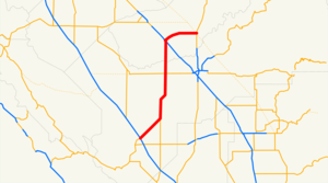
next_route=146State Route 145 is a state highway in California, USA, which runs through the heart of the San Joaquin Valley from Interstate 5 north to Route 41 north of Fresno.
This route is part of the California Freeway and Expressway System[ [http://www.leginfo.ca.gov/cgi-bin/displaycode?section=shc&group=00001-01000&file=250-257 CA Codes (shc:250-257)] ] .]
Route description
The southern terminus of SR 145 is at I-5 near Coalinga. The route travels through the center of the San Joaquin Valley, remaining a rural two-lane road in its entirety. Various crops such as cotton, table grapes, tomatoes and melons are grown along the route in one of the most productive agricultural areas in the world.
SR 145 intersects with SR 180 in Kerman, where it continues north to cross SR 99 in Madera. From Madera, the route turns east, and ends at SR 41.
Major intersections
:"Note: Except where prefixed with a letter, postmiles were measured in 1964, based on the alignment as it existed at that time, and do not necessarily reflect current mileage. The numbers reset at county lines; the start and end postmiles in each county are given in the county column."
References
External links
* [http://www.westcoastroads.com/california/ca-145.html California @ WestCostRoads.com - State Route 145]
* [http://www.dot.ca.gov/hq/roadinfo/sr145 Caltrans: Route 145 highway conditions]
* [http://www.cahighways.org/145-152.html#145 California Highways: Route 145]
* [http://www.geocities.com/bennyp81/ca145.html The Big Highways Page: California Route 145]
Wikimedia Foundation.
2010.
Look at other dictionaries:
California State Route 145 — Karte … Deutsch Wikipedia
California State Route 269 — Infobox road state=CA type=SR route=269 section=569 maint=Caltrans length mi=30 length round=0 length ref= [ [http://www.dot.ca.gov/hq/structur/strmaint/brlog2.htm January 1, 2006 California Log of Bridges on State Highways] ] direction a=South… … Wikipedia
California State Route 86 — Karte … Deutsch Wikipedia
California State Route 41 — CA 41 redirects here. For the congressional district, see California s 41st congressional district. State Route 41 … Wikipedia
California State Route 33 — CA 33 redirects here. For the congressional district, see California s 33rd congressional district. State Route 33 … Wikipedia
California State Route 91 — Infobox road state=CA type=SR route=91 alternate name=Artesia Boulevard, Gardena Freeway, Artesia Freeway, Riverside Freeway section=391 maint=Caltrans length mi=59.047 length round=3 length ref= history=1930s as a highway; 1964 as number… … Wikipedia
California State Route 146 — Infobox road state=CA type=SR route=146 section=446 maint=Caltrans length mi=13 length round=0 length ref= [ [http://www.dot.ca.gov/hq/structur/strmaint/brlog2.htm January 1, 2006 California Log of Bridges on State Highways] ] direction a=West… … Wikipedia
California State Route 118 — Infobox road state=CA type=SR route=118 alternate name=Ronald Reagan Freeway section=418 maint=Caltrans length mi=46.68 length round=2 length ref= [ [http://www.dot.ca.gov/hq/structur/strmaint/brlog2.htm January 1, 2006 California Log of Bridges… … Wikipedia
California State Route 150 — Infobox road state=CA type=SR route=150 section=450 maint=Caltrans length mi=36 length round=0 length ref= [ [http://www.dot.ca.gov/hq/structur/strmaint/brlog2.htm January 1, 2006 California Log of Bridges on State Highways] ] direction a=West… … Wikipedia
California State Route 144 — Infobox road state=CA type=SR route=144 section=444 maint=Caltrans length mi=2 length round=0 length ref= [ [http://www.dot.ca.gov/hq/structur/strmaint/brlog2.htm January 1, 2006 California Log of Bridges on State Highways] ] direction a=South… … Wikipedia
