- Coalinga, California
-
City of Coalinga — City — Coalinga City Hall Location in Fresno County and the state of California
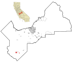
Coordinates: 36°08′23″N 120°21′37″W / 36.13972°N 120.36028°WCoordinates: 36°08′23″N 120°21′37″W / 36.13972°N 120.36028°W Country  United States
State  California
County Fresno Government - Mayor Ron Ramsey - Senate Dean Florez (D) - Assembly Danny Gilmore (R) - U. S. Congress Jim Costa (D) Area[1] - Total 6.150 sq mi (15.927 km2) - Land 6.119 sq mi (15.847 km2) - Water 0.031 sq mi (0.08 km2) 0.50% Elevation 673 ft (205 m) ZIP code 93210 Area code(s) 559 FIPS code 06-14274 GNIS feature ID 1652687 Website http://www.coalinga.com Coalinga (
 /ˌkoʊ.əˈlɪŋɡə/ or /kəˈlɪŋɡə/; formerly, Coaling Station A, Coalingo[2] and Coalinga Station[3]) is a city in Fresno County, California. The population was 13,380 at the 2010 census, up from 11,668 at the 2000 census. It is the site of both Pleasant Valley State Prison and Coalinga State Hospital. Coalinga is located 52 miles (84 km) southwest of Fresno,[2] at an elevation of 673 feet (205 m).[3]
Contents
History
Early days
Legendary bandit Joaquin Murrieta was killed in 1853 north of Coalinga. California Historical Landmark 344, near the intersection of what are now State Routes 33 and 198, marks the approximate site of his headquarters, Arroyo de Cantua, where he was slain.
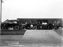 Coalinga gets its first load of Model T cars, about 1914
In the early years of railroading, before the extensive development of oil production in California, the steam locomotives were powered by the burning of coal obtained from the northern foothills of Mount Diablo. The Southern Pacific Transportation Company established the site as a coaling station in 1888, and it was called simply Coaling Station A. Local tradition has it that an official of Southern Pacific made the name more sonorous by adding an a to it.[4] The resemblance to Nahuatl (where cōātl = "snake") is accidental.
The first post office was established in 1899.[2] The city incorporated in 1906.[2]
Water
Coalinga's water was so full of minerals that potable water had to be brought in by railroad in tanker cars from Armona, California. For many years, "Armona Water" was the only water residents could drink. And Coalinga was one of only a few towns in the US that had three taps - one for hot water, one for cold water, and one for drinking water. Finally, in the early 1960s, Coalinga held the first practical demonstration for reverse osmosis (RO), and its Armona water was replaced by RO water.[citation needed]
1983 Earthquake
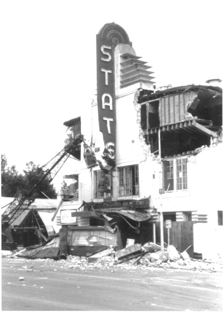
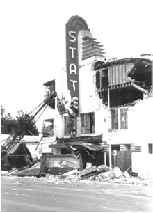 State Theater on Elm Avenue, damaged by 1983 earthquake.
On May 2, 1983, Coalinga was struck by a 6.5 magnitude earthquake that destroyed more than 800 houses and other buildings; it was felt as far away as Los Angeles and western Nevada.
Geology and topography
The Coalinga area is a generally level topographic setting, suitable for a number of field crops which do not require large amounts of water. Underlying rock formations include the occurrence of Vaqueros sandstone. Surrounding the town in a semicircle from the west, around the north, and to the east are several anticlinal formations containing considerable accumulations of petroleum, from which oil has been withdrawn for more than a hundred years.
The city is located near a particularly active portion of the San Andreas Fault, and earthquakes are frequent.
Economy
Today, the city's main industries are agriculture, oil and incarceration. The city is home to the Harris Ranch Beef Company; the Coalinga Oil Field, operated by Chevron and Aera Energy; the Guijarral Hills Oil Field; Pleasant Valley State Prison; and Coalinga State Hospital.
Coalinga is home to California's first new mental health hospital in more than 50 years: a 1,500-bed facility built specifically to house sexually violent predators. Coalinga State Hospital opened in September 2005.
Education
 Coalinga High School.
Coalinga is the site of the primary campus of West Hills College, which is part of the California Community Colleges system. Its children are served by the Coalinga-Huron Unified School District, of which Coalinga High School is a part.
Population
2010
The 2010 United States Census[5] reported that Coalinga had a population of 13,380. The population density was 2,175.8 people per square mile (840.1/km²). The racial makeup of Coalinga was 7,734 (57.8%) White, 549 (4.1%) African American, 171 (1.3%) Native American, 407 (3.0%) Asian, 36 (0.3%) Pacific Islander, 3,937 (29.4%) from other races, and 546 (4.1%) from two or more races. Hispanic or Latino of any race were 7,161 persons (53.5%).
 Coalinga house in 2009
The Census reported that 11,752 people (87.8% of the population) lived in households, 130 (1.0%) lived in non-institutionalized group quarters, and 1,498 (11.2%) were institutionalized.
There were 3,896 households, out of which 1,809 (46.4%) had children under the age of 18 living in them, 1,913 (49.1%) were opposite-sex married couples living together, 658 (16.9%) had a female householder with no husband present, 311 (8.0%) had a male householder with no wife present. There were 341 (8.8%) unmarried opposite-sex partnerships, and 16 (0.4%) same-sex married couples or partnerships. 797 households (20.5%) were made up of individuals and 220 (5.6%) had someone living alone who was 65 years of age or older. The average household size was 3.02. There were 2,882 families (74.0% of all households); the average family size was 3.49.
The population was spread out with 3,763 people (28.1%) under the age of 18, 1,610 people (12.0%) aged 18 to 24, 3,646 people (27.2%) aged 25 to 44, 3,308 people (24.7%) aged 45 to 64, and 1,053 people (7.9%) who were 65 years of age or older. The median age was 31.9 years. For every 100 females there were 123.1 males. For every 100 females age 18 and over, there were 132.1 males.
There were 4,344 housing units at an average density of 706.4 per square mile (272.7/km²), of which 1,996 (51.2%) were owner-occupied, and 1,900 (48.8%) were occupied by renters. The homeowner vacancy rate was 3.8%; the rental vacancy rate was 8.4%. 6,192 people (46.3% of the population) lived in owner-occupied housing units and 5,560 people (41.6%) lived in rental housing units.
2000
At the census of 2000, there were 11,668 people, 3,515 households, and 2,632 families residing in the city. These included 805 people who were living in group homes.[6]
The racial makeup of Coalinga under those circumstances was 57.3 percent white, 2.4 percent African American, 1.5 percent Native American, 1.7 percent Asian, 0.2 percent Pacific Islander, 32.3 percent from other races, and 4.6 percent from two or more races. About half the population was Hispanic or Latino.
The median age in 2000 was 28.6 years, younger than the 33.3 figure for California and the 35.3 figure for the United States as a whole.
The median income for a family was $41,208, about $11,000 less than for other families in California or the country at large.
The Coalinga Chamber of Commerce Web site in 2007 estimated a population of 18,061 for the city.
2000 figures Coalinga California United States Median age 28.6 33.3 35.3 White 57.3% 59.5% 75.1% African-American 2.4% 6.7% 12.3% Hispanic/Latino 49.8% 32.4% 12.5% Family income $41,208 $53,025 $50,046 Poverty families 16.4% 10.6% 9.2% Med. home value $86,900 $211,500 $119,600 High school diploma 65.0% 76.8% 80.4% College degree 11.8% 28.6% 24.4% Notes: "Family income" is median family income in 1999 dollars. "Med. home value" is the median value of single-family houses. "Poverty families" is the percentage of families with incomes below the poverty level. "High school diploma" is the percentage of people 25 years and over who had graduated from high school.
Attractions
The Harris Ranch, a major cattle ranch which also features a hotel, several restaurants, and a gift shop, is east of Coalinga, near Interstate 5.
Coalinga hosts the Horned Toad Derby each year over the Memorial Day weekend in late May.[7] The three-day event is similar to the more famous Jumping Frog Jubilee held in Calaveras County, California, but utilizes locally caught horned toads rather than frogs. This tradition began in 1935.[8]
On the November weekend closest to Montgolfiere Day (November 21) each year, Coalinga is host to the annual WHAMOBASS Balloon Rally, the longest consecutively running annual hot air balloon rally in the world, sponsored by the Whiskey Hill Atherton Menlo Oaks Ballooning & Sporting Society. Typically, more than 40 balloons ascend at dawn on Saturday and Sunday morning from the athletic field of West Hills College. A small number fly on Friday and occasionally on Thursday.[9]
The R.C. Baker Memorial Museum is housed in the former Baker Oil Tools machine shop. The museum continues to accept items from visitors to add to its collection. The museum displays local fossils, models of prehistoric fauna, native American artifacts, and items from pioneer settlers.
Notable residents
- Stanley George "Frenchy" Bordagaray, athlete
- Jo Stafford, musician
- Sirhan Sirhan, convicted of murdering Robert F. Kennedy. He is housed in the Pleasant Valley State Prison.
References
- ^ U.S. Census
- ^ a b c d Durham, David L. (1998). California's Geographic Names: A Gazetteer of Historic and Modern Names of the State. Quill Driver Books. p. 1018. ISBN 9781884995149.
- ^ a b U.S. Geological Survey Geographic Names Information System: Coalinga, California
- ^ William Bright, 2004, California Place Names: The Origin and Etymology of Current Geographical Names
- ^ All data are derived from the United States Census Bureau reports from the 2010 United States Census, and are accessible on-line here. The data on unmarried partnerships and same-sex married couples are from the Census report DEC_10_SF1_PCT15. All other housing and population data are from Census report DEC_10_DP_DPDP1. Both reports are viewable online or downloadable in a zip file containing a comma-delimited data file. The area data, from which densities are calculated, are available on-line here. Percentage totals may not add to 100% due to rounding. The Census Bureau defines families as a household containing one or more people related to the householder by birth, opposite-sex marriage, or adoption. People living in group quarters are tabulated by the Census Bureau as neither owners nor renters. For further details, see the text files accompanying the data files containing the Census reports mentioned above.
- ^ U.S. Census figures
- ^ KFSN ABC TV – Horned Toad Derby
- ^ Bakersfield.com – Horned toad derby of 1935
- ^ WHAMOBASS Hot Air Balloon Festival
http://www.rcbakermuseum.com/home.html
External links
- Coalinga Chamber of Commerce: History of Coalinga
- Historical Photographs of Coalinga (1910-1925), The Bancroft Library
Municipalities and communities of Fresno County, California Cities 
CDPs Auberry | Big Creek | Biola | Bowles | Calwa | Cantua Creek | Caruthers | Centerville | Del Rey | Easton | Fort Washington | Friant | Lanare | Laton | Malaga | Mayfair | Minkler | Monmouth | Old Fig Garden | Raisin City | Riverdale | Shaver Lake | Squaw Valley | Sunnyside | Tarpey Village | Three Rocks | Tranquillity | West Park
Unincorporated
communitiesAlder Springs | Arbios | Avocado | Balch Camp | Barstow | Benito | Big Bunch | Biola Junction | Bretz Mill | Broadview Farms | Burness | Burrel | Calflax | Camden | Cameo | Camp Sierra | Cecile | Cedar Crest | Cedar Grove | Cedarbrook | Cella | Chaney Ranch | Cincotta | Clint | Clotho | Conejo | Crabtree | Cromir | Deer Crossing | Dinkey Creek | Dora Belle | Dunlap | Edmiston | Elk | Elm View | Etheda Springs | Figarden | Five Points | Floyd | Giffen Cantua Ranch | Glorietta | Goldleaf | Goodmill | Gordon | Gravesboro | Helm | Herndon | Highway City | Hoffman Point | Hub | Hume | Hume Station | Humphreys Station | Huntington Lake | Ingle | Ivesta | Jamesan | Kanawyers | La Jolla Ranch | Lacjac | Lakeshore | Lerona | Levis | Locans | Lone Star | Marshall Junction | Mathews Mill | Mattei | Meadow Lakes | Mercey Hot Springs | Miley | Miramonte | Mono Hot Springs | Murietta Farm | Muscatel | Navelencia | New Auberry | Ockenden | Old Bretz Mill | Oleander | Ora | Oro Loma | Oxalis | Panoche Junction | Parkfield Junction | Piedra | Pilibos Ranch | Pinehurst | Pineridge | Prather | Pratton | Raco | Riverbend | Rock Haven | Rodgers Crossing | Rolinda | Sawmill Flat | Schilling | Shaver Lake Heights | Sierra Cedars | Sierra Sky Park | Snow Bend | Tarpey | Tollhouse | Trimmer | Turk | Uva | Vanguard | Wahtoke | Westhaven | Westside | Wildflower | Wineland | Wolf | Wood Ranch | Zediker
Indian
reservationsBig Sandy Rancheria | Cold Springs Rancheria | Table Mountain Rancheria
Ghost towns Andrews | Barton | Bender | Bridge | Bronge | Butler | Cadogan | Caldwell | Carlile | Carmelita | Coalinga Mineral Springs | Collins | Darwin | Dathol | Deseret | Dickerson | El Prado | Elkhorn Station | Eshel | Everts | Fargo | Fort Camp | Fresno Beach | Fresno City | Fruitvale | Garfield | Granz | Hawthorne's Station | Hayes | Kelso | Kingriver | Kingston | La Libertad | Last | Leroy | Letcher | Lillis | Marshall Station | McKenzie Spring | McMullin | Mendota Station | Millerton | Mountain Rest | Nares | Nevills | Oakhurst | Oleander | Peteras Mill | Pinedale | Pool's Ferry | Pool's Fort | Poso de Chane | Portal | Pueblo de las Juntas | Rancho de los Californios | Reka | Riverview | Robinson | Rogers | Rugg | Sanders | Sentinel | Sharpville | Shaver | Shipp | Smith's Ferry | Sparkville | Tarn | Temperance | Thermal | Tisechu | Vanris | Vino | Warsaw
Categories:- Incorporated cities and towns in California
- Cities in Fresno County, California
- Populated places established in 1888
- Populated places in California with Hispanic majority populations


Wikimedia Foundation. 2010.